
Excerpts
from Sierra Club's public comments to the US Army Corps of
Engineers
�Wetland
and Stream Mitigation and Monitoring Guidelines�
As
New York State Wetlands Chair for Sierra Club, I respectfully submit these
public comments regarding the Buffalo District�s mitigation and monitoring
guidelines. We appreciate this opportunity to submit
suggestions to improve the guidelines in light of regional
conditions.
I
often receive calls from stunned residents who unwittingly buy a house that was
built in a wetland, floodplain, or near a stream. Too few members of the general public
know the ramifications until they suffer a disaster of some type with their
homes.
Although
the guidelines state that, �Wetland permit applicants are required to
demonstrate that a proposed project results in the least environmentally
damaging practicable alternative and must first demonstrate that impacts to
aquatic resources have been avoided and minimized to the maximum extent possible
before any mitigation plan will be considered for approval� � it often
seems that this is not the case. Developers knowingly purchase properties with
wetlands long after the laws to protect wetlands were enacted. They claim that
since they aren�t going to disturb all the wetlands on their project sites that
this somehow minimizes and avoids wetlands.
The
flaws in this thought process can be seen in recent permit applications posted
over the last month on the Corps' web site for residential subdivisions proposed
in wetlands in Pendleton and Clarence, NY.
Developers claim if they don�t develop wetlands then their projects
aren�t �economically feasible�.
Obviously, the wetland properties were cheap enough to consider including
mitigation as a mere cost of doing business. Do developers truly care about the
impacts to families who eventually purchase and live in the new homes they build
in wetlands?
A
national mitigation checklist has been expanded by the Buffalo District to
account for specific regional differences that occur within the District. This is a good start, but we suggest
that it be expanded more. First,
and foremost, residential home developers must be made to realize that their
negotiations with regulators for mitigation in exchange for permits to build
homes in wetlands must carry with it the added responsibility of total
disclosure to future homeowners.
A
condition prior to issuing a federal wetland/stream/floodplain permit must be
that a copy of the permit application be given to the prospective homeowner
prior to the signing of a purchase contract for the construction of the new
home. Some developers may try to
circumvent this process by using relatives and associates as the �so-called�
future homeowner at this stage, so an added requirement should be that the
wetland permit must also be attached to the deeds for homes built in wetlands
and recorded in the appropriate county courthouse prior to the real estate
closing on the homes. In this way,
when future homeowners make economic decisions about purchasing a home, they can
weigh the fact that the home was constructed in wetlands.
If
this condition cannot be accomplished throughout the Buffalo District, at the
very least, it must be seriously considered for homes to be constructed in areas
with similar geological and glacial histories as the portion of Amherst that is
experiencing the �sinking homes� phenomena. The Corps has not yet completed a study
of over 1,000 homes in Amherst, NY, that have structural problems from unstable,
and often hydric, soils.
Approving more wetland permits in ancient glacial lake areas before this
study is complete opens the Corps up to possible lawsuits.
Glaciers
were responsible for shaping the landscape of Western New York. About 13,000
years ago, after the last ice age, there was a huge glacial lake, called Lake
Tonawanda that covered much of what would become Amherst. When this lake dried
up, the land in Amherst, north of Williamsville, was left a swampy, wetland
area. Williamsville is located
almost directly on the underlying Onondaga Limestone bedrock. Williamsville does not have the layers
of overlying glacial lake clays, silts, and sands that may be causing the
problems with homes further north in Amherst that were located in Lake Tonawanda
or the Niagara Falls Moraine (see the map that follows).
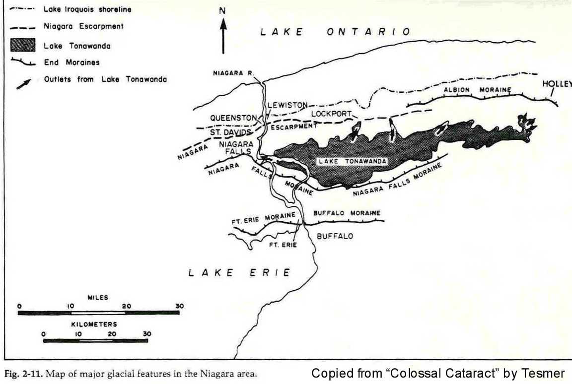
Much
of Amherst was built on flat land that is essentially swampy in nature. Grand
Island and much of the Tonawandas is built on thick clay sediment, with a local
moraine crossing north of Grand Island at the shoreline of glacial Lake
Tonawanda. Foundations and basements must be built and drained correctly to
remain stable and prevent crack formation.
County soil surveys clearly indicate the problems with structures built
in these soils but this information is ignored.
Wetland
permits should not be granted in communities located in, or near, the outline of
glacial Lake Tonawanda until consumers and builders are better informed of the
risks. Flooding, cracked basements,
exposure to pesticides that are used to lower insect populations, are just some
of the reasons to prohibit building homes in wetlands.
Piecemeal
development in wetlands becomes rampant once regulatory agencies �open� a
wetland to new homes. For example,
take the case of the Klydel Wetland, an exemplary, mature forested wetland in
North Tonawanda. This wetland was featured in October 2001 by Sierra Club and
the Clean Water Network in a nationwide postcard campaign to the US Army Corps
of Engineers (during the nationwide wetland permit comment period). This wetland has had cumulative impacts
of about 20+ acres lost to date of the original 102 wetland acres mapped by
NYSDEC. This wetland is being
destroyed by subdivisions that were grandfathered by NYSDEC and built in large
part without any application for federal wetland permits.
Many
cumulative losses to the Klydel Wetland cannot be found in Corps� documentation
and no party has mitigated for the losses there. Sierra Club and Citizens for a
Green North Tonawanda filed a notice to US EPA of the intent to sue the
City under the citizens suit provision of the Clean Water Act on September 29,
2003.
New
York State Freshwater Wetlands Permit Requirements Regulations (pursuant to
Article 24 of the Environmental Conservation Law) states in Subdivision 663.4(d), Procedural Requirements, that
statewide minimum land-use regulations contained in subdivision
665.7(g) establish the compatibility categories to be used in conjunction with
the different types of land-use activities to be conducted upon freshwater
wetlands or adjacent areas. Under the category �Buildings� it is stated: �Constructing buildings, accessory
roads, and parking areas can have several effects on wetlands, not the least of
which is the increased pressure to continue development beyond the initial
construction�.
Constructing
a residence or related structures or facilities in NYS Freshwater Wetlands
requires a permit and is considered to be a type (X) activity, i.e., a regulated
activity that is �incompatible� with a wetland and its functions and
benefits. If NYS law recognizes that buildings don�t belong in wetlands, why are
homes built in them? Why doesn�t
the federal government recognize this?
Also
in New York State law, section 663.5, �Standards for Issuance of Permits and
Letters of Permission�,
part (d)(2), it is stated, �If the proposed activity cannot meet all three tests
of compatibility or if it is identified as "X", incompatible, then, for a
permit to be issued, the activity must meet each of the weighing standards
listed in the chart in paragraph 663.5(e) for the classification of the wetland
that would be affected by the proposed activity�. All too often, however, NYSDEC ignores
this section of the law and issues a permit for a home in a
wetland.
When
evaluating compensatory mitigation plans, the Buffalo District stated it, �will
consider the operational guidelines developed by the National Research Council -
Appendix B, for creating or restoring ecologically self-sustaining
wetlands�. The Buffalo
District�s mitigation and monitoring guidelines, should certainly take into
account the National Research Council�s report as it strives to reach the goal
of improving the success of compensatory mitigation for impacts to aquatic
resources.
In
June 2001, the National Academies� National Research Council announced that, �A
government program that allows developers to fill in wetlands in exchange for
restoring or creating others nearby needs to be improved to meet the goal of "no
net loss" in size and function of wetlands�. The US Environmental Protection
Agency, the US Army Corps of Engineers, the US Fish and Wildlife Service, and
the National Marine Fisheries Service sponsored the National Research Council�s
report. The National Research Council is the principal operating arm of the
National Academy of Sciences and National Academy of Engineering. It is a
private, nonprofit institution that provides scientific and technical advice
under a congressional charter.
We
agree with most of the Council�s findings.
We do, however, have some concerns with a few of their conclusions. We believe that nothing short of a
wetland replacement ratio of 1:1 should ever be allowed, and certainly, it
should be much greater for higher quality wetlands.
Too
often we see wetland delineation reports by consultants that claim that a
wetland is of no value because of the presence of �purple loosestrife�. What does that plant species have to do
with flooding protection or water filtering functions of wetlands? What if the developer planted the purple
loosestrife himself? Allowing a developer to fill 3 acres of purple loosestrife
infested wetland to replace with 1 acre of �created high quality� wetland is not
an equal trade, particularly in a flood prone neighborhood or if the �created�
wetland doesn�t function for long.
We
don�t believe that it is necessarily better to allow mitigation elsewhere in a
watershed far away from the impacted location. We have seen wetlands filled that have
caused flooding. The creation of a
new wetland elsewhere in the watershed is not going to prevent flooding in a
heavily residential neighborhood where wetlands are filled. Mitigation elsewhere isn�t fair
compensation for building homes in wetlands whose problems can affect a town�s
tax base.
As
is stated in the guidelines, �All mitigation plans should consider placement of
the functions within the landscape�s limitations and take into account off-site
influences, such as urbanization, floods, etc.� Too often, the developers don�t state
the real flooding potential in their plans. Some of the flooding results from storm
sewers systems that just can�t handle storm events once nearby wetlands are filled.
Despite
progress in the last 20 years, the National Research Council found that the goal
of no net loss for wetland function was not being met. From scientific
literature, expert presentations, and site visits, the National Research Council
found that some required mitigation projects are never undertaken or are not
completed. Of those completed, most were not fully evaluated, and in the ones
that were, the National Research Council and other scientists found shortcomings
compared to nearby natural wetlands. The magnitude of the loss of wetland
function was not precisely known since not enough data was kept on the
ecological status of wetlands that were lost or those that were restored or
created.
Likewise, because of insufficient data, it was impossible for
the National Research Council to determine whether there had been no net loss of
wetland acreage. From 1993 to 2000, about 24,000 acres of wetlands were allowed
to be filled, and 42,000 acres were required as compensatory mitigation, meaning
nearly 2 acres should have been gained for every 1 acre lost. However, the lack
of data prevented the National Research Council from determining if the required
compensation was ever initiated or if it resulted in wetlands that would be
recognized as such under federal guidelines.
To better understand the
efficacy of the mitigation program, the National Research Council encouraged the
Corps in 2001 to create a national database to track the wetland area and
functions gained and lost and to encourage the establishment of organizations to
monitor mitigated sites. Hopefully,
this process has been put in place.
The Buffalo District should have an inventory of mitigation sites
available to the public on their web site so that concerned citizens can
determine how many of these projects actually continue to function as
wetlands.
The
National Research Council also stated that, �Whenever possible, restoration of
natural wetlands should be chosen over creation of a new ones�. The Buffalo District�s mitigation
guidelines suggest, �Wetland preservation and enhancement may be proposed in
combination with restoration, and creation; however, because preservation does
not result in a net gain of wetland functions, preservation alone will only be
used in exceptional circumstances�.
The
National
Research Council
clearly preferred restoration to creation of wetlands. The Buffalo District mentions both as if
they are equal. Creation is not as
good an option for long-term viability as restoration; however, restoration
proposed by a developer on their own property might just fix damage to wetlands
that they created themselves. This
should not be allowed.
The
Buffalo District should formulate a list of different wetland functional types
and the ratios of mitigation acreage that will be required to replace the
various types of impacted wetlands. This list must withstand the scrutiny of a
public comment period. Some
types of wetlands, particularly bogs and fens, cannot yet be effectively
restored, so the National Research Council stated that regulatory agencies
should not allow any part of them to be filled. Mature forested wetlands, particularly
those containing old growth trees, are impossible to replicate quickly.
Buffalo
District applicants are also �encouraged to propose mitigation projects that
include associated upland buffers�. These upland areas, however, should not in
any way �count� as part of the replacement ratio of acreage utilized to
compensate for destroying wetlands.
The
Buffalo District is to be commended for stating that, �Each permittee is
responsible for the success or failure of the mitigation.� What isn�t stated is the period of time
to measure success.
The
National Research Council recommended, �Whether mitigation is carried out by the
permit holder or a third party, restoration or creation of a wetland should
occur simultaneously or before the filling of the natural wetland and according
to established design criteria that are better monitored and enforced. To ensure
long-term stewardship similar to that accorded to other publicly valued assets,
like national parks, the permit holder or third party should provide a
stewardship organization, such as a private organization like the Nature
Conservancy, with an easement on or title to the wetland site and funds for the
long-term monitoring and maintenance of the site. It may take 20 years or more
for some restored or new wetlands to achieve functional goals�, the Council
noted.
"Enforcement
of these requirements by the Corps and other responsible agencies is needed to
ensure that mitigation projects begin on time, meet the design criteria outlined
in the permit, and are monitored long term," said National Research Council
committee vice chair Leonard Shabman, professor, Virginia Polytechnic Institute
and State University, and director, Virginia Water Resources Research Center,
Blacksburg.
The
Buffalo District�s guidelines state, �Those responsible for unauthorized work
performed in violation of the Clean Water Act will be instructed to provide
additional mitigation to compensate for the temporal aquatic resource losses and
for the lost opportunity to avoid or minimize these resources losses.� Please list directly in these guidelines
the current fines for filling wetlands illegally, i.e., $27,500 per day. Merely allowing them to mitigate is not
punishment enough!
Thank
you for the opportunity to comment on these guidelines.
Very
truly yours,
New York State Sierra Club Wetlands Chair
January
11, 2004
 Go to our Amherst sinking homes main page for more information including maps
Read the latest on the Amherst soil study on the US Army Corps of Engineers' web site
Find excerpts from "sinking homes" articles
Back to Citizens for a Green North Tonawanda Home Page.
� 2006