| Donovan Fields |
Description
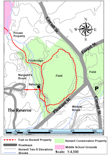
LOCATION: The Donovan Fields property is a 150-acre site at the intersection of Circuit Street, Forest Street and Pleasant Street.
DIRECTIONS and PARKING: From Route 123 east, turn right onto Circuit St. Proceed 0.4 mile to intersection with Pleasant St. Parking area is just beyond the intersection on the left hand side of Circuit St. Parking area can hold about 10-15 cars. If turning onto Pleasant St., there is street parking for 2 cars 0.1 mile from intersection. An old root cellar and gate mark the entrance from Pleasant St.
A Conservation Commission sign, erected in one of the fields marks the property. The fields are leased for agricultural purposes.
TRAIL DESCRIPTION: The trail leaves from Pleasant St. by the root cellar. It travels along the west side of a field and Margaret Brook to an old ponding area with the remains of an old earthen and stone dam. A short spur leads to private residences in The Reserve. Another path from the northwest corner of the field parallels Margaret Brook for a bit. Eventually the trail crosses the brook via a bridge which was Bill Shanley=s (Troop 66) Eagle Scout project. This trail traversed a small section of private property and walkers need to respect this private property. One can also walk the perimeters of both fields.
TRAVEL TIME: 30-45 minutes for a leisurely walk
AMENITIES: Benches were installed along the trail by the old pond as part of Kevin Campbell=s (Troop 66) Eagle Scout project.
ADA ACCESSIBILITY: There is one handicap-accessible parking space in parking lot. Trails are not accessible at present.