Southside posting areas map
This page is for information pertaining to the Southside. (If you would like to change the boundaries, please let me know by e-mailing me.)
Click on the maps below to show a better view
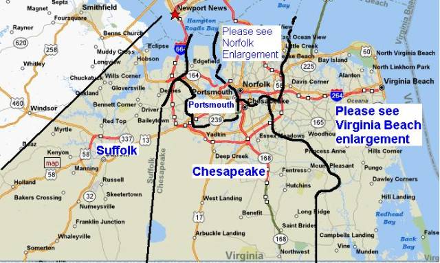
![]() The boundaries
on the Southside can be tricky to understand. First
of all, Portsmouth is small, so it is not divided into
sections, and has its own listing.
The boundaries
on the Southside can be tricky to understand. First
of all, Portsmouth is small, so it is not divided into
sections, and has its own listing.
![]() While
Chesapeake and Suffolk seem large, it is not necessary
(at this time) to divide them into sections, so they have
one listing as well. (If you wish for Chesapeake to be
divided into sections, such as North, South, East, West, let
me know).
While
Chesapeake and Suffolk seem large, it is not necessary
(at this time) to divide them into sections, so they have
one listing as well. (If you wish for Chesapeake to be
divided into sections, such as North, South, East, West, let
me know).
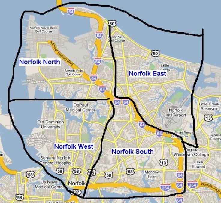
![]() An enlarged
map of the cities of Norfolk and Virginia Beach are shown
below. Boundaries have been marked on the maps to
illustrate how the city is broken up on the site.
An enlarged
map of the cities of Norfolk and Virginia Beach are shown
below. Boundaries have been marked on the maps to
illustrate how the city is broken up on the site.
Norfolk Enlarged Map
![]() Norfolk has
been divided into four sections: North, South, East, and
West.
Norfolk has
been divided into four sections: North, South, East, and
West.
![]() The Boundary
for the North section is everything west of Tidewater
drive from Ocean View Ave to I-64. The southernmost point
in the section is the Lafayette River. This
includes the Norfolk Naval Base (I will try to get the
naval base added as a separate section of Norfolk).
The Boundary
for the North section is everything west of Tidewater
drive from Ocean View Ave to I-64. The southernmost point
in the section is the Lafayette River. This
includes the Norfolk Naval Base (I will try to get the
naval base added as a separate section of Norfolk).
![]() The boundary
for the West section is everything west of Tidewater
Drive from I-64 to the intersection at I-264. This
includes the area around Old Dominion University and
Downtown Norfolk.
The boundary
for the West section is everything west of Tidewater
Drive from I-64 to the intersection at I-264. This
includes the area around Old Dominion University and
Downtown Norfolk.
![]() The East
section of the Norfolk Area is anything East of the
boundary of Tidewater Drive from Ocean View Ave to I-64,
and runs parallel to I-64 to the Virginia Beach/Norfolk
city line. This area includes the Norfolk Airport.
The East
section of the Norfolk Area is anything East of the
boundary of Tidewater Drive from Ocean View Ave to I-64,
and runs parallel to I-64 to the Virginia Beach/Norfolk
city line. This area includes the Norfolk Airport.
![]() The South area
of Norfolk is anything east of a boundary of Tidewater
Drive from I-64 to I-264. The northern boundary
runs parallel to I-64 to the Virginia Beach/Norfolk city
line, and the southern boundary runs parallel to I-264 to
the Interchange with I-64.
The South area
of Norfolk is anything east of a boundary of Tidewater
Drive from I-64 to I-264. The northern boundary
runs parallel to I-64 to the Virginia Beach/Norfolk city
line, and the southern boundary runs parallel to I-264 to
the Interchange with I-64.
Virginia Beach Enlarged map
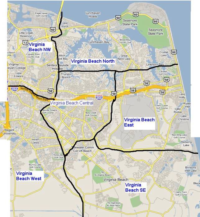
![]() Virginia Beach
is broken into six sections: Northwest (NW), North,
Central, East, West, and Southeast (SE).
Virginia Beach
is broken into six sections: Northwest (NW), North,
Central, East, West, and Southeast (SE).
![]() The NW section
is anything west of boundary of Northampton Blvd to
Independence Blvd, then runs south along Independence
Blvd to the interchange with I-264. The southern
boundary is parallel to I-264. This area includes
the Little Creek Amphibious base.
The NW section
is anything west of boundary of Northampton Blvd to
Independence Blvd, then runs south along Independence
Blvd to the interchange with I-264. The southern
boundary is parallel to I-264. This area includes
the Little Creek Amphibious base.
![]() The boundary
for the North section is anything east of Northampton
Boulevard to Independence. The southern boundary is
a line connecting Independence Blvd to Atlantic Ave.
This includes the Northern part of the Oceanfront to 42nd
St, Seashore State Park, and Fort Story.
The boundary
for the North section is anything east of Northampton
Boulevard to Independence. The southern boundary is
a line connecting Independence Blvd to Atlantic Ave.
This includes the Northern part of the Oceanfront to 42nd
St, Seashore State Park, and Fort Story.
![]() The Central
portion of Virginia Beach is anything east of
Independence Blvd to Baxter Rd, and runs along Princess
Anne Rd to Salem Rd, and Runs along Salem Road to S
Independence Blvd. Then, it runs North along
Independence to Lynnhaven Pkwy, and runs up to the
southern Boundary of the North section. This
includes Pembroke Mall, Lynnhaven Mall, The Sportsplex,
and the Amphitheater.
The Central
portion of Virginia Beach is anything east of
Independence Blvd to Baxter Rd, and runs along Princess
Anne Rd to Salem Rd, and Runs along Salem Road to S
Independence Blvd. Then, it runs North along
Independence to Lynnhaven Pkwy, and runs up to the
southern Boundary of the North section. This
includes Pembroke Mall, Lynnhaven Mall, The Sportsplex,
and the Amphitheater.
![]() The East
Boundary Runs along Lynnhaven Pkwy to Holland Rd, and
Holland Rd to Dam Neck Rd. Then runs along Dam Neck
Road to the Oceanfront. This includes NAS Oceana,
but I can have a separate area made for the Oceana base.
Hilltop and the Oceanfront from 42nd St to
Camp Pendleton are also part of the East section.
The East
Boundary Runs along Lynnhaven Pkwy to Holland Rd, and
Holland Rd to Dam Neck Rd. Then runs along Dam Neck
Road to the Oceanfront. This includes NAS Oceana,
but I can have a separate area made for the Oceana base.
Hilltop and the Oceanfront from 42nd St to
Camp Pendleton are also part of the East section.
![]() The SE
Boundary is anything east of Salem Rd south of S
Independence Blvd. The northern boundary is
anything south of Dam Neck Rd. This includes the
Sandbridge area of the city.
The SE
Boundary is anything east of Salem Rd south of S
Independence Blvd. The northern boundary is
anything south of Dam Neck Rd. This includes the
Sandbridge area of the city.
![]() The West
section of Virginia Beach is anything south of I-264 to
Independence and anything west of Independence and Baxter
Rd. The boundary then runs south along Princess
Anne to Salem Rd. Then the boundary runs South
along Salem Rd to the state line. The westernmost
boundaries are the borders of Chesapeake and Norfolk.
The West
section of Virginia Beach is anything south of I-264 to
Independence and anything west of Independence and Baxter
Rd. The boundary then runs south along Princess
Anne to Salem Rd. Then the boundary runs South
along Salem Rd to the state line. The westernmost
boundaries are the borders of Chesapeake and Norfolk.
I apologize if the boundaries sound confusing, but it seems to make the best geographical sense on the map. Hopefully it will make sense and we can properly classify stations in these areas. If you have any questions feel free to email me.