Rivers of Russia
All rights reserved. Unauthorized use for commercial purpose is strictly forbidden.
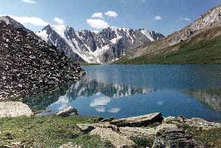
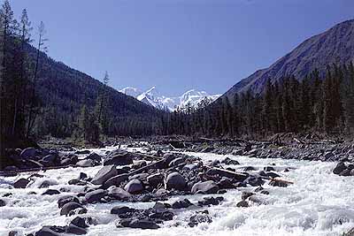
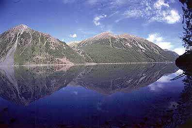
ALTAI Mountains
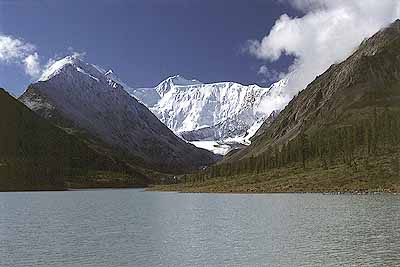
Located in Southern Siberia, near China, Russia and Mongolia border crossing. Highest peak -- mount Belukha: 4506 m.
Best time to visit - July/August.
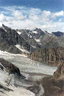
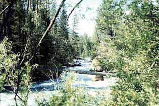
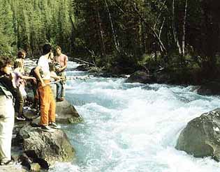
Fly in from Moscow to Barnaul, then one day bus/car or a helicopter. Typical alpine scenery: high mountain areas covered by snow through al summer, valleys are thickly forested with fir and larch trees, high green lawns with wild flowers, dozens of beautriful lakes. Highly recommended for those who are in search of a true wilderness and isolation: this waste mountain area is little populated; people might be not encountered through the days of jorney.
Hints:
For effective interaction with locals esp. when hiring trucks, caterpillars and horses, bring 100% alcohol which will guarantee a 100%-success.
There are no bugs, flies or parasites in late summer.
Try to negociate transport from the airport to the mountains in advance - it is the long journey.
Bring food and everything nacessary to be self-supported along the whole trip. Even bread is hard to get in distant settlements.
In the mountains you can drink water from any streams, or from the rivers, especially after rapids.
If you know fishing, bring the rod.
Wood for fire is everywhere except high lawns. However I advise you to bring gas equipment for the case it is raining.
Small glacier rivers might fluctuate in volume during the day. If there was raining for an extended period of time before you arrived, the big volume rivers might get deadly, so check with locals before making final logistical steps.
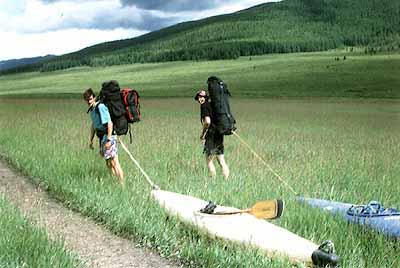
Sometimes at the final stage of the access to the river you have chosen something might go wrong, and you will have to carry your kayak wourself. Tow it on the rope on the grass, or ask a friend to tie it with you to your backpack for the boat ends. Or take a more convenient river...
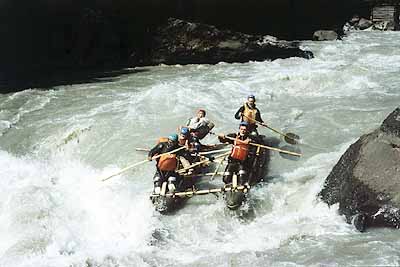
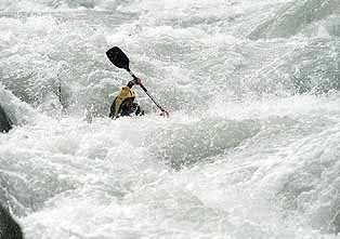
The main rivers
Katun
WW Class: 3
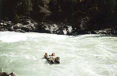
Access and logistics: easy access to middle part - 1 day bus from Barnaul, more difficult to upper reaches - AWD from Ust-Kamennogorsk (Kazakhstan) River description: big volume blue river with bouncy rapids; big playing waves; lower part is away from the road, there are a few gorges with 'funny' water. Total days on the water: approx. 10.
Chuya
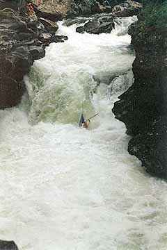
WW class 5
The easiest river to access - the 'Chuyskiy trakt', the main road from Novosibirsk to Mongolia is along the river almost for the whole lenght.
The valley is dry and arid, the river is gray-brown. It originates in a broad bassin called Chuyskaya Steppe - high desert where people grow camel and sheep. Chuya collects many small streams before leaving the steppe already as a relatively big volume river. There are a few easy rapids before it enters a 10-km gorge called 'Majoy cascade'. The old unfinished dam is the last place where you can leave the river if you are running the upper part and don't want to take challenge of extremes in Majoy cascade.
If the water level is not high you can try running Majoy cascade but beware: it starts with nice easy slalom water but then suddenly enters a deep canyon with vertical walls and a dangerous 5-step rapid 'Praesidium' - this is the beginning of second half of the gorge which has plenty of difficult and nasty looking spots. Don't go there in high water. After Majoy Chuya again joins the road and flows for another 100 km and through several 4 or 5 local but very powerful rapids -- probably better choice for big rafts rather than for kayaks, especially in higher water conditions.
The trip can be originated from the Aktash village - after Majoy cascade, and continued afterwards on Katun river. It will take you 3 to 4 days running Chuya from that spot and 3 to 5 relaxing days on Katun with a few nice 'play-the-wave' rapids; count on 3-4 days for the Majoy only.
South-West of Chuyskiy trakt
 Argut
Argut
WW Class 5(6)
A powerful dangerous river with white color of water.
Upper part is called Djazator - no rapids for some 150 km - hilly steppe in a broad valley with Kazakh and Mongolian nomads. Then the river falls through 'Karahem break-through', a 6-7 km deep canyon which is normally unfeasible. A few crazy Siberian tried it in a craft called 'bublik' (bagel/doughnut), which cannot be flipped upside down; and as far as I know, lost it in the middle of the canyon; other 2 attemps were made by catarafts - only the last part was run, one died. The canyon has steep rocky and foresty sides, an enormous decline and huge volume of water, so don't even think of running it. It is interesting as a natural monument.
From 'Karahem break-through' and confluence with Karahem (highly recommended) mighty Argut flows for another 100 km of heavy class 5 rapids, some of them really nasty, but runnable (in normal water condition). There are no settlements for the whole part, you have a feel of absolute isolation; the scenery is gorgeous, especially in deep rocky canyons before the confluence with Shavla (WW 4).
After Shavla - easier, but still demanding 30 km till the confluence with Katun. One of the last rapids 'Behemot' is infamous with a numerous toll of deaths of rafters through the years - those who usually run easier and smaller Shavla and are not prepared for the power and danger of big Argut.
Kara-Alakha
WW class 4
Kara-Alakha is a small volume kayaking river, clean and nice. It is about 30 km long with one rocky canyon with several small waterfalls. Originates near Mongolian border, very distant, the access is a pain in the neck. Kara-Alakha is tributory to Ak-Kalakha.
Ak-Kalakha
WW class 4-5
Ak-Kalakha is a gray river, more powerful than Kara-Alakha. There are several powerful rapids along 40 km till the confluence with Djazator. From there the river bears the name Argut. Access is difficult as well - you should regard it as a true expedition. Coming to Argut you will have to carry Karahem Breakthrough - 5-7 km. The rest of Argut is very hard but feasible, see above.
Karahem
WW class 4(5)
Water is white. Days on the river: 3-4.
Right tributary of Argut. Highly recommended for expert kayakers.
Access by car up to the pass plus about 10 km down by feet or horses. 3-4 days of difficult but highly satisfying kayaking - from technical slalom in the upper river to heavy water in middle and lower parts. The culmination is middle stretch beginning with a land-slide-formed rapid near the right small tributary. The stream leads up to the lake in about 3 hours walking.
Upper Karahem flows in a deep foresty valley from where you can walk up to visit beautiful lakes under snowy South-Chuysky range; running the lower part you see jagged snowy peaks of North-Chuysky range. The trip is continued down the Argut river. From the confluence you can walk to take a look at Karahem break-through a few km up.
Yungur
WW class 4-5
Small volume clean Kayaking river offering 30-35 km of enjoying paddle
similar to Shavla (see below), but the access is more difficult. Joins
Argut in a beautiful gorge 10 km up from Shavla.
Shavla
WW class 4
Water is brilliant clean. Days on the river: 3-4. A very obvious choice for tourists through the years.
Shavla is a superb small volume kayaking river offering 50 km of very continuous whitewater - almost no flat sections. Runs in a thick forest.
Access is to Aktash, then a caterpillar to the pass and by horses and feet to the river - about 20 km. One of the most beautiful areas in Altai Shavlinskiye lakes - are in half a day up from the usual put on. That is definately the place you would want to get to - the lakes under snowy peaks are just gorgeous.
There is one notable rapid Uygur in the upper part - more like a rocky filter; and another one - the lower part's rapid of Neustroyeva - a hard class 5 100-m flush.
Shavla is tributary to Argut - beware its power and wild character. 30 km brings you to Katun and the Whitewater museum on the confluence. The road is in several hours down the Katun.
North-East of Chuyskiy trakt
Chulyshman
WW class 5
The best whitewater for the whole lenght, so different and tempting, a true pearl of Altai.
Water is transparent. Days on the river: 5 or more.
The access is not easy but not the most difficult among the other rivers. You drive along the Chuiskiy trakt to Aktash, then leave the trakt and head to the village Ust-Ulagan, which is located on the bank of Bashkaus (see below), then go up Bashkaus, and over the pass (under 2000m) to a neighbouring valley of Chulyshman. In 1994 our truck got stuck in mud before the pass, we hired a caterpillar to bring our boats and stuff over the pass. Next muddy spot stopped the caterpillar as well. So we proceeded by feet towing the kayaks on a rope on grass, and carrying. Since there is a village Yazula down on the Chulyshman, which is linked to the outside world by this road only, there is a hope that the road is improved by now (not necessarily though).
Another approach is go with horses from Chuyskaya valley, village Kosh-Agach. Some 30 km of high hills will bring you to really wild and isolated places. Chulishman starts from a rather big lake in marshes with floating islands. From there it is about 40 km down to Yazula village, rated not difficult till the stretch described below.
Of course you can hire a helicopter as well.
You can start from Yazula, but hire locals with horses and go up the river another 10-15 km - it will be the most exciting whitewater experience - Yazula gorge. Good class 4 to 5 rapids go one after another, and there are 3 waterfalls for amateurs: Devil's bridge (3 drops - 2, 2 and 4 m consequently); three Vovas (6 m); Vint (Screw, very powerful - 4m). The last stretch is in deep gorge with numerous drops and rapids.
After Yazula Chulyshman is flat for about half a day. Right tributary Shavla (a different one from that I describe below) is a sign of 6-8-km Shavla gorge. It starts with nice whitewater getting more and more difficult. This is already a much bigger water than in the upper parts. The culmination is 2 last km with a notable rapid and very continuous hard whitewater after that. When you see a big cross on the left bank - in memory of several rafters who drowned here in a spring flood some years ago - it means there is the end og gorge behind the turn.
Another flat section (several hours) is bringing you to the most difficult 5-km stretch called Kasha (Porridge). This is definately hard class 5 whitewater with 5 or 6 distinguished spots. Actually, it is one very BIG and continuous rapid. We ran it, but if you're not sure, better give it up and portage.
Below this point there are some other rapids including Tudanski cascade, but these are all generally easier than previous.
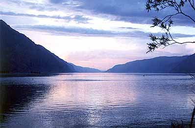
After Chulcha ( go to look at waterfalls 10 km up) joins from right - there is a full day of flat water to the beautiful big lake Teletskoye - the biggest in Altai. Try to catch a boat to the other side (about 3 hours), the road back to civilization is only there.
Bashkaus
WW class 5
Water is transparent. Days on the river: 6 or more.
Probably the most challenging river in the area, subject of many stories and legends.
It is absolutely stupid to run it in high water level. If you are lucky with that you probably will have to portage some of the rapids. Almost all of them are located in a deep 25-30-km gorge, some - very nasty looking. All have been run by rafts and katarafts. Kayaking descents have been rare on this river and everyone is an epic legend.
For the access use guide for Chulyshman. You can start from Ust-Ulagan, or try yourself in a short canyon 10 km up from the village - WW 4. Be aware that from Ust-Ulagan Bashkaus flows in a deep valley with no roads or villages. The gorge starts some 30 km of flat water down from Ust-Ulagan, so if at a certain point you decide not to proceed, you will have to undertake a difficult journey over the pass to a closest village Ko in Chulyshman valley. Many have done that.
Bashkaus joins Chulyshman near Teletskoye lake.
Chebdar
WW class 5-6
An extreme hard small volume river with terrible gorges. Access is only by feet, very difficult, unless it is a helicopter. Absolute wildertness with only forests and mountains around. Joins Bashkaus near Teletskoye Lake.
Has been run by 'Bubliks'.
Chulcha
WW class 5
Actually, this river is not difficult in the whole except the 5-km stretch of continuous waterfalls 10 km before it tributes to Chulyshman. Access is difficult. Has been run by 'Bubliks'.
Akkem
WW class 5
Water is chalk white. Lenght is about 40 km. Originates from Akkem lake under mount Belukha (White mountain) (4506 m) and is tributary to Katun.
I don't know anyone who ran it. I was walking along it and could say it is nice but hard kayaking river, although I have not seen the middle part. I believe it has some potential danger judging the noise I heard from the trail. It would have been a really demanding first descent, considering that it is not at all easy to get to the put on. However if you do get there it will be very rewarding: the massive white wall of Belukha looms over the Akkem lake. Views are breathtaking, there are numerous small lakes all around, a glacier in a short walking distance.
 Access
is the only problem - 2 hard days by feet and horses over a small pass
and up the river. Or have a helicopter - there is a landing spot on the
lake for a wheather-watch station.
Access
is the only problem - 2 hard days by feet and horses over a small pass
and up the river. Or have a helicopter - there is a landing spot on the
lake for a wheather-watch station.
I can imagine paddling on the lake in a total tranquility, and then
dropping to the bobsleigh run down the Akkem river.
Kucherla
WW class 3-4
Kucherla is tributary to Katun and runs in the neighbouring valley west to Akkem. There is a very beautiful big lake from where the river originates; farther up there are more smaller ones in gorgeous rocky mountains. Access is up along the river - about 40 km.
River is clean, small and not very difficult.
Kuragan
WW class 4
Next vally to the West. Sorry, I have no information. Probably similar to Kucherla but offers more lenght.
Kazakhstan
This area is across the range Katunskiye Belki. You can access that region by car from Ust-Kamennogorsk (1 day).
Rivers are:
White Berel and Black Berel - tributaries of Bukhtarma - big river flowing to China territory. Both are WW 3-4 and hardly are worth of complicated logistics, unless it is a special interest. Source of Belaya berel are glaciers in of Southern walls of Belukha. Yazevoye lake 15 km from the peak is the annual gathering place for Roerich sect.
Kaldjir - Small river with a few waterfall originating from a big lake of Markakol
Special Thanks: to Oleg Golovkin for offering his companionship in exploring the rivers; Denis Osin.
Other regions to follow:
Caucasus; Baikal region.
Next update February 15, 1998
Your contribution is highly welcome.
���� ��� �������� ����� ���������� �� ����� � �������������� �������� �� ����������� �����. �� ����������� �� ����������.
Suggestions, questions and feedback is welcome at: