A
Short Local History
of
Ballymun
(No reproduction of this work, in whole or in part, in
any format, is allowed without the express permission of the author)
Wandering through Ballymun it is hard to visualise anything
of its history before the 1960’s. There
are one or two buildings remaining and perhaps the odd road, marking a boundary
between landholdings. Yet Ballymun is situated between the three ancient
villages of Santry, Glasnevin and Finglas.
By examining historical documents it is possible to build up a picture
of life in Ballymun before the building of the Dublin Corporation housing
estate. The aim of this short historical geography is to present a taste of the
sources available for the study of the history of Ballymun before the 1960’s
and to reconstruct a view of Ballymun presented in these documents.
Geographically, the original landscape in Ballymun was
boring. The soil cover consists mostly
heavy clay, and in some places, sands and silts underlain in places by
carboniferous limestone which is 350 million years in age. There are traces of Boulder Clay deposited
during the last glaciation which ended about 12,000 years ago. However the constructtionof the estate
disturbed much of the soil cover so that in places, the original soil cover was
removed, and in others it was buried by excavated soil. Rainfall levels in Ballymun have been
increasing since the 1960’s. In 1962, 654.2 mm of rain were recorded, while in
1998, 832.4 mm of rainfall were recorded.
The surface of the land was relatively flat and sloped
gently from the North East at what is now Poppintree to the South West. The drop in altitude between Poppintree and
The Library on Ballymun road is between 25 and 30 metres. The significance of this slope is that
Ballymun is the location of the sources of numerous streams and rivers, most
notably the Wad River. The fact that
Ballymun is the source of these streams means that the water table was always
close to the surface and therefore the landscape surrounding the rivers was and
remains marshy due to the gentle slope.
The area between streams was relatively well drained soils. The Wad River rises in Poppintree at the
road between the housing estate and the IDA industrial estate. When the
Poppintree estate was built, the construction of the houses was constrained by
the presence of these branches of the Wad River. This River flows down through Ballymun and along the southern end
of Poppintree Park before flowing off along Ballymun Road to the Tolka
River. Also flowing through Poppintree
Park is the Claremont Stream which joins the Wad River. Both of these streams have been culverted,
that is, made to flow through articficial concrete channels. Due to the culverts, these rivers cannot
expand naturally during flood periods and therefore flood in places where there
is bare land. If you ever played soccer on Poppintree Park in the rain you will
be very familiar with this.
On the other side of Ballymun, in Coultry and Shangan,
there are more streams however these are also branches of the Wad River. Two of the branches of the Wad flow around
and enclose Coultry Park. In deed, the
8 storey flats on Coultry Road mark out the banks of one of these
branches. Since Ballymun is the
location of the sources of these streams, any construction on the lands there
must provide for adequate drainage in order to prevent flooding at a later
date. Residents in Sillogue and
Balcurris Gardens know this only too well.
During winter or whenever there is a few hours rainfall, the drains
cannot cope with the amount of water they receive. The Wad river, into which rain water drains, backs-up in the
drainage pipes (which are inadequate) and flooding occurs around the drainage
shores. In addition to this, the
construction of the houses in the 1960’s resulted in localised subsidence that
occurred later and so rain tends to gather in ‘hollows’ around some of the
houses.
Naturally, very little is left of the original
landscape. However Santry Woods provides
a good model of the natural condition of the landscape. It contains the some of the same soils, it
has a river (for the moment) and numerous trees (although many of these were
planted in the 18th and 19th centuries. Why not visit it.
There
is little evidence to suggest major settlement in the area of Ballymun in the
Neolithic period (New Stone Age).
However there are some historical monuments and these are recorded in
the Sites and Monuments Record (SMR). There
are a number of enclosures which are either overgrown or buried (as at
Balcurris and Ard na Meala). More than
likely these are pre-Christian or early Christian age enclosures. These enclosures were circular farmsteads in
which a house would have stood and which may have been surrounded by a wooden
fence or palisade. Any development at
the location of these monuments is required by law to be excavated prior to
construction.
Before
the arrival of the Anglo-Normans in Ireland in 1169, Ireland was divided into a
series of landholdings called tuaths.
Each tuath was held by a Gaelic family or sept. The area of Ballymun was held by the
Gaelenga sept. Nothing remains of this
sept except perhaps the possibility of a connection with St. Pappin after whom
the Church of Ireland church of St. Pappan in Santry Village is named. It is known that this was an early monastic
site prior to the arrival of the Anglo-Normans. The presence of the important nearby monastic settlement of St.
Mobhi in Glasnevin indicates that the area between the two villages was home to
a community.
The
Anglo-Normans invaded Ireland not only on the invitation of Dermot MacMurrough
but also with the purpose of reorganising the church in Ireland. Until the twelveth century the church in
Ireland was organised on the basis of monastic centres or monasteries. The rest
of Europe developed a parochial organisation with a network of small
parishes.
The
first task the Anglo-Normans undertook in reorganising Ireland was to divide
Ireland into Baronies. Ballymun is
situated in the Barony of Coolock. One
or more Baronies were then granted by the Henry II to his favourite knights. Coolock was among the lands granted to Hugh
de Lacy.
Baronies
were then divided into parishes and each was assigned a parish church. Ballymun was in the Parish of Santry. Baronies were also sub-divided into smaller
holdings by the lords or knights to whom they had been granted. In rare cases, a whole parish was granted to
a single individual. This happened in
the case of Santry which was given to Adam de Phepoe (an analysis of a Latin
text with this name would seem to suggest that this name has been incorrectly
translated in the past however the name is generally recognised by Irish
medieval historians).
Parishes
were often further sub-divided as landholders leased out land from which they
could earn rents. This further subdivision led to the development of a townland
network. Ironically, the map of
townlands shows that Ballymun is not in Ballymun! Rather the housing estate of Ballymun was built in the townlands
of Stormanstown, Balbutcher and Balcurris.
The townland of Ballymun is north of the estate and contains Geraldstown
House. Coultry, Shangan and Sandyhill are further north again.
Generally,
as lands were leased by the Anglo-Normans, the name of the area changed. Irish placenames referred to natural
features or local habitats such as a grove of trees or a hill. The Anglo-Normans however gave personal
names to their lands. Hence Ballymun is
either Munn’s Town (Anglo-Norman, except no trace of this person remains) or
Town of the Shrubland (Irish and more likely the correct name).
The earliest references to Ballymun are contained in the collection of Domville Papers held in the National Library Manuscript Department. The deeds date from 1306. The deeds contain details of leases of the lands of Santry to various individuals although in some cases the deeds are fragmented. The leases were sold for a period of years the most common of which was 31 years. However often leases were sold for a period of the life of the leaseholder or lives of him and his heirs.
Occasionally
leases were renegotiated before the expiry date. In many cases the deeds carried conditions such as requiring the
tenant to build a house. In the
eighteenth century deeds particularly required the planting of trees. The effects of this can still be seen to day
in Santry Woods where many of the trees planted in the eighteenth century still
remain. As the population of Santry Parish
increased, so too did the demand for land.
This allowed the landlord to further subdivide his holding and increase
rents. This is evident in the
subdivision of Stormanstown.
The earliest deed contained in the Domville Papers is dated 1306. This deed is actually a will in which some of the lands of Santry were willed to members of the Phepoe (or Seypole depending on translation) family. The forth line contains the name ‘John ffeypolbe de Balymon’.
List of Deeds in the Domville Papers
DATE
|
TOWNLAND |
LEASE NAME |
TERM years |
ACRES |
RENT p/a
£ |
|
1375 |
|
|
|
|
|
|
1586 |
Ballymun
|
|
|
|
|
|
1629 |
Stormanstown Balbutcher |
|
|
|
|
|
1676 |
Balcurris |
Peter Fox1 |
|
160 |
80 |
|
1702 |
Ballymun |
Cambell2 |
|
|
|
|
1702 |
Stormanstown |
R. Lighe |
99 |
100 |
95 |
|
1708 |
Stormanstown |
R. Lindon3 |
|
|
|
|
1736 |
Coultry |
|
1 |
|
|
|
1740 |
Coultry |
William Cooper |
|
|
|
|
1753 |
Stormanstown |
Warren |
31 |
5 |
11 |
|
1754 |
Stormanstown |
John Kelso |
3 lives |
49 |
112 |
|
1757 |
Coultry |
Henry Dillon |
31 |
97 |
96 |
|
1759 |
Stormanstown |
Corbally |
31 |
65 |
150 |
|
1769 |
Coultry |
Henry Dillon |
20 |
99 |
96 |
|
1775 |
Stormanstown
|
R. Allen Thomas Brown4 |
61 |
21 |
|
|
1790 |
Coultry |
Thomas Lynch |
30 |
66 |
188 |
|
1790 |
Stormanstown (part) |
Corbally |
31 |
67 |
185 |
|
1803 |
Coultry |
T. Linehan |
lives |
66 |
227 |
|
1810 |
Balbutcher |
M. Cahill |
3 lives |
25 |
75 (e) |
|
1810 |
Balbutcher |
C. Caghlan |
lives |
35 |
184 |
|
1811 |
Balbutcher |
Daniel Monks |
3 lives |
52 |
260 |
|
1811 |
Stormanstown |
Barret |
Lives |
31 |
280 |
|
1812 |
Balbutcher |
James Tully |
3 lives |
25 |
75 (e) |
|
1818 |
Balbutcher |
James Tully |
3 live |
26 |
134 |
|
1842 |
Stormanstown |
W. Suchinleck |
Lives |
82 |
247 |
|
1845 |
Lands @ Santry lane |
A. Coghlan |
|
140 |
347 |
|
1853 |
Stormanstown |
Barret5 |
|
|
|
|
1872 |
Stormanstown |
Patrick Delany6 |
|
82 |
|
1.
Peter
Fox, Farmer. Lease required him to build
‘a house 40 feet long and built of Lime, stone and timber from fruit trees’.
2.
Sale
of Stormanstown by Dr. Leslie to
Campbell of Ballymun and Sillock.
3.
Assignment
of lease of house and lands of Stormanstown from R. Lighe to R, Lindon.
4.
Deed of
Annuity for the value of £1000 for the house and lands of Stormanstown costing
£100 per annum.
5.
Surrender
of lease.
6.
Surrender
of lease.
(e)
Tenants evicted.
In
the 14th Century, the lands of Ballymun were flat, well drained and
fertile. While centuries of agriculture
eventually took its toll on the soil, the land was well suited to agriculture
and commanded good rents during Anglo-Norman period. The presence of mills at Santry, Finglas and Glasnevin indicated
that the area surrounding the villages were highly productive. This is in keeping with the character of
agriculture in Ireland during the Anglo-Norman period. Cereals, especially wheat was grown and cattle
rearing was also practised. The cost of
living was low and while peace lasted, people enjoyed a standard of living
comparable to other European countries.
This situation continued until the seventeenth century when even areas
inside The Pale experienced the turmoil of the 1641 Rebellion and the
Cromwellian invasion.
After the Domville papers, the next information available on Ballymun comes from the land surveys of the seventeenth century. A rebellion by Irish and Old English Catholics in1641 was suppressed by Oliver Cromwell. To do this Oliver Cromwell needed money and so he offered land in Ireland to investors in the war against the rebels and to soldiers instead of wages. However, in order to redistribute the land, a survey of the land had to be conducted.
The
first survey was called the Down Survey and was carried out by Sir William
Petty. This involved ‘mapping down’ the
land. The Down Survey for the Parish of Santry shows only the townlands of
Coultry with 88 acres and Ballymun with 181 acres. The Down Survey also shows
the presence of a house with a chimney.
Another
more accurate survey of the amount of land in Ireland was carried out. This was called the Civil Survey and
involved a commission interviewing local inhabitants about the lands and
buildings of an area. The entry for
Santry includes the townlands of Ballymun, Stormanstown, Coultry, Balcurris,
Balbutcher and Sillogue. Poppintree,
which belonged to the Parish of Finglas, was not recorded and perhaps did not
exist at the time.
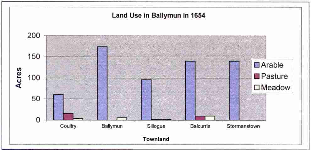
The Civil Survey of 1654 recorded the owners of the land, the number of acres and whether it was suitable for arable or pasture farming, and the value of the land. Various observations were also made regarding the right of ownership of the landholder and whether there were any buildings on the land. The townlands that make up Ballymun contained 660 acres which included 610 acres of arable land. Such a large quantity of arable land is evidence of the ability of the land to produce crops at that time. This was reflected in the value of the land. In the townlands of Ballymun, the average value was £2 per acre. This compares with the average of 5 shillings per acre for Ireland as a whole.
There
were more buildings recorded in the Civil Survey than in the Down Survey.
Thatched
houses 3 Cabins ‘some’
Tiled
houses 1 Orchards 2
Cottages 5 approx. Gardens 2
Name Townland Land Uses (acres) Total Value in Arable Pasture Meadow 1654 £'s James Barnewall Coultry 60 16 4 80 50 Ballymun 174 6 180 100 Sir James Barry Sillogue 96 2 2 100 50 Balcurris 140 10 10 160 80 Stormanstown 140 140 100 Total 610 28 22 660 380
Graph of Land Use Click Here
1659 Census
The 1659 Census records the number of people resident in the area in 1659. However this ‘census’ is really a hearth money return, that is, a list of people paying a tax on the number of fireplaces in their homes. This means that only the named householders were enumerated. Historians have estimated that multiplying the number of people recorded by 2.5 gives a more accurate indication of the number of residents at the time. This would indicate that there was 345 people living in Ballymun at the time of the census. The 60% of the population was made up of Irish people and the remainder were English people. The population density in 1659 was approximately 1.91 persons per acre.
The eighteenth century was a time of peace and prosperity in Ireland. The peace that existed allowed landlords to accumulate vast wealth and to display this wealth by their ‘improving’ nature. Estates were fitted out with a landlord demesne (pronounced ‘demain’), vast areas of land surrounded by a wall containing a large mansion, an ornamental garden and large areas of forest plantations. Agriculturists promoted the breeding of animals and the application of fertilisers to increase agricultural yields. These qualities were passed on by the landlord to their tenants, and were even written into the leases to land. The Barry family built Santry Court, a large mansion and one of the finest in Ireland. The mansion remained intact until after World War II throughout which it was occupied by the Irish Army. Unfortunately it was gutted by a fire and never repaired.
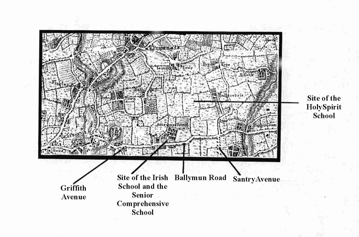
The effect of landlordism on the countryside is evident in estate maps. These maps were produced by mapmakers influenced by the style of John Rocque. This French mapmaker produced a series of maps of Ireland in 1756 showing the countryside divided into neat fields after the fashion of enclosures coming into force at the time. Villages were shown with their buildings and mansion houses were illustrated with their ornamental gardens. The map of Stormanstown shows this quite clearly. Click Here
The eighteenth century also witnessed the promotion of education. This was indicated partly by The Royal Charter of George II in 1733 establishing the Charter Schools in Ireland. In Ballymun a Charter School was opened at the old intersection between the back road to the airport and Santry Avenue. Ballymun House remains largely intact about 200 metres north of this intersection (close to the mobile phone mast and petrol station opposite Sillogue/Naul Park). Click Here
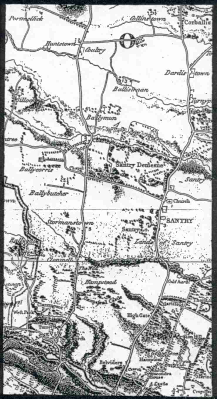
Despite
the peace of the time Highwaymen were common and because the Swords Road was
the main Turnpike Road between Dublin and Dundalk, it was naturally prey to
such thieves. Click Here The
vast forestry plantations in Santry Desmesne at the time provided excellent
cover and the Ballymun Road provided a quick escape route. There are accounts however of pitched
battles occurring over such highway incidents.
Irelands fortunes began to decline after the Act of Union with Great Britain came into force in 1801. This was also the case for the townlands of Ballymun. Very little changed in the area in 100 years although a new mansion was erected in Stormanstown. This house was located where Scoil an tSeachtar Loach is now. Indeed, up until the construction of the Senior Comprehensive School, the cellars remained intact underground. Throughout the 1970’s, the area behind the schools retained traces of the demesne attached to the house. However it was overgrown and unkempt with a variety of plant life. However it also contained pools of water in places that showed the area was poorly drained and marsh-like. A small stream ran along what is now the boundary railing between the Irish school and the end of Sillogue Gardens.
In 1848 the Domville family paid for the construction of a Catholic Chapel in Ballymun in honour of their coachman, James Kelly, who was murdered by one of their family. The heir to the Domville Estate was out drinking one night in the Palmerstown Inn with his friends. Later, the drunken heir and another were been driven home in the family coach when the heir poured whiskey over the coachman and set him alight. Family connections and a great deal of canvassing on the part of the Sir Compton Domville ensured that his son did not hang for the crime. However he did lose his inheritance and was forced into exile on the continent. The coachman is entombed to the rear of St. Pappins Church on Ballymun Road.
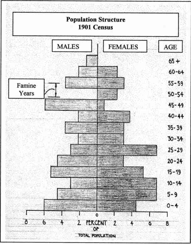
The 1901 manuscript census returns indicate that the famine was harsh in Ballymun. There is a complete absence of males between the ages of 49 years and 55 years. This is the age group born during the years of the famine. The female population in this age group also is also remarkably reduced. However the population of the area recovered quickly as indicated by the population pyramid. Click Here
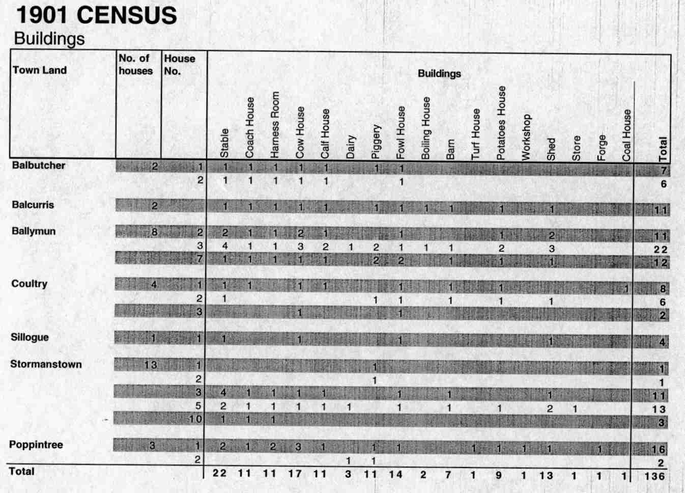
The
1901 census also shows that the area was dominated by agriculture with most
heads of households being either farmers or agricultural labourers. The number and type of agricultural building
also indicates that the area had recovered well from the famine, being able to
re-establish its population. Click Here
That
said however the estate of Santry was much reduced by the sale of land under
the Encumbered Estates Act. This Act of
Parliament was designed to assist landlords in clearing their debts in the wake
of the famine.
The
agricultural character of Ballymun remained until the 1960’s and included among
its owners the Albert Agricultural College (now the site of DCU). However there were large areas of forest indicating
that much of the land had earlier lost its capacity for agriculture.
1960’s
The
1961 census recorded the first net increase in population in Ireland since the
famine. This was particularly evident
in Dublin City were population pressure forced people to live in overcrowded
tenements. A series of building
collapses forced the government into constructing a large number of housing
units to accommodate people.
The
scheme for Ballymun was designed as a quick fix solution to the housing problem
with little consideration for long-term trends. Even in Britain at this time, tower blocks were being demolished
because they were found to be unsuitable for families. In Ballymun however, flat units were in
great demand with prospective residents sitting interviews to determine their
suitability for housing in Ballymun. On
completion, Ballymun was handed over to the Corporation who did not appear to
want the responsibility for the administration of the area. The rest, as they say, is history. Ballymun did not get the services or
amenities one would expect of a suburb of 20,000 people. It became a transition point for families in
search of better accommodation. Social and
economic instability fostered an emerging drug culture. In the absence of on-going proper
maintenace, the poor physical environment compounded the problem. However it is to the credit of Ballymun
people that they banded together in community groups and associations to combat
the cycle of disadvantage that had set in by the 1980’s. This good work continues for the
moment. The future of these groups is
uncertain until the regeneration is complete.
Residents
of Ballymun have learned that a community is built with hard work from the
ground up and not created, as architects would sometimes have us believe. Being a unique place in Ireland, residents
have acquired a unique sense of place, and it is this which has crafted the
community spirit which exists in Ballymun.
As
the suburb of Ballymun faces the millennium, and a face lift, the challenge
will be to maintain a sense of a united community through a changing sense of
place and a changing sense of space within the area.