GPS satellites -- it's
an amazing system! Features tells you
about all of the features you find on GPS receivers so you know what
you are talking about if you are looking to buy one. And so on...
Just click on the different areas of the map to learn all about
these amazing devices!
How It Works
The Global Positioning System
(GPS) consists of 24 earth-orbiting satellites. These satellites
allow any person who owns a GPS receiver to determine his or
her precise longitude, latitude and altitude anywhere on the planet.
For as little as $100, you can know exactly where you are and where
you have been. For anyone who has ever been lost -- while hiking in
the woods, boating in the ocean, driving in a unfamiliar city or
flying a small airplane at night -- a GPS receiver is a miracle.
When you use GPS receiver, you're never lost!
How is this possible?We'll look at the details of how the GPS satellites and GPS
receivers work together to pinpoint a location. You'll find that the
GPS system is an amazing technological tour de force!
Trilateration
In order to
understand how the GPS satellite system works, it is very helpful to
understand the concept of trilateration. Let's look at an
example to see how trilateration works.
Let's say that you are somewhere in the United States and you are
TOTALLY lost -- you don't have a clue where you are. You find a
friendly-looking person and ask, "Where am I?" and the person says
to you, "You are 625 miles from Boise, Idaho." This is a piece of
information, but it is not really that useful by itself. You could
be anywhere on a circle around Boise that has a radius of 625 miles,
like this:
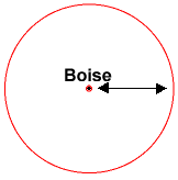
If you know you are 625 miles from Boise,
you
could be anywhere on this circle.
So you ask another person, and he says, "You are 690 miles away
from Minneapolis, Minnesota." This is helpful -- if you combine this
information with the Boise information, you have two circles that
intersect. You now know that you are at one of two points, but you
don't know which one, like this:
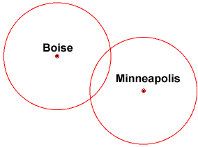
If you know you are 625 miles from Boise
and
690 miles from Minneapolis, then you
know you must be at one of
two points.
If a third person tells you that you are 615 miles from Tucson,
Arizona, you can figure out which of the two points you are at:
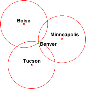
With three known points, you can determine
that your exact location is somewhere near
Denver, Colorado!
With three known points, you can see that you are near Denver,
Colorado!
Trilateration is a basic geometric principle that allows
you to find one location if you know its distance from other,
already known locations. The geometry behind this is very easy to
understand in two dimensional space.
This same concept works in three dimensional space as well, but
you're dealing with spheres instead of circles. You also need 4
spheres instead of three circles to find your exact location. The
heart of a GPS receiver is the ability to find the receiver's
distance from 4 (or more) GPS satellites. Once it determines its
distance from the four satellites, the receiver can calculate its
exact location and altitude on Earth! If the receiver can only find
three satellites, then it can use an imaginary sphere to represent
the earth and can give you location information but no altitude
information.
For a GPS receiver to find your location, it has to determine two
things:
- The location of at least three satellites above you
- The distance between you and each of those satellites
Measuring Distance
Do You Own a GPS???Do you own a GPS? If so,
millions of How Stuff Works readers would love to know how you
like it, and what you think are the best and worst features of
your GPS. !! | GPS satellites send
out radio
signals that your GPS receiver can detect. But how does the
signal let the receiver know how far away the satellite is? The
simple answer is: a GPS receiver measures the amount of time it
takes for the signal to travel from the satellite to the receiver.
Since we know how fast radio signals travel -- they are
electromagnetic waves and so (in a vacuum) travel at the speed of
light, about 186,000 miles per second -- we can figure out how far
they've traveled by figuring out how long it took for them to
arrive.
Measuring the time would be easy if you knew exactly what time
the signal left the satellite and exactly what time it arrived at
your receiver, and solving this problem is key to the Global
Positioning System. One way to solve the problem would be to put
extremely accurate and synchronized clocks in the satellites and the
receivers. The satellite begins transmitting a long digital pattern,
called a Pseudo Random Code, as part of its signal at a
certain time, let's say midnight. The receiver begins running the
same digital pattern, also exactly at midnight. When the satellite's
signal reaches the receiver, its transmission of the pattern will
lag a bit behind the receiver's playing of the pattern. The length
of the delay is equal to the time of the signal's travel. The
receiver multiplies this time by the speed of light to determine how
far the signal traveled. If the signal traveled in a straight line,
this distance would be the distance to the satellite.
The only way to implement a system like this would require a
level of accuracy only found in atomic
clocks. This is because the time measured in these calculations
amounts to nanoseconds. To make a GPS using only synchronized
clocks, you would need to have atomic clocks not only on all
the satellites, but also in the receiver itself. Atomic clocks
usually cost somewhere between $50,000 and $100,000, which makes
them a little too expensive for everyday consumer use!
The Global Positioning System has a very effective solution to
this problem -- a GPS receiver contains no atomic clock at all. It
has a normal quartz
clock. The receiver looks at all the signals it is receiving and
uses calculations to find both the exact time and the exact location
simultaneously. When you measure the distance to four located
satellites, you can draw four spheres that all intersect at one
point, as illustrated above. Four spheres of this sort will not
intersect at one point if you've measured incorrectly. Since the
receiver makes all of its time measurements, and therefore its
distance measurements, using the clock it is equipped with, the
distances will all be proportionally incorrect. The receiver can
therefore easily calculate exactly what distance adjustment will
cause the four spheres to intersect at one point. This allows it to
adjust its clock to adjust its measure of distance. For this reason,
a GPS receiver actually keeps extremely accurate time, on the order
of the actual atomic clocks in the satellites!
One problem with this method is the measure of speed. As we saw
earlier, electromagnetic signals travel through a vacuum at the
speed of light. The earth, of course, is not a vacuum, and its
atmosphere slows the transmission of the signal according to the
particular conditions at that atmospheric location, the angle at
which the signal enters it, and so on. A GPS receiver guesses the
actual speed of the signal using complex mathematical models of a
wide range of atmospheric conditions. The satellites can also
transmit additional information to the receiver.
From this discussion you have learned several important facts
about the Global Positioning System:
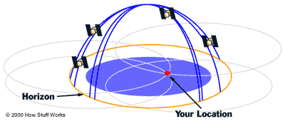
- The Global Positioning System needs 24 satellites so it can
guarantee that there are at least 4 of them above the horizon for
any point on earth at any time. In general there are normally 8 or
so satellites "visible" to a GPS receiver at any given moment.
- Each satellite contains an atomic clock.
- The satellites send radio signals to GPS receivers so that the
receivers can find out how far away each satellite is. Because the
satellites are orbiting at a distance of 11,000 miles overhead,
the signals are fairly weak by the time they reach your receiver.
That means you have to be outside in a fairly open area for your
GPS receiver to work.
Finding the Satellites
The
other crucial component of GPS calculations is the knowledge of
where the satellites are. This isn't difficult because the
satellites travel in a very high, and predictable orbits. The
satellites are far enough from the earth (11,000 miles) that they
are not affected by our atmosphere. The GPS receiver simply stores
an almanac that tells it where every satellite should be at
any given time. Things like the pull of the moon and the sun do
change the satellites' orbits very slightly, but the Department of
Defense constantly monitors their exact positions and transmits any
adjustments to all GPS receivers as part of the satellites' signals.
Finding Location
The most essential
function of a GPS receiver is to pick up the transmissions of at
least four satellites and combine the information in those
transmissions with information in an electronic almanac, so that it
can mathematically determine the receiver's position on Earth. The
basic information a receiver provides, then, is the latitude,
longitude and altitude (or some similar measurement) of its current
position. Most receivers then combine this data with other
information, such as maps, to make the receiver more user friendly.
You can use maps stored in the receiver's memory, connect the
receiver up to a computer that can hold more detailed maps in its
memory or simply buy a detailed map of your area and find your way
using the receiver's latitude and longitude readouts.
Geographers have mapped every corner of the Earth, so you can
certainly find maps with the level of detail you desire. You can
look at a GPS receiver as an extremely accurate way to get raw
positional data, which can then can be applied to geographic
information that has been accumulated over the years. GPS receivers
are an excellent navigation tool, with seemingly endless
applications!
What It Can Do
The Global Positioning System, a
collection of 24 earth-orbiting satellites, has a number of possible
applications, spanning across several areas of society. For most of
us, the way we can take advantage of GPS is to purchase a handheld
GPS receiver, or have one installed in our car. Handheld receivers
are compact, and the most basic ones are fairly affordable. You can
pick one up for as low as $100!
This could certainly be a sensible purchase, when you consider
all of the things a GPS receiver can do for you. The basic function
of a GPS receiver is to figure out its location on Earth. To
everyone who's ever lost their way in the woods, driven off course
on a cross-country trip or gotten turned around while piloting a
boat or airplane, the advantages of this simple function are
obvious. But most GPS receivers go far beyond providing this simple
navigational data. They can act as an interactive map, and they have
a number of recreational applications. We'll look at many of the things you can do with a GPS receiver!
The Basics
At its heart, a GPS
receiver is simply a device that can locate itself on Earth. It does
this by communicating with at least four satellites overhead (see this page for
details). For this reason, a GPS receiver is limited as to where it
can function. It has to be able to "see" the satellites to calculate
latitude and longitude, which means it usually won't work inside.
So, one of the basic characteristics of GPS receivers is that they
find your location only when you are outside.
The simplest GPS receiver would give you just the
coordinates of your location on Earth in latitude, longitude
and altitude. Latitude and longitude are basically X and Y axes of a
big imaginary grid wrapped around the planet, and altitude is a
measure of your distance above sea level. If you had a GPS receiver
that gave you these simple coordinates, and you had a map of your
area that used this same coordinate system, you could find your
location simply by reading the map. In this regard alone, a GPS
receiver is a amazing device. Without a GPS receiver, you would have
to find your position based on the position of the stars in the sky,
using complicated tools and calculations. And you wouldn't have near
the same level of accuracy!
But today's handheld GPS receivers give you much more than this
raw data. Even low-end receivers have some sort of electronic map
stored in memory, so you don't have to carry around a bunch of paper
maps. The receiver takes the coordinate information and applies it
to its electronic map, graphically pointing out to you where you are
in relation to roads, bodies of water, etc. Maps vary a great deal
in the level of detail they offer; but the basic idea behind this
function is to give you a map that automatically marks your
location, without you having to consider your coordinates. This is a
great convenience any time you need to use a map, and is extremely
helpful at times when you can't take the time to find your location
on a map, such as when you're driving down the highway.
GPS in Motion
A standard GPS
receiver will not only place you on a map at any particular
location, but will also trace your path across a map as you move. If
you leave your receiver on, it can stay in constant communication
with GPS satellites to see how your location is changing. If you've
read the article on How a GPS Receiver
Works, you know that a receiver must know the exact time to find
its location. If it combines these two pieces of information -- your
changing location and the exact time -- it can also calculate how
fast you are going. A receiver can use all of this basic data to
give you several pieces of valuable information:
- How far you've traveled (odometer)
- How long you've been traveling
- Your current speed (speedometer)
- Your average speed
- A "breadcrumb" trail showing you exactly where you have
traveled on the map
- The estimated time of arrival at your destination if you
maintained your current speed
To obtain this last piece of
information, you would have to have given the receiver the
coordinates of your destination, which brings us to another GPS
receiver capability: inputting location data.
User Input
Most receivers have
a certain amount of memory available for you to store your own
navigation data. This greatly expands the functionality of the
receiver, because it essentially lets you make a record of specific
points on Earth. The basic unit of user input is the
waypoint. A waypoint is simply the coordinates for a
particular location. You can save this in your receiver's memory in
two ways:
- You can tell the receiver to record its coordinates when you
are at that location.
- You can find the location on a map (the internal map or
another one) and enter its coordinates as a waypoint.
This
capability lets you use your GPS receiver in a number of different
ways. You can record any specific location that interests you, so
that you'll be able to find it again at a later time. This might
include:
- Good camp sites
- Favorite road-side shops
- Excellent fishing spots
- Scenic overlooks
- Where you left your car
You can also combine a series
of different waypoints to form a route. One way to use this
function is to periodically record waypoints as you make a trip so
that you can backtrack, or follow the same route again on another
trip. And route-mapping also lets you plan ahead. When you have time
to examine a map at home, you can record a series of waypoints along
the roads or trails that lead to your destination. Then, when you
are traveling, all you will need to find your way is your GPS
receiver. As you travel, the receiver will show you which way to go
and give you the distance to your next waypoint. All you need to do
is follow its simple directions.
Computer Connections
Receivers
with route capabilities will let you save a certain number of
waypoints to memory so that you can use them again and again. If the
receiver has a data port, you can also download your routes
to a computer, which has much more storage memory, and then upload
them again when you plan to follow those routes.
Because they have so
much more storage capability, computers can do a lot more with GPS
location data than your average receiver. A receiver with a data
port can feed the raw coordinates of your location into a computer
running more complicated software. There are a number of available
software applications that can place you on detailed maps of
particular areas. If you want to use your receiver for complicated
navigation, down backroads for example, this capability will help
you out tremendously. You can also update your computer maps, so
that they include any surveying adjustments or changes in an area,
whereas a receiver's onboard map usually can't be changed. When you
use your receiver in conjunction with your computer, you increase
the receiver's capabilities considerably. Also, your receiver won't
be outdated as quickly, because in conjunction with a computer, all
it needs to do is provide coordinates -- your computer does the
rest.
Some recent receivers let you download detailed maps of an area
into the GPS, or supply detailed maps with plug-in map cartridges.
These maps can give you street-level detail in cities and the
receiver may even provide driving directions as you drive!
GPS receivers have been a favorite of hikers, boaters and pilots
for years, and are now becoming commonplace as prices fall. Check
out the handy feature chart to
help you decide which features you need!
Features
If you are thinking about buying a GPS
receiver, it is helpful to know all of the features that GPS
receivers offer today. That way you can pick the receiver that is
perfect for you. The chart below highlights the most important
features available today:
| Essential |
| Feature |
Option |
Description |
| Receiver |
Multiplex |
Multiplex receivers have only one
channel. They pick up one satellite signal at a time,
cycling through a few satellites. They work much better in
open environments, as their connection can easily be disrupted
by buildings or other obstacles. The most affordable models
use multiplex receivers. |
| Parallel-channel |
Parallel-channel receivers have several
channels, and lock onto many satellites at the same time.
They don't lose satellite connections very easily and they can
pinpoint the location more exactly. These receivers were once
fairly expensive, but there are several affordable models now
on the market. If you plan to use your receiver in a big city
or mountainous area, you should probably get one with parallel
channels. |
| Antenna |
Quadrifilar |
Quadrifilar antennas are a length of coiled
wire in a plastic housing that protrudes from the receiver.
You may want to look for a model with a removable quadrifilar
antenna, so you can place the antenna on your dashboard for a
better "view" of the satellites. Quadrifilar antennas are best
at receiving transmissions from satellites near the horizon,
and not so adept at receiving signals from satellites
overhead. |
| Patch |
Patch antennas are flat, and they are
usually built in to the receiver. They have the reverse
strengths and weaknesses of a quadrifilar antenna: They are
better at detecting satellites that are directly overhead and
not as good at detecting satellites near the horizon.
|
| Power |
Battery |
Hand-held receivers will use batteries as a
power source. This means portability. Be sure to find
out what kind of batteries a hand-held unit uses, and how long
they typically last. |
| External Source |
Some handheld receivers can accept external
power, which is handy if you plan to be driving all day with
your GPS on and don't want to drain the batteries. Car, boat
or airplane in-dash GPS receivers will run on an external
power source provided by the larger unit it's hooked up to.
These devices are not mobile. |
| Display |
LCD Panel |
All GPS receivers display information on an
LCD panel. |
| Color LCD Panel |
These displays make it easier to read
maps on the receiver and help you distinguish between
different routes you have created in the same area. Color
panels often use more power than B&W panels, so they drain
batteries faster. |
| Map Datum |
WGS 84 |
WGS 84 is the default map datum for any GPS
receiver. It is a system developed around the emergence of GPS
technology and is standardized for universal
use. |
| Additional |
Eventually maps of the whole world will be
converted to WGS84, a GPS standard datum. In the meantime,
check to see that the GPS receiver recognizes the map datums
used in your area, or areas you plan to travel
to. |
| Standard |
| Feature |
Description |
| Internal Maps |
All receivers will give you your latitude,
longitude and altitude, but they don't all show you your
location on a detailed map. When you're shopping for a
receiver, decide what kind of map you'll need and make sure
the receiver you purchase offers that type of map. Many
receivers contain a general map for the world in memory, but
this map may only show you major roads and bodies of water.
Some receivers have a wide array of other maps stored in
memory or can download detail maps. |
| Map Cartridges |
Some receivers accept special map cartridges
with more detailed maps of specific areas. |
| Download Maps |
Some of the newer GPS receivers have
download capability that allows you to download maps stored in
your computer into your receiver. |
| Way Point Capability |
With this feature, you can record certain
way points -- locations along your path or on a map --
and arrange them in a route. Your receiver will then guide you
from way point to way point along your route. This route
mapping is handy because you can record the way you got
somewhere so you can easily backtrack. You can also plan
routes on detailed maps before you leave for a trip, and
record all the information you need on your hand-held
receiver. |
| Track Logging |
Receivers with a track logging feature can
record your path as you move. This is useful if you want to
backtrack or document your exact route for future use. It's
also helpful to view your progress this way while you are
traveling. |
| Storage Memory |
If you plan to use route-mapping and track
logging extensively, you'll want to find a receiver that has
enough memory. Consider how many way points you would want to
store and find out what a receiver's maximum storage
capability is. Also, look for a receiver with a backup system
that will hold onto your information while you change the
receiver's batteries. |
| Data Port |
One way to place yourself on a detailed map
is to hook the receiver up to a computer (desktop, laptop or
PDA). A data port provides such a connection so that you can
use GPS data in conjunction with a number of software
applications. Receivers with computer connection capability
may also be able to download information to the computer. This
is a good feature if you want to keep a collection of route
maps (favorite hiking paths, tricky driving directions, good
fishing spots). A receiver has limited memory, but you can
store an entire catalog of route maps on your
computer. |
| Sunrise/Sunset Times |
Some receivers can give you the times for
sunrise and sunset at any particular location. This helps you
plan your trip so you don't have to travel in the dark, which
can be very useful to hikers, sailors, and pilots
alike. |
| Odometer |
In most modern receivers, you can track how
far you have traveled. Just like the odometer in your car,
this feature can be useful in any number of ways.
|
| Speedometer |
Most GPS receivers these days can track how
fast you are moving. This is extremely helpful for estimating
how long it will take you to get to your destination. Most
receivers with speedometers will also give you an ETA.
|
| Measurement Units |
Make sure a receiver can display the
measurement units you will be using. If you will use the
receiver in sailing navigation, for example, you will probably
want a receiver that can give you measurements in nautical
miles. Another feature to look for is the ability to display
multiple measurement systems at a time, so that you could have
elevation in feet, say, and geographical distance in
kilometers. |
| Accuracy Warning |
Most receivers have some sort of system that
tells you when something may be causing inaccurate
positioning. This could either be due to poor satellite
reception or to a receiver malfunction. In a lot of GPS
applications, accurate positioning is critical, so be sure to
find a receiver that will tell you when there is an accuracy
problem. |
| Extras |
| Feature |
Description |
| Differential GPS |
Differential GPS is a technique that
utilizes a second GPS receiver at a known location to correct
for satellite signal inaccuracies. If a receiver already knows
its exact location, it can check the accuracy of the signals
it is receiving. This second, stationary receiver then
broadcasts any accuracy adjustments to your
receiver. |
| Built-in Database |
GPS receivers designed specifically for
airplanes or boats may have way points, or landmarks, already
programmed into them. These might include airports and ports.
|
| Rotatable Screen |
Some GPS receivers have a display that
rotates from a vertical position to a horizontal position.
This feature might be useful if you plan to mount your
receiver horizontally in your car some of the time and carry
it vertically in front of you at other times. |
| User-changeable Fields |
Receivers with this feature give you some
extra control over how you look at information. Basically, you
can customize different fields so they show you only the
information you need for a particular activity. |
| Waterproofing |
If you will be using GPS on a boat or while
hiking, you should look for a receiver with good
waterproofing. Some receivers are sealed so that they are
completely waterproof while others are merely constructed so
they resist water. Consider the conditions in which you will
be using your receiver, and look for an adequate amount of
weatherproofing. |
Some GPS receivers
have speed limits.
GPS receiver manufacturers sometimes
program speed limits into the devices, so that if the device
is moving above a certain speed, it will not work properly. A
receiver meant to be used in a car
may not work on an airplane, which
travels much faster than a automobile. This is more often the case
in car, airplane or boat-mounted receivers than in the hand-held
models.
GPS receivers have temperature limits.
Like most
electronic devices, especially those with LCD screens, GPS
receivers may not function properly above or below certain
temperatures. If you plan to use your receiver in any extreme
temperature situations, such as mountain climbing or hiking in the
desert, you should check to make sure the receiver model can
function in those conditions.
|