Ya' a' te' eh!
This means 'hello' in the Navajo language. My name is John Lowe and I am a
member of the Great Navajo Nation of Arizona, New Mexico and Utah. My clan is
Red House Clan (Kin' lichii' nii) born for the Salt Clan (Ashii' hi) and I was
born at Fort Defiance, Arizona (Fort Defiance in the Navajo language is: Tse'
hootsooi [Meadow in Between the Rocks]). We call ourselves Dine', it means: The People. This is my homepage and I want to share with you my culture and heritage for I am VERY proud of it. I am proud of my people and my elders for passing on the Dineh culture for many centuries...
Navajo legends tells that the Dineh had to pass through four different worlds
before entering into the present world - The Fifth World. Since the beginning,
Navajos believed there are two classes of beings: The Earth People and The Holy
People. The Earth People are ordinary human beings, while the Holy People are
higher beings that cannot be seen.
THE FIRST WORLD was red in color and this world was an island, surround be
oceans. On this world, lived the Insect People: Dragon Flies, Red Ants, Black
Ants, Red Beetles, Black Beetles, White Faced Beetles, Yellow Beetles, Hard
Beetles, Dung Beetles, Bats and Locusts and White Locusts. The Insect People
sinned in the First World and were cast out by the Four Gods of the Insect
People. They refused to leave so the Gods caused a huge flood. With no other
choice, the Insect People took flight and flew in circles.
A creature called out to them and told them to enter through a slit in the
eastern sky. They entered THE SECOND WORLD, which was blue in color. The
creature belonged to the Swallow People (cliff swallow). The Swallow People and
the Insect People lived in harmony for 24 days until one of the Insect People
sinned with one of the Swallow People. The Chief of the Swallow People
discovered the wrong. He commanded the Insect People to leave their world. So
they took flight in the sky. Wind (Nilch'i') told them to enter a slit in the
southern sky.
The Insect People emerged into THE THIRD WORLD, which was yellow in color. There lived the Grasshopper People. They lived in harmony with the Insect People for 24 days until one of the Insect People sinned with one of the Grasshopper
People. After the discovery was made, the Chief of the Grasshopper People
demanded the strangers to leave. Four of the Grasshopper People left with them
and again, they flew in the sky. Red Wind told them to enter a slit in the
western skies
They entered THE FOURTH WORLD, which was mixed with black and white. They
discovered the Kisani (Pueblo) living in this world. In the Fourth World, the Gods turned the Insect People into humans. First Man (Atse Hastiin) and First Woman (Atse Asdiin) was created. First Man and First Woman lived as husband and wife. Animals were created in this world. The Kisani and The People lived as neighbors. First Man and First Woman had an argument, as a result, First Man took the men with him and built a boat and crossed a river, leaving the women behind. For some time, the men and women lived without each other. After discovering they couldn't live without each other, a mother and two daughters jumped into the river and tried to swim across. The mother succeded in swimming across but the daughters were taken by Tieholtsodi, the water monster, and dragged them under the water.
Two Navajo Gods came and asked a man and a woman to follow them into the river,
Coyote followed. The Gods made an open in the river and it gave entrance to a large house of four rooms. The man and woman and Coyote entered this house beneath the waters, they found Tieholtsodi and two of his own children and the two girls he had stolen. The man and woman took the girls with them and walked away. Without them knowing, Coyote took the two children of Tieholtsodi and hid them under his robe and followed the man and woman and children out of the house and out of the river.
The next day, The People began seeing many, many animals come to the camp of The
People for refuge. The game of animals continued to seek shelter at the camp for
three days. On the fourth day, the answer to why the animals were taking shelter was revealed. Water was seen coming high as mountains, flooding the Fourth World.
A great reed was built by one of The People. It grew high into the sky. He told The People to enter a hole in the eastern side of the reed. The People, the Kisani and all the animals entered this huge reed and began climbing up the reed. When they reached the very top, water has also entered through the hole in the reed and was coming up fast. Locust dug at the very top of the reed and broke through entering THE FIFTH WORLD.
The People, the Kisani, and the animals entered the Fifth World. The water continued to rise. A council was held as to why the water rises. First Man pointed his finger at Coyote and asked why he never takes off his robe. He and others tore at his robe. The two children of Tieholtsodi were discovered. Quickly, they threw them into the hole. The water subsided and rushed back into the lower worlds. No more did the water rise again. After, the Kisani had moved away, First Man and First Woman and two Navajo Gods set out to build the boundaries of Navajoland. They set the boundaries by making four sacred mountains.
On the fifth day after The People had entered the Fifth World, the Sun rose in the sky and stopped. The day grew hot and the people longed for the night to come. But the Sun did not move. Coyote said the Sun has stopped because He has not been paid for His work, He demands a human life for everyday that He labors, He will not move until somone dies.
Soon, a woman died and The People mourned and the Sun began to move across the
sky and passed behind the western mountains. The Moon rose that night and also
demanded payment. It soon became very cold and The People longed for the warmth
of the sun. When a man had died, the Moon journeyed across the sky and the Sun
rose. It is why someone must die each day and night or the Sun and Moon will not
move across the sky. And this is how the cycle of life began and the Navajo Story Of Creation.
(The story above is a short version - The number of worlds vary from 4 to 5 but the base of the story remains the same.)
Within the borders of North America's largest federally recognized Indian reservation are 110 Navajo communities, national monuments and parks, deserts and mesas and various rock formations and canyons. Navajoland also contains mountains and lakes and streams. Some of the 110 communities still live in traditional hogans and lack electricity while other communities boom with paved roads, telephones, electricity, internet, and fast food chains such as McDonalds, Burger King, and Sonics and hotels such as Holiday Inn and Best Western. The Navajo Nation manages its own parks and monuments and recreational centers. The tribe even owns and operates a marina; The Antelope Point Marina at Lake Powell, Utah.
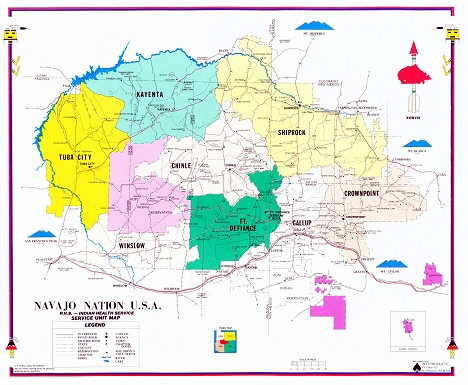 The Navajo Indian Reservation is 27,000 square miles (17,553,809.21 acres) and
its boundary lines extends into three states and lies on eleven counties:
Arizona (Apache, Navajo and Coconino Counties), New Mexico (San Juan, McKinley,
Sandoval, Cibola, Bernalillo, Rio Arriba, Socorro Counties), Utah (San Juan
County). There is 11,593,669.39 acres in Arizona, 4,739,293.37 acres in New
Mexico, 1,220,846.45 acres in Utah, bringing the total to 17,553,809.21 acres.
By percentage, there is 65.35% in Arizona, 27.55% in New Mexico and 7.10% in
Utah. The reservation is larger than the state of West Virginia; West Virginia
is 24,807 square miles.
The Navajo Indian Reservation is 27,000 square miles (17,553,809.21 acres) and
its boundary lines extends into three states and lies on eleven counties:
Arizona (Apache, Navajo and Coconino Counties), New Mexico (San Juan, McKinley,
Sandoval, Cibola, Bernalillo, Rio Arriba, Socorro Counties), Utah (San Juan
County). There is 11,593,669.39 acres in Arizona, 4,739,293.37 acres in New
Mexico, 1,220,846.45 acres in Utah, bringing the total to 17,553,809.21 acres.
By percentage, there is 65.35% in Arizona, 27.55% in New Mexico and 7.10% in
Utah. The reservation is larger than the state of West Virginia; West Virginia
is 24,807 square miles.
Within Navajoland, we have many tribal and national parks and monuments such as the world famous Monument Valley Navajo Tribal Park near the chapter of Kayenta, Lake Powell Navajo Tribal Park, Rainbow Bridge National Monument, Little Colorado River Gorge Navajo Tribal Park, Canyon De Chelly National Monument located near Chinle, Chaco Culture National Historical Park, Beautiful Valley, located between Chinle and Ganado in the Nazlini area, the hidden Bisti Badlands and De-Na-Zin Wilderness, Antelope Canyon Navajo Tribal Park located in the LeChee Chapter, among many others. Our reservation even ends right outside the Grand Canyon National Park! More than 15 national monuments, tribal parks and historic sites are found within Navajoland. It also encompasses a dozen different fishing lakes and ponds, scattered throughout the sprawling reservation. Lake Powell alone - boasts some 186 miles of water front and 2,000 miles of shoreline - more then the entire West Coast! Each of these places have stories and power, they are extremely sacred to the Navajo Nation. Within Navajoland there are 2,000 square miles of mountains, 10,000 square miles of mesas, and 15,000 square miles of deserts, bringing the total to 27,000 square miles. To imagine the vast size in miles of Navajoland... From Albuquerque, New Mexico (east) to Flagstaff, Arizona (west) is 360 miles. From Aneth, Utah (north) to Socorro, New Mexico (south) is 230 miles.
Navajoland is even larger than some countries of the world! Such as: ALBANIA, 11,000 square miles -- BELGIUM, 11,781 square miles -- BOSNIA and HERZEGOVINIA, 19,940 square miles -- COSTA RICA, 19,575 square miles -- CROATIA, 22,050 square miles -- DENMARK, 16,629 square miles -- DOMINICAN REPUBLIC, 18,704 square miles -- ISRAEL, 7,847 square miles -- KUWAIT, 6,532 square miles -- LATVIA, 24,595 square miles -- LEBANON, 4,015 square miles -- LITHUANIA, 25,174 square miles -- MACEDONIA, 9,889 square miles --NETHERLANDS, 15,892 square miles -- RWANDA, 10,169 square miles -- SWITZERLAND, 15,943 square miles -- TAIWAN, 13,971 square miles.
Within Navajoland, 18 lakes can be found. Each of these lakes vary in size. The largest is located in the north western end of the reservation: Lake Powell Navajo Tribal Park. But it is Wheatfields Lake that is the most popular for fishing, it is located at the base of the Chuska Mountains in Arizona, located near the chapter of Wheatfields. Other lakes are named after their nearby community such as Mariano Lake, Casamero Lake, Ganado Lake, Wheatfields Lake, etc. Berland Lake is one of the highest lakes on the reservation, it is located within the Chuska Mountains. Seven miles south of the chapter of Baca-Prewitt is Bluewater Lake State Park. Though surrounded by the reservation, Bluewater Lake State Park is managed by the New Mexico State Parks Administration. For hunting, fishing, trapping and boating permits and fees contact:
Navajo Fish And Wildlife
P.O. Box 1480
Window Rock, Arizona 86515
(928) 871-6451 or 6452
www.navajofishandwildlife.org
These are the lakes that can be found on the reservation: Ganado Lake, Tsaile Lake, Wheatfields Lake, Many Farms Lake, Red Lake (Navajo, New Mexico), Juans Lake (located south of the chapter of Lake Valley, New Mexico), Antelope Lake (9 miles north of the chapter of Pine Springs, Arizona), Asaayi Lake, Whiskey Lake, Berland Lake, Todacheene Lake, Bluewater Lake State Park, Round Rock Lake, Morgan Lake, Chuska Lake (located near the chapter of Tohatchi, New Mexico), Mariano Lake, Casamero Lake, Little White Cove Lake (located south of Wheatfields, Arizona), Lake Powell Navajo Tribal Park.
On the reservation, most of the residents are scattered over rural areas, some for miles. Problems in the area bring people together for meetings and to discuss needs for their land area. People travel many miles over poor roads to listen and to have their voices heard within the community. Needs such as paved roads, repairs or construction of housing, stores, recreational activities, etc. All of these monthly meetings take place at a chapter house. A chapter house is the Navajo equivalent of a town hall. Chapter houses are the center of a Navajo community, as they also use the building for voting of a new tribal president. Chapters sponser recreational events such as rodeo, sports, powwows, social events. Many raise funds for community purposes through these activities. These funds are used for repaired roads, newly developed water wells since water is scarce on the reservation. A senior center can also be found next to a chapter house. There are 110 chapter houses on the 27,000 square mile reservation.
Navajoland is bound by the Four Sacred Mountains. The four sacred mountains represent the Four Directions: East, South, West, North.
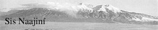 To the East is MT. BLANCA
Navajo Name: Tsisnaajini
Sacred Navajo Name: Yoolgaii Dzil (Strength of White Gem Beads)
Elevation: 14,345 feet above sea level
Location: In the Sangre De Cristo Mountains near Alamos, Colorado. The Holy
People transformed this sacred mountain, attired it with precious gems of white
beads and pure white and black feathers. The white symbolizes purity and
gentleness. It also symbolizes the reproduction of the Navajo people.
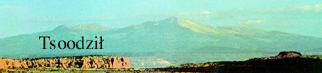 To the South is MT. TAYLOR
Navajo Name: Tsoodzil
Sacred Navajo Name: Dootl' izhii Dzil
Elevation: 11,301 feet above sea level
Location: In the San Juan Mountains, near Grants, New Mexico. The Holy People
transformed this sacred mountain, attired it in gems of turquoise from it's foot
to its crown. It holds a turquoise staff in its hand which hold power and
authority of endless blue universe.
 To the West is the SAN FRANCISCO MOUNTAINS
Navajo Name: Dook' o' osliid
Sacred Navajo Name: Diichili Dzil (Abalone Mountain)
Elevation: 12,633 feet above sea level
Location: In the San Francisco Peaks near Flagstaff, Arizona. This sacred
mountain contains many colors, which represents the twilight horizon closest to
the evening. The Holy People transformed this sacred mountain and attired it in
abalone from its feet to its crown, holding an abalone staff in the right hand,
rules the twilight into the evening. This mountain is also sacred to many
Arizona tribes including the Havasupi Tribe and Hopi Tribe among many others.
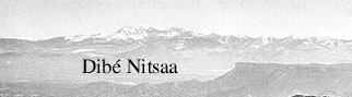 To the North is MT. HESPERUS
Navajo Name: Dibe' nitsaa
Sacred Navajo Name: Baasnzhinni (Onyx Strength)
Elevation: 13,225 feet above sea level
Location: It is located in the La Plata Mountains near Durango, Colorado. The
Holy People attired this mountain in onyx from the feet to the crown. it is also
holding an onyx in the right hand to rule the darkness. It has sovereign power
and authority over the underworld. Most of the sacred ceremonies, chants,
prayers and history of the Dine' originated around this great mountain.
Many visitors think we are a tribe... We are not a tribe, we are a 'nation' because of the huge amount of people within our group. Back in 1864, Christopher 'Kit' Carson and the United States Army under the command of the U.S. President was sent out to round up the people who, at the time, had the population of 10,000 members. Rather than try to defeat the Dineh in battle, Kit Carson first began a scorched-earth offensive. During a six-month period in 1863, his men destroyed fields, orchards, and burned their sacred homes (hogans) and confiscated their livestock. Making the Navajos starve into submission, since they had no livestock and their fields were burned. 10,000 Navajos, who had been at war with the United States for twenty years surrendered. They gave up their land sacred to them and let the invading United States take over. 10,000 people surrendering was the largest in all the Indian wars with the United States. They were taken and walked 300 miles to Fort Sumner to be kept as slaves and to be deported to Indian Territory which is now known as Oklahoma with the other Indian Tribes. While at Fort Sumner from 1864 to 1868, two thousand of the ten thousand Dineh died during their stay there, suffering from outbreaks of disease, shortages of supplies (food, medicine, blankets, lack of space within crowded buildings) infertile soil for planting. For four years, the Navajos almost gave up hope but on June 1, 1868, the federal government reached an agreement with 29 Navajo leaders and signed a treaty granting the Dineh 3.5 million acres of reservation lands in their ancestral homelands. There were twelve Navajo Chiefs and seventeen Navajo Head Men.
The twelve Navajo Chiefs were:
BARBONCITO (Moustached Short Man) Principle Chief of the Navajos
ARMIJO (Former NM Governor's name)
DELGADO (Thin)
MANUELITO (Little Messiah)
LARGO (Tall)
HERRERO (Smith)
CHIQUETO (Small Man)
MUERTO DE HOMBRE (Killer Of Men)
HOMBRE (The Man)
NARBONA (A former Colonel's name)
GANADO MUCHO (Many Cattle)
NARBONO SEGUNDO (Narbona the Second)
The seventeen Navajo Head Men were:
RIQUO(Rio-Rich)
JUAN MARTIN
SERGINTO (Sergeant)
GRANDE (Large)
INOETENITO
MUCHACHOS MUCHO (Many Kids)
CHIQUETO SEGUNDO (Little Man The Second)
CABELLO AMARILLO (Yellow Hair)
FRANCISCO
TORIVIO
DESDENDADO
JUAN
GUERO (Warrior)
GUGADORE (Gambler)
CABASON
BARBON SEGUNDO (Beard The Second)
CABARES COLORADOS (Red Horses)
It took the Navajos only two weeks to prepare for the Long Walk home. When Tsohanoai, the Sun Bearer, appeared in the eastern sky on the morning of June 18, 1868, the first of a column that would stretch out for ten miles across the New Mexico desert left Fort Sumner. Escorted by four companies of cavalry and accompanied by Agent Dodd, his wife and two children (Theodore H. Dodd was appointed agent to the Navajos. He was one of the very first Anglos to become really concerned about the welfare of the Navajos.) The Navajos were dressed in their best clothing they possessed and many of them were smiling for the first time in four years. But progress was slow; they moved but ten or twelve miles each day. On July 5 the Navajos passed through Albuquerque and the next day they forded the Rio Grande. When the returning exiles came into view of familiar horizons and especially the sacred southern mountain Tsoodzil (MT. TAYLOR) they were so overwhelmed with joy that many of the American soldiers guarding them were moved to join their celebration. Paul A. Horgan wrote that one man said: "When we saw the top of the mountain (Mt. Taylor) from Albuquerque we wondered if that was our mountain and we felt like talking to the ground, we loved it so..." (Horgan, Holt, Rhinehart, Winston, 1954: Vol 2, 333.) Many of them fell to their knees and cried. Now, surely, the Gods would return to the Dineh. In this land that had been given to them by Changing Woman prayer-songs to the Holy People would be heard and the Dineh would again be blessed with health and goods. By the first of August the last of the long column had reached Fort Wingate. They had lost just about everything but an indomitable spirit. But they were home... On January 6, 1878 an additional 1.2 million acres was added. Additional lands were added in 1880, 1882, 1884, 1886, 1892, 1900, 1901, 1905, 1907, 1908, 1911, 1912, 1913, 1917, 1930, 1931, 1933, 1934, 1958, and finally in 1986, bringing the reservation to it's present size of 27,000 square miles spread over Arizona, New Mexico and Utah. The reservation is roughly a third of the land area claimed by the Navajos when the Americans entered the southwest. So our tribe was sent back in 1868 to our traditional homeland where we still live today. This was the bleakest event in Navajo history, it was called THE LONG WALK (Five Great Indian Tribes suffered a similar incident, it was the Cherokee Nation, Chickasaw Nation, Choctaw Nation, Creek Nation, and Seminole Nation and they walked from the eastern side of the states to Oklahoma, known as The Trail Of Tears. But unlike the Navajos, these Great Indian Nations were never sent back to their traditional homeland). In 1969, the Navajo Tribal Council officially changed the name from Navajo Tribe to Navajo Nation, it has been used since. From 1868, with the population of 8,000 to January 1, 2000, we have the current population of an estimated 300,000 members!
 The Navajo Nation comprises 298,197 members (2000 Census), and is the largest
native tribe in America. Only the Cherokee claim more members (729,533 members
according to the 2000 Census), but there is a vast difference in the way the two
tribes define their members. The Cherokee require only 1/64th Cherokee ancestry
for legal membership in the tribe. The Navajo require 100% and the person must
have been born on the Navajo Reservation. If the Navajo used the same criteria
as the Cherokee, their membership would be many times larger than the Cherokee.
In turn, the system would be the same if the Cherokee used the same criteria as
the Navajo, their membership would dwindle.
The Navajo Nation comprises 298,197 members (2000 Census), and is the largest
native tribe in America. Only the Cherokee claim more members (729,533 members
according to the 2000 Census), but there is a vast difference in the way the two
tribes define their members. The Cherokee require only 1/64th Cherokee ancestry
for legal membership in the tribe. The Navajo require 100% and the person must
have been born on the Navajo Reservation. If the Navajo used the same criteria
as the Cherokee, their membership would be many times larger than the Cherokee.
In turn, the system would be the same if the Cherokee used the same criteria as
the Navajo, their membership would dwindle.
Another fact, which is rarely used in books and on the internet, is that the Navajo Nation remains as one tribe. Whereas the Cherokee have broken into smaller autonomous tribes. The Cherokee Nation of Oklahoma, itself, has 258,246 members alone. Making them the 2nd largest tribe in the United States. And the Navajo Nation of Arizona, New Mexico, and Utah 298,197 members, making the tribe the largest in the United States.
A look at the 2000 Census and the reason why Navajo Nation is considered the largest Indian Nation in North America and the Cherokee Nation the second largest:
Cherokee Nation(Population):
ALABAMA
Cherokee Tribe of Jackson County(?); Cherokee Tribe of Northeast Alabama(87); Cherokee Tribe of Southeast Alabama(196); Eagle Bear Band of Free Cherokees of Hamilton, AL(?); Echota Band of Cherokee Tribe(3,773); Langley Band of Chickamogee Cherokees of Southeastern AL(?); United Cherokee Tribe(?)
ARKANSAS
Ark Bear Tribe Band of Free Cherokees of Mountain Home, AR(?); Free Cherokees of Helena, AR(?); Free Cherokees of Portland, AR(?); Good Medicine Band of Free Cherokees of Old Joe, AR(?); Lost Cherokee Tribe of AR(?); Old Settler Cherokee Nation of AR(?); Sac River and White River Bands of the Chickamunga Cherokee Nation of AR(?); Western Arkansas Cherokee Tribe of AR(?); Western Cherokee Nation of AR(?)
CONNECTICUT
Moon Band of Free Cherokees of Groton, CT(?); Snake Band of Free Cherokees of Oakville, CT(?)
FLORIDA
Cherokee Tribe of Bascom, FL(?); Cherokee Tribe of Bowling Green, FL(?); Cherokees of Georgia of Hilliard, FL(?); E-Chota Cherokee Tribe of Defuniak Springs, FL(?); E-Chota Cherokee Tribe of Marianna, FL(?); Southeastern Cherokee Confederacy Tribe of Orlando,FL(?); Southeastern Cherokee Confederacy Tribe of Sarasota, FL(?); Southeastern Cherokee Confederacy Tribe of Sebring, FL(?); Tuscola United Band of Cherokee Tribe(?)
GEORGIA
Bear Clan Band of Southeastern Cherokee Confederacy of Adel, GA(?); Cane Break Band of Eastern Cherokee Tribe(?); Cherokee Nation of Texas of Clayton, GA(?); Cherokee Tribe of Scottsdale, GA(?); Deer Clan Band of Southeastern Cherokee Confederacy of Thomasville, GA(?); Eastern Band of Cherokees of Georgia(?); Free Cherokee Tribe of Marietta, GA(?); Good Medicine Band of Cherokee Tribe of Cumming, GA(?); Northern Georgia Chickamaugan Circle Band of Free Cherokees of Flintstone, GA(?); Southeastern Cherokee Confederacy Tribe of Albany, GA(?); Southeastern Cherokee Confederacy Tribe of Lake Park, GA(?); Southeastern Cherokee Confederacy Tribe of Ochlocknee, GA(?); Southeastern Cherokee Confederacy Tribe of Sylvester, GA(?); Southeastern Cherokee Confederacy Tribe of Valdesta, GA(?); Turtle Clan Band of Free Cherokees of Ball Ground, GA(?); Turtle Clan Band of Free Cherokees of Lilburn, GA(?)
KENTUCKY
Black Wolf Band of Southeastern Cherokee Confederacy of Wallins Creek, KY(?); Southeastern Cherokee Confederacy of Kenvir, KY(?)
MARYLAND
Bird Band of Free Cherokees of Lexington, MD(?); Free Cherokee Nation of Mechanicville, MD(?); Wild Potato Band of Free Cherokees of Hollywood, MD(?)
MASSACHUSETTS
Eagle Council Band of Free Cherokees of Reading, MA(?); Wild Potato Band of Free Cherokees of Feeding Hill, MA(?)
MICHIGAN
Rebus Clan Band of Free Cherokees of Holt, MI(?)
MISSISSIPPI
Star Hawk Band of Free Cherokees of Jackson, MS(?)
MISSOURI
Amonsoquath Tribe of Springfield, MO(?); Amonsoquath Tribe of Cherokees of Ozark, MO(?); Dogwood Band of Free Cherokee Tribe of Ashland,MO(?); Chickamunga Cherokee Nation of Brookline, MO(?); Chickamunga Cherokee Nation of Republic, MO(?); Northern Cherokee Tribe(285); Northern Cherokees of Old Louisiana Territory(?); Northern Chickamanga Cherokee Tribe(?); Ozark Mountain Cherokee Tribe of MO(?); Wilderness Tribe of Cherokees of MO(?)
NEW JERSEY
Osprey Band of Free Cherokee Tribe of Mays Landing, NJ(?)
NEW YORK
Deer Council Band of Free Cherokee Tribe(?); Eagle Deer Band of Free Cherokees of Rosedale, Queens NY(?); Free Cherokee Tribe of North Hudson, NY(?); Many Walks Council Band of Free Cherokees of Stony Creek, NY(?); Southeastern Cherokee Confederacy of Mastic, NY(?); Wolf Council Band of Free Cherokees of Scottsville, NY(?)
NORTH CAROLINA
Cherokee Tribe of Hoke County(?); Cherokee Tribe of Robinson County(?); Eastern Band of Cherokee Tribe(8,166); Southeastern Cherokee Confederacy of Cedar Grove, NC(?); Southeastern Cherokee Confederacy of Haw River, NC(?)
OHIO
Hokshichankiya Band of Free Cherokee Tribe of Creola, OH(?)
OKLAHOMA
Cherokee Nation of Oklahoma(258,246); Northern Chickamunga Cherokee Tribe of Weatherford, OK(?); United Keetoowah Band of Cherokee Tribe(528)
OREGON
Northwest Cherokee Wolf Band of Southeastern Cherokee Confederacy(?)
PENNSYLVANIA
Cherokee of Virginia of Allison Park, PA(?); United Cherokee Tribe of Pennsylvania(?)
TENNESSEE
Cherokee Nation of Texas of Memphis, TN(?); Chickamaungan Circle Band of Free Cherokees of Ooltewah, TN(?); Etowah Band of Cherokee Tribe of Cleveland, TN(85); Free Cherokee Tribe of Grand View, TN(?); Kwatani Mission of Chickamunga Cherokee Mark Norman(?); Original Cherokee Nation of Chattanooga, TN(?); Red Clay Band of Southeastern Cherokees(?); Tennessee River Band of Chickamunga Free Cherokees of Knoxville, TN(?)
TEXAS
Cherokee Nation of Texas of Troup, TX(?); Hummingbird Clan of Free Cherokees of Dallas, TX(?); Tejas Band of Sovereign Cherokee Nation of Dallas, TX(?)
VERMONT
Green Mountain Band of Cherokees of Bristol, VT(?); Tribal Council Band of Free Cherokees of Springfield, VT(?)
VIRGINIA
Spider Clan Band of Free Cherokees of Richmond, VA(?); Turtle Band of Cherokees of Evington, VA(?)
Navajo Nation(Population):
ARIZONA, NEW MEXICO, UTAH
Navajo Nation(298,197)
Navajo is a member of a subgroup of the Athabascan branch of the Nadene language family. The Nadene family includes four major branches; the Eyak, the Haida, the Tlingit, and the Athabascan. The Athabascan branch includes a number of more or less closely related languages in interior Alaska (e.g. the Tanaina, Tahltan, Tuchone, Ahtena, etc.), Western Cananda (e.g. the Yellow Knife, Chipewyan, Slave, Dogrib, Carrier, Tsekani, Beaver, Sarsi, etc.), the Northwest Pacific Coast (Upper Umpqua, Chasta Costa, Hupa, Kato, Wailaki, Mattole, etc.) and the Southwestern United States (Navajo, Apache). The latter groups comprise the Apachean subgroup of those related languages which trace their Nadene ancestry through proto-Athabascan.
This is a breakdown of the Athabascan speaking people by area:
THE SOUTHERN ATHABASCAN:
The Southern Athabascan Tribes live in two regions of the southwest; the
Southwestern Area and Oklahoma.
Southwestern Area:
Navajo, Jicarilla Apache, Mescalaro Apache, Tonto Apache, Coyotero Apache, Pinal
Apache, Arivaipa Apache, Chiricahua Apache, Mazatzal Apache, San Carlos Apache,
White Mountain Apache, Cibecue Apache, Sierra Blanca Apache
Oklahoma Area:
Kiowa Apache, Lipan Apache
THE PACIFIC COAST GROUP:
The Pacific Coast Tribes live in three regions; the British Columbia Area, the
Southwestern Oregon Area, and Northwestern California Area.
British Columbia Area:
Nicola, Kwalhioqua, Tlatskanai
Southwestern Oregon Area:
Upper Umpqua, Upper Coquille, Chasta Coasta, Dakube-Tune, Wishtena-Tin, Chetco,
Tutuni, Taltash-Tune
Northwestern California Area: Tolowa, Hoopa, Chilula, Whilkut, Nongatl, Wailaki, Lassik, Mattole, Sinkyone, Kato
THE CANADIAN-ALASKAN GROUP:
The Canadian-Alaskan Tribes live in two regions; the Pacific Drainage Area and
Arctic Drainage Area.
Pacific Drainage Area:
Koyukon, Ingalik, Tanaina, Ahtena, Nabesna, Tanana, Kutchin, Han, Tutchone,
Tahltan, Tsetsaut, Carrier, Chilcotin, Athapascan
Arctic Drainage Area:
Sekani, Kaska, Mountain, Hare, Bear, Dogrib, Slavey, Yellowknife, Beaver, Sarsi,
Chipewyan
Anthropological and linguistic research seems to indicate that the Nadene speaking people arrived in Alaska from Asia about 3000 years ago. By the close of the first millenium after their arrival, the Tlingit and the Athabascan separation had already taken place, and at a period between 1300 and 1000 years ago, segments of the Athabascan speaking peoples migrated to the Pacific coastal area. The migration of other Athabascan speaking people, called the Apacheans, to the Southwest seems to have occured about 1000 to 600 years ago, and linguistic differentiation into the modern forms of Apachean (i.e. Navajo, Jicarilla, Chiricahua, Lipan, etc.) has taken place over the course of the past 400 to 500 years, beginning about the time of the discovery of America.
The relationship of the Nadene to langauges of the Old World remains to be definitively demonstrated and established, but there is a strong probability that a relationship may be proven between Nadene and the Sino-Tibetan languages (the ancestral form of the Chinese and Tibetan language).
[ See: IJAL, Vol. 18, No.4, Oct. 1956, Review by R. Shafer of �Athabascan and Sino-Tibetan�, by Morris Swadesh, and Vol. 18, No. 1 Athabascan and Sino-Tibetan, by R. Shafer.]
The relationship between Navajo and certain Canadian Athabascan languages is apparent in such forms of Navajo loo�, Sarsi tluk�a�, Beaver l�uge, Chipewayan l�uwe, and Carrier l�ooh, all meaning fish. Or Navajo dine�, Sarsi dina�, Beaver dine, Chipewyan dena, and Carrier dineeh, all meaning man, person. As in the instance of the Indo-European languages, there are varying degrees of similarity in the phonology, morphology and structure of Navajo and its linguistic relatives in the North, and even closer similarities with its sister Apachean languages of the American Southwest.
Navajo Phonology: The sound system of Navajo is relatively simple, although it exhibits many features foreign so English and other Indo-European languages - features which frequently pose a problem for English speaking persons learning Navajo or, indirectly, for Navajo speakers who learn English. The basic or Distinctive phonemes (sounds that distinguish meaning) of Navajo are listed and described below:
(A) Vowels and Vowel Clusters: With reference to this category of speech sounds, meaning is distinguished in Navajo by four basic vowel phonemes. But including the additional distinctive features of vowel length (short or long duration), nasalization (or lack of nasalization), and tone (high, low, rising and falling). In writing, these features may be represented by doubling the vowel to indicate length, and by the use of diacritical marks to indicate nasality and tone. In the former case, a �nasal hook� is placed under the vowel to indicate its nasal quality, and in the latter instance an acute accent is used to indicate high tone. Falling and rising tones occur only with long vowels or diphthongs, and acute accent on the first or second vowel symbol suffices to represent graphically all of the essential tonal qualities. Thus, dibe' (high tone), sheep; 'aniigo, (falling tone), he saying; and shi'naai' (rising tone), my elder brother.
Unless they are preceded by another constanant, all Navajo vowels are preceded by a laryngeal closure written \'/.
Tonal pitch serves as he only distinctive feature to differentiate meaning in such words as: ni'li', you are; nili', he is; 'a't'i', he does, he did it; 'at'i', he is rich; 'aze'e', mouth; 'azee', medicine.
Similarity, vowel length distinguishes meaning in bito', his water; bitoo', its juice; bitse' his rock; bitsee', his tail.
Each syllable that composes a word in Navajo has its own inherent tonal pitch and substitution of a low tone for a high tone or vice versa may change the meaning or produce no meaning at all. Thus, 'ayiilaa, he made it; cannot be correctly pronounced as 'ayiilaa*, 'ayiilaa*, etc. Likewise, syllable vowels are inherently short or long in duration, and since vowel distinguishes meaning, each vowel must be uttered with proper length. Under certain circumstances short vowels lengthen and long vowels shorten, following fixed morphophonemix rules, but lengthening of a first 'a' or shortening of the second 'aa' in such a word as 'adzaa (to make 'aadzaa* 'aadza* etc.) would not be meaningful.
The Morphology and Structure Of Navajo: Although Navajo and English are markedly divergent phonologically, the difference is extreme in terms of their morphological and structural features. Each divergence between unrelated speech systems is , of course, to be expected, bgut it is mentioned here because of the implications such differences habe for the Navajo learning English and for the teacher who presents English to Navajos as a foreign language.
[STILL FINISHING ON ATHABASCAN LANGUAGE... CHECK BACK LATER FOR UPDATE]
Like their linguistic cousins, the Navajo, the Apache Nation is one of the ten largest tribal nations in America. Ranking the 7th largest tribe, the Apache are well known as excellent horse riders and very war like against their enemies. Although the 1990 Census placed them the 7th largest, but by tribal breakdown or individual tribes, they are divided into 9 smaller bands and scattered into three states. Arizona hold the most Apache bands. They are: Came Verde Apache Tribe (also called Yavapai-Apache Tribe), Fort McDowell Apache Tribe (also called Mohave-Apache Tribe), San Carlos Apache Tribe, Tonto Apache Tribe, White Mountain Apache Tribe. New Mexico is homeland to two Apache bands. They are: Jicarilla Apache Nation and Mescalaro Apache Tribe. Oklahoma is the last and chosen home for the last two Apache bands. They are: Fort Sill Apache Tribe (also called Chiricahua Apache Tribe or Chief Geronimo's Band of Apache Tribe), Oklahoma Apache Tribe (also called Kiowa Apache Tribe). The Arizona Apache Tribes men have similiar clothing to the Navajo men, wearing a headband and similar clothing, but the women, unlike Navajo women wear the buckskin dresses and the Jicarilla, Mescalaro, Lipan and Kiowa Apache Tribes have all adopted the Plains way of life; living in teepees and wearing the feathered headdresses. Many Navajos continue to wear traditional clothing daily. Others wear their velvet, turquoise and silver only during ceremonial or social gatherings. The Navajo women's traditional style of dress consists usually of foot or knee-high moccasins, a pleated velvet or cotton skirt, a matching long sleeve blouse, concho and/or sash belt, jewelry and a shawl. Men also wear jewelry, moccasins and preferably a velveteen shirt. Although many Navajo people wear contemporary clothing, they continue to carry on their cultural practices by wearing traditional outfits when the occasion requires it. It is believed that before an individual can receive help from the Great Spirit, one must first wear appropriate clothing in order to be recognized.
Unlike those John Wayne movies, we the Navajos don't live in teepees nor do we wear the feathered headdresses or shout out loud when riding horses (Shouting out loud was considered rude and disrespectful in our tribe; although it was considered bravery to the Sioux Nation). The teepees and feathered headdresses belong to the Plains Indians of North and South Dakota, Kansas, Oklahoma, and Colorado, Idaho and some Washington tribes (Sioux, Ponca, Kiowa, Arapaho, Ute, Nez Perce, and some Apache tribes and various others.) We live in hogans, it is our traditional home. Other tribes have other dwellings, the Seminoles of Florida live in chickees, the Iroquois of New York live in long houses, the Paiutes of Nevada live in wickiups, the California tribes live in brush houses or huts and so on...
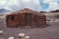 The hogan is a circular shape house made of mud, clay and logs. The door always
faces the east because that's where the sun rises. It is a circular shape
because the circle is a very sacred symbol to us. The family who live in the
hogan are all treated the same. The Navajos have a different view of the whole
marriage system, the husband is NOT the head of the household, all is equal;
husband, wife and children. The Navajos do not refer to their mode of living as
a way of life; it IS the way of life... The Beautiful Rainbow of the Navajo. At
the center of the Navajo world is their shelter, the hogan. The ancient hogan,
known as the "forked stick hogan" was a conical hut constructed of three forked
poles covered with logs, brush and mud. Called the 'male' hogan by the Navajos,
examples of this dwelling can still occasionally be found in the western part of
the reservation. More common today is the 'female' hogan, a circular or
eight-sided dwelling constructed of logs or stone, with the doorway always
facing east. Traditionally the hogan lacked windows and was ventilated by the
smoke hole in the roof. Nowadays, not only do most hogans have windows but they
may also have stoves, chimneys, beds, refrigerator, television, and microwave.
The Navajo hogan is more than just a place to eat and sleep and the concept of
it as a 'home' bears little resemblance to a white person's attitude toward his
dwelling place. The hogan is a gift of the gods and as such it occupies a place
in the sacred world. The first hogans were built by the Holy People of
turquoise, white shell, jet and abalone shell. The round hogan is symbolic of
the sun and its door faces east so that the first thing a Navajo family sees in
the morning is the rising sun... Father Sun, one of the most revered of the
Navajo deities. The construction of a new hogan is almost always a community
affair. Once completed, the new hogan is consecrated with a Blessing Way Rite,
whereby the Holy People are asked to "let this place be happy."
The hogan is a circular shape house made of mud, clay and logs. The door always
faces the east because that's where the sun rises. It is a circular shape
because the circle is a very sacred symbol to us. The family who live in the
hogan are all treated the same. The Navajos have a different view of the whole
marriage system, the husband is NOT the head of the household, all is equal;
husband, wife and children. The Navajos do not refer to their mode of living as
a way of life; it IS the way of life... The Beautiful Rainbow of the Navajo. At
the center of the Navajo world is their shelter, the hogan. The ancient hogan,
known as the "forked stick hogan" was a conical hut constructed of three forked
poles covered with logs, brush and mud. Called the 'male' hogan by the Navajos,
examples of this dwelling can still occasionally be found in the western part of
the reservation. More common today is the 'female' hogan, a circular or
eight-sided dwelling constructed of logs or stone, with the doorway always
facing east. Traditionally the hogan lacked windows and was ventilated by the
smoke hole in the roof. Nowadays, not only do most hogans have windows but they
may also have stoves, chimneys, beds, refrigerator, television, and microwave.
The Navajo hogan is more than just a place to eat and sleep and the concept of
it as a 'home' bears little resemblance to a white person's attitude toward his
dwelling place. The hogan is a gift of the gods and as such it occupies a place
in the sacred world. The first hogans were built by the Holy People of
turquoise, white shell, jet and abalone shell. The round hogan is symbolic of
the sun and its door faces east so that the first thing a Navajo family sees in
the morning is the rising sun... Father Sun, one of the most revered of the
Navajo deities. The construction of a new hogan is almost always a community
affair. Once completed, the new hogan is consecrated with a Blessing Way Rite,
whereby the Holy People are asked to "let this place be happy."
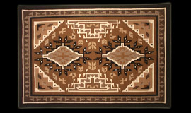
Our arts and crafts are known nationally as well as internationally, especially the rug weaving made by the women. The men make turquiose and silver jewelry and sandpainting. The beginnings of the art of sandpainting are lost in history. Until recently it has been used only as an impermenent but important part of the Navajo religious life. The sandpainting are drawn with painstaking care by the singer. Often referred to as the medicine man by the outside world, the "hataali" is a highly trained practitioner of the Navajo religious knowledge and practice. Sandpainting are part of the rituals which call the Holy People, creating an alter where sacramental activities take place. At the appropriate time in the singing the sandpainting is made on the floor of the hogan. The images in the painting, along with the singing, attract the Holy People to the ceremony. The "patient" (the one for whom the ceremony is being sung) sits on the sandpainting facing east. The singer takes sand from figures in the sandpainting and applies them to the patient in a prescribed manner. In this way the power of the Holy People is transferred to the patient for healing or blessing. When the ceremony is complete the sandpainting is carefully "erased." The sand is gathered into a blanket and safely deposited north of the hogan, to protect others from contamination. Navajos are unsurpassed in their ability to create exquisite and multifaceted art.
 Nowhere is this more true than in the beauty of their silversmithing.
Introduced by the Spaniards and Mexicans around the middle of the 19th Century,
silversmithing Navajos obtained metal by melting down American silver dollars
and Mexican pesos. Navajo lore teaches that when the Dineh came from the
underworld, First Man brought turquoise with him and directed shovels to be made
of turquoise to dig channels and drain much of the water that was present. It's
believed that the Navajos began working with turquoise after returning from Fort
Sumner, New Mexico in 1868. Aside from its ornamental value, turquoise is
especially important to the Navajo people because of its ceremonial
significance. Today, turquoise is used primarily for ornamentation, but Navajos
remember to wear it ceremonially as exemplified in the many rituals still held
today. While the art of basketmaking may seem minor, a basket has great symbolic
significance because it represents the well-being of an individual, particulary
the mind.
Nowhere is this more true than in the beauty of their silversmithing.
Introduced by the Spaniards and Mexicans around the middle of the 19th Century,
silversmithing Navajos obtained metal by melting down American silver dollars
and Mexican pesos. Navajo lore teaches that when the Dineh came from the
underworld, First Man brought turquoise with him and directed shovels to be made
of turquoise to dig channels and drain much of the water that was present. It's
believed that the Navajos began working with turquoise after returning from Fort
Sumner, New Mexico in 1868. Aside from its ornamental value, turquoise is
especially important to the Navajo people because of its ceremonial
significance. Today, turquoise is used primarily for ornamentation, but Navajos
remember to wear it ceremonially as exemplified in the many rituals still held
today. While the art of basketmaking may seem minor, a basket has great symbolic
significance because it represents the well-being of an individual, particulary
the mind.
Navajo legend teaches that the Holy People - First Man and First Women - made baskets when they lived in the underworld for ceremonial purposes. Each part of a Navajo basket has a special significance. The core of the basket represents the emergence of the Holy People into the present world - the Fifth World. The area surrounding the core represents the earth.
Traditional Navajo baskets have a first layer of black triangular design, representing the Four Sacred Mountains. That area immediately adjacent to the black represents the sky; the red design represents the clouds and darkness. The black triangular designs on the outside of the basket represents the Holy People, including Yellow Corn and Dawn. Finally, the outer edge of the basket represents the association with others. Apart from their ceremonial usage, Navajos also use baskets for ornamentation. However, many documentaries on our arts and crafts always show women do the weaving and the men do the jewelry making. Our arts and crafts are NOT based on gender. Many Navajo women also do the jewelry making and a large majority of the men weave rugs and blankets. The weaver first sheers his or her sheep, the wool is spun into yarn. The weaver then goes out to look for certain plants or seeds they use to dye the wool into the desired color.
 Listed are the plants or seeds that a weaver uses for colors: Wood Lichin,
Gambel Oak Bark, Mariposally, Scarlet Bugler, Sage Brush, Juniper Mistletoe,
Brigham Tea, Blue Flower Lupine, Wild Walnut Shells, Navajo Tea, Mt. Mahogany
Root, Purple Larkspur, Wild Buck Wheat, Brown Onion Skin, Wild Black Berries,
Butter and Egg Plant, Apple Peeling, Yellowsweet Clover, Wild Walnut Leaves,
Canaigre Dock Blossom, Blue Penstemon, Wild Sunflower, One Flowered Actenia,
Sumac Leaves Pinon, Pitch and Ocher, Purple Bee Plant, Red Gilia, Ground Lichin,
Red Onion Skin, Rosehips, Cliffrose, Orange Peeling, Cochineal, Indian
Paintbrush, Alder Bark, Globemallow, Sumac Berries, Wild Holly Berries, Red
Juniper Root and Hematite, Canaigre Dock Root, Prickly Pear, Cactus Fruit,
Rubber Plant, Walnut, Four o'Clock, Rhubard, Cranberries, Gooseberry.
Listed are the plants or seeds that a weaver uses for colors: Wood Lichin,
Gambel Oak Bark, Mariposally, Scarlet Bugler, Sage Brush, Juniper Mistletoe,
Brigham Tea, Blue Flower Lupine, Wild Walnut Shells, Navajo Tea, Mt. Mahogany
Root, Purple Larkspur, Wild Buck Wheat, Brown Onion Skin, Wild Black Berries,
Butter and Egg Plant, Apple Peeling, Yellowsweet Clover, Wild Walnut Leaves,
Canaigre Dock Blossom, Blue Penstemon, Wild Sunflower, One Flowered Actenia,
Sumac Leaves Pinon, Pitch and Ocher, Purple Bee Plant, Red Gilia, Ground Lichin,
Red Onion Skin, Rosehips, Cliffrose, Orange Peeling, Cochineal, Indian
Paintbrush, Alder Bark, Globemallow, Sumac Berries, Wild Holly Berries, Red
Juniper Root and Hematite, Canaigre Dock Root, Prickly Pear, Cactus Fruit,
Rubber Plant, Walnut, Four o'Clock, Rhubard, Cranberries, Gooseberry.
Navajos proudly sell their jewelry, baskets, sandpaintings, beaded keychains, etc. all over the reservation. From Navajo gift shops and jewelry stores or directly from the maker themselves as they usually sell near tribal and national monuments and parks such as Canyon De Chelly National Monument or Monument Valley Navajo Tribal Park. In my opinion, it would be cheaper to buy direct from the artist themselves, the ones who sit on folding chairs and lay their jewelry on tables for tourists to buy, rather than gift shops and jewelry stores; because also if you have a question about the product, you could ask the artist directly face to face and you would receive an answer from the artist themselves.
The blankets come in many designs. Only a real expert will tell you where the rug or blanket was woven at just by the look on the design! All over the reservation on certain town or villages come certain designs. The more famous known is the Two Grey Hills Rug, they are woven and made at... Of course, Two Grey Hills, New Mexico. And the others at Pine Springs, Burntwater, Klagetoh, Nazlini, Manyfarms, Coyote Canyon, Tees Nos Pos, Lukachukai, Red Mesa, Crystal, Chinle, Wide Ruins, Ganado, Coal Mine, Keams Canyon, West Reservation Areas and Shiprock. All of these towns are scattered throughout the 27,000 square mile reservation and each has it's own rug and blanket designs!
Like every way of life, there has to be a bad side to things. One of the most sensative subjects on Navajoland is the long standing fued with the neighboring Hopi Pueblo Indian Tribe. Or the more well known...
 Navajo-Hopi Land Dispute
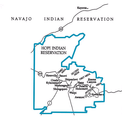
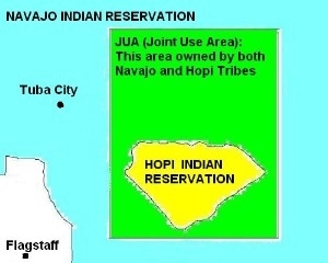
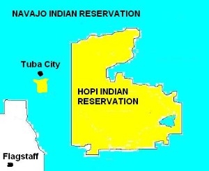
The Navajos have been disputing with the Hopis over reservation boundaries and sacred places. First of all, the Hopi Tribe are a completely different tribe than the Navajos. They are Pueblos, we're not. We live in hogans, they live in adobe houses. We speak Athabascan, the Hopi Tribe speaks a Uto-Aztecan language. The Hopi people live on or near the southern escarpment of Black Mesa in northeastern Arizona. As the westernmost Puebloan people, the Hopis live on thirteen villages on three finger-like projections south from Black Mesa and to the west along Moencopi Wash. There are three villages on First Mesa: Walpi, Sichomovi, and the Tewa-speaking village of Hano; the modern community of Polacca has spread at the base of the narrow mesa. Second Mesa includes the villages of Shipaulovi and Mishongnovi, which occupy small, isolated promontories, and the large village of Shungopavi. Prior to the twentieth century, there was only one Third Mesa Village, Oraibi. But a factional split in 1906 and further dissension over the next several years led to the development of Hotevilla, Bacabi, and New Oraibi (Now called Kykotsmovi). Forty miles to the west, a summer farming village expanded and divided to form Lower and Upper Moencopi. The Hopis, like all Indians of the great southwest, are the product of ancestry and environment. The Hopis built two-storied pueblos of mud-mortered stone. The original buildings had no doors or windows and were entered through a hole in the roof. The Hopi are extraordinary potters and weavers, talented craftspeople who live in harmony with the land, using its resources to produce crops, intricate basketry and beautiful pottery. Their religion stems from ancient times. The kachinas, or spirits, dominate their religious rituals. Hopi children learn of the kachina early in life. Among their most treasured possessions are wooden kachina dolls. Replicas of the kachinas are carved from cottonwood root and are VERY popular with collectors. They are the only Pueblo tribe in Arizona; the 19 other Pueblo Tribes live in New Mexico (Acoma, Cochiti, Isleta, Jemez, Laguna, Nambe, Picuris, Pojoaque, San Felipe, San Ildefonso, San Juan, Sandia, Santa Ana, Santa Clara, Santo Domingo, Taos, Tesuque, Zia and Zuni Tribes.) The Hopi are the largest of the Pueblos, they have 11,000 members. The Hopi Reservation is 1,561,213 acres and is completely surrounded by the Navajo Reservation.
 By executive order of December 16, 1882, the Hopi was originally granted
2,472,254 acres in northeastern Arizona. The Hopi Reservation was centered
within a larger area (considered by the Hopi Tribe also to be their ancestral
land) which was designated the Navajo Reservation. As populations increased, the
Navajo expanded their settlements well beyond their own borders, encroaching
onto the Hopi Reservation. In 1934 Congress expanded the Navajo Reservation so
that it completely surrounded the Hopi Reservation. This was the effect of "the
disputed area of 1934." This is the location of the traditional Hopi town of
Moencopi. The 8-million acre area was also later settled by Navajo people, whose
town of Tuba City was formed. This area is outside the rectangular boundary of
the 1882 Hopi Reservation, and by act of Congress the entire area later became
one of the larger expansions of the Navajo Reservation. Also included in this
Navajo land expansion was all the land of the very small San Juan Band Of
Southern Paiute Tribe, who have been left without a land base ever since. In
obtaining this land for the Navajo Nation, lawyers had argued that "Indians"
have lived there since time immemorial. Because of the disputes about the
western 1934 area, when the 1974 Navajo-Hopi partioning law -- which covers the
Hopi Reservation, the former Joint Use rectangular area -- was passed, Interior
Secretary Bennett placed a "freeze" on housing construction, development, and
even repairs of structures there known as the Bennett Freeze. On April 30, 1992,
there was a victory for the Navajo Nation over the Hopi Tribe about the lawsuit
the Hopis had filed over the 1934 disputed western reservation land area.
Because of the victory the (lower) court ordered an unfreeze on the 27 year
Bennett Freeze in the disputed area. Considerable Navajo building and repairs
took place over the next few years. Meanwhile, the Hopi Tribe prepared for an
appeal. Another land reduction for the Hopis occured in 1936, this one within
the rectangular boundary of their reservation established in 1882. As part of a
stock-reduction plan to reduce overgrazing from sheep and goats (Mostly Navajo),
the BIA (Bureau of Indian Affairs) divided the Hopi homeland rectangle into 18
land-management grazing districts, of which ONLY ONE 'District Six' (about 1/5
of the original divided area) was allocated exclusively to Hopis. The remaining
17 districts within the rectangle were given to the Navajo Nation. The Hopi
complained, the government failed to act, and the Navajo continued to overrun
Hopi lands until they had taken over 1,800,000 acres of the original Hopi
designation. The Hopi were left with only about 600,000 acres. In 1958, a
special act of Congress permitted the two tribes to sue each other in their
dispute over the land question. The lawsuit, Healing v. Jones was decided in
1962, a federal court ruling established a certain area (the 17 land-management
grazing districts) surrounding the Hopi Land as a Joint Use Area (JUA)
accessible to both tribes, meaning the JUA lands were owned by both Navajo and
Hopi. When oil and coal were discovered on the JUA land, the tribes became more
interested in clearly defining ownership. Congress finally passed the
Navajo-Hopi Settlement Act in 1974, which divided the land between the Navajo
and Hopi and returned 900,000 acres to the Hopi, authorizing the division of the
JUA between the two tribes and requiring people living on the other tribe's land
to relocate (this applied to nearly 11,000 Navajos living on Hopi side and only
109 Hopis living on the Navajo side. The JUA [Joint Use Area] was no longer in
affect). The dispute over resettlement and the remaining 900,000 original acres
continues. The removal of 11,000 people was the largest removal of U.S. citizens
in the history of the United States. The Navajos were forced to leave and sent
far away as Albuquerque, and Los Angelas and Denver and Phoenix and other places
not known to them.
By executive order of December 16, 1882, the Hopi was originally granted
2,472,254 acres in northeastern Arizona. The Hopi Reservation was centered
within a larger area (considered by the Hopi Tribe also to be their ancestral
land) which was designated the Navajo Reservation. As populations increased, the
Navajo expanded their settlements well beyond their own borders, encroaching
onto the Hopi Reservation. In 1934 Congress expanded the Navajo Reservation so
that it completely surrounded the Hopi Reservation. This was the effect of "the
disputed area of 1934." This is the location of the traditional Hopi town of
Moencopi. The 8-million acre area was also later settled by Navajo people, whose
town of Tuba City was formed. This area is outside the rectangular boundary of
the 1882 Hopi Reservation, and by act of Congress the entire area later became
one of the larger expansions of the Navajo Reservation. Also included in this
Navajo land expansion was all the land of the very small San Juan Band Of
Southern Paiute Tribe, who have been left without a land base ever since. In
obtaining this land for the Navajo Nation, lawyers had argued that "Indians"
have lived there since time immemorial. Because of the disputes about the
western 1934 area, when the 1974 Navajo-Hopi partioning law -- which covers the
Hopi Reservation, the former Joint Use rectangular area -- was passed, Interior
Secretary Bennett placed a "freeze" on housing construction, development, and
even repairs of structures there known as the Bennett Freeze. On April 30, 1992,
there was a victory for the Navajo Nation over the Hopi Tribe about the lawsuit
the Hopis had filed over the 1934 disputed western reservation land area.
Because of the victory the (lower) court ordered an unfreeze on the 27 year
Bennett Freeze in the disputed area. Considerable Navajo building and repairs
took place over the next few years. Meanwhile, the Hopi Tribe prepared for an
appeal. Another land reduction for the Hopis occured in 1936, this one within
the rectangular boundary of their reservation established in 1882. As part of a
stock-reduction plan to reduce overgrazing from sheep and goats (Mostly Navajo),
the BIA (Bureau of Indian Affairs) divided the Hopi homeland rectangle into 18
land-management grazing districts, of which ONLY ONE 'District Six' (about 1/5
of the original divided area) was allocated exclusively to Hopis. The remaining
17 districts within the rectangle were given to the Navajo Nation. The Hopi
complained, the government failed to act, and the Navajo continued to overrun
Hopi lands until they had taken over 1,800,000 acres of the original Hopi
designation. The Hopi were left with only about 600,000 acres. In 1958, a
special act of Congress permitted the two tribes to sue each other in their
dispute over the land question. The lawsuit, Healing v. Jones was decided in
1962, a federal court ruling established a certain area (the 17 land-management
grazing districts) surrounding the Hopi Land as a Joint Use Area (JUA)
accessible to both tribes, meaning the JUA lands were owned by both Navajo and
Hopi. When oil and coal were discovered on the JUA land, the tribes became more
interested in clearly defining ownership. Congress finally passed the
Navajo-Hopi Settlement Act in 1974, which divided the land between the Navajo
and Hopi and returned 900,000 acres to the Hopi, authorizing the division of the
JUA between the two tribes and requiring people living on the other tribe's land
to relocate (this applied to nearly 11,000 Navajos living on Hopi side and only
109 Hopis living on the Navajo side. The JUA [Joint Use Area] was no longer in
affect). The dispute over resettlement and the remaining 900,000 original acres
continues. The removal of 11,000 people was the largest removal of U.S. citizens
in the history of the United States. The Navajos were forced to leave and sent
far away as Albuquerque, and Los Angelas and Denver and Phoenix and other places
not known to them.
 In ammendments to the 1974 partitioning act, Navajos received
an additional 426,691 acres of replacement land -- 75,000 of this being a coal
mine in New Mexico -- that was supposed to provide homes for relocated Navajos,
moved off Hopi partitioned land. The other 351,691 acres was established along
the Arizona part of the Arizona-New Mexico border and south of the established
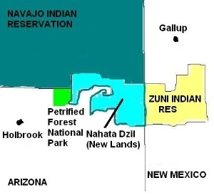
Navajo Nation. The New Lands lies on the communities of Sanders, Chambers, and
Navajo, Arizona. Almost touching the Petrified Forest or 60 miles east of
Holbrook, Arizona. This area is called by the Navajos as the "New Lands", or
Nahata Dziil. Relocated Navajos were moved to the 'new lands' and the once
desolated area grew into a small Navajo community. It was established in 1986,
the last of reservation lands added to the Navajo Nation and the last chapter to
be certified. Nahata Dziil was certified on April 4, 1991. A federal Navajo and
Hopi Relocation Commision was formed, whose funding has -- over some 20 years --
added up to more than $300,000,000 to assist with relocations of tribal people
who were living on lands assigned to the other tribe. This has gone almost
entirely to the Navajo Nation, with some to relocate families, who had been
living off Hopi land, because obviously 11,000 Navajos were relocated and only
109 Hopis were relocated. A Navajo tribal agency, the Navajo-Hopi Land
Commission, was established to manage the process. Approximately 11,000 Navajos
have been relocated. Most published reports say the numbers to be relocated by
the land partitioning were 10,000 Navajos -- who had been living within the
boundaries of the 1882 Hopi Reservation that were partitioned back to Hopi
ownership -- and 109 Hopis, who had been living on that part of their 1882
reservation that was partitioned to Navajo ownership.
In ammendments to the 1974 partitioning act, Navajos received
an additional 426,691 acres of replacement land -- 75,000 of this being a coal
mine in New Mexico -- that was supposed to provide homes for relocated Navajos,
moved off Hopi partitioned land. The other 351,691 acres was established along
the Arizona part of the Arizona-New Mexico border and south of the established
Navajo Nation. The New Lands lies on the communities of Sanders, Chambers, and
Navajo, Arizona. Almost touching the Petrified Forest or 60 miles east of
Holbrook, Arizona. This area is called by the Navajos as the "New Lands", or
Nahata Dziil. Relocated Navajos were moved to the 'new lands' and the once
desolated area grew into a small Navajo community. It was established in 1986,
the last of reservation lands added to the Navajo Nation and the last chapter to
be certified. Nahata Dziil was certified on April 4, 1991. A federal Navajo and
Hopi Relocation Commision was formed, whose funding has -- over some 20 years --
added up to more than $300,000,000 to assist with relocations of tribal people
who were living on lands assigned to the other tribe. This has gone almost
entirely to the Navajo Nation, with some to relocate families, who had been
living off Hopi land, because obviously 11,000 Navajos were relocated and only
109 Hopis were relocated. A Navajo tribal agency, the Navajo-Hopi Land
Commission, was established to manage the process. Approximately 11,000 Navajos
have been relocated. Most published reports say the numbers to be relocated by
the land partitioning were 10,000 Navajos -- who had been living within the
boundaries of the 1882 Hopi Reservation that were partitioned back to Hopi
ownership -- and 109 Hopis, who had been living on that part of their 1882
reservation that was partitioned to Navajo ownership.
 About 250 Navajo families
in the Big Mountain area on Hopi land have refused. In October, 1996, the two
tribes agreed on what is again supposed to be final settlement that includes a
75 year leases to be offered by the Hopi Tribe to those Navajo families who do
not want to move off Hopi land. But it is Hopi land, not the Navajo Nation, will
have jurisdiction there. This is not acceptable to the Navajo residents group,
but Navajo jurisdiction over any of their remaining land is not acceptable to
the Hopi Tribe. We're also trying to get a sacred place to be a part of our
reservation because it holds an important significance to the Navajo people. It
is called Big Mountain. At this time, Big Mountain is on the Hopi side of the
reservation. Big Mountain is also sacred to the Hopi Tribe, but because they're
a different tribe, they have a different story and belief with Big Mountain.
When Congress divided the land and relocated the Navajos to places not known to
them, they call the relocation of their people as THE SECOND LONG WALK. So
that's what it's all about... cultural differences, a history of United States
interferance, expanding reservation populations and Peabody Coal Mine (which was
discovered on Joint Use Area) are all responsible for the 118 year old land
dispute which still continues on today, THE 118 YEAR OLD LAND DISPUTE IS ONE OF
THE LONGEST COURT BATTLES IN THE HISTORY OF THE UNITED STATES!
About 250 Navajo families
in the Big Mountain area on Hopi land have refused. In October, 1996, the two
tribes agreed on what is again supposed to be final settlement that includes a
75 year leases to be offered by the Hopi Tribe to those Navajo families who do
not want to move off Hopi land. But it is Hopi land, not the Navajo Nation, will
have jurisdiction there. This is not acceptable to the Navajo residents group,
but Navajo jurisdiction over any of their remaining land is not acceptable to
the Hopi Tribe. We're also trying to get a sacred place to be a part of our
reservation because it holds an important significance to the Navajo people. It
is called Big Mountain. At this time, Big Mountain is on the Hopi side of the
reservation. Big Mountain is also sacred to the Hopi Tribe, but because they're
a different tribe, they have a different story and belief with Big Mountain.
When Congress divided the land and relocated the Navajos to places not known to
them, they call the relocation of their people as THE SECOND LONG WALK. So
that's what it's all about... cultural differences, a history of United States
interferance, expanding reservation populations and Peabody Coal Mine (which was
discovered on Joint Use Area) are all responsible for the 118 year old land
dispute which still continues on today, THE 118 YEAR OLD LAND DISPUTE IS ONE OF
THE LONGEST COURT BATTLES IN THE HISTORY OF THE UNITED STATES!
Peabody Coal Mine
Peabody's Group's Arizona coal mining operations injected more than $100 million
in direct economics benefits to reservation communities in the year ended March
31, company officials reported. The results, which included royalties, taxes,
wages, benefits and charitable contributions generated by the Black Mesa and
Kayenta Mines, raised the company's 30-year economic benefit to more than $1.8
billion. The Black Mesa and Kayenta mines are operated through lease agreements
with the Navajo Nation and Hopi Tribe, producing about 13 million tons of
low-sulfur coal annually for the Mohave Generating station near Laughlin,
Nevada, and the Navajo Generating station near Page, Arizona. Mining operations
provide about 700 jobs on reservation lands where unemployment hovers at 56
percent. more than 90 percent of the Black Mesa work force is Native American.
During the period, wages and benefits for the two mines exceeded $5.12 million,
with the average coal miner's wage topping $45,000. These wages are
approximately eight times higher than the 1997 per capita income for the Navajo
Nation and about two times higher than Arizona's per capita income. "The Black
Mesa and Kayenta Mines provide enormous economic benefits in the region, weekly
injecting nearly $2 million in tribal economies," said John Wasik, Peabody's
group executive for Southwest Operations. "Mining on Black Mesa serves as a
prime source of tribal royalty and tax revenue, while providing much needed jobs
that enable personal and professional growth."
Peabody's mining operations generated approximately $49 million in royalties, taxes and other payments in the past year, providing nearly 40 percent of the Navajo Nation's general budget and about 80 percent of the Hopi Tribe's budget. Adjustments to the tribal coal lease agreements renegotiated with the Navajo and Hopi in 1998 will increase tribal revenue by $45 million over the next decade. "Peabody is among the nation's largest private employers of American Indians and has a long history of supporting tribal communities at a variety of levels," said Wasik. "We are proud to provide a solid foundation for economic growth on reservation lands". Local communities and schools also are supported through charitable giving. Each year, the company's taxes generate about $1.5 million in revenue for Kayenta Unified School District. Peabody has an active co-op student intern program and provides more than $320,000 in annual scholarships to Navajo and Hopi students across the two reservations (Navajo and Hopi Reservations). Peabody is the WORLD'S LARGEST COAL COMPANY with operations also in Australia. It's coal products fuel more than 9 percent of all U.S. electricity generation and 2.5 percent of worldwide electricity generation.
Navajo Indian Irrigation Project
The Navajo Indian Irrigation Project (NIIP), part of the 1868 treaty settlement,
was established to assist the Navajo Nation in creating an agricultural economy.
NIIP is located in the northeast corner of the Navajo Nation, south of
Farmington, New Mexico. Water is diverted through NIIP from the Navajo Dam,
which impounds the waters of the San Juan River.
Navajo Agricultural Products Industries
In 1970, the Navajo Tribal Council approved the Navajo Agricultural Products
Industries (NAPI) plan of operation to develop, operate, and manage the
agribusiness functions of NIIP. Close to two-thirds of NAPI's planned 110,630
acres are under cultivation. NAPI has established storage and processing
facilities for alfalfa, beans, corn, onions, barley, wheat, and potatoes. NAPI
controls business ventures that grow pumpkins, melons, orchard crops, sod, grass
seed, and other specialty crops. In addition, NAPI has developed a testing
laboratory, industrial park, and a more than 35,000-head feedlot. NAPI directly
employs 300 full time and 1,500 seasonal personnel, 99 percent of whom are
members of the Navajo Nation. NAPI ships products all over the country and the
world. Included among NAPI's major nationally recognized customers are
Frito-Lay, Campbell's Soup, Eagle Snack Foods, and Clover Club. The "Navajo
Pride" label appears on several NAPI-grown products, including potatoes, onions,
and alfalfa pellets. The Navajo Nation has approximately 6,000 active
livestock-grazing permits, involving almost 400,000 head of cattle, horses,
sheep, and goats on over 13.5 million acres. NAPI itself runs over 17,000 head
of cattle.
 Dot on the map on the right shows location of the San Juan Paiute Tribe. On
March 18, 2000 at Hidden Springs, Arizona, north of Tuba City, the Navajo Nation
and the San Juan Paiute Tribe signed the first treaty that two Indian Tribes
have signed with each other in 160 years. In 1989, the San Juan Band of Southern
Paiute was federally recognized by the United States. Although recognized, the
small 310 member tribe didn't have a land base or a reservation they could call
home. Without a reservation, an Indian Tribe can't get help from the government.
Southern Paiute is a linguistic and cultural group in the northern Southwest and
the southeastern Great Basin area. Both the language and the ethnic group are
frequently referred to simply as "Paiute," not to be confused with the Northern
Paiutes, a related but separate group who speak a mutually unintelligible
language. In the mid-ninteenth century, when sustained contact with
Euroamericans was just beginning, Southern Paiute territory covered a large
contiguous area in Arizona, Utah, Nevada, and California. However, the ten
modern Southern Paiute groups retained only a tiny portion of this land and
tribal members now live in widely separated communites both on and off the
reservations. Five Utah based Paiute bands or groups: Shivwits Paiute, Indian
Peaks Paiute, Cedar City Paiute, Koosharem Paiute, and Kanosh Paiute, recently
united to form a larger tribal entity, the Paiute Tribe of Utah. The San Juan
Paiute Tribe's communities are located in both Arizona and Utah, within the
presently constituted borders of the Navajo Reservation. The Kaibab Paiute Tribe
has a reservation on the "Arizona Strip" north of the Grand Canyon. The three
Southern Nevada tribes are Moapa Paiute, Las Vegas Paiute, and Pahrump Paiute.
Pahrump is the only modern Southern Paiute political group that is not
recognized by the federal government. It has, however, initiated a process of
becoming federally recognized. By the beginning of the 20th century, Paiute life
has changed. They had lost control over most of their traditional homeland to
incoming groups. Paiutes lost land to miners and ranchers in California and
Nevada, Mormon farmers in Utah and Arizona and the larger Navajo Nation in what
was to become the Western Navajo Reservation. Despite a continuing San Juan
Paiute presence, in 1933 their traditional homeland was made part of the Navajo
Reservation based on the lawyers argument that "Indians" had used the land from
time immemorial and that therefore it should be returned to the Navajo Nation,
little did they know this was actually San Juan Paiute land. Indeed, after the
consolidation of the various Navajo reservations in the mid-1930's, the needs
and even the existence of the San Juan Paiute Tribe were rarely noted. The San
Juan Paiute Tribe living within the Navajo Nation for many years have been
seeking land traditional to them, but their traditional land was already taken
by the Navajo Nation. The Uto-Aztecan speaking people had asked the tribe
(Navajo) for land. After twenty years of effort and negotiation from persons on
all sides of the issue, 5,400 acres of the vast 17.5 million acre Navajoland was
given to the San Juan Paiute Tribe, or more respectfully known The San Juan Band
of Southern Paiute Tribe.
Dot on the map on the right shows location of the San Juan Paiute Tribe. On
March 18, 2000 at Hidden Springs, Arizona, north of Tuba City, the Navajo Nation
and the San Juan Paiute Tribe signed the first treaty that two Indian Tribes
have signed with each other in 160 years. In 1989, the San Juan Band of Southern
Paiute was federally recognized by the United States. Although recognized, the
small 310 member tribe didn't have a land base or a reservation they could call
home. Without a reservation, an Indian Tribe can't get help from the government.
Southern Paiute is a linguistic and cultural group in the northern Southwest and
the southeastern Great Basin area. Both the language and the ethnic group are
frequently referred to simply as "Paiute," not to be confused with the Northern
Paiutes, a related but separate group who speak a mutually unintelligible
language. In the mid-ninteenth century, when sustained contact with
Euroamericans was just beginning, Southern Paiute territory covered a large
contiguous area in Arizona, Utah, Nevada, and California. However, the ten
modern Southern Paiute groups retained only a tiny portion of this land and
tribal members now live in widely separated communites both on and off the
reservations. Five Utah based Paiute bands or groups: Shivwits Paiute, Indian
Peaks Paiute, Cedar City Paiute, Koosharem Paiute, and Kanosh Paiute, recently
united to form a larger tribal entity, the Paiute Tribe of Utah. The San Juan
Paiute Tribe's communities are located in both Arizona and Utah, within the
presently constituted borders of the Navajo Reservation. The Kaibab Paiute Tribe
has a reservation on the "Arizona Strip" north of the Grand Canyon. The three
Southern Nevada tribes are Moapa Paiute, Las Vegas Paiute, and Pahrump Paiute.
Pahrump is the only modern Southern Paiute political group that is not
recognized by the federal government. It has, however, initiated a process of
becoming federally recognized. By the beginning of the 20th century, Paiute life
has changed. They had lost control over most of their traditional homeland to
incoming groups. Paiutes lost land to miners and ranchers in California and
Nevada, Mormon farmers in Utah and Arizona and the larger Navajo Nation in what
was to become the Western Navajo Reservation. Despite a continuing San Juan
Paiute presence, in 1933 their traditional homeland was made part of the Navajo
Reservation based on the lawyers argument that "Indians" had used the land from
time immemorial and that therefore it should be returned to the Navajo Nation,
little did they know this was actually San Juan Paiute land. Indeed, after the
consolidation of the various Navajo reservations in the mid-1930's, the needs
and even the existence of the San Juan Paiute Tribe were rarely noted. The San
Juan Paiute Tribe living within the Navajo Nation for many years have been
seeking land traditional to them, but their traditional land was already taken
by the Navajo Nation. The Uto-Aztecan speaking people had asked the tribe
(Navajo) for land. After twenty years of effort and negotiation from persons on
all sides of the issue, 5,400 acres of the vast 17.5 million acre Navajoland was
given to the San Juan Paiute Tribe, or more respectfully known The San Juan Band
of Southern Paiute Tribe.
Now two different Indian Reservations are surrounded by the Great Navajo Indian Reservation (17,553,809.21 acres): the Hopi Indian Reservation (1,561, 213 acres) and the newly San Juan Paiute Indian Reservation (5,400 acres).
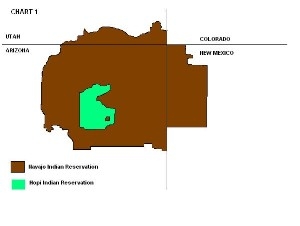
If you purchase a map of the American southwest, or a map of New Mexico. You will see that the Navajo Indian Reservation will look like this (Chart 1). The Arizona part of the reservation is quite huge and is the larger part of the reservation. The Utah side of the reservation is the smaller part of Navajoland. But the New Mexico side of the reservation, for the Navajo the map on Chart 1 is not true for our reservation extends farther out. For this part of the story of the Navajo Nation, I would like for you to pay close attention to the New Mexico side of the reservation. The New Mexico side of the reservation as with all of Native American history, is a very sad part of Navajo history.
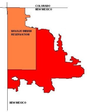 On the eastern boundary of the Navajo Reservation lies an area equal in size to
Delaware and Rhode Island combined. It is an area filled with deserts and mesas
and canyons, water is scarce in this area. On November 9, 1907, Theodore
Roosevelt issued an executive order to add this area to the Navajo Indian
Reservation. The map on the left shoes the tan colored area as part of the
Navajo Nation in 1907. The red area is what Theodore Roosevelt sign as part of
the 'new' Navajoland. An estimate of almost 3,000,000 acres. The Navajos were
happy and meant prosperity for the tribe. It was also a time of celebration
since this area is the most sacred of all Navajoland. It was the area of the
birthplace of the Navajo people, referring to a place called Huerfano. The
native inhabitants enjoyed this land, but unfortunately, not for long... New
Mexico was on the verge of statehood and talks of oil being found in that area
and greedy stockmen were waiting impatiently for President Roosevelt to leave
his term. When is presidency was over, a flood of oil men, politicians and
livestock went to Washington to pressure the new president, President Taft.
On the eastern boundary of the Navajo Reservation lies an area equal in size to
Delaware and Rhode Island combined. It is an area filled with deserts and mesas
and canyons, water is scarce in this area. On November 9, 1907, Theodore
Roosevelt issued an executive order to add this area to the Navajo Indian
Reservation. The map on the left shoes the tan colored area as part of the
Navajo Nation in 1907. The red area is what Theodore Roosevelt sign as part of
the 'new' Navajoland. An estimate of almost 3,000,000 acres. The Navajos were
happy and meant prosperity for the tribe. It was also a time of celebration
since this area is the most sacred of all Navajoland. It was the area of the
birthplace of the Navajo people, referring to a place called Huerfano. The
native inhabitants enjoyed this land, but unfortunately, not for long... New
Mexico was on the verge of statehood and talks of oil being found in that area
and greedy stockmen were waiting impatiently for President Roosevelt to leave
his term. When is presidency was over, a flood of oil men, politicians and
livestock went to Washington to pressure the new president, President Taft.
Just a short four years later, on January 16, 1911, President Taft restored the 3,000,000 acre 'new' Navajoland back to public domain. Immediately, the non-native stockmen found this area as 'free lands' again. And began taking over the area.
20% was owned by Santa Fe Railroad, 7% to the State of New Mexico and 4% to non-native homesteaders, 3% to the Arizona and New Mexico Land Company. all of these ownerships were scattered everywhere that only one could imagine. The area was referred to as the 'Checkerboard Area'. As lands in the area alternated to private, Navajoland, allotted, National forest and public lands. The problem in this area has become complex. Navajos began to call this area "Old Dinetah" or old Navajoland as it was no longer a part of the reservation.
In 1918, the New Mexico delegation to Congress secured the enactment of legislation to prevent further enlargement of the Navajo Reservation by Executive Order - providing for future enlargement only by Act Of Congress and, in 1919, general legislation was adopted, precluding the enlargement of any Indian reservation from the public domain except by Act Of Congress. On March 3, 1927, the Congress passed an Act which provided that no changes could thereafter be made in the boundary of any Indian reservation except by consent of Congress.
To the Navajo people, it was another 'lie' by Washington and found themselves living off of the Navajo Nation. It must have been something like a friend giving you a birthday present and four years later that friend comes up to you and asks for the gift back...
The BIA (Bureau Of Indian Affairs) began to allot the land to the Navajos living in the area, this was done so the tribe could hold on to the land. It was a good idea, but did not do so well... As a result, only 49% of this huge territory (2,154,550 acres) was owned by Navajos.
During the next six or something decades, numerous Orders and Public Land Orders were exchanged, bought, assigned and reassigned on this land base so that today, there are 8 separate land ownership categories ranging from private, federal, state to tribal lands so that today it looks scattered like a 'checkerboard'. Thus the name, Checkerboard Area.
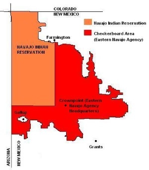 Even though since the land was revoked in 1911, and the Navajos regained only
forty nine percent, throughout the years the area managed to still be a part of
the Navajo Reservation. By meaning this, 31 chapters or Navajo communities
formed since then. Making this area the most communities of all Navajoland. The
tribe also managed to turn this area as part of their 'agency'. Crownpoint, New
Mexico is the Eastern Navajo Agency Headquarters. Angel Peak Recreation Area,
Bisti Badlands, and De-Na-Zin Wilderness and even Bluewater Lake State Park and
Red Rock State Park are part of the Navajo Nation since the area is surrounded
by the alloted Navajolands. The satellite reservations of Alamo, Ramah and Tohajiilee have been assigned to this part of the agency.
Even though since the land was revoked in 1911, and the Navajos regained only
forty nine percent, throughout the years the area managed to still be a part of
the Navajo Reservation. By meaning this, 31 chapters or Navajo communities
formed since then. Making this area the most communities of all Navajoland. The
tribe also managed to turn this area as part of their 'agency'. Crownpoint, New
Mexico is the Eastern Navajo Agency Headquarters. Angel Peak Recreation Area,
Bisti Badlands, and De-Na-Zin Wilderness and even Bluewater Lake State Park and
Red Rock State Park are part of the Navajo Nation since the area is surrounded
by the alloted Navajolands. The satellite reservations of Alamo, Ramah and Tohajiilee have been assigned to this part of the agency.
So our reservation DOES extend father out in New Mexico. It is called the Checkerboard Area. But if you look at the area (49%), I'd say the Navajos got at least half the area back. And it IS Navajoland, however we still feel discriminated today because as mentioned earlier, if you look at maps of New Mexico you will see the boundary of the Navajo Reservation looks like this:
Our reservation DOES NOT look like that... That is why when you visit Navajoland, our maps that we hand out to tourist will look like this:
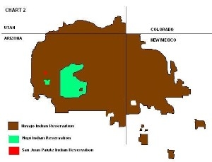
This is the current boundary of Navajoland. Our reservation DOES NOT end outside of Farmington, New Mexico. It extends out towards Bloomfield, New Mexico and touches the Jicarilla Apache Indian Reservation and ends 15 miles away from Cuba, New Mexico, some 90 miles away from Farmington. And ends 15 miles away from Grants, New Mexico. then toward Gallup and surrounds this community, touching the northern border of the Zuni Indian Reservation.
I hope you understand a little more about the New Mexico side of the reservation and why it is called the Checkerboard Area.
I'm probably sure that some of you are disagreeing, but if you take time to cruise through the checkerboard area; I would like to ask you how many non-native landowners can you see out in that area? A few, maybe 500 or a 1,000... But that is nothing compared to the 30,000 Navajos living in the area. That area is also dominated by 31 Navajo communities. You will see hogan scattered throughout that isolated area.
Yes, there are two sides to every story, a non Navajo might refer to this area as not being part of the Navajo Reservation. But to a Navajo... This is Navajoland...
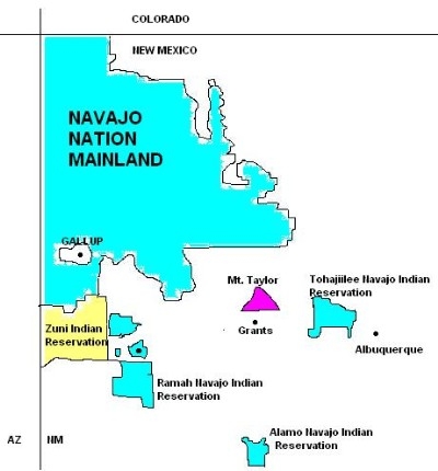
In addition to the main reservation, we have 3 other smaller reservations or what we call satellite reservations. For example, it's like Alaska and Hawaii, they're a part of the United States but located farther away. All three satellite reservations are located in New Mexico.
Located 15 miles west of Albuquerque, is the Canoncito Band of Navajos, they live on the Canoncito Navajo Indian Reservation (77,965.02 acres/ 120 square miles), they have 2,683 members. Canoncito Navajoland in the Navajo language is To' hajileehi' which means: Lifting water (Up by rope and container).
South of Gallup are the Ramah Band of Navajos, they live on the Ramah Navajo Indian Reservation (167,656.03 acres/ 229 square miles), they have 3,216 members. Ramah Navajoland in the Navajo langauge is Tl' ohchini' which means: Place of wild onion.
Farther south near Magdalana, are the Alamo Band of Navajos, they live on the Alamo Navajo Indian Reservation (65,028.32 acres/ 98 square miles), they have 1,942 members. Alamo Navajoland in the Navajo language is T' iistsoh' sikaadi' which means: Big Cottonwood.
Each of these three bands elect their own tribal president and their tribal laws are different than those on the main reservation because they have special land status, meaning the band controls their land, not the Navajo Nation. Canoncito Navajo is in the process of "breaking away" from the main body to become an independant tribe. They have had permission to break free from the Nation but it is Congress and the United States that has yet provided separate recognition to the band. So they continue to be governed by the laws of the Navajo Nation. Alamo and Ramah are still hanging on the the main body and all three of the Bands are enrolled into the larger part of the Tribe and participate in Navajo Governments.
Tohajiilee Band Of Navajos
Canoncito Band of Navajos have separated from the tribe back in the 1500's to
follow the missionary way of life when missionaries were allowed to preach to
the tribe. Although many members disregarded this new religion and continued
northward toward their traditional homeland in the Four Corners, a small group
of Navajos stayed because they found it much easier to believe in one god rather
than the many Navajo Gods and Goddesses. They formed a community where they
still live today since breaking away from the main tribe back in the 1500's.
They are the most Christians of the entire Navajo Nation. The Canoncito Navajo
Reservation is recognized by the Federal government as the "Canoncito Band of
Navajo Indians". It does operate to some degree of autonomy, including direct
dealing with the federal funding sources. For example, Canoncito gets direct
funding under Title IV of the JTPA. However, under state flow-through JTPA
funding, Canoncito receives its share of Title III funds by way of the Navajo
Nation Government. Influenced by Indian gaming, the Canoncito Navajo Band has
strived to build a casino on their land. The Navajo Nation Council has approved
only the Canoncito Navajo Chapter to build a casino on their land. Tribal
leaders for the Navajo offshoot claim building a casino will help their chapter,
their land and mostly their people. They say their needs are always ignored by
the big Navajo because they are a satellite community, two hours away from the
main Navajo Reservation. In 1999 the community of Canoncito officially changed
their name from Canoncito to To' hajiilee. Canoncito Navajo Indian Reservation
was established in 1949.
Ramah Band Of Navajos
The Ramah Band of Navajos, according to elder Ramah Navajos, have lived in the area which is the Zuni Mountains and the Ramah valley and even herded their livestock as far south as Reserve, New Mexico. Herding their livestock before the Long Walk of 1864. They claimed to have lived in the area since the 1500s. The area is called Tlo 'chini which translates as Place of wild onions. To the west of their reservation is Zuni Pueblo, the two lands touch each other. At the other side of the Ramah Navajoland is El Morro National Monument, where Spanish explorers carved their names in the sandstone rock long before the Pilgrims landed at Plymouth Rock. The founders of this certain part of land were removed to Fort Sumner along with other Navajos. They were kept prisoners and well as slaves during the four year period (1864-1868) and were finally released on June 1, 1868. Seven of the original families returned to the Ramah area only to find their land occupied by non-Indians. Even though the Ramah area was not part of the new Navajo reservation set out in the original 1868 treaty, they remained in the area anyway. Many Beads was at the time leader of the Ramah Band of Navajos. Travelers mentioned the Navajos living in the Ramah area during the 1800's, and soon Mormon settled there for irrigation purposes. Anglo settlers sought land under the Homestead Act of 1887. At the time Indians were not recognized as U.S. citizens so it did not apply to them. The settlers entered the 'open range' area which was already occupied by the Ramah Navajos. But did not care to notice them, suddenly the Ramah Navajos found themselves under Anglo-American law. The U.S. government continue to displace the Ramah Navajos by pushing them south of the farming land. Which they pushed them so far as they found themselves trying to farm on lava land, or 'malpais' which made grazing and farming difficult. They were pushed away from water resources and into the very edge of the Ramah area. No legal title to land for the Ramah Band was acquired until 1920. This was at the time when the Ramah Navajo Reservation began to take shape. In 1920, Bidagaa, the son of Many Beads, now Ramah headman, and other Navajo leaders from the main reservation such as Chee Dodge traveled to Washington D.C. to address land issue of the Ramah area. Washington did not listen...
In 1934 a bill called Senate Bill 2531 was introduced to create a land base for the Ramah Band, but did not pass the Senate floor. Although Federal government leased lands on behalf of the Ramah Band in the 1930's, non-Indian ranchers and settlers petitioned to nave the land opened up for sale and the Government heeded their request. Because of that, the Arizona and New Mexico Land Company began selling off large quantities of land, some of which was leased by Ramah Navajos. At this time, the Ramah Band of Navajos had become strongly aware and needed protection and rights to insure their survival. Many pleads were made to the main body of the Navajo Tribe, but to no avail since they lived outside of the Reservation boundary. With no help even from the main Navajo Tribe, they turned to the United Pueblo Agency of the BIA to find a way to secure land for the Band. Finally on August 28, 1944, the Picuris Pueblo purchased 26,726.28 acres (Section 25, 27, 29, 31, 33 & 35) and the Pojoaque Pueblo purchased 28,886.16 acres (Section 1 to 23 including T8N.R14W Twps. 7 & 8, R15W) for the Ramah Band of Navajos at $2.00/acre from the New Mexico and Arizona Land Company (total acres 55,612.44 acres). This land was leased by the Pueblo to the Ramah Band at eight cents per acre. Final arrangements were made to purchase the land through the main Navajo Tribe, on behalf and for the sole use of the Ramah Band of Navajos. In the early 1960's the Navajo Tribal administration under the chairmanship Raymond Nakai determined that all past purchases of land by the Tribe would be governed by the Tribe, not the Ramah Band. Which to this day has caused difficulties for the Band.
Because of Ramah Band's geographic separation from the main Navajo Tribe, the Band has historically been ignored by the Tribe and by Navajo Service in Window Rock. As a result, the Band have taken their welfare into their own hands and related to the Navajo Tribe in a semi-autonomous fashion and established a direct government-to-government relationship with the federal government. Finally in 1972, the Ramah Navajos received its own BIA agency. Until then it had been under the Southwest Regional Office (formerly Albuquerque Area Office) along with the 19 pueblos, including the Jicarilla and Mescalaro Apache Tribes and was NEVER under the Navajo Area Office. However even with a neglect from the main tribe, they managed to be a chapter of the Navajo Nation. Ramah Navajo is the only chapter with its own BIA Agency. Since 1986, the Ramah Navajo Chapter successfully contracted programs for a number of services previously operated by the BIA. The programs provided are entirely separate from programs offered by the Navajo Nation on the Navajo Reservation for its other chapters.
Alamo Band Of Navajos
Like Ramah, the Alamo Band of Navajos didn't form until after the Long Walk. The
story goes is that a small group of Navajo slaves escaped slavery from the
Mexicans and fled to a mountainous area now called Cibola National Forest;
almost half of the Alamo Navajoland lies within Cibola National Forest. They hid
in the forest and built camps near a river which they used to survive. When the
Navajos were released in 1868, the runaways returned to the main body of the
tribe to retreive their relatives. They convinced them to return to the forest
with them. Other members hearing of this conversation returned with them because
they were afraid the same thing would happen to them (Fort Sumner). A leader was
formed within the newly formed band and the small camp grew into a community.
Isolation is felt to be the main drawback on the Alamo Navajo Reservation. This
has impacted on education and socioeconomic conditions of the reservation and
created gaps between Alamo Navajo and the Navajo Nation as well as with the
American mainstream. Alamo is situated 220 miles southeast of the Navajo Nation
capitol of Window Rock. It is 30 miles from the border town of Magdalana, New
Mexico, a town of about 861 people. The reservation is generally semi-arid,
range land, some rolling hills, badlands, volcanic rock formations, and
mountains. The Alamo Navajo Indian Reservation was established in 1946.
Long before Congress divided the land and relocated Navajos and Hopis, there was another relocation for the Navajos and Hopis back in the 1940's that very few people know about known as the War Relocation Authority...
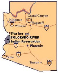 The Colorado River Indian Reservation is 269,921 acres and its boundary lines
extends into the states of Arizona (La Paz County) and California (San Bernadino
and Riverside Counties). The Colorado River Indian Reservation was established
on March 3, 1865, for the "Indians of said river and its tributaries."
Reservation lands include almost 270,000 acres along both sides of the Colorado
River between Parker, Arizona, and Blythe, California. Of the total acreage,
225,996 acres lie in Arizona and 42,696 acres are located in California. The
Colorado River Indian Tribes Reservation is home to four tribes. The original
inhabitants are the Mohave Tribe and the Chemehuevi Tribe, who were later joined
by relocated Navajos and Hopis after World War II. After World War II, the
United States government developed a theory of surplus Indian population, such
that where the land base was considered insufficient to support the total number
of tribal members, the "surplus" would be moved off the land. In the case of the
Colorado River Indian Reservation, people from the Navajo and Hopi Reservations
were offered farming lands on the reservation (Colorado River Reservation);
these tracts included both traditional Mohave and Chemehuevi lands and some that
were previously developed under the War Relocation Authority. With the total of
four tribes living on one reservation, the 1990 Census revealed 3,098 members
living on the Colorado River Indian Reservation. The 'lost' Navajos ceded from
the Navajo Nation and are recognized under the Colorado River Indian Tribes
Confederacy.
The Colorado River Indian Reservation is 269,921 acres and its boundary lines
extends into the states of Arizona (La Paz County) and California (San Bernadino
and Riverside Counties). The Colorado River Indian Reservation was established
on March 3, 1865, for the "Indians of said river and its tributaries."
Reservation lands include almost 270,000 acres along both sides of the Colorado
River between Parker, Arizona, and Blythe, California. Of the total acreage,
225,996 acres lie in Arizona and 42,696 acres are located in California. The
Colorado River Indian Tribes Reservation is home to four tribes. The original
inhabitants are the Mohave Tribe and the Chemehuevi Tribe, who were later joined
by relocated Navajos and Hopis after World War II. After World War II, the
United States government developed a theory of surplus Indian population, such
that where the land base was considered insufficient to support the total number
of tribal members, the "surplus" would be moved off the land. In the case of the
Colorado River Indian Reservation, people from the Navajo and Hopi Reservations
were offered farming lands on the reservation (Colorado River Reservation);
these tracts included both traditional Mohave and Chemehuevi lands and some that
were previously developed under the War Relocation Authority. With the total of
four tribes living on one reservation, the 1990 Census revealed 3,098 members
living on the Colorado River Indian Reservation. The 'lost' Navajos ceded from
the Navajo Nation and are recognized under the Colorado River Indian Tribes
Confederacy.
The Navajo Nation rejected the Indian Reorganization Act of 1934, and so is not organized under that act. It is governed by a council consisting of 88 members, representing the 110 chapters that make up the Navajo Nation; twelve standing committees conduct business between the full council sessions, which are held quarterly. The Navajo Nation has a three-branch government, similar to that of the United States. The executive branch is headed by a tribal president, chosen by popular election every four years. During that same election year, the 88 council delegates are elected. Every two years, the council decides on a "speaker," who presides over all council sessions, in addition to administratively overseeing the legislative branch. The judicial branch is headed by a chief justice who is nominated by the president and confirmed by the council; it consists of a supreme court, seven district courts, and seven family courts, in addition to the traditional peacemaker courts. Each of the 110 chapters also has a president, vice-president, secretary-treasurer, and grazing committee member, elected every four years.
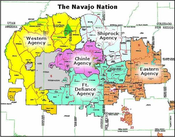
Due to the extremely large size of Dinetah (Navajoland), in the 1920's, Navajo leaders divided the vast reservation into 5 agencies. The agencies act like counties while the reservation acts like a state. The 110 chapters are divided among the agencies, chapters are the Navajo communites that make up the boundaries of the Navajo Indian Reservation. The five agencies are: Western Navajo Agency, Shiprock Agency, Chinle Agency, Fort Defiance Agency, Eastern Navajo Agency. The largest is the Western Navajo Agency with 5,559,620.80 acres. The second largest is the Eastern Navajo Agency with 3,363,519.68 acres (this also includes the 3 satellite reservations: Alamo, Canoncito, Ramah.) Fort Defiance Agency is the third largest with 3,178,931.16 acres. Shiprock Agency is next with 2,726,437.85 acres. The smallest is Chinle Agency with 1,881,648.54 acres. The northern most chapter is Aneth, Utah. The southern most chapter is Alamo, New Mexico. The western most chapter is Cameron, Arizona. The eastern most chapter is Tohajiilee, New Mexico.
The picture on left is a photoshot of Bisti Badlands.The Eastern Agency has more Navajo communites than other areas of Navajoland. This vast area is also the most sacred of all places on Navajoland since it is the birthplace of the Navajo people. The huge isolated areas are filled with deserts, canyons and mesas. Bluewater Lake State Park, Chaco Culture National Historic Site, Angel Peak Recreation Area, Bisti Badlands, Red Rock State Park are the Eastern Navajo Agency's sight seeing tours. Gallup, New Mexico is also located in this area, though it is not on the reservation but it is surrounded by the boundaries of Navajoland. Gallup is known as the "Gateway to the Navajo Nation". This side of the reservation shares its borders with the Zuni Pueblo which is located about 30 miles south of Gallup, in that area are the chapters of Red Rock, Breadsprings and Chichiltah. It also shares its border with the Jicarilla Apache Nation located near the chapter of Counselor. The eastern Navajo agency is the second largest agency on the reservation. Ramah, Alamo and Tohajiilee Navajo Reservations lie in this area.
EASTERN NAVAJO AGENCY
3,363,519.68 Acres
Agency Headquarters: Crownpoint
31 Chapters
Monuments And Parks And Attractions:
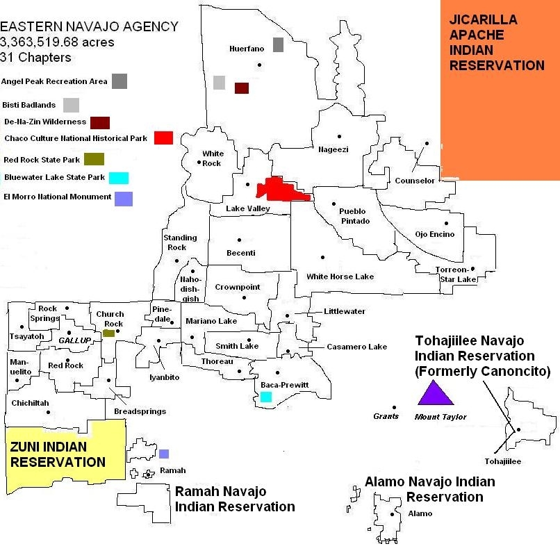
Chapter - Estimated Land Size - Date Certified
Alamo - 65,028.32 acres - April 26, 1957
T'iis' Tsoh: Big Cottonwood
P.O. Box 827
Magdelena, NM 87825
Phone: (505) 854-2686
Fax: (505) 854-2685
Distance to Crownpoint Agency: 147 miles
Distance to Window Rock: 221 miles
Alamo Navajo Reservation is the farthest away from the bigger Navajo Reservation, but surprisingly it is not the farthest from the tribal capital of Window Rock, Arizona. It is 221 miles away from the capital. But it is the chapter of Navajo Mountain, Utah that is the farthest from Window Rock with 226 miles away. It is located off of I-25 from the town of Soccoro and then turn west on US Hwy 60 for about 25 miles to Magdalena. Then turn north on State Hwy 169 another 25 miles to Alamo. Stories about Alamo vary from the main Navajo Nation to the people of Alamo themselves. Navajo Nation has stories about them escaping Ft. Sumner, while the descendents of Alamo claim they have lived in the area long before the Long Walk. There are some hogans in the area dating back before the Long Walk period. Alamo is a unique community because the Navajos here have their very own four sacred mountains! Magdalena Mts, Ladron Peak, Quemado Mts and Mogollon Mts. and they speak a different dialect of the Navajo language. Probably because of their intermarriage with the Apache who also resided in the area some time ago, and the Apache speak a similar language of the Navajo. As with Tohajiilee and Ramah chapters, the other satellite reservations, they have a history of being ignored by the big reservation. The Alamo Navajo Indian Reservation was established in 1946, but didn't become a certified chapter of the Navajo Nation until 1957.
Baca - 127,153.10 acres - December 5, 1955
Kin Ligaai: White house
P.O. Box 563
Prewitt, NM 87045
Phone: (505) 876-9917
Fax: (505) 285-4221
Distance to Crownpoint Agency: 35 miles
Distance to Window Rock: 68 miles
Baca-Prewitt chapter is the easternmost part of the reservation. It is located 19 miles away from Grants, New Mexico. And it is 43 miles away from Gallup, the border town. Bluewater Lake State Park lies in this part of the chapter area. It is located 7 miles south off of I-40. In 1916, Bob and Harold Baca opened up a trading post in which the Navajos living in the area called the community Baca. Mount Taylor, one of the four sacred mountains, can be seen as it is located near Grants.
Becenti - 193,752.40 acres - February 14, 1956
Jadi Hadit'iih': Lookout for antelope
P.O. Box 708
Crownpoint, NM 87313
Phone: (505) 786-2283
Fax: (505) 786-2285
Distance to Crownpoint Agency: 18 miles
Distance to Window Rock: 75 miles (Via Navajo Route 9)
Becenti is located just off of New Mexico State Highway 371. The area lies in the checkerboard area as much of the Eastern Navajo Agency is. The area is filled with canyons and mesas and little vegetation. The community was named after Chief Becenti, the first known leader of the area. Local meetings were held at different places until a chapter house was built and the area was certified as a chapter in 1956.
Bread Springs - 49,273.22 acres - March 20, 1956
Baah Haali: Bread flowing about
P.O. Box 3008
Gallup, NM 87301
Phone: (505) 778-5796
Fax: (505) 778-5915
Distance to Crownpoint Chapter: 76 miles
Distance to Window Rock: 44 miles
Breadsprings is located inbetween Gallup and the Zuni Pueblo Reservation. It is an area mixed with forests and rolling hills. The chapter is located outside the boundary of the Cibola National Forest. From I-40 to south of the Zuni Pueblo, four chapters share this little area part of the Navajo Nation; Breadsprings, Manuelito, Red Rock and Chi-chil-tah.
Casamero Lake - 47,230.66 acres - February 14, 1956
Tseta' To Ak'oli: Water waves among the rocks
P.O. Box 549
Prewitt, NM 87045
Phone: (505) 786-5273
Fax: (505) 786-7078
Distance to Crownpoint Agency: 26 miles
Distance to Window Rock: 73 miles
Casamero Lake is one of those hidden chapters of the Navajo Nation. It is located off of Navajo Route 48E. It is located behind a mesa. Tucked in a corner of this mesa is Borrego Pass Trading Post. It is the only convenience store in the area, otherwise Crownpoint is the nearest larger community, some 15 miles away. The road to Casamero Lake is not paved so it can be unpassable at some times. Navajo Route 48E continues on towards I-40 some 10 miles away and meets with its neighboring chapter Baca-Prewitt. Mount Taylor can be seen in the distance.
Chichiltah - 132,754.50 acres - December 5, 1955
Chech' iltah: Among oak trees
No address or phone given
Distance to Crownpoint Agency: 83 miles
Distance to Window Rock: 50 miles
Chichiltah Chapter shares its southern border with the Zuni Pueblo Indian Reservation. It is located 8 miles off of Navajo Route 7044 and 30 miles south of Gallup of of New Mexico Highway 32. The area is a flat prairie land and some oak trees are in the area. Some Anasazi sites can be found in the area.
Church Rock - 52,719.15 acres - December 5, 1955
Tse Daa T'ees: Group of yellow houses
P.O. Box 549
Churchrock, NM 87311
Phone: (505) 488-5949
Fax: (505) 488-6561
Distance to Crownpoint Agency: 47 miles
Distance to Window Rock: 34 miles
Church Rock is about 6 miles east of Gallup. Sometimes Church Rock is referred to not as a community but as a village, due to its small residence. The area is named after a red and white sand stone rock resembling a multi-steepled church. This rock is important to the Navajo people as it is mentioned in the Coming Up Side Ceremony or Moving Upwardway Ceremony (Haneelne'ehee). Red Rock State Park is located in this area.
Counselor - 78,770.38 acres - May 1, 1974
Bilagaanasneez: Tall white man
P.O. Box 209
Counselor, NM 87018
Phone: (505) 568-4311
Fax: (505) 568-4311
Distance to Crownpoint Agency: 66 miles
Distance to Window Rock: 133 miles
Just off the road of New Mexico State Highway 44 is Counselor. The eastern tip of the chapter border touches the Jicarilla Apache Indian Reservation. The area is named after Jim Counselor, who owned a trading post and served the Navajos and Jicarilla Apaches back in the winter of 1922-23. Counselor is located in the middle of nowhere as the nearest major community is Cuba, 33 miles east. Farmington is 66 miles west of the chapter. As with all of the eastern agency, the land is part of the Checkerboard Area, as Lybrook Oil Refinery is located in the area. Alternating blocks of land are owned by the Navajo Nation, Navajo individuals and parts are owned by ranchers, oil companies, and open land.
Crownpoint - 67,363.91 acres - January 20,1965
T'iists' ooz: Narrow trees in canyon
P.O. Box 336
Crownpoint, NM 87313
Phone: (505) 786-2130
Fax: (505) 786-2136
Distance to Crownpoint Agency: 0 miles
Distance to Window Rock: 68 miles (Via Navajo Route 9)
Crownpoint is the headquarters for the eastern area of the reservation. It is the only largest community in eastern Navajoland. As with all chapters in this area, developing is difficult due to the checkerboard area.
Huerfano - 548,328.80 acres - February 15, 1956
Dzil Na' oodillii: Whirling mountain
P.O. Box 968
Bloomfield, NM 87413
Phone: (505) 325-1400
Fax: (505) 326-3044
Distance to Crownpoint Agency: 54 miles
Distance to Window Rock: 107 miles
Dzil Na 'Oodilii is the second largest chapter on the Navajo Nation. The Navajo
Agricultural Product Industries is located in this area. Carson, Otis, Bisti,
Adobe, Gallegos, Blanco and Jaquez communities all lie within the chapter. Angel
Peak Recreation Area, which is 8 miles south of Bloomfield is an area filled
with mesas, buttes and badlands, there are a few picnic tables near the
overlook. Located off of State Highway 371, 40 miles south of Farmington is the
Bisti Badlands. Much of the Bisti landscapes bears surface coals, strip mining
is in progress. Part of the Badlands has been set aside as a reserve national
park. Bisti is filled with strange rock formations, one of Navajoland's hidden
treasures. Two miles east of Bist is De-Na-Zin Wilderness Area. It is larger
than Bisti, but a less scenic. Huerfano was certified as a chapter in 1956, but
the first chapter house was built in 1957.
Iyanbito - 29,136.45 acres - December 2, 1955
Ayani Bito': Buffalo's water
P.O. Box 498
Fort Wingate, NM 87316
Phone: (505) 488-5650
Fax: (505) 488-6155
Distance to Crownpoint Agency: 47 miles
Distance to Window Rock: 45 miles
Located just a few miles west of Gallup, the entrance to the community is by crossing railroad tracks. The community sits next to red bluffs in the area. Interstate Highway 40 lies next to the community.
Lake Valley - 83, 573.47 acres - February 14, 1956
Be'ak'id Halgaai: White flat area of lake
P.O. Box 190
Crownpoint, NM 87313
Phone: (505) 786-2190/2191
Fax: (505) 786-2192
Distance to Crownpoint Agency: 29 miles
Distance to Window Rock: 96 miles (Via Navajo Route 9)
Located off of State Hwy 371, it is a community that is located out in the middle of nowhere. With Crownpoint being almost 30 miles away south and Farmington also being 30 miles north. The area lacks electricity and other modern equipment. However, there is a school in the area. The area has little vegetation and rolling mesas can been seen for miles around. Chaco Culture National Historical Park lies in the chapter boundary but it is Nageezi that is the gateway to the park since it is located closer.
Littlewater - 67,461.90 acres - October 26, 1955
To Alts'isi: Small amount of water
P.O. Box 1898
Crownpoint, NM 87313
Phone: (505) 786-2120/2121
Fax: (505) 786-2125
Distance to Crownpoint Agency: 16 miles
Distance to Window Rock: 83 miles (Via Navajo Route 9)
Littlewater; the name says it all. Even in the Navajo language meaning, "small amount of water". The community residence hauls water from other sources than from their own chapter, such as Crownpoint, some 16 miles away. There are riverbeds in the area, but it is dry most of the time. At times, during a rainstorm the dry riverbeds will be running with water.
Manuelito - 56,758.38 acres - February 5, 1955
Kin Hozhon'i: Beautiful house
HCR 57, Box 9069
Gallup, NM 87301
Phone: (505) 722-3073
Fax: (505) 722-6060
Distance to Crownpoint Agency: 78 miles
Distance to Window Rock: 35 miles
Manuelito is located on the New Mexico side of the Arizona-New Mexico border off of I-40. It is about 20 miles away from Gallup. Manuelito is in the checkerboard area, so development is difficult in this area. However the chapter is currently pursing to have a casino built on their land. There is railroad tracks that pass through the area so often a train can be seen passing through Navajoland. The area is flat with red mesas and rocks jutting out of the area. There are numerous backroads and dirt roads but most of these leads to private homes.
Mariano Lake - 67,138.83 acres - December 2, 1955
Be'ak'id Hoteeli: Wide lake
No address or phone given
Distance to Crownpoint Agency: 24 miles
Distance to Window Rock: 57 miles
Mariano Lake is located off of State Hwy 57/371 off of Smith Lake and turning west on Navajo Route 49. On this backroad to Gallup, there are a couple of hidden chapters such as Mariano Lake, and it's neighboring chapter, Pinedale. The area has some hills and trees and the red bluffs that stretch from Gallup all the way to Thoreau can be seen.
Nageezi - 221,748.80 acres - December 2, 1955
Naayizi: Squash/Pumpkin
P.O. Box 100
Nageezi, NM 87037
Phone: (505) 632-7200
Fax: (505) 632-7201
Distance to Crownpoint Agency: 67 miles
Distance to Window Rock: 135 miles
Naayizi is located next to the massive neighboring Huerfano Chapter. It is
located 36 miles south of Bloomfield. The area is isolated. Oil and gas are the
local natural resources for this chapter. Nageezi is the entrance way to the
world famous Chaco Culture National Historic Park.
Nahodishgish - 63,514.73 acres - December 5, 1955
Nahodeeshgiizh: Cross sections of canyons
P.O. Box 369
Crownpoint, NM 87313
Phone: (505) 786-2028
Fax: (505) 786-2370
Distance to Crownpoint Agency: 12 miles
Distance to Window Rock: 58 miles (Via Navajo Route 9)
On Navajo Route 9 lies Nahodishgish. Like much of the communities, the area lacks water and electricity. And is located 12 miles away from the larger community of Crownpoint. The community is isolated so emergency services are not realized fast enough. The area is flat. With an endless sight of a Navajoland desert.
Ojo Encino - 78,770.38 acres - June 13, 1957
Chech'il Biyaadoo To Deezli: Water within rough rock
HCR 79, Box 1500
Cuba, NM 87013
Phone: (505) 731-2263
Fax: (505) 731-2263
Distance to Crownpoint Agency: 72 miles
Distance to Window Rock: 139 miles
Ojo Encino is located off of Navajo Route 47. It's nearest town is Cuba, 30
miles away. Tsech'izhi bii'to is one of the few chapters that is isolated.
Getting to Ojo Encino can be confusing on Navajo Route 47. Easiest way is from
the chapter of Counselor. Turn off to Navajo Route 46. It is a dirt road
(backroad country), come to where the road splits to Navajo Route 47A. Follow it
for about 10-15 miles. When you see the water tower, you'll find Ojo Encino.
Pinedale - 40,949.96 acres - December 2, 1955
To Beehwiisgani: Harden mud around the water
P.O. Box 3
Church Rock, NM 87311
Phone: (505) 786-2208
Fax: (505) 786-2211
Distance to Crownpoint Agency: 31 miles
Distance to Window Rock: 52 miles
Pinedale is one of Navajo Nation's smallest chapter and is tucked away on the backroads of Navajo Route 49. The area is isolated with rolling green hills. Development is difficult due to the Checkerboard area.
Pueblo Pintado - 189,639 acres - February 14, 1956
Nahodeeshgiizh Ch'inilini: Water flowing from canyon
HCR 79, P.O. Box 3026
Cuba, NM 87013
Phone: (505) 655-3221
Fax: (505) 655-3221
Distance to Crownpoint Agency: 43 miles
Distance to Window Rock: 107 miles (Via Navajo Route 9)
Pueblo Pintado is one of the easternmost chapters along with White Horse, Counselor and Ojo Encino and Torreon-Star Lake. These are the chapters that make up the extreme edge of the eastern border of the main Navajo Nation. Tohajiilee is located further towards Albuquerque, but is a satellite reservation with it's own land boundaries. In this extreme edge of the eastern border is an area where little vegetation grows and the area is dominated by mesas and bluffs and little trees. A perfect example of the American southwest desert.
Ramah - 167,656.03 acres - October 31, 1957
Tl'ohchini: Place of wild onion
Route 2, P.O. Box 13
Ramah, NM 87321
Phone: (505) 775-7140/7142
Fax: (505) 775-7137
Distance to Crownpoint Agency: 112 miles
Distance to Window Rock: 78 miles
Ramah Navajo Reservation is the largest satellite reservation located away from the big Navajoland. Tohajiilee is next in size and Alamo Navajo Reservation is the smallest. Ramah has had a history of being independant from the main body of the tribe.
Red Rock - 42,364.55 acres - November 10, 1955
Tse Lichii: Red rock
P.O. Box 2548
Gallup, NM 87301
Phone: (505) 722-8071/8135
Fax: (505) 722-0625
Distance to Crownpoint Agency: 64 miles
Distance to Window Rock: 30 miles
Rock Springs - 27,020.08 acres - December 5, 1955
Tse ch' izhi: Rough rock in texture
P.O. Box 4608
Yah-Ta-Hey, NM 87375
Phone: (505) 371-5407
Fax: (505) 371-5531
Distance to Crownpoint Agency: 54 miles
Distance to Window Rock: 17 miles
Smith Lake - 37,644.16 acres - December 5, 1955
Tsin Nazbas Si'a: Rounded wood
P.O. Box 60
Smith Lake, NM 87365
Phone: (505) 786-2138
Fax: (505) 786-2143
Distance to Crownpoint Agency: 13 miles
Distance to Window Rock: 70 miles
Standing Rock - 74,104.34 acres - February 14, 1956
Tse li' ahi: Standing rock
P.O. Box 247
Crownpoint, NM 87313
Phone: (505) 786-2248/2247
Fax: (505) 786-2249
Distance to Crownpoint Agency: 16 miles
Distance to Window Rock: 51 miles (Via Navajo Route 9)
Thoreau - 31,190 acres - December 5, 1955
Dlo' ayazhi: Little praire dog
P.O. Box 899
Thoreau, NM 87323
Phone: (505) 862-0139
Fax: (505) 862-7150
Distance to Crownpoint Agency: 24 miles
Distance to Window Rock: 58 miles
Tohajiilee (Formerly called Canoncito) - 77,965.02 acres - December 5, 1955
To Hajiileehe: Lifting water up by rope and container
P.O. Box 336
Crownpoint, NM 87313
Phone: (505) 786-2130
Fax: (505) 786-2136
Distance to Crownpoint Agency: 111 miles
Distance to Window Rock: 142 miles
The Tohajiilee Navajo Reservation is recognized by the Federal government as the "Canoncito Band of Navajo Indians". It does operate to some degree of autonomy, including direct dealing with the federal funding sources. For example, Canoncito gets direct
funding under Title IV of the JTPA. However, under state flow-through JTPA
funding, Canoncito receives its share of Title III funds by way of the Navajo
Nation Government. Influenced by Indian gaming, the Canoncito Navajo Band has
strived to build a casino on their land. The Navajo Nation Council has approved
only the Canoncito Navajo Chapter to build a casino on their land. Tribal
leaders for the Navajo offshoot claim building a casino will help their chapter,
their land and mostly their people. They say their needs are always ignored by
the big Navajo because they are a satellite community, two hours away from the
main Navajo Reservation. In 1999 the community of Canoncito officially changed
their name from Canoncito to To' hajiilee. Canoncito Navajo Indian Reservation
was established in 1949.
Torreon-Star Lake - 118,832 acres - November 10, 1955
Na' Neelzhiin: Marked in dark
P.O. Box 1024
Cuba, NM 87013
Phone: (505) 731-2336
Fax: (505) 731-2336
Distance to Crownpoint Agency: 68 miles
Distance to Window Rock: 135 miles (Via Navajo Route 9)
Tsayatoh - 80,233.59 acres - March 20, 1956
Tseyaa To: Water beneath the rock
No address or phone given
Distance to Crownpoint Agency: 75 miles
Distance to Window Rock: 18 miles
White Horse Lake - 312,288.30 acres - December 2, 1955
Liilgaii Bito': White horse's water
HCR-79, P.O. Box 4069
Cuba, NM 87013
Phone: (505) 655-5430/5431
Fax: (505) 655-5432
Distance to Crownpoint Agency: 30 miles
Distance to Window Rock: 97 miles (Via Navajo Route 9)
White Rock - 110,162.80 acres - February 14, 1956
Tselgaii: White rock
P.O. Box 660
Crownpoint, NM 87313
Phone: (505) 320-8302
Fax: None
Distance to Crownpoint Agency: 35 miles
Distance to Window Rock: 102 miles (Via Navajo Route 9)
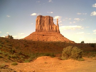
This photo is Monument Valley. Western Navajoland is the most scenic part of Dinetah and the most visited areas. Little Colorado River Gorge Navajo Tribal Park, Marble Canyon Navajo Tribal Park, Antelope Point Marina, Antelope Canyon Navajo Tribal Park, Lake Powell Navajo Tribal Park, Rainbow Bridge National Monument, Navajo National Monument, Monument Valley Navajo Tribal Park, Paiute Farms Navajo Recreation Area, Painted Desert Navajo Park, Grand Falls; all these lie within the western areas of Navajoland. The Grand Canyon is also located just outside the western border of this region. This part of the reservation shares its border with the Hopi Tribe as their entire reservation is surrounded by Navajoland. The San Juan Paiute Tribe recently was given about 5,000 acres of their own reservation land on Western Navajoland. Two parcels, one located 10 miles north of Tuba City, the western headquarters for the Navajo Nation. The other parcel for the San Juan Paiute Tribe is located in Utah. The chapters located here are the larger chapters of the entire reservation, such as Navajo Mountain and Coalmine Mesa and Oljato and more. Western Navajoland is the largest agency on the reservation. Bodaway-Gap chapter lies in this area also as it is the largest chapter on the 27,000 square mile reservation with 589,990.60 acres.
WESTERN NAVAJO AGENCY
5,559,620.80 Acres
Agency Headquarters: Tuba City
18 Chapters
Monuments And Parks And Attractions:
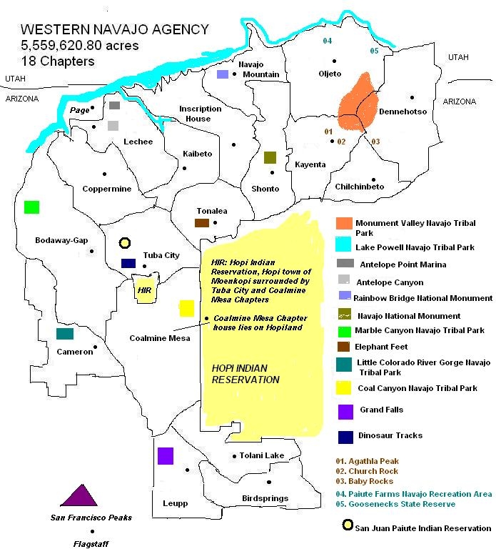
Chapter - Estimated Land Size - Date Certified
Birdsprings - 194,587.80 acres - December 5, 1955
Tsidii Toii: Bird's water(ing point)
HC 61, Box K
Winslow, AZ 86047
Phone: (928) 686-3267/3268
Fax: (928) 686-3269
Distance to Tuba City Agency: 121 miles
Distance to Window Rock: 114 miles
Bodaway/Gap - 589,990.60 acres - February 15, 1956
Tsinaabaas Habitiin: Inclined trail for wagons
No address or phone given
Distance to Tuba City Agency: 28 miles
Distance to Window Rock: 186 miles
Cameron - 238,522.70 acres - March 21, 1958
Na'Ni'a: Old structure across (old metal suspension bridge)
No address or phone given
Distance to Tuba City Agency: 26 miles
Distance to Window Rock: 184 miles
Chilchinbeto - 242,948.70 acres - December 5, 1955
Chiilchin Bii' To: Sumac spring
P.O. Box 1681
Kayenta, AZ 86033
Phone: (928) 697-3436/3413
Fax: (928) 697-8340
Distance to Tuba City Agency: 94 miles
Distance to Window Rock: 116 miles
Coalmine Mesa - 453,292.20 acres - October 26, 1955
Leejin Haageed: Digging out coal
P.O. Box 1464
Tuba City, AZ 86045
Phone: (928) 283-3383/3384
Fax: (928) 283-3385
Distance to Tuba City Agency: 24 miles
Distance to Window Rock: 134 miles
The original land size before partioned to the Hopi Tribe was 676,582 acres for the chapter of Coalmine Mesa.
Coppermine - 238,901.60 acres - November 10, 1955
Beesh Haageed: Digging out metal
P.O. Box 1323
Page, AZ 86040
Phone: (928) 691-1109 (cell)
Fax: None
Distance to Tuba City Agency: 98 miles (Via Page, Arizona)
Distance to Window Rock: 209 miles
Dennehotso - 291,957.10 acres - February 14, 1956
Denahootso: Green meadow converging to upper end
P.O. Box 2301
Dennehotso, AZ 86535
Phone: (928) 658-3300
Fax: (928) 658-3304
Distance to Tuba City Agency: 94 miles
Distance to Window Rock: 117 miles
Inscription House - 182,527.80 acres - December 5, 1955
Ts'ah Bii'Kin: House in the sage
P.O. Box 5214
Tonalea, AZ 86044
Phone: (928) 672-2337
Fax: (928) 672-2468
Distance to Tuba City Agency: 55 miles
Distance to Window Rock: 213 miles
Kaibeto - 234,795.30 acres - December 2, 1955
K'ai' Bii' To: Willow in the water
P.O. Box 1761
Kaibeto, AZ 86053
Phone: (928) 673-5850
Fax: (928) 673-5851
Distance to Tuba City Agency: 68 miles
Distance to Window Rock: 226 miles
Kayenta - 504,811.30 acres - December 5, 1955
To Dineeshzhee': Water going in different directions
P.O. Box 1088
Kayenta, AZ 86033
Phone: (928) 697-5520
Fax: (928) 697-5524
Distance to Tuba City Agency: 70 miles
Distance to Window Rock: 136 miles
Lechee - 293,013.30 acres - December 2, 1955
Lichii'ii: Red plant (Indian Paint Brush)
P.O. Box 4720
Page, AZ 86040
Phone: (928) 698-2800
Fax: (928) 698-2803
Distance to Tuba City Agency: 83 miles
Distance to Window Rock: 241 miles
Leupp - 303,745.50 acres - December 5, 1955
Tsiizizii: Red water arroyo
P.O. Box 5085
Leupp, AZ 86035
Phone: (928) 686-3227
Fax: (928) 686-3232
Distance to Tuba City Agency: 105 miles
Distance to Window Rock: 128 miles
Navajo Mountain - 388,863.30 acres - February 14, 1956
Naatsis'aan: Navajo Mountain
P.O. Box 10070
Tonalea, AZ 86044
Phone: (928) 672-2857
Fax: (928) 672-2448
Distance to Tuba City Agency: 88 miles
Distance to Window Rock: 246 miles
Oljato - 428,575.10 acres - March 21, 1958
Ooljee'To: Moon water
P.O. Box 360455
Monument Valley, UT 84531
Phone: (435) 727-5850
Fax: (435) 727-5852
Distance to Tuba City Agency: 106 miles
Distance to Window Rock: 172 miles
Shonto - 424,968.80 acres - December 2, 1955
Shaa' Tohi: Water on sunny (south) side
P.O. Box 7800
Shonto, AZ 86054
Phone: (928) 672-2460
Fax: (928) 672-2862
Distance to Tuba City Agency: 48 miles
Distance to Window Rock: 208 miles
Tolani Lake - 157,240.40 acres - December 5, 1955
To Lani: Collecting of water (in a basin)
HC 61-PMB 3001
Winslow, AZ 86047
Phone: (928) 686-3285/3286
Fax: (928) 686-3287
Distance to Tuba City Agency: 96 miles
Distance to Window Rock: 142 miles
Tonalea - 153,322.80 acres - February 14, 1956
To Neheliih: Collecting of water
No address or phone given
Distance to Tuba City Agency: 22 miles
Distance to Window Rock: 180 miles
Tuba City - 237,556.50 acres - June 13, 1957
To Naneesdizi: Water scattered
P.O. Box 727
Tuba City, AZ 86045
Phone: (928) 283-3284
Fax: (928) 283-3288
Distance to Tuba City Agency: 0 miles
Distance to Window Rock: 158 miles
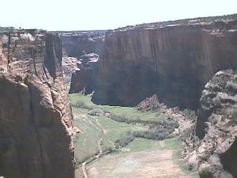
This photo is Canyon De Chelly National Monument. The Chinle Agency is the most
mountainous area of Navajoland. Unlike other areas of Navajoland, the
east-central area of the reservation is not desert-like or has dry creeks,
instead it has towering green mountains, thick forests, and green rolling hills
and running streams. Lukachukai Mountain and Chuska Mountain lie in this area
and play an important part of Navajo history. These two mountains were used to
hide the Navajos in 1864 when Kit Carson attacked the Navajos. Canyon De Chelly
National Monument and Wheatfields Lake are the only visited areas on this part
of Navajoland, Beautiful Valley is also located in this area just 15 miles south of Chinle heading towards Ganado. The scenic Buffalo Pass is located in this area as well, recently the road was paved from Lukachukai to Red Valley. This area of Navajoland shares its border with the Hopi Tribe. There are a few Navajo chapters that lie in the area of the Navajo-Hopi Land Dispute. Big Mountain is also located in this area as well. Central Navajoland is the smallest agency on the reservation.
CHINLE AGENCY
1,881,648,54 Acres
Agency Headquarters: Chinle
14 Chapters
Monuments And Parks And Attractions:
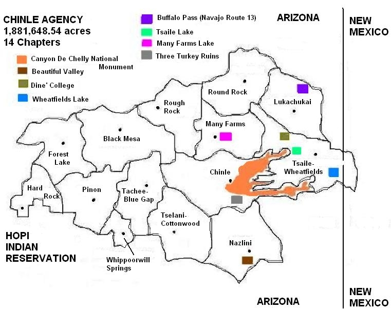
Chapter - Estimated Land Size - Date Certified
Black Mesa - 157,319.70 acres - April 27, 1979
Kits'illi': Ancient Ruins (Anasazi)
P.O. Box 189
Pinon, AZ 86510
Phone: (928) 309-7056
Fax: None
Distance to Chinle Agency: 65 miles
Distance to Window Rock: 119 miles
Chinle - 114,655.60 acres - February 14, 1956
Ch'inili: Flowing out to stream from mouth of canyon
P.O. Box 1809
Chinle, AZ 86503
Phone: (928) 674-2052
Fax: (928) 674-2079
Distance to Chinle Agency: 0 miles
Distance to Window Rock: 76 miles, 68 miles (Via Ganado)
Forest Lake - 125,169.80 acres - June 22, 1956
Tsiyi Be'ak'id: Lake in the woods
P.O. Box 441
Pinon, AZ 86510
Phone: (928) 677-3252/3347
Fax: (928) 677-3320
Distance to Chinle Agency: 53 miles
Distance to Window Rock: 108 miles
Hard Rock - 78,092.28 acres - December 5, 1955
Tse Dildo'i: Hard rocks
P.O. Box 20
Kykotsmovi, AZ 86039
Phone: (505) 725-3730/3727
Fax: (928) 725-3731
Distance to Chinle Agency: 63 miles
Distance to Window Rock: 115 miles
Lukachukai - 97,080.41 acres - November 14, 1955
Lok'aa'ch'egai: Reed streaking out white
P.O. Box 248
Lukachukai, AZ 86507
Phone: (928) 787-2332
Fax: (928) 787-2332
Distance to Chinle Agency: 34 miles
Distance to Window Rock: 61 miles
Many Farms - 168,006.20 acres - August 15, 1956
Da'ad'eh Halani: Many farms
P.O. Box 185
Many Farms, AZ 86538
Phone: (928) 781-3605/3610
Fax: (928) 781-3608
Distance to Chinle Agency: 14 miles
Distance to Window Rock: 82 miles (Via Ganado), 90 miles (Via Round Rock)
Nazlini - 216,520.07 acres - April 26, 1957
Nazlini: Bend (in the water) flow
P.O. Box 7387
Nazlini, AZ 86540
Phone: (928) 755-5900/5901
Fax: (928) 755-5903
Distance to Chinle Agency: 20 miles
Distance to Window Rock: 45 miles
Pinon - 107,250.40 acres - October 26, 1955
Be'ak'id Baa Ahoodzani: A body of water in sunken area
P.O. Box 127
Pinon, AZ 86510
Phone: (928) 725-3710
Fax: (928) 725-3712
Distance to Chinle Agency: 43 miles
Distance to Window Rock: 97 miles
Round Rock - 201,188.60 acres - February 14, 1956
Tse Nikani: Flat plated rock (or mesa)
P.O. Box 10
Round Rock, AZ 86547
Phone: (928) 787-2510
Fax: (928) 787-2512
Distance to Chinle Agency: 30 miles
Distance to Window Rock: 74 miles
Rough Rock - 52,679.95 acres - February 5, 1968
Tse Ch'izhi: Rough rock
P.O. Box IHH-RRTP
Chinle, AZ 86503
Phone: (928) 728-3361
Fax: (928) 728-3362
Distance to Chinle Agency: 30 miles
Distance to Window Rock: 98 miles (Via Ganado), 106 miles (Via Round Rock)
Ta Chee/Blue Gap - 116,102.70 acres - February 14, 1956
Bis Dootl'izh Nideeshgiizh: Blue clay gap
P.O. Box 4427
Blue Gap, AZ 86520
Phone: (928) 309-7276 (cellular)
Fax: (928) 674-2253
Distance to Chinle Agency: 35 miles
Distance to Window Rock: 89 miles
Wheatfields/Tsaile/Black Rock - 162,494.04 acres - December 2, 1955
To Dzis'a: Many ponds / Tsehili': Flowing through rock crevice/ Tse' zhini:
Black rock
P.O. Box 667
Tsaile, AZ 86556
Phone: (928) 724-3326
Fax: (928) 724-3388
Distance to Chinle Agency: 33 miles
Distance to Window Rock: 43 miles
Tselani/Cottonwood/Black Mountain - 252,518.80 acres - March 7, 1958
Tse' Lani: Many rocks
No address or phone given
Distance to Chinle Agency: 23 miles
Distance to Window Rock: 77 miles
Whippoorwill Spring - 32,605.00 acres - August 27, 1979
Hooshdodii To: Whippoorwill springs
P.O. Box 279
Pinon, AZ 86510
Phone: (928) 725-3727/3728
Fax: (928) 725-3745
Distance to Chinle Agency: 31 miles
Distance to Window Rock: 88 miles
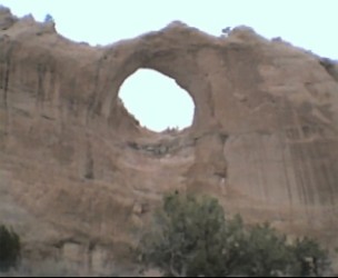
This photo is Window Rock. This part of the region lies in the state of New Mexico and Arizona. This area of Navajoland is mainly desert with a few mountains. Hubbell Trading Post National Historic Site, Kinlichee Ruins Navajo Tribal Park, Bowl Canyon Recreation Area, Navajo Nation Tribal Zoo and Petrified Forest National Park are the areas tourist attractions. This area also shares its border with the Hopi Tribe. The community of Jeddito is surrounded by the Hopi Reservation and in turn, the Hopi Reservation is surrounded by the Navajo Reservation. The tribal capital of the Navajo Nation is located here; Window Rock, Arizona. It is located seven miles south of the agency headquarters of Fort Defiance. The New Lands or Nahata Dzil is located here, it was the last chapter to be certified in 1991, given as replacement land for the relocated Navajos who were affected by the Navajo-Hopi Land Dispute. The Fort Defiance agency is the third largest agency on the reservation.
FORT DEFIANCE AGENCY
3,178,931.16 Acres
Agency Headquarters: Fort Defiance
27 Chapters
Monuments And Parks And Attractions:
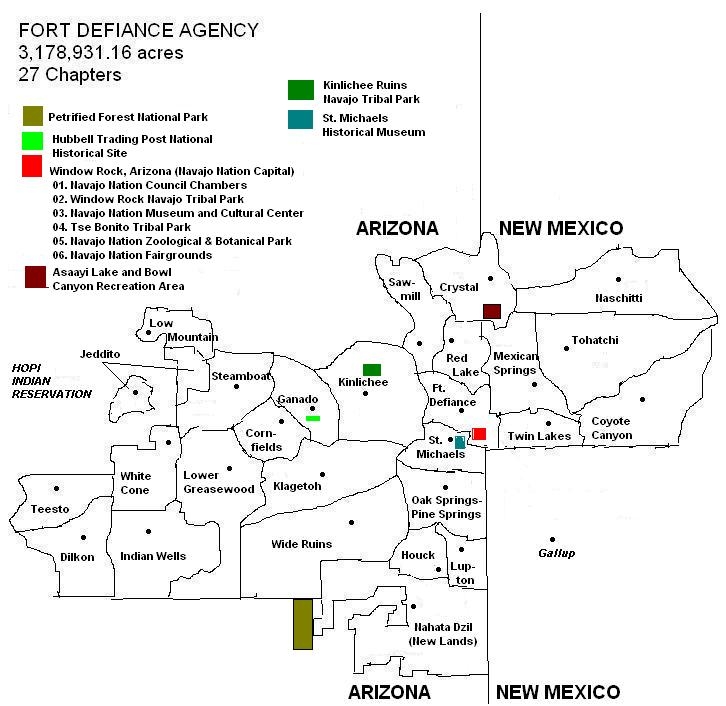
Chapter - Estimated Land Size - Date Certified
Cornfields - 44,004.97 acres - October 26, 1955
K'iiltsooitah: Among the rabbit brush
P.O. Box 478
Ganado, AZ 86505
Phone: (928) 755-5911/5912
Fax: (928) 755-5917
Distance to Fort Defiance Agency: 52 miles
Distance to Window Rock: 46 miles
Coyote Canyon - 125,996.01 acres - November 10, 1955
Ma'ii Teeh Yitlizhi: Coyote fell in the water(ing hole)
P.O. Box 257
Brimhall, NM 87310
Phone: (505) 735-2204/2205
Fax: (505) 735-2207
Distance to Fort Defiance Agency: 39 miles
Distance to Window Rock: 33 miles
Crystal - 90,719.86 acres - November 10, 1955
To Nilts'ili: Crystal clear water
P.O. Box 775
Navajo, NM 87328
Phone: (505) 777-2801
Fax: (505) 777-2805
Distance to Fort Defiance Agency: 25 miles
Distance to Window Rock: 30 miles
Dilkon - 244,283.40 acres - January 8, 1957
To Al Chi'di: Small amount of water
HC-63, Box E
Winslow, AZ 86047
Phone: (928) 657-3376
Fax: (928) 657-3324
Distance to Fort Defiance Agency: 96 miles
Distance to Window Rock: 90 miles
Fort Defiance - 102,154.20 acres - November 14, 1955
Tse Hootsooi: Yellowish columns of rock
P.O. Box 366
Ft. Defiance, AZ 86504
Phone: (928) 729-4352
Fax: (928) 729-4353
Distance to Fort Defiance Agency: 0 miles
Distance to Window Rock: 5 miles
Ganado - 91,535.75 acres - December 5, 1955
Lok'aah Niteel: Wide patch of reed
P.O. Box 188
Ganado, AZ 86505
Phone: (928) 755-5920
Fax: (928) 755-5927
Distance to Fort Defiance Agency: 38 miles
Distance to Window Rock: 31 miles
Houck - 84,687.39 acres - March 20, 1956
Ma'ii To'i: Coyote springs
P.O. Box 127
Houck, AZ 86506
Phone: (928) 688-2734
Fax: (928) 688-3068
Distance to Fort Defiance Agency: 41 miles
Distance to Window Rock: 36 miles
Indian Wells - 227.499.80 acres - August 15, 1956
To Hahadleeh: Dipping water from well
P.O. Box 3049
Indian Wells, AZ 86031
Phone: (928) 654-3289
Fax: (928) 654-3282
Distance to Fort Defiance Agency: 82 miles
Distance to Window Rock: 76 miles
Jeddito - 100,342.58 acres - November 8, 1955
Jadi To: Antelope water
P.O. Box 798
Keams Canyon, AZ 86034
Phone: (928) 738-2276
Fax: (928) 738-5455
Distance to Fort Defiance Agency: 72 miles
Distance to Window Rock: 66 miles
Kinlichee - 234,341.80 acres - April 13, 1956
Kin Dah Lichi'i: Red house (Anasazi ruins of red sandstone in the area)
No address or phone given
Distance to Fort Defiance Agency: 33 miles
Distance to Window Rock: 28 miles
Klagetoh - 151,977.80 acres - October 26, 1955
Leeyi' To: Water underneath (the ground)
P.O. Box 1019
Ganado, AZ 86505
Phone: (928) 652-2700
Fax: (928) 652-2701
Distance to Fort Defiance Agency: 50 miles
Distance to Window Rock: 45 miles
Low Mountain - 41,382.15 acres - May 9, 1967
Jeed Deez'a: (Pitch) gum extending out
P.O. Box 798
Keams Canyon, AZ 86034
Phone: (928) 738-2276
Fax: (928) 738-5455
Distance to Fort Defiance Agency: 113 miles
Distance to Window Rock: 107 miles
Lower Greasewood - 314,006.40 acres - December 5, 1955
Ayaai Diwozhii Bii' To: Lower greasewood springs
No address or phone given
Distance to Fort Defiance Agency: 63 miles
Distance to Window Rock: 58 miles
Lupton - 80,139.30 acres - March 7, 1958
Tse Si'ani: Rock in-place
P.O. Box 403
Lupton, AZ 86508
Phone: (928) 688-2128
Fax: (928) 688-3150
Distance to Fort Defiance Agency: 32 miles
Distance to Window Rock: 27 miles
Mexican Springs - 115,117.05 acres - December 5, 1955
Naakaii Bito'i: Mexicans' water
P.O. Box 93
Mexican Springs, NM 87320
Phone: (505) 733-2832
Fax: (505) 733-2833
Distance to Fort Defiance Agency: 39 miles
Distance to Window Rock: 33 miles
Nahata Dziil(Also called the New Lands) - 351,691 acres - April 4, 1991
Nahatah' dzil: Planning with strength; strong planning
No address or phone given
Distance to Fort Defiance Agency: 51 miles
Distance to Window Rock: 46 miles
The New Lands was established in 1986, the last of reservation lands to be added to Navajoland. This was given to the Navajo Nation in replacement for the 1974 Navajo-Hopi Land Settlement which divided the disputing land between the Navajo and Hopi Tribes. Development of this community is ongoing and includes areas designated for various uses, including: residential, industrial, commercial, community and educational facilities; as well as agriculture and recreational uses. The chapter of Nahata Dzil was established on April 4, 1991, the last of the 110 chapters to make up the boundaries of the Navajo Reservation.
Naschitti - 188,213.60 acres - February 15, 1956
Nashashch'idi: Badger
P.O. Box Drawer D
Sheepsprings, NM 87364
Phone: (505) 732-5400/5402
Fax: (505) 732-5406
Distance to Fort Defiance Agency: 59 miles
Distance to Window Rock: 53 miles
Oak Springs/Pine Springs - 77,426.47 acres - March 20, 1956
T'eel Chi'init'i' / T'iis li'ahi: Marsh cattail coming out in a row
P.O. Box 486
Window Rock, AZ 86515
Phone: (928) 871-6182/6179
Fax: (928) 871-6182
Distance to Fort Defiance Agency: 22 miles
Distance to Window Rock: 17 miles
Red Lake (Navajo, N.M.) - 43,989.29 acres - March 7, 1958
Be'ak'id Halchii': Red lake
No address or phone given
Distance to Fort Defiance Agency: 14 miles
Distance to Window Rock: 19 miles
Sawmill - 77,423.80 acres - January 8, 1957
Ni'iijiih Hasani: Old sawmill
P.O. Box 1786
Ft. Defiance, AZ 86504
Phone: (928) 729-4433
Fax: (928) 729-4435
Distance to Fort Defiance Agency: 13 miles
Distance to Window Rock: 18 miles
St. Michaels - 75,553.11 acres - February 16, 1956
Ch'iootso: Green meadow spreading out from narrow point
P.O. Box 829
St. Michaels, AZ 86511
Phone: (928) 871-7842/7844
Fax: (928) 871-3023
Distance to Fort Defiance Agency: 6 miles
Distance to Window Rock: 2 miles
Steamboat - 200,799.80 acres - December 5, 1955
Hoyee: Fear
P.O. Box 117
Ganado, AZ 86505
Phone: (928) 736-2631/2633
Fax: (928) 736-2634
Distance to Fort Defiance Agency: 56 miles
Distance to Window Rock: 51 miles
Teesto - 98,145.25 acres - November 10, 1955
T'iis To: Road across (the wash)
P.O. Box 7166
Winslow, AZ 86047
Phone: (928) 657-8042
Fax: (928) 657-8046
Distance to Fort Defiance Agency: 104 miles
Distance to Window Rock: 98 miles
Tohatchi - 131,247.40 acres - December 5, 1955
To Haach'i': Water see page (scratching for water)
P.O. Box 1236
Tohatchi, NM 87325
Phone: (505) 733-2660
Fax: (505) 733-2321
Distance to Fort Defiance Agency: 39 miles
Distance to Window Rock: 34 miles
Twin Lakes - 69,134.45 acres - February 14, 1956
Tse Nahadzoh: Earth marked my rocks
P.O. Box 4424
Yah-Ta-Hey, NM 87375
Phone: (505) 735-2600/2601
Fax: (505) 735-2605
Distance to Fort Defiance Agency: 28 miles
Distance to Window Rock: 23 miles
Whitecone - 19,637.05 acres - April 26, 1957
Be'ak'id Baa'a'oogeed: Excavated for a pond
P.O. Box 3338
Indian Wells, AZ 86031
Phone: (928) 654-3319
Fax: (928) 654-3319
Distance to Fort Defiance Agency: 82 miles
Distance to Window Rock: 76 miles
Wide Ruins - 149,171.70 acres - February 15, 1956
Kin Niteel:: Wide building
P.O. Box 208
Chambers, AZ 208
Phone: (928) 652-3223
Fax: (928) 652-3253
Distance to Fort Defiance Agency: 58 miles
Distance to Window Rock: 53 miles
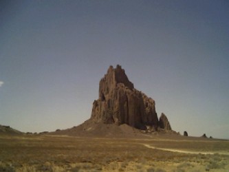
This photo is Shiprock Pinnacle. The Shiprock Agency as with other part of Dinetah are filled with canyons, desert and is located nearby the Chuska Mountains. The Carrizo Mountain is also located in the region. Four Corners Monument and the Shiprock Pinnacle are the only tourist attractions. But Red Valley, Rock Point and Cove chapters are scenic and is a well worth drive through the area. Shiprock Agency is also proud to have the community of Two Grey Hills as part of their agency, for this community is well known for it's beautiful rug weaving known worldwide. The community of Shiprock holds the annual Northern Navajo Nation Fair and the Yei Bi Cheii Ceremony is held during this time as well. It is the oldest of the Navajo fairs. This side of Navajoland shares its border with the Ute Mountain Ute Tribe of Towaoc, Colorado. Northern Navajoland is the fourth largest agency on the reservation.
SHIPROCK AGENCY
2,726,437.85 Acres
Agency Headquarters: Shiprock
20 Chapters
Monuments And Parks And Attractions:
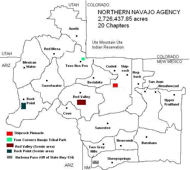
Chapter - Estimated Land Size - Date Certified
Aneth - 183,779.08 acres - February 16, 1956
T'aa Biich' iidii: Just like the devil
P.O. Box 430
Montezuma Creek, UT 85434
Phone: (435) 651-3494
Fax: (435) 651-3413
Distance to Shiprock Agency: 56 miles
Distance to Window Rock: 152 miles
This is the northern most chapter of the Navajo Nation. It is located on the
Utah side of the reservation off of State Highway 262. Aneth is situated next to
the San Juan River, which obviously the community used to survive in the area.
Just 3-5 miles north is another community, Montezuma Creek. There is a clinic
and a high school there. Bluff, Utah is 15 miles away, located off of the
reservation. The community of Aneth is very scenic as red bluffs and mesas
dominate the area. There is however an eyesore; a maze of gas pipes run through
the area. The chapter of Aneth shares it's border with the Ute Mountain Ute
Tribe of Colorado.
Beclabito - 86,520.63 acres - December 5, 1968
Bitl' aa Bito: Water beneath
Beclabito Express
Shiprock, NM 87420
Phone: (928) 656-3265
Fax: (928) 656-3813
Distance to Shiprock Agency: 18 miles
Distance to Window Rock: 107 miles
At the northeastern end of the state of New Mexico is the chapter of Beclabito.
Carrizo Mountain can be seen in the background. In this community, the landmarks
surrounding the Four Corners can be seen such as Carrizo Mountain, Sleeping Ute
Mountain in Colorado, the Shiprock Pinnacle, the Hogbacks near Morgan Lake, the
Chuska and Lukachukai Mountains can be seen.
Burnham - 185,807 acres - February 15, 1956
T'iistsoh Sikaad: Spreading of large cottonwood
P.O. Box 7359
Newcomb, NM 87455
Phone: (505) 696-3323
Fax: (505) 696-3323
Distance to Shiprock Agency: 20 miles
Distance to Window Rock: 68 miles
The community of Burnham is the perfect example of a 'reservation community'. It
is located out in the middle of nowhere on Navajo Route 5. Its residence are
scattered throughout the 185,807 acre chapter landbase. There is no water in the
area so the community transports its own water from other areas. North of the
chapter, the Hogbacks stand high in the area. Ford Butte and Bennett Peak are
also seen in the distance.
Cove - 44,353.10 acres - August 27, 1981
K'aabihi Nas La: Cactus plant
No address or phone given
Distance to Shiprock Agency: 42 miles
Distance to Window Rock: 117 miles
Cove is one of the few new communities on the Navajo Nation. It was certified as
a chapter in 1981. It was before part of the Red Valley landbase. The community
is located in the eastern slopes of the Lukachukai and southeastern slopes of
the Carrizo Mountains. Like Red Valley, Cove is very scenic as there is a
natural arch near Kahbihghi Valley.
Cudeii - 102,736.80 acres - May 19, 1978
Gad li'ai: One juniper standing
P.O. Box 1318
Shiprock, NM 87420
Phone: (505) 368-1071
Fax: (505) 368-1072
Distance to Shiprock Agency: 10 miles
Distance to Window Rock: 114 miles (Via Yatahey)
Once part of the Shiprock chapter, in May 19, 1978 it ceded to form its own
chapter. According to the Tribe's Office of Navajo Land Administration, there
are no official boundry for Cudeii. Tribal leader, Sam Ahkeah was from the
Cudeii area. Mr. Ahkeah was the 7th chairman of the Navajo Tribal Council, he
served from 1946 to 1954. Gas and oil were discovered in the area, in order for
the tribe to make contracts with an oil company, the BIA asked for the Cudeii
area to have a spokesman, which lead to the first Navajo Tribal Council. The
first Navajo settlers began using this land after returning from the Long Walk,
they used the San Juan River to develop farms. At one time, one juniper tree was
growing near the river bank. It no longer stands, but that is how Cudeii got
it's name.
Upper Fruitland - 83,368.70 acres - November 10, 1955
Doo' Alk'aii: No fat (valley)
P.O. Box 1257
Fruitland, NM 87416
Phone: (505) 598-5032
Fax: (505) 598-0614
Distance to Shiprock Agency: 28 miles
Distance to Window Rock: 116 miles (Via Shiprock and Crystal)
Hogback - 60,362.90 acres - April 27, 1978
Tse'daak'a: Rock grounded into water
P.O. Box 1288
Shiprock, NM 87420
Phone: (505) 368-5500
Fax: (505) 368-4812
Distance to Shiprock Agency: 5 miles
Distance to Window Rock: 107 miles (Via Yatahey)
Mexican Water - 160,241.60 acres - August 15, 1956
Naakaii To: Mexican's water(ing point)
Red Mesa TP #1019, HC 61 Box 38
Teec Nos Pos, AZ 86514
Phone: (928) 674-3641
Fax: None
Distance to Shiprock Agency: 62 miles
Distance to Window Rock: 111 miles
Community members tell of 3 Mexicans, while traveling across the area, dug wells
and used as a watering place. Navajos met in front of a trading post for their
meetings until their chapter house was built. Much of the area is rocky and
makes it difficult for power lines, water lines, or any other construction. So
today, a large majority of the community lacks electricity and/or water. The
area is very scenic as red rocks and bluffs surround the area.
Nenahnezad - 117,242.30 acres - November 10, 1955
Niinahnizaad: Long incline of hill
P.O. Box 438
Fruitland, NM 87416
Phone: (505) 598-9702
Fax: (505) 598-9702
Distance to Shiprock Agency: 24 miles
Distance to Window Rock: 111 miles (Via Shiprock and Crystal)
Newcomb - 56,635.11 acres - October 21, 1981
T'iis Nideeshgiizh: Cottonwood grove spreading from wash
P.O. Box 7982
Newcomb, NM 87455
Phone: (505) 696-3436
Fax: (505) 696-3436
Distance to Shiprock Agency: 34 miles
Distance to Window Rock: 53 miles (Via Crystal)
Red Mesa - 267,371.40 acres - August 1, 1967
Lichii' Dah Azkani: Reddish mesa
P.O. Box 422
Montezuma Creek, UT 84534
Phone: (928) 656-3655/3656
Fax: (928) 656-3658
Distance to Shiprock Agency: 42 miles
Distance to Window Rock: 121 miles
Red Mesa is one of the four chapters located on the Utah side of the
reservation. Aneth, Navajo Mountain and Oljeto are the other three. Before 1967,
the area was part of the Mexican Water Chapter. But long distances and
unpassable roads to Mexican Water called the local community to request a
separate chapter. 267,371.40 acres was certified as the Red Mesa Chapter on
August 1, 1967. The chapter house is located next to a large red mesa, thus the
chapter name; Red Mesa.
Red Valley - 221,347.80 acres - April 13, 1956
Tse Lichii' Dah Azkani: Red rock mesa
P.O. Box 304
Red Valley, AZ 86544
Phone: (928) 653-5800
Fax: (928) 653-5803
Distance to Shiprock Agency: 28 miles
Distance to Window Rock: 103 miles (Via Crystal)
Rock Point - 138,758.30 acres - March 7, 1958
Tse Nitsaa Deez'ahi: Large rock protruding
P.O. Box 190
Rock Point, AZ 86545
Phone: (928) 659-4350
Fax: (928) 659-4356
Distance to Shiprock Agency: 72 miles
Distance to Window Rock: 91 miles
Rock Point is one of the most beautiful chapters of the Navajo Nation. Just a
cruise through the area is a worth while trip. In the early days, Navajos called
the community Beesh' ii ahi, which translates to 'standing metal', referring to
a windmill in the area. It was later changed to Tse Nitsaa Deez' ahi, meaning
'large rock protruding'. In referrence to a rock formation in the area.
Sanostee - 313,576.40 acres - November 10, 1955
Tse Alnaozt'i'i: Crisscrossing rock
P.O. Box 219
Sanostee, NM 87461
Phone: (505) 723-2702
Fax: (505) 723-2705
Distance to Shiprock Agency: 30 miles
Distance to Window Rock: 73 miles
San Juan - No Official Boundary - December 29, 1982
Tse'daak'aan: Rock grounded into water
P.O. Box 1636
Fruitland, NM 87416
Phone: (505) 598-6916
Fax: (505) 598-0021
Distance to Shiprock Agency: 10 miles
Distance to Window Rock: 99 miles
San Juan Chapter was first certified in the
1970's, then was later decertified and on December 29, 1982 it was certified
again as a chapter, creating problems of project delays for the chapter, thus no
boundary line is drawn.
Sheepsprings - 108,563.90 acres - December 2, 1955
Debe Bito Litsooi: Yellowish water
P.O. Box Drawer I
Sheepsprings, NM 87364
Phone: (505) 732-5408
Fax: (505) 732-4244
Distance to Shiprock Agency: 45 miles
Distance to Window Rock: 43 miles (Via Crystal)
Shiprock - 125,314.20 acres - October 26, 1955
Natanni Nez: Tall Man
P.O. Box 3810
Shiprock, NM 87420
Phone: (505) 368-1081
Fax: (505) 368-1092
Distance to Shiprock Agency: 0 miles
Distance to Window Rock: 89 miles (Via Crystal), 103 miles (Via Yatahey)
Sweetwater - 152,066.30 acres - February 14, 1956
To Likan: Sweet water
P.O. Box 105
Teec Nos Pos, AZ 86514
Phone: (505) 368-1020 (Message)
Fax: None
Distance to Shiprock Agency: 52 miles
Distance to Window Rock: 117 miles
Located off of Navajo Route 35, which is 14 miles off of the paved road of U.S.
Highway 160. Though only 14 miles, it took me 45 minutes to reach the To' Likan
chapter house. The road is unpassable and makes me wonder how the residence make it day by day on these roads. While the dirt road is unpassable, the views of
the Sweetwater chapter are beautiful, the Carrizo Mountain adds to the scenery
as too the Lukachukai Mountains standing in the distance. Red mesas and red sand
cover the area. There are also houses (Yes! Navajos live out here!) The unstable
road takes you to the back country of Navajoland and ends at the chapter of Rock
Point. The photo shots are limitless in this area!
Teec Nos Pos - 233,433 acres - November 10, 1955
T'iis Nasbas: Round tree
P.O. Box 106
Teec Nos Pos, AZ 86514
Phone: (928) 656-3662
Fax: (928) 656-3661
Distance to Shiprock Agency: 29 miles
Distance to Window Rock: 117 miles
Every community on the Navajo Nation I find unique. A perfect example is that of
the chapter of Teec Nos Pos. It is the only community on the reservation where
its landbase extends into all three states (Arizona, New Mexico and Utah). The
community is located at the base of the Carrizo Mountain. Four Corners Navajo
Tribal Park is located here, sharing one of the states (Colorado) with the Ute
Mountain Ute Tribe, where their reservation is located at. The name Tiis Nazbas,
was given to the area in the 1880's after a cottonwood tree which had a trunk
that formed a circle. The tree no longer exists.
Two Grey Hills - 84,930.91 acres - December 2, 1955
Bis Dah Litso: Yellow clay mounds
P.O. Box 7894
Newcomb, NM 87455
Phone: (505) 789-3100
Fax: (505) 789-3101
Distance to Shiprock Agency: 42 miles
Distance to Window Rock: 67 miles (Via Crystal)
Hundreds of well-wishers lined the muddy streets on Saturday, March 3, 2001 to celebrate former Navajo Chairman Peter MacDonald's release from prison, and this time they got to see and hear the man they came to welcome home. "Not many people know what it's like behind that wall," MacDonald told about 200 supporters who jammed the small Tonanees' dizi Chapter House and 200 more who listened outside on a speaker system or pressed their faces to windows and open doors. "I was fortunate to come back from that place alive. I would not wish that on even my worst enemy what's behind that wall."
MacDonald, 72, led America's largest Indian tribe off and on throughout the 1970s and 80s. The Navajo Tribal Council removed him from office amid a corruption scandal in 1989, and months later a group of his supporters stormed the tribal headquarters in Window Rock, Arizona in an attempt to restore him to power. A riot had started and tribal police opened fire, and two MacDonald supporters died. A riot that has divided the Navajo Nation. MacDonald was convicted on federal conspiracy charges for inciting the riot and for taking bribes and kickbacks. He has maintained his innocence and resisted making a public apology.
The Navajo Tribal Council pardoned MacDonald in 1995. Former United States President Bill Clinton commuted MacDonald's sentence on January 20, 2001, freeing him from the Federal Medical Center in Fort Worth, Texas. He had served over half his 14-years sentence.
Supporters gathered for a homecoming celebration in Farmington, New Mexico, but MacDonald was unable to attend due to his poor health. He had a heart attack in the mid-1990s and underwent quadruple bypass surgery in 1999. MacDonald can walk short distances with a cane and uses a wheelchair for longer periods. He also suffers from arthritis, high blood pressure and back problems. Saturday's gathering in the small reservation town of Tuba City, a community 80 miles north of Flagstaff where MacDonald now lives, started with a parade. A smiling MacDonald rode in the back of a pickup truck with his wife, Wanda, waving throughout the two-mile route. After the parade, the crowd squeezed into the chapter house and crowded outside to listen while presenters, including Navajo Vice President Dr. Taylor MacKenzie, cheered MacDonald's return.
"It's such a great feeling. It's like there's a great weight lifted off your chest," James Bilagody, a Navajo Councilman from Tuba City said. "He's home. I've dreamt of this moment for so many years." Much of the presentation and discussion was in Navajo, interspersed with bits of English. MacDonals shared stories about waiting for word on his release and how he walked out of prison wearing a pair of Levi's size 36 waist, 40 inseam. The jeans were so big he had to cinch up the waist and roll huge cuffs on the legs to wear them. His first stop outside the prison was McDonald's. "I had a Big Mac with french fries and a real Coke," MacDonald said. MacDonald spent much of his time thanking people for their letters, prayers and support. "It's good to be home. It's good to be with my wife, my children, my friends," he said. "I can't thank you enough for all you have done to help me regain my freedom."
MacDonald also encouraged Navajos to pull together now that his prison sentence is over. "Working together, respecting each other's dignity, that's what we need to get to an ever higher level than we were before," he said. While MacDonald's troubles have been a source of great division within the tribe, no protesters showed up during Saturday's event. Vern Lee of Farmington, New Mexico, who was active in pushing for MacDonald's release, said he hopes the people of the Great Navajo Nation can reconcile those differences with forgiveness and compassion. "I tell them, reach out to those who are still angry and hurt," Lee said. "That's the Navajo way. Do your part. We haven't done that for many years."
 The tribal seal which was designed by John Claw Jr. of Many Farms, Arizona and
adopted on January 18, 1952. The great seal bears a ring of 48 arrow heads
representing the then 48 states of the United States and reflects on Navajo
Nation protected by the United States. Within this ring of arrowheads are three
concentric circles that are not completed at the top. These circles represent
the rainbow, open to the east,, and symbolize the Navajo Nation itself. It is a
reminder that the sovereignty of the Navajo Nation is never closed. The ring are
turquiose outermost, then yellow and lastly red. Within these rings are two corn
plants, the sustainer of life for the Navajo, their tips yellow showing pollen,
a substance used frequently in Navajo ceremonies. Within the corn are four
differently colored mountains and a horse, cow and sheep representing livestock,
a main source of wealth for the Navajo. The four sacred mountains are shown in
turquoise, white, black and yellow. The four color mountains are the recurring
theme in the stories and legends of the Navajo.
The tribal seal which was designed by John Claw Jr. of Many Farms, Arizona and
adopted on January 18, 1952. The great seal bears a ring of 48 arrow heads
representing the then 48 states of the United States and reflects on Navajo
Nation protected by the United States. Within this ring of arrowheads are three
concentric circles that are not completed at the top. These circles represent
the rainbow, open to the east,, and symbolize the Navajo Nation itself. It is a
reminder that the sovereignty of the Navajo Nation is never closed. The ring are
turquiose outermost, then yellow and lastly red. Within these rings are two corn
plants, the sustainer of life for the Navajo, their tips yellow showing pollen,
a substance used frequently in Navajo ceremonies. Within the corn are four
differently colored mountains and a horse, cow and sheep representing livestock,
a main source of wealth for the Navajo. The four sacred mountains are shown in
turquoise, white, black and yellow. The four color mountains are the recurring
theme in the stories and legends of the Navajo.
Flying over the vast Dinehtah is the flag of the Navajo Nation. The flag,
adopted on May 21, 1968 by the Tribal Council in Window Rock, Arizona, was
designed by Jay R. DeGroat, a Navajo from Mariano Lake, New Mexico, now living
in Arizona and won out over 140 other suggested designs. The flag is a pale buff
color bearing a map of the Navajo Indian Reservation in two colors. The original
boundaries of the 1868 reservation are shown in dark brown, while the much
larger current borders are shown in a copper color. Surrounding the map are the
four sacred mountains and over the top of all this is the rainbow motif
mentioned in the great seal. Centered on the map is a white disc bearing the
corn stalks and domestic animals form the seal. In addition to these there are
representations of other aspects of the Navajo's economy; a traditional hogan,
oil drilling equipment, forestry, mining and recreational fishing and hunting.
The green and yellow corn stalks appear in black outline. In 1995, the flag of
the Navajo Nation became the first Native American tribal flag to fly into space
when it was carried aboard the space shuttle Discovery by astronaut Bernard
Harris. Dr. Harris is an African-American physician who lived on the Navajo
Reservation when he was a child. Dr. Harris had asked the Navajo for some token
to take into space with him and then President Albert Hale of the Navajo Nation
decided upon the flag. Before it was flown, however, the flag was blessed by a
medicine man of the Navajo by sprinkling corn pollen upon it. The shaman also
had to be assured that the Discovery's flight path conformed to Navajo religious
beliefs in that the spacecraft had to fly in a clockwise direction. After its
February flight the flag was flown over the Navajo National Capitol in Window
Rock, Arizona.
Late March 2001, 12 members of the Navajo government charted a plane and flew to Billings, Montana to meet with tribal representatives from Montana and Wyoming. After four days of meetings, the tribal leaders from 10 tribes fashioned a charter for the new organization called The Council Of Large Land Based Tribes. According to the charter, a tribe must have a least 100,000 acres to join the council. The Navajo have a land base of 17.5 million acres. The tribes in Montana and Wyoming have a total land base of 10.4 million acres. Edward T. Begay, Speaker of the Navajo Nation Council, inititated the organization with a meeting in Window Rock. He said there was a great need for large land based tribes to organize. Many Indian organizations, he said, set priorities that benefit smaller tribes, such as Bridgeport Indian Colony of California that has a total of 37 tribal members and 40 acres of land. As a result, he said, the Navajo and other large land based tribes "have often been overlooked in the formation of national Indian Policy," Ervin Keeswood, a delegate from Hogback Chapter and the chairman of the Intergovernmental Relations Subcommittee for the council, agreed. "The Navajo Nation does a good job in bringing issues to the forefront," he said of the tribes constant lobbying effort in Washington. The problem is, he said, many other tribes are pursuing similar issues and its hard to get Congress to favor one tribe over another." Currently, the most popular tribal organization is the National Congress of American Indians, which represents 228 of the nations 552 recognized Indian Tribes. Indian leaders who attended the meeting in Window Rock last fall clearly felt the organization was not doing the larger tribes much good. According to its charter, the new council will support and uphold the sovereignty of the member tribes; foster the government-to-government relationship between the member tribes and the U.S. government; develop council position on issues impacting member tribes when concensus can be reached and, provide for coordination of lobbying efforts by council member tribes with federal, state, and local governments. The Indian leaders decided to establish a one year interim term for officers for the new operation which will include a president, vice-president, secretary and treasurer. During the 1st year, officers selected by various tribes will put together the by-laws of the organization. Those by-laws determine how tribes will used their allotted votes, wheather by delegates or block voting. During the first year, the president and treasurer will come from the Rocky Mountain region (Montana and Wyoming), while the vice-president and secretary will come from the Navajo Nation of Arizona, New Mexico and Utah. It was decided at the meeting in Billings that the officers would rotate from region to region. The tribes with membership of the council include the 1)Navajo, 2)Crow, 3)Northern Cheyenne, 4)Blackfeet, 5)Assiniboine Sioux, 6) Chippewa Cree, 7) Northern Cheyenne, 8) Salish Kootenai, 9) Eastern Shoshone, 10) Cheyenne River Sioux.
�...the Navajo Tribal Council resolve[s] that the Navajo Indian stand ready to aid and defend our Government and its institutions against all subversive and armed conflict...�
Resolution passed by the Navajo Tribal Council - June 3, 1940
In World War II, the United States was on the verge of losing the war since every code they used was broken by the Japanese. The enemy was one step ahead. Transmission of the standard USMC code might read: �XB6T7YJL9P2MDX4ZHP 6GWQ8U4RINL2T9VD5ABSWK6FB4YQLBR8DCZ8RDP6QLK9D� meaning: �Jump off at 0600; move 50 yards left flank of C Company; proceed 200 yards; and report to your position.� The USMC code could take up to four hours to decode. Pieces of the message were sometimes missing. After it was decoded, it was relayed to the commander. When an artillery strike was needed, it was needed promptly. This slow process caused major delays for critical battles.
Philip Johnson, a minister�s son was credited for conceiving the Navajo code. He lived on the reservation and knew the Navajo language was complex. In February, he turned this information over to the United States Marine Corps. Desperate, in September 1942, the United States Marine Corps. took the idea seriously since at the time the Navajo language was an unwritten language.
The actual creators of the Navajo Code Project were Major General Clayton B. Vogel, Amphibious Force, Pacific Fleet and Commandant Thomas Holcomb, USMC, headquartered at Camp Elliot, California.
With cooperation of four Navajos already living in the Los Angelas area, and another on active Naval service in San Diego. They simulated the idea. Translating the Navajo language during battle and transmitted it to another Navajo on the other side of the line. The second Navajo receiving the message then translated it to English in the same form which had been provided. The demonstration proved successful and as a result, General Vogel recruited at least 200 Navajos for the code talkers program.
Recruitment began on May 1942. Each Navajo underwent basic boot camp training at San Diego, the Marine Crops Recruit Dept before assignment to the Field Signal Battalion for training at Camp Pendleton.
A platoon of 30 Navajos was recruited in the spring of 1942. Its members were trained in signal work using the Navajo language as a code that the enemy was baffled by an Indian language used in front line communication. The thirty Navajo Marines performed their duties so successfully that the plan was expanded.
Beginning with the battle of Guadalcanal, then the Navajo Marines went island hopping on many Pacific Islands on their way to Japan. The Navajo Code Talkers fought in some of the fiercest battles of the Pacific war at: Bougainville, New Britain, Kwajalein, Saipan, Guam, Peleliu, Iwo Jima, Okinawa and many smaller islands in between.
The enemy never broke the code.
The entire Navajo Code Talkers Project was highly classified that the citizens of the United States did not know of this until it was declassified on June 25, 1969 at the Chicago 22nd reunion of the 4th Marine Division Association. They were later awarded a Certificate of Appreciation from the President of the United States in December 1981. But it wasn�t until July 26, 2001 the original 29 Navajo Code Talkers were awarded the Congressional Gold Medal of Honor at Capital Hill; a long overdue �thank you� from the United States....
The list below is names of those who received the award:
01. Charlie Y. Begay
02. Roy L. Begay
03. Samuel H. Begay
04. John Ashi Benally
05. Wilsie Bitsie
06. Cosey S. Brown
07. John Brown, Jr.
08. John Chee
09. Benjamin Cleveland
10. Eugene R. Crawford
11. David Curley
12. Lowell S. Damon
13. George H. Dennison
14. James Dixon
15. Carl N. Gorman
16. Oscar B. Ilthma
17. Allen Dale June
18. Alfred Leonard
19. Johnny R. Manuelito
20. William McCabe
21. Chester Nez
22. Jack Nez
23. Lloyd Oliver
24. Joe Palmer
25. Frank Danny Pete
26. Nelson S. Thompson
27. Harry Tsosie
28. John Willie
29. William Dean Wilson
 In the beginning, Native American chants and dances were thought to be of devil
concept. But in 1995, European music producer Claus Zundel released Sacred
Spirit - Chants And Dances Of The Native Americans. Taking traditional chants
from the Navajo, Pueblo, Sioux tribes and combined them with Western influenced
tracks. Released in Europe in 1995 the album became an instant best-seller. The
surprise hit album sold more than 7 million copies worldwide and several songs:
Tor-Cheney-Nahana (Winter Ceremony), Ly-O-Lay Ale Loya (Counterclockwise Circle
Dance), Dawa (The Cradlesong) did very well. But the international hit single,
Yeha-Noha (Wishes Of Happiness And Prosperity) topped the Europe music charts
and was 'up there' with world known music artists such as Madonna, R. Kelly and
Annie Lennox.
In the beginning, Native American chants and dances were thought to be of devil
concept. But in 1995, European music producer Claus Zundel released Sacred
Spirit - Chants And Dances Of The Native Americans. Taking traditional chants
from the Navajo, Pueblo, Sioux tribes and combined them with Western influenced
tracks. Released in Europe in 1995 the album became an instant best-seller. The
surprise hit album sold more than 7 million copies worldwide and several songs:
Tor-Cheney-Nahana (Winter Ceremony), Ly-O-Lay Ale Loya (Counterclockwise Circle
Dance), Dawa (The Cradlesong) did very well. But the international hit single,
Yeha-Noha (Wishes Of Happiness And Prosperity) topped the Europe music charts
and was 'up there' with world known music artists such as Madonna, R. Kelly and
Annie Lennox.
Only three tribes have participated in allowing traditional chants to be mixed with modern instrumentation and electronic drumbeats. Yeha-Noha, Tor-Cheney-Nahana, Lay-O-Lay Ale Loya, Celebrate Wild Rice are from the Navajo Nation. Dawa is from the Pueblo Nation while the chant for Heal The Soul is from the Sioux Nation. Throughout various parts of the album, the dialogue from 'Dances With Wolves' are heard.
A success on the Europe pop charts, Tor-Cheney-Nahana and Lay-O-Lay Ale Loya are featured on various compilation albums. Tor-Cheney-Nahana (Winter Ceremony) is featured on Ambient Moods: Chillout Tunes, Moods and Relaxations: Sound of the Ocean, Chillout Moods: Rain Dance, I Am Walking: New Native Music. Lay-O-Lay Ale Loya is featured on Native American Collection, Wolves: Original Sountrack Recording.
 The cd single to Yeha-Noha (Wishes Of Happiness And Prosperity) contains
several remixes such as: Yeha-Noha (Original Mix), Yeha-Noha (House Mix with
Drop), Yeha-Noha (Buffalo Bump Mix), Yeha-Noha (Pow Wow Mix), Yeha-Noha (Tribal
Totem Mix), Yeha-Noha (Peace Pipe Mix), Yeha-Noha (Mendelsohn Mix), Yeha-Noha
(Totem Grid Mix). The cd single to the beautiful Navajo chant was an instant
sell-out. The song to Yeha-Noha begins with a quiet introduction of drums and
strings and slowly increases until timpani's announces the melody of beautiful
cello and violin solos. After the gorgeous melody, a voice that seems to be
heard from centuries ago sing an ancient chant and cries out for hope and future
for his tribe. After each verse of the chant, his voice echoes as if determined
to be heard. A chant that has withstood the test of time; a voice so filled with
emotion that it moves the soul to 'happiness and prosperity'...
Click here to view lyrics to Yeha-Noha
The cd single to Yeha-Noha (Wishes Of Happiness And Prosperity) contains
several remixes such as: Yeha-Noha (Original Mix), Yeha-Noha (House Mix with
Drop), Yeha-Noha (Buffalo Bump Mix), Yeha-Noha (Pow Wow Mix), Yeha-Noha (Tribal
Totem Mix), Yeha-Noha (Peace Pipe Mix), Yeha-Noha (Mendelsohn Mix), Yeha-Noha
(Totem Grid Mix). The cd single to the beautiful Navajo chant was an instant
sell-out. The song to Yeha-Noha begins with a quiet introduction of drums and
strings and slowly increases until timpani's announces the melody of beautiful
cello and violin solos. After the gorgeous melody, a voice that seems to be
heard from centuries ago sing an ancient chant and cries out for hope and future
for his tribe. After each verse of the chant, his voice echoes as if determined
to be heard. A chant that has withstood the test of time; a voice so filled with
emotion that it moves the soul to 'happiness and prosperity'...
Click here to view lyrics to Yeha-Noha
Yeha-Noha was so loved by many that the hit single made it onto various compilation albums such as Blanco Y Negro Mix Vol. 2, Trip Around The World, Healing (A Trip To Infinity), Most Relaxing Album In The World... Ever, World Moods, Spirits of Nature, One World, Totally ChillOut (The Essential Chill-Out Album), Survival For Tribal Peoples, Mystic Moods II, Most Relaxing Feel, Magic Mysteries 2, Chillout Moods: Tubular Bells, the chart topping single also made it onto the highly praised Pure Moods album. Dawa (The Cradlesong) made it onto Pure Moods II. Yeha-Noha created a generation of ambient music and listeners wanted more...
 Sacred Spirit II - More Chants And Dances Of The Native Americans was released
in 2000. Again, traditional ceremonial chants were mixed with modern
instrumental arrangements and the single Dela Dela, earned its position on the
recently released Pure Moods III. Yane-Heja-Hee sounds similar to the main
single Yeha-Noha because the same chant source has been used as well as similar
backing instruments and arrangments.
Sacred Spirit II - More Chants And Dances Of The Native Americans was released
in 2000. Again, traditional ceremonial chants were mixed with modern
instrumental arrangements and the single Dela Dela, earned its position on the
recently released Pure Moods III. Yane-Heja-Hee sounds similar to the main
single Yeha-Noha because the same chant source has been used as well as similar
backing instruments and arrangments.
The single Yane-Heja-Hee has already been compiled onto 'All The Hits Now Inverno 2000' album, which also includes worldwide recognized artists such as Moby (Porcelain), Melanie C (I Turn To You [Hex Hector Remix]), ColdPlay (Yellow), Britney Spears (Lucky) and more, Sacred Spirit II was a nominee for the best New Age album for the 2001 Grammy's.
With the success of Yeha-Noha (Wishes Of Happiness And Prosperity), although many members of the Navajo Nation (mostly elderly) felt the chants used should have never been sold to Virgin Records, who took the chance to create a Native American album. Since the vocal chants to Yeha-Noha originated among the Navajo Nation, members felt the chants should be used ONLY for ceremonial purposes, not for mainstream musical entertainment. Tor-Cheney-Nahana (Winter Ceremony) was another chant that originated among the Navajos. Yane-Heja-Hee, from Sacred Spirit II, is another song taken from the tribe. Whether members agree or disagree, as mentioned, in the beginning Native American chants and dances were thought to be of devil concept, but with the success and help from both Sacred Spirit albums, listeners are finding Native American chants soothing and relaxing and will one day hopefully understand the ways of life of the Native Americans...
During the fall session of October 15 to 19, 2001, the Navajo Nation Council approved a gaming ordinance. In a move to jump-start the economy, the Navajo Nation is now officially a gaming tribe. The Navajo Nation Gaming Ordinance, which is mandated by the federal Indian Gaming Regulatory Act, is the first step towards the establishment of the nation's first casino. The National Indian Gaming Commision must now review and approve the gaming ordinance but the nation can begin negotiating a compact or agreement with the state of New Mexico and possibly Arizona. However, the gaming ordinance allows only the To'hajiilee Chapter (Canoncito Band of Navajos of the Canoncito Navajo Reservation) to develop a gaming enterprise along Interstate I-25 in New Mexico. Then Navajo Nation President Kelsey Begaye said he did not veto the gaming ordinance because it provides opportunities to explore and diversify the Navajo Nation revenue base. The proposed Class III casino would include 650 slot machines, 30 table games, 150 hotel rooms, a recreational vehicle park and a full-service truck plaza located only at the To'hajiilee Chapter - not the other 109 Navajo communities that make up the boundaries of the Navajo Reservation. The To'hajiilee Chapter has been fighting to open a casino along I-25 since 1999 and successfully lobbied the council last year to amend the Navajo Nation Criminal Code to decriminalize gaming if it is an economic initiative of the nation and the chapter. Then President Kelsey Begaye said To'hajiilee had a study done for a prime location because To'hajiilee is a satellite Navajo community located 2 hours away from the main reservation and is also located 15 miles west of Albuquerque. Begaye also said if a chapter wants to open up a casino in their community, they will have to go through the same process as To'hajiilee did, which includes a feasibility study, support from the council's Economic Development Committee and council approval. Begaye noted that the Navajo Nation will remain in control of any gaming initiatives within the nation but that all tribal officials should cautiously pursue gaming while protecting the nation's sovereignty.
In the little more than one hundred years since the United States Army rounded up 8,000 Navajos and herded them on the "Long Walk" from northern Arizona to the detention camp at Fort Sumner in the Bosque Redondo in southeastern New Mexico, the Navajos have made a remarkable comeback. Today they are America's largest Indian tribe, numbering about 299,000. The Navajos, as well, have become North America's largest Indian Tribe. They have the largest reservation - nearly 17.5 million acres - larger that the combined states of Massachusetts, New Hampshire, and Vermont. Their reservation is also the largest Indian Reservation in North America. Navajoland covers most of Arizona north and east of Flagstaff and overlaps into New Mexico and Utah. They have electronic plants at Shiprock, New Mexico and at Fort Defiance and at Page, Arizona. They have elementary schools, high schools, day schools, and school dormitories. The Navajo Code Talkers used the Navajo language to defeat the Japanese in World War II. Annie Dodge Wauneka, a member of the Navajo Nation, received the Presidential Medal of Freedom Award by President Lyndon B. Johnson. The Presidential Medal of Freedom Award is the highest civil honor presented to individuals in peacetime. Peabody Coal Mine in Arizona, lies on the Navajo and Hopi Reservations, fuels more than 9.5 percent of all U.S. electricity and 2.5 percent of worldwide electricity. NAPI (110,630 acres) is one of the largest irrigated farms in the western United States, and has nationally recognized customers such as Frito-Lay, Campbell's Soup, Eagle Snack Foods, and Clover Club. Navajoland sponsers the "World's largest American Indian Fair" in Window Rock, Arizona. Navajo rug weavings are known worldwide. In 1969 they established the Navajo Community College, the first Indian college founded on an Indian Reservation, operated by the Navajos themselves. The Navajos have hospitals, health centers and public-health clinics. There are 130 trading posts on the reservation. They operate their own parks and recreation department. Several of their chants has been sold to a major recording label; Virgin Records released Sacred Spirit. The single Yeha-Noha (Wishes Of Happiness And Prosperity) which proudly comes from the Navajo Nation, dominated the Europe pop charts in 1995. They have managed to do what no other American Indian Tribe has done, hold on to their land. In fact in the passing years they have expanded it and have become stronger rather than weaker. In it's infancy, the Navajo Nation governed itself by a complex language and clan system. The discovery of oil in the early 1920's clarified the need for a more systematic form of government. So, in 1923, the Navajos established a tribal government; thus providing an entity to deal with American oil companies wishing to lease Navajoland for exploration. Today, the Navajo Nation Council has grown into the largest and most sophisticated American Indian government in the United States, it was reorganized in 1991 to form a three branch government - executive, legislative, and judicial. It embodies an elected tribal President, Vice-President and 88 council delegates representing 110 local units of government (known as chapters) throughout the 27,000 square mile reservation. Council delegates meet a minimum of four times a year as a full body in Window Rock, Arizona, the Navajo Nation capital. In addition to their duties as chapter representatives, a council delegate also are appointed by tribal council to serve on at least one of 11 standing tribal committees. Even though with the interferance of the United States with the Navajo-Hopi Land Dispute and the relocation of their people in 1974 and again earlier after World War II in the 1940's to relocate Navajos and Hopis to the Colorado River Indian Reservation, the Navajo Nation continues to forge ahead in its goal to attain economic self-sufficiency. Yet in the midst of it all, the Dineh still adhere to their cultural, social and traditional values; the same tenacious values that have made the Navajo Nation unique and fascinating throughout its history. The traditional history of the Navajo Nation, with its strong emphasis on adapting trends with modern day America will continue to perpetuate the enduring Navajo Nation into the future...
-John Lowe-
Click here to go back to index and don't forget to sign my guestbook!
* I would like to dedicate this homepage to my mom, Lenora Lowe of Kirtland, New
Mexico.
My grandparents, Ray and Eleanor Hunt of Two Grey Hills, New Mexico.
And to my shi' nali, Minnie Lowe of Lukachukai, Arizona.