|
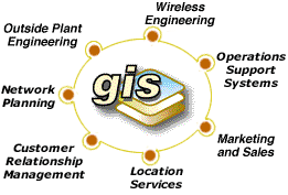
GIS
Use in Telecommunications Growing
To be competitive,
telecommunications providers depend on a smoothly functioning
work flow process that integrates information for marketing, demand
forecasting, engineering, customer management, operations support,
and fleet management. Although telecommunications providers generally
have the same needs for information, how the work flow is organized
can vary significantly from company to company.
 |
|
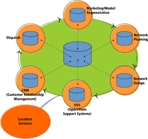
Telecommunications
companies are integrating GIS into the
overall work flow.
|
Historically
telecommunications companies have used an assortment of information
systems-some developed in-house, some purchased-that were never
designed to work together. When these systems were implemented,
there was no perceived requirement for information sharing. Today
telecommunications companies operate networks that have equipment
from multiple vendors and lease bandwidth and antenna sites from
other companies. Mergers with, or acquisition of, other companies
require the incorporation of, or at least interaction with, completely
foreign networks.
The need for
information sharing within companies and interoperability between
systems has been recognized by the telecommunications industry
for a long time. Originally founded in 1865 as International Telegraph
Union, the International Telecommunications Union (ITU) promotes
standards in equipment that guarantee generalized interconnection
between communication systems. To improve interoperability, ITU
has developed the Telecommunications Management Network (TMN),
a method of standardizing business organization. This hierarchy
of support systems specifies interoperability through the use
of industry-standard protocols. Geospatial applications need to
support this same level of interoperability if GIS is to work
well within this TMN-structured environment.
Many current
applications of GIS in the telecommunications industry began as
departmental tools that worked within a well-defined scope. These
GIS-based tools have helped automate business processes and increase
the efficiency of operations. The following sections describe
how telecommunications companies have integrated GIS into the
overall work flow.
Marketing/Market
Segmentation
Telecommunications
providers are tied to geography more closely than many other types
of businesses. They operate within service areas and the infrastructure
that delivers services is linked directly to the location of each
customer. Telecommunications companies segment the characteristics
for both consumer and business customers geographically using
GIS. This not only lets them market more effectively but also
helps them forecast the demand for services. Both targeting customers
and predicting where and when growth will occur involves integrating
corporate intelligence, demographic data, and information about
the progress of building projects in the area with location data
and applying various modeling techniques. The information obtained
from this analysis drives network investment budgets and marketing
campaigns.
Operations
Support Systems
Operations
Support Systems (OSS) make sure that the network functions properly.
OSS includes activities such as network monitoring, outage management,
billing, and testing. With a shared GIS database, staff members
have instant access to customer status and history, existing plant
records, and signal quality information to support updates, maintenance
and repairs to the network.
Intelligent
objects modeled in ArcGIS not only have rules that speed the design
process but also can reflect the status of network elements. A
query can identify features in a network element layer that are
at 80 percent of capacity more than half of the time. The switches,
base stations, and other features selected by this query would
be candidates for capacity enhancements. The ability to anticipate
problems and prevent outages before they occur is another tool
that enables carriers to be more competitive and reduce costs.
This so-called "near real-time" monitoring of networks necessitates
integration of several systems using industry standard interoperability
protocols.
 |
|
GIS-based
analysis is used for decision support in capital planning.
|
Capacity
and Capital Planning
Information
generated by marketing and market segmentation activities that
define current and future communication demands can be used to
create a logical network of capacities and estimate the capital
spending required to build this capacity. GIS is widely used in
decision support for capital planning. Effective capacity planning
uses current data describing the existing plant, the demand information
from the marketing phase, and network performance information
from OSS.
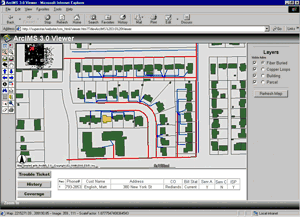
Wireline
Engineering
Wireline engineering
systems are GIS applications that work with the design and geographic
layout of a company's outside plant infrastructure. Engineering
applications allow for quick review and modeling of network routes,
automation of the work order process, and high volume cartographic
output to support technicians in the field.
ArcGIS can
model intelligent objects in the network and associate rules with
features. Through the use of industry-specific data models, real-world
behavior can be captured in these objects. [See
the accompanying article, "Telecommunications Data Model Available."]
For example, a fiber cable object can be created with rules that
would not allow it to connect to a copper splice. This capability
greatly enhances design performance. Because they use an industry-standard
development platform, ArcGIS-based engineering systems are interoperable.
Third party software that schematically represents networks has
been integrated with ArcGIS so that users can toggle between logical
and physical views of the network.
 |
|
Engineering
applications allow for quick review and modeling of network
routes, automation of the work order process, and high volume
cartographic output to support technicians in the field.
|
Wireless
Engineering
Nowhere is
competition in the telecommunications industry more intense than
in the wireless sector. While most second generation networks
have rolled out, new wireless network technologies are forcing
carriers to redesign all or parts of their networks. Designing
and building a wireless network is a costly process that involves
several iterations of planning and testing. Having paid handsomely
for third generation (3G) licenses, many carriers are highly motivated
to reduce the cost of building new networks.
Performing
sophisticated GIS analysis on optimized geographic data can reduce
planning and design costs. In some cases, effective use of geographic
resources has made the difference between success or failure for
a telecommunications company. Preliminary analysis with GIS uses
customer, terrain, and landownership information and provides
planners with potential antenna sites. The initial network configuration
is evaluated using wave propagation modeling that simulates the
wireless coverage resulting from a configuration. Once an optimal
model is devised, engineers test the configuration in the field.
The process is repeated until the configuration provides optimal
coverage for the area. Wireless engineering applications illustrate
that sharing information and geographic data between phases of
the work flow can reduce data redundancy while streamlining processes.
Using GIS to limit the number of design iterations and curtail
costly field testing provides significant savings for telecommunications
providers.
 |
|
With
GIS, call center operators can access all the information
on a customer and the associated network based on location.
|
Customer
Relationship Management
In today's
competitive telecommunications market, customer service is the
number one differentiator for companies. Customer relationship
management (CRM) applications improve the relationship between
the company and its customers. Timely service provisioning, response
to customer queries, and reporting on network performance are
aspects of CRM. With GIS, call center operators can access all
the information on a customer and the associated network based
on location. Databases containing information on outside plant
infrastructure, signal quality, and equipment can be integrated
using GIS and made available using a corporate Intranet.
In CRM, Tier
1 handling means the customer's issue is resolved with the initial
call. Tier 2 calls require initiating a trouble-ticket and obtaining
additional information. Carriers who have successfully implemented
GIS support for CRM achieve higher Tier 1 handling and customer
service is performed more quickly and economically. With CRM contacts
at an all-time high, improving CRM operations can make a big impact
on the bottomline of a carrier. In the wireless sector, "churn"
refers to the rate that customers jump from one service provider
to another. For many carriers, customer churn is the single largest
cost factor. GIS improves the speed and quality of contact handling,
augments customer satisfaction, and reduces churn.
Fleet
Management/Dispatch
Communications
companies must manage and route service vehicles for outage response
and service provisioning. An efficient dispatch process balances
drive times, territories, and the skill sets of individual technicians.
GIS routing applications can produce itineraries that take each
of these factors into account. Optimizing the dispatch and routing
of service vehicles results in significant cost and time savings
and increased customer satisfaction because technicians can often
specify time windows for service calls of two hours or less.
Putting
It All Together: Enterprise GIS
When GIS applications
servicing various phases of the work flow are interoperable and
a networked GIS distributes geographic data to desktops and mobile
devices, the value of GIS to the organization moves well beyond
that of a departmental tool. For example, a sales representative
can make a compelling business case for the sale of bandwidth
to a corporate prospect by showing the prospect's location in
relation to the telecommunications company's infrastructure. Network
infrastructure provided by AM/FM systems is used for decision
support in the provisioning process. Technicians in the field
locate the correct manhole, pole, or access point by using the
same data. Coverage maps and testing data for wireless networks
can be instantly viewed by call center operators dealing with
customer complaints. More complex applications include geospatial
data in data warehousing systems and are used in conjunction with
On Line Analytical Processing (OLAP) clients to add a "where"
dimension to corporate business intelligence.
The ArcGIS
8.1 suite is a fully scalable GIS that can work in a heterogeneous
environment and support the tools, databases, and networks that
telecommunications companies require. ESRI is working to integrate
GIS applications in the TMN hierarchy. This will improve enterprise
deployments and resolve interoperability issues. Field engineering
tools and the use of mobile networks making geographic information
available through wireless devices to business and consumer users
will further increase the value of GIS. Telecommunications executives
who make complex decisions will find GIS indispensable for decision
support. GIS provides an overview of the company and the work
flow. The addition of location services driven by GIS will generate
additional revenue for telecommunications carriers and their business
partners.
The investment
telecommunications companies make in geospatial data and technology
will yield benefits in business process automation, improved decision
support, and value-added services for years to come.
For more information
on the use of GIS in the telecommunications industry, contact
Napoleon
Garcia
Telecommunications Consultant
E-mail: [email protected]
|