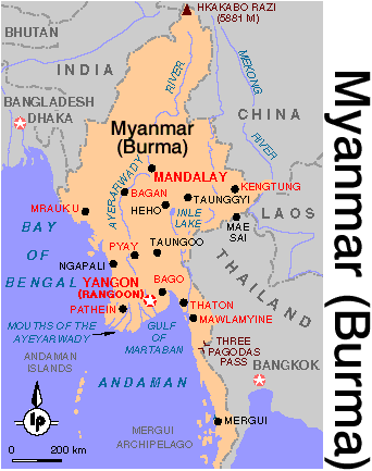
 Myanmar is one of the largest country in
South East Asia, bordering the Andaman Sea, the Bay of Bengal, Bangladesh(193 km),
India(1,463 km), China(2,185 km), Laos(235 km) and Thailand(1,800 km).
Myanmar is one of the largest country in
South East Asia, bordering the Andaman Sea, the Bay of Bengal, Bangladesh(193 km),
India(1,463 km), China(2,185 km), Laos(235 km) and Thailand(1,800 km).MYANMAR (BURMA)
Myanmar is one of the largest country in
South East Asia, bordering the Andaman Sea, the Bay of Bengal, Bangladesh(193 km),
India(1,463 km), China(2,185 km), Laos(235 km) and Thailand(1,800 km).
Myanmar is a nation of many races - some 130 ethnic groups make up its population of nearly 47 million. The Majority of Myanmar's people are Barmars but Shan, Kachin, Kayin, Mon, Rakhine and other are also prominent throughout the country.
Myanmar's ethnically diverse population is a result of three major migrations from Tibet and Central Asia, The cradle of humanity. The people of Myanmar are descendants of three branches: the Mon-Khmer, the Tibeto-Burman and the Thai-Chinese.
Myanmar's climate is tropical: during the cool season from late November through February, temperature are pleasantly mild ranging from 21 C to 28 C; the hot season from March to May can see mercury reach as high as 45 C; and during the months of the rainy season, from June to October short rainstorms are frequent in the late afternoons.
YANGON (RANGOON)
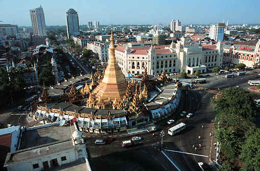 Capital of Myanmar. It is the country's largest
and principal seaport and its main commercial, manufacturing and transportation center.
Capital of Myanmar. It is the country's largest
and principal seaport and its main commercial, manufacturing and transportation center.
The settlement first came into prominence in the 1775 when King Aiaungpaya(the founder of the Kon-Baung, last dynasty of the Burmese Kings) conquer the village Dagon, he renamed it to Yangon, means 'the end of strife'. The village's strategic location in fact warranted a total victory over Lower Myanmar. In 1851 the town was annexed by the Britain and subsequently rebounded. The new city was designed and constructed in checker board fashion, with the roads running north-south and east-west. It's architect was the same Lieutenant Fraser that also designed Singapore. Yangon was captured by the British in 1824, but they relinquished control two years later. It began to develop as a modern community in the late 19th century after it had again come under British rule at the conclusion of the Second Anglo-Burmese War in 1852. During World War II (1939-1945) the city was occupied by the Japanese forces. When Myanmar achieved independence in 1948, Yangon became the capital.
Nowadays it is bustling city of some 5 million inhabitants, covering an area of over 570 sq km.
MANDALAY
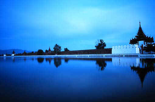 Mandalay city is in central
Myanmar, capital of
Mandalay Division, on the Irrawady river. Mandalay is second largest city. It is also
major trading and communications center in northern and central Myanmar and is linked by
rail with other large Myanmar cities.
Mandalay city is in central
Myanmar, capital of
Mandalay Division, on the Irrawady river. Mandalay is second largest city. It is also
major trading and communications center in northern and central Myanmar and is linked by
rail with other large Myanmar cities.
Mandalay is a cultural and religious center of Buddhism, having many monasteries and more than 700 pagodas of great beauty. Built in 1850, Mandalay was the capital of the independent Kingdom of Burma until captured by the British in 1885, after which it was the headquarters of Upper Burma. The Japanese Captured Burma in 1942.
BAGAN
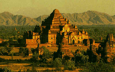 Located 193 km south of Mandalay and covering 42
km2, Bagan is one of the archeological sites in Asia. Also known the city of the four
million pagodas. Bagan is one of the ancient capitals of Myanmar. There are more than 2000
pagodas built during the Bagan Dynasty founded by Anawratha in 1044 AD.
Located 193 km south of Mandalay and covering 42
km2, Bagan is one of the archeological sites in Asia. Also known the city of the four
million pagodas. Bagan is one of the ancient capitals of Myanmar. There are more than 2000
pagodas built during the Bagan Dynasty founded by Anawratha in 1044 AD.
[ HOME ][ FAMOUS PAGODAS ][ BUDDHA STATUES IN MYANMAR ]
[ BEAUTY OF MYANMAR ][ BUDDHA STATUES IN JAPAN ]
[ BEAUTY OF JAPAN ][ ABOUT MYSELF ][ MYANMAR POEMS ]
[ SIGN MY GUEST BOOK ][ VIEW MY GUEST BOOK ]
