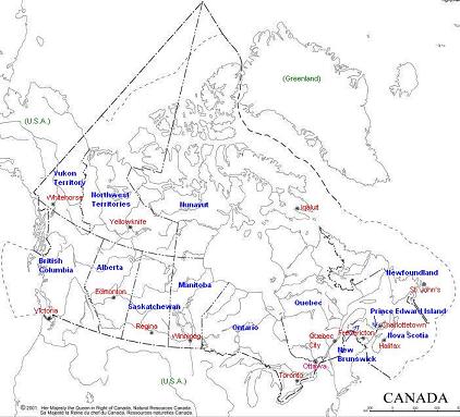
blue: province, territory
red: provincial/territorial capital
pink: federal capital
capital population
(per StatsCan 2003 est based on 1996 census)
Canada Ottawa (Ontario) 31,499,560 (31.5 million)
Newfoundland St. John's 531,145
Prince Edward Island (P.E.I.) Charlottetown 140,412
Nova Scotia Halifax 944,456
New Brunswick Fredericton 756,368
Quebec Quebec City 7,467,626
Ontario Toronto 12,109,514
Manitoba Winnipeg 1,150,564
Saskatchewan Regina 1,009,225
Alberta Edmonton 3,134,286
British Columbia Victoria 4,155,779
Nunavut Iqaluit 28,955
Northwest Territories Yellowknife 41,389
Yukon Territory Whitehorse 29,841
Other information
Canada's...
* size/area: 9,984,670 sq. km (2nd largest country in the world)
* biggest province in area: Quebec (1,542,056 sq. km)
* smallest province in area: Prince Edward Island (5,660 sq. km)
* biggest territory in area: Nunavut (2,093,190 sq. km)
* highest mountain: Mt. Logan, Yukon Territory (5,959 metres)
* longest river: Mackenzie River, N.W.T. (4,241 kilometres)
* biggest city (population): Toronto (5,029,900 in 2002)
* newest province: Newfoundland (1949)
* newest territory: Nunavut (1999)
* oldest provinces: Ontario, Quebec, Nova Scotia, New Brunswick (1867)
* birthdate: July 1, 1867 (Confederation)
- - - - - - - - - - - - - - - - - - - - - - - - - - - - - - - - - - - - -
Click here to hear the Provinces Song.
Click here to hear O Canada.
geographic statistics from Facts about Canada, Natural Resources Canada
population statistics from Statistics Canada