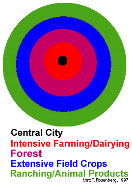
There are four rings of agricultural activity surrounding the city. Dairying and intensive farming occur in the ring closest to the city. Since vegetables, fruit, milk and other dairy products must get to market quickly, they would be produced close to the city (remember, we don't have refrigerated oxcarts!)
Timber and firewood would be produced for fuel and building materials in the second zone. Before industrialization (and coal power), wood was a very important fuel for heating and cooking. Wood is very heavy and difficult to transport so it is located as close to the city as possible.
The third zone consists of extensive fields crops such as grains for bread. Since grains last longer than dairy products and are much lighter than fuel, reducing transport costs, they can be located further from the city.
Ranching is located in the final ring surrounding the central city. Animals can be raised far from the city because they are self-transporting. Animals can walk to the central city for sale or for butchering.
Beyond the fourth ring lies the unoccupied wilderness, which is too great a distance from the central city for any type of agricultural product.
Even though the Von Th³nen model was created in a time before factories, highways, and even railroads, it is still an important model in geography. The Von Th³nen model is an excellent illustration of the balance between land cost and transportation costs. As one gets closer to a city, the price of land increases. The farmers of the Isolated State balance the cost of transportation, land, and profit and produce the most cost-effective product for market. Of course, in the real world, things don't happen as they would in a model.