GENERAL INFORMATION
1. Your field study, and the route taken by the
bus are your learning environment for the day. Full attention must be given
to the information given and discussed on the bus.
2. Your worksheet must be used to record data
at each of the stops. Additional information you learn en route must also
be recorded.
3. Exchange your window seat for an aisle seat
after each stop.
4. Students must work together at each stop. This
includes the Warsaw Caves, where working together ensures safety.
5. Be courteous to your fellow students, your
teachers, and the bus driver! Please do not use foul language. Please do
not litter.
6. Make this field trip worthwhile! Learn a lot,
and enjoy being in a natural setting with friends.
DATA COLLECTION AT STOP A - The Oak Ridges Interlobate
Moraine
1. Sketch the contour patterns of the moraine
as if you were floating above it.
2. Describe the topography in a detailed paragraph
3. Draw a sketch of the topography of, and the
vegetation covering the moraine.
4. Sketch a diagram to illustrate how this particular
moraine was formed.
5. List the land uses for different aspects of
the moraine.
DATA COLLECTION AT STOP B - The Omemee Esker
1. Each student must randomly collect 20 pebbles
off the edge of the esker. Do not collect rocks on the road on the top.
2. Sort the pebbles into four groups according
to whether they are rounded or angular.
3. Record the number of rocks you placed under
each of the following four headings: Angular,
Sub-angular, Sub-rounded, Rounded.
4. Back in the class, compare your results
with the results of four other students. (ie. 100 rocks altogether).
5. Calculate the per cent totals of the rocks
in each category.
6. Graph your results in a bar graph, and write
a paragraph to explain why the graph shows these results.
7. Sketch a diagram to explain how an esker was
formed. Do you think the glacial river that formed this feature was fast-moving
or slow-moving? Explain your answer.
DATA COLLECTION AT STOP C - The Peterborough
Drumlin Field
1. Using a compass, find out in which direction
the drumlin is aligned.
2. Which is the gentle, or tapered end?
3. Which end is the blunt, or steep end?
4. From which direction did the glacier advance
when this drumlin was formed?
5. Embedded into the drumlin are many large rocks.
What is the name given to these boulders? Describe the colour and structure
of a few of the rocks. Indicate their probable place of origin, and explain
how these rocks help to explain the direction of glacial movement.
6. From your vantage point, identify other surrounding
drumlins. List at least four different land uses of these drumlins, and
the one on which you are standing. Sketch a map of the drumlins and their
land uses.
7. Back in the class, look at the Peterborough
Topographic Sheet, find the Peterborough Drumlin, and determine the elevation
of this drumlin above the Trent Canal.
DATA COLLECTION AT STOP D - The Lakefield Limestone
Quarry
Collect fossils using your rock hammer (REMEMBER TO WEAR
GLASSES OR GOGGLES WHEN HAMMERING!!!).
Have fun! Bring any really cool fossils to Mrs. Whitfield
so she can take a look too! You may want to bring some fossils home for
further identification or possible dating. (Remember, the bigger the sample,
the heavier!!!)
1. Sketch a picture of the quarry.
2. Look at the different layers of rock. How many
centimetres thick is each layer? How hard is each layer? (scrape with a
pen).
3. Back in the class, What is a quarry?
4. How was this limestone formed?
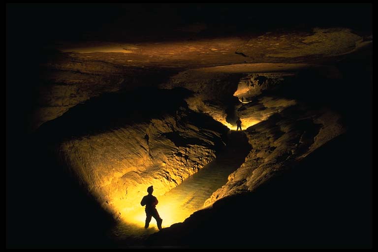
DATA COLLECTION AT STOP E - The Karst Topography
of the Warsaw Caves
1. Explore the caves.
2. Draw a map of one of the caves you visited.
Try to include an idea of the sizes of the tunnels / rooms you went through.
Include a scale and a title for your map.
3. If you choose not to go into the caves, walk
along the "kettles" trail. Find the largest pothole, and some smaller ones.
Draw a sketch of what you saw (try to give some indication of scale - ie,
draw a person next to it.) How did these features form?
| STOP A
Contour patterns /2 marks Description of topography /3 marks Sketch of moraine and vegetation /5 marks Diagram of ice lobes and moraine formation /5 marks List of land uses /5 marks |
STOP B
100 rocks /2 marks Bar graph /5 marks Sketch diagram of esker /5 marks Fast or slow moving? /3 marks |
STOP C
Drumlin alignment /2 marks Gentle end /1 mark Blunt end /1 mark Ice advance /1 mark What term for rocks? /1 mark -Colour /1 mark -Place of origin /1 mark -Come from? /2 marks 4 land uses /4 marks Sketch map of drumlins and uses /5 marks # of feet above the Trent Canal /1 mark |
STOP D
Sketch of quarry /5 marks Layers approx. thickness /1 mark Rock hardness? /1 mark Definition of quarry /3 marks Formation of limestone /5 marks |
STOP E
Map of caves /5 marks TOTAL /75marks |