|
Part 1: The Pacific Coast and Idaho Part 2: Montana and Wyoming Part 3: The Great Plains Part 4: Colorado, Utah and the desert |
|
On this and other pages linking to JPEGs from the Adventure, image sizes are usually less than 50 KB.
Wildflowers, Glacier Park, MT 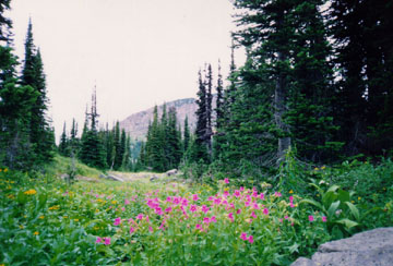
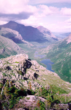
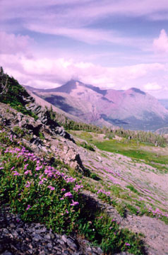
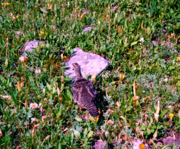
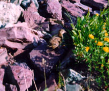
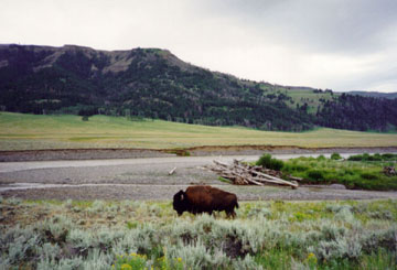
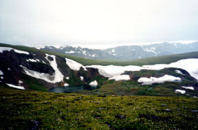
7:30 PM: Driving along the Flathead River, Montana. It's a sweltering day and I swim again. I'm already in love with Montana. I took a photo from the picteresque town of Ronan, MT, looking towards the Rocky Mountains. Looking east from Ronan, MT I have seen a blue heron; two adults and a chick in an osprey nest, and a road runner all on the same day. I go by the National Bison Range, where I see buffalo as dark brown dots on a grassy hillside miles away. 10:00 PM: Near Polson, MT, I drive west towards Lake Mary Ronan State Park. There is far-off lightning on the east side of Flathead Lake, and I have traveled away from it. I camp in the park. 3:45 AM, 7/28: The storm has followed me west; After getting rained on, I sleep in my car for a few hours. 7:00 AM: I take a 90-minute hike around the lake after the rain stops. I am entranced by the squirrels, small, gray and very cherubic. I pack up my stuff and drive down to the lake, where I watch another storm come over the lake. 2:45 PM: I arrive at Glacier Park. The weather is unpredictable with thunderheads in the distance. I swim in McDonald Lake, just a couple hundred yards away from the main visitor center on the west side of the park. This beautiful place, which I rate the equal of Yosemite, is nearly deserted in the peak of summer. 3:45 PM: I start a hike up the hill south of the lake, on the Sperry Trail, heading for Snyder Lake. After an hour of trudging up steep terrain, a storm hits as I pass two large cedar trees. I walk past, noting they would come in handy in case of heavy storm. A minute later, I turn around amidst the first big raindrops and take shelter underneath. The storm lashes the hillside, felling trees with loud cracks only a few hundred yards away. After sitting under the tree for 90 minutes, joined by fellow hikers Jen and Wendy from Portland, the rain backs down enough that I decide to head back down to the car. The storm has felled half a dozen big firs across my trail. 7:45 PM; I drove around the park for awhile, took more pictures. I head toward Logan Pass on a narrow mountain road which take you to the eastern side of the park. I discover that a big mudslide has closed the road. As dusk approaches I watch the Rockies bathe in faint pink and orange hues. Despite the storm, I am enjoying myself immensely. I camp at Apgar and sleep soundly in the dead quiet. 10:10 AM, 7/29/98: After coffee and breakfast, I swam again in McDonald Lake. 1:15 PM: After looking at maps for awhile, I decide to take a major hike on the continental divide. I hike the loop trail towards Granite Peak Chalet: 3.6 miles one way, with a 2200' vertical climb. From the trailhead the view is amazing, but I know the trail will have stunning views throughout. I'm carrying a gallon of water and lots of food. 4:45 PM; I'm at the Chalet, a rustic stone building very far from any road. It sits just below the continental divide, overlooking an alpine lake. There is a ranger with a dozen hikers who have set up viewing scopes on the lake. They spot a grizzly bear and are very excited. I am able to see the mother bear and two cubs with naked eye, but I take a quick look through the scope and see that this mother bear is as big around as a dinner table. I decide to continue my ascent up to SwiftCurrent Pass, another 600 feet of elevation from the chalet. This is one of two steep trails that go up to the ridge that makes up the divide. Already the altitude is getting to me, and I have to hike slowly to avoid getting really winded. I'm near 9000 feet elevation. Looking east from Swiftcurrent Pass, Glacier Park, MT I keep walking until finally I reach the divide. The trail crosses the summit at a saddle between two ridges that are buried in mist as clouds blow by. I decide instead to follow the trail past the top and down the eastern side of the divide, just to see that side of the park, since I still haven't been able to drive over there. (different view) Looking east from Swiftcurrent Pass, Glacier Park, MT The two pictures supplied here only give a hint at the panoramic views; most of the scenery was too big to fit in the viewfinder of my primitive camera. 6:00 PM: After many landscape photos from the divide, I begin my descent. A large speckled bird catches my eye, just off the trail. Ptarmigan hen, Glacier Park, MT It's making very strange sounds, and as I walk closer, it stays frozen. Finally I am a few feet away and it begins moving away, now clucking even louder. I then see baby birds moving underfoot, previously unseen due to their camoflauge of spots. The mom has continued walking uphill, and all but one of the half-dozen fluffball offspring have rejoined her. I photographed one wayward baby as it made its way uphill towards mom. I still don't know if these were willow or rock ptarmigans. Ptarmigan chick, Glacier Park, MT 8:15 PM: I get back to the car and drive down for one last swim in McDonald Lake. Reflecting, I realize this is probably the highlight of the trip; I hadn't planned on taking any hikes over an hour or two, but the land captured my imagination. I'm sore, but ready to hit the road for an hour or two. I drove to Great Falls, MT and got a motel room. 8:35 AM, 7/30/98: Leaving Great Falls, MT. I must start putting the miles in today, while seeing a bit more of the Rockies. I head towards Yellowstone and the Beartooth Mountains along the Wyoming/Montana border. 2:00 PM: On Hwy 89 in Montana, I stop along the Yellowstone River, which is swollen from the recent rains. A thunderhead appears to the west, and it begins raining hard. 3:15 PM: At the main Yellowstone Park entrance in Wyoming, I plan a drive through the park's northern edge. I see a herd of elk and a couple of black bears playing on a hillside. I continue heading eastward, and the rain begins. 4:30 PM: in the northeast corner of the park is the Lamar River, and a lone buffalo walks along the river's edge, perhaps 50 feet from the road. I stop and snap photos, and traffic halts as cars in both directions stop for pics. This is my kind of road. Buffalo, Lamar River, western Yellowstone Park 5:15 PM: Silver Gate, MT: The storm has followed me eastward and is now illuminating the whole town with huge lightning strikes. 7:00 PM: Beartooth Pass, WY: This mountainous area, northeast of Yellowstone Park, straddles the MT/WY border and contains one of the most treacherous roads I've ever seen. The road ascends upwards of 10,000 feet here, which is more scary than exciting when it's raining hard. Beartooth Pass, Wyoming/Montana border I finally traverse the pass and get back down to civilization (Red Lodge, MT). 12:30 AM, 7/31/98: After a few more hours of caffeine-aided driving, I stop at a rest area just short of the South Dakota border. |
|
Part 1: The Pacific Coast and Idaho Part 2: Montana and Wyoming Part 3: The Great Plains Part 4: Colorado, Utah and the desert Home Page |