|
Geographic Information System
(GIS) and its related technologies of remote sensing, cartography,
global positioning, and more, are valuable tools that can assist
Natural Resources Conservation Service (NRCS) and customers in
achieving our natural resource management objectives.
This long range plan outlines
the strategy and provides the overall framework for the management
and coordination of GIS activities by Major Land Resource Area
(MLRA) Soil Survey Project Offices in Indiana.
|
A GIS is a computer based technology,
using computer software and hardware designed to input, manage,
manipulate, analyze, and display geographically referenced digital
data.
It is important to think of GIS
as a long term investment and in terms of "building a GIS."
A GIS begins with the idea of storing and maintaining map information
on computers, but its main value lies in its ability to link tables
of data to a map, calculate areas, perform aggregation, provide
spatial analysis, perform proximity analysis, show adjacency,
and quantify landscape relationships.
This GIS Plan Initiative identifies
the need to update, digitize, and maintain the soil surveys of
Indiana and identifies the product of the future as a digital
soil survey to be completed by 2005. The realization of producing
a state-of-the-art product provides a catalyst for our GIS activities.
Much time and energy has been
spent promoting the concept of a proper photo base and developing
the soils database correctly the first time. However, we recognize
that we need to look beyond database development, to the real
power of GIS - manipulating, analyzing and displaying the data.
In the last ten years, many basic
technical and organizational decisions have been made to build
the NRCS GIS System. Cooperative efforts have been initiated,
the information required has been determined and accuracy, base
map, and data sharing questions have been addressed.
The underlying philosophy behind
our efforts has been that "It is the responsibility of
all GIS users to:"
- Maintain the integrity and accuracy of the original data.
- Eliminate duplication and waste in developing digital databases.
- Facilitate the transfer of data between different systems.
The objective is to incorporate
GIS and cartography technology into NRCS operations resulting
in an increase in the effectiveness and efficiency of the NRCS
application in addressing all resources concerned within Indiana
through the following initiatives:
- Improve the understanding and use of GIS, remote sensing, and cartography within NRCS.
- Develop technical capabilities and provide technical leadership for use of GIS, remote sensing, and cartographic technology.
- Develop plans, policy, procedures and technical information for use in Indiana.
- Coordinate GIS, remote sensing, and cartographic activities within NRCS in association with federal, state and local agencies, and with the private sector.
|
CUSTOMERS
The GIS customers have been many,
with a diversity of needs and expectations. Working with local
units of government has been the priority of the soil survey .
We have met with representatives (typically supervisors of assessments)
for most counties in an attempt to coordinate efforts in "building
GIS's" at the local level.
Our GIS customer will remain
local units of government, MOU partners, "system users,"
and "NRCS Conservation Planners." But there will be
many more of them! The demand and user expectations are increasing
for resource information databases, like soil survey, incorporated
into GIS. More external users are beginning to use this technology
such as: farmers, planners, engineers, and many others. For example,
the trend toward precision farming has increased the number of
requests for digital soil survey information.
SOFTWARE AND HARDWARE
System configuration is based on size and complexity of the database, the number and type of users, intended applications, and budget limitations. Projected hardware and software needs for a GIS site location at each MLRA Soil Survey Project Office is outline below:
|
| |
Once this GIS hardware and software
becomes available to MLRA Project Office sites with the proper
networking systems, the performance of hardware and software should
continue to increase while the cost should decrease. Hardware
replacement should be expected every 2 to 4 years. Operating
systems, GIS software, and database software should be upgraded
on a similar, but staggered schedule.
|
The digital orthophotography,
digital soils, and digital land cover data layers are the most
complex and expensive to develop. The strategy is to continue
to develop these layers over a period of 5 to 10 years through
cooperative agreements with federal, state, local and private
organizations.
Assisting with data for project
activities for field offices within those MLRA Project Office
areas will add to the dataset, such as watershed and other area
wide planning, WRP, EQIP, and others. These additional GIS projects
could be developed on a short turn around time table. A protocol
and detail work plan will need to be developed for the GIS in
project offices.
|
Present and future benefits of
GIS applications at MLRA Offices can be tremendous. GIS provides
a mechanism to keep spatial and attribute data current for natural
resource assessment and planning activities.
GIS is at the heart of future
soil survey update and maintenance efforts. The
system and its digital databases will allow the soil scientist
to acquire site-specific information, including three dimensional
(FUTURE GIS APPLICATION AND PRODUCTS)
soil-landscape models, soil-landscape interpretations, and soil
maps. This will allow the field work to be focused more where
it is needed and thus reducing the overall amount of field work.
The analytical benefits of GIS
for planning activities cannot be overstated. Performing
massive geographical analysis manually is not practical when multiple
"what if" scenarios are needed. After databases are
developed, planning options can be processed electronically many
times with little effort. Each option can be evaluated in terms
of environmental impacts, economic implications, land use, and
potential use conflicts. The step by step accountability that
GIS application demands, will drive the needs for involved planning
decisions.
Potential resource layers that can be utilized in the MLRA Soil Survey update efforts are as follows:
- Hydrography Layer
- Aquifer Distribution and depth
- Utilities; power, telephone, gas, cable, oil
- Cultural features, roads, towns, county boundaries, state boundaries
- Geological map, glacial, bedrock
- USGS, 7.5 min topography data
|
It is time for everyone in NRCS
to be involved and/or using GIS technology. The way we organize,
the role individuals play, and how they interact have a direct
impact on the vision of our GIS and its long term survivability.
GIS Sites
In addition to the State office
GIS site, there will be three MLRA GIS sites established (see
figure 1). These sites will be located at the MLRA Soil Survey
Project Offices. The Indianapolis, North Vernon, and Winamac/Plymouth
MLRA Soil Survey Project Offices will serve as GIS locations.
These offices could provide GIS assistance for the field offices
within their area, with the guidance of the State Office GIS staff.
From the state office site, GIS
support, direction, and training will be provided to the three
MLRA sites (MLRA Offices). The MLRA sites can service whatever
field office structure (with GIS functions) within their areas.
These three MLRA sites are the
top priority for GIS site development to facilitate soil survey
and other efforts. It is recommended that these sites be made
fully functional within two years.
|
The original vision for the MLRA Soil Survey Project Office was that they would be the storehouse of a permanent, dynamic, growing soil information base. The goal is to have data digitized and stored electronically. The office would service the needs of both technical and non-technical users. The
heart of the soils information
center would be a GIS. All future soil survey update and maintenance
activities are to be performed from these regional locations.
It is recommended that the scope
of these offices be broadened to include GIS and technology functions.
These MLRA GIS locations would be our GIS hubs that would eventually
be networked to our field locations.
Staffing of the MLRA GIS locations
will vary depending on the major resource concerns and workloads
in each area. Soil Scientist expertise is required for soil survey
update, maintenance, and providing technical soil services. Another
key position that must be established and filled is a MLRA
Resource Analyst for these offices. Without this position
GIS expectations will not be realized.
The following GIS position and
responsibilities are suggested:
MLRA Resource Analyst
-- Responsible for system operation, database management
(digitizing/scanning), display of data, and GIS application at
the MLRA Office. They will assist and train field office team
members with using digital soil survey information in their areas.
They will assist the NRCS Leadership and the MLRA Project and
Technology Support Team Leaders in marketing and promoting GIS
efforts within their areas.
TRAINING
New "system users"
and "results users" will require formal GIS training.
ArcView and ArcInfo training will be needed for the MLRA Resource
Analyst. On-the-job training and user workshops should be offered
by the State GIS Specialist Team and others.
COSTS
Database development will be
the most expensive item in GIS implementation over the next 5
years. Digital orthophotography for Indiana will be obtained
from the cooperative venture of FSA, NRCS, and USGS. Developing
a digital soil survey for Indiana is estimated at over 4 million
dollars (about 80 staff years). Other digital resource layers
identified through project activities (PL-566, WRP, and others)
would increase the GIS cost and workload for the Resource Analyst
at those MLRA locations.
Hardware and software estimated
cost would total about $15,000 each year over the next 5 years,
which includes replacement/upgrade and training cost annually.
Also, this includes about $7,000 start-up cost for each MLRA
GIS site, obtaining hardware, software, and networking with field
offices that have an existing GIS structure.
FUNDING
The key to implementing GIS technology
and building a GIS for the MLRA offices is through a funding coalition
of federal, state, local, and private sponsors. An estimated
cost of over $900,000 dollars per year for 5 years is needed to
develop the soils digital data layers. The funding would increase
if other project data layers (for PL-566, WRP, EQIP, and others)
are generated at the MLRA offices. No one organization can, or
should be, expected to cover this cost alone.Current cooperative agreements between
NRCS and county government provide for about $90,000 annually
towards digitizing soil survey information. The present cost
share is approximately 50% NRCS and 50% local. There is a need
to solicit additional funds from state government and private
sector to support the digitizing effort.
The scope of these agreements
need to be broadened to include additional data layers beyond
digital soils and digital orthophotography. More partners need
to be included to share in the cost of developing these data layers.
The cost share rate needs to be adjusted to get more for the
NRCS dollar.
Initiate GIS project protocol for all watershed, WRP, EQIP, and other planning efforts at the field office level.
MLRA Soil Survey Project Service Areas
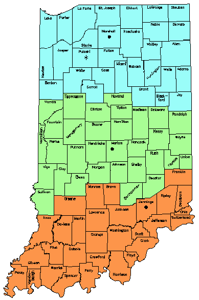
Figure 1 |
.
MLRA
Project Soil Survey Office
- Temporary MLRA Soil Survey Office
- USDA-NRCS-IN June, 1998