Well, folks, here's vol III from the Annals of Epic Rides 2001
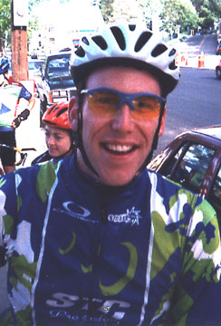
by the fabulous MARK ABRAMSON
For the past few years, a merry bunch of us have been making the trek north to conquer the hell of (our) north - the various gaps surrounding route 100 in Vermont. From north to south and east to west, these are: Appalachian Gap, Lincoln Gap, Middlebury Gap, Brandon Gap, Moretown Gap, Roxbury Gap, and Rochester Mountain Gap. This year's Vermont Deathride(tm) sought out to cover six of the best/worst - Lincoln, Ap, Roxbury, Rochester, Middlebury, and Brandon.
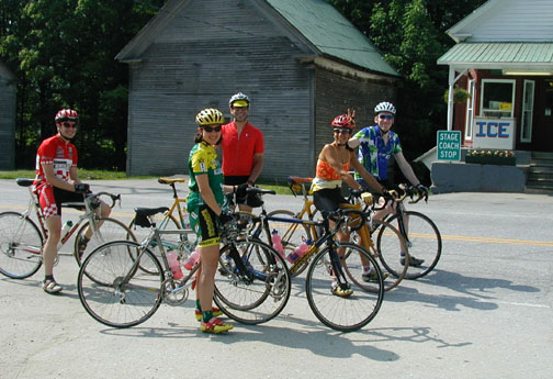
A few last minute cancellations from several members left us with a core group of six hapless souls: Forest, Stefan, Barbara, Michele, Ed, and Mark. We had a leisurely morning of hydration and waffles with all sorts of delectable toppings provided by New York's finest along with some arm-wrecking whipped cream whipping by Forest. After making ourselves sick with four Belgian waffles per person (a key when doing a long ride), we packed up the cars for a short jaunt north to the start of the ride -- Hancock, VT.
We parked at the intersection of 100 and the Middlebury Gap road so that we could roll down Middlebury and right into our cars and/or the restaurant/hotel/stream/morgue at the bottom. A little more nervous doodling and bike prep, and we were off on our ride by 10AM, heading north on route 100. Of course, Forest and I kept sprinting for all of the town lines on route 100 as we climbed up and over Granville Gulf, just to make sure we were sufficiently wasted on such a long, hot day. The temp at this point was probably in the mid 80's, with some pretty high humidity due to the fog that had just lifted.
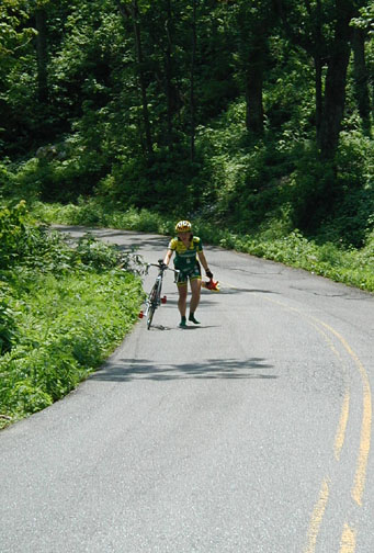
We soon reached Warren, VT, and took a left onto aptly named Lincoln Gap Road. We all stayed together until the "banjo house" -- called so because it looks like the kind of place that should have some hillbilly with no teeth plucking a banjo on the porch. Of course there were a variety of toys, farm machinery, and truck bodies in the front yard. Coincidentally, this is where the steep stuff starts. And I do mean steep. After much discussion over the past few years, it has been determined that Lincoln Gap may not be rideable after surmounting a Gap or two before hand. It is a mere 1 1/2-2 miles of "steep stuff", but it runs about 20% the whole way. We split up right away, with Forest taking the lead with Stefan right on his wheel. I was with them for about 100 yards until I thought to myself "duh." Barbara, Michele, and Ed brought up the rear.
Stefan had been talking trash about this climb that he had never been on, posturing "c'mon, it can't be that hard," and "how steep can it really be?" He was to be found 1/2 way up, seemingly waiting for the rest of us (Barbara had passed us all by this point), but in fact he had blown himself sky high and simply had to stop. That'll teach him. The rest of us had varying levels of joy on this one.
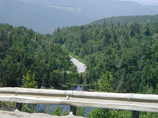
Once at the top, we relaxed with some much needed food and water. A quick break, and then we hit the descent. The memory of Bradley Evans was fresh in our mind, after his I-went-to-fast-into-this- corner-with-the-cliff fall from last year. Brad is missed, but we learned from his valuable lesson and we all took it easy without any crashes. Incidents, however, well, Forest did not disappoint, as he maintained his perfect record of severe mechanical problems on epic rides. A broken spoke and flat tire happened at the same time about 1/2 way down the dirt descent that goes over 30% grade. After Forest and I each grabbed the rim and cauterized the skin on our hands, we both exclaimed "gee, that rim sure is hot!" He had melted the glue on a patch and that was that.
The zippy ride down to 116 was uneventful if a hammer fest. We quickly approached the "baby gap" that is just a little soften-you-up climb before the real climbing starts. Wanting to keep a tight schedule, we didn't stop at the gas station near the top of the baby gap for water, thinking we could get some just over the top of Ap. We all stayed together until the base of Ap proper, and I took off for the town line about 100 yards up it. Feeling pretty fresh, I continued at a rapid clip right up the hill, taking only Forest with me. Having ridden the climb earlier (read: cooler) in the year, I felt I could do no wrong. Then the steep stuff hit. And the trees and shade went away. And the mercury inched up a few notches. And the breeze died down. Vivid imagery of "Mr. Bill Takes a Trip to Death Valley, starring Mr. Hand" filled my mind. A mere 10 minutes of climbing, however, and we all made it to the top. Well, all of us made it up that realized that 10 minutes was actually 20 minutes. And those of us who didn't flat. So some of us hung out for a while at the top of the steep stuff and lamented that we were all out of water. After the flat victims joined us, it was off on the descent (55 mph!) to the base of Ap and route 100. A long water/food stop ensued.
By this time, two members of our troupe had heat stroke and decided to pack it in and head for the stream/car. The rest of us could simply not resist the allure of Roxbury Gap: 5 miles of pure joy, 1/2 paved, 1/2 dirt. As we climbed through the tender hamlet of Warren Village, Forest and I spotted Dump Road, which we had come down on another trip. An excellent route modification and the four remaining riders were quickly in agony on this ultra steep dirt road. After grinding over this to the intersection where Roxbury Gap starts in earnest, it was clear that another 2 large bottles would be history by the top.
The climb starts out right away and remains an absolutely constant grade. The only thing that changes is the road surface. Remembering that it changes to dirt, back to pavement, and then back to dirt, Mark and Forest had the advantage. What we didn't quite recall is that it changes back and forth about 3 times. Heartbreak. I managed to scare some young children in a passing car with my facial expression on the way up. The rest of us suffered just the same in the brutal heat and direct sun -- no shade on this climb.
The drop down to 12a was no joy, as it was unpaved washboard hell. As our arms locked up and with our knuckles white, we came all the way down to the paved section and rolled right up to the Roxbury General Store for some more water/food. Then, for some reason, we all got pretty motivated and started hammering in a paceline over towards Rochester Mtn. Winding along the river valley at about 26 mph, we covered the 18 miles pretty quick. We did need another water/ food/dove bar stop at this point. I put my head in the ice cream freezer for about 10 minutes. We started off after some pure race food (Dove Bars) and then came to the base of...
"This one is really easy, although it does had a really short, short steep section at the very, very end." -- Forest Reid, June 10, 2001.
Well, I'll spare you the gruesome details of gradients and lengths, but the gradual 5 mile prelude to this merely breaks your will to live. It's the hellishly long and steep section with no shade or breeze at the end that puts the last nail in your coffin. We all agreed that this was deserving of official Gap status even though it does not typically rate among the popular gnarly climbs. I did manage to cool myself down quite a bit at the top as I started to shiver a bit (danger Will Robinson, danger) and then looked around and saw all of the snow-covered ski slopes. Uhhhh, right. Okay, mental note: drink some more electrolytes next time.
A raging no-brakes-required descent, and we hit route 100 like a ton of bricks. Although we all had grand ambitions of conquering six gaps, we were pretty much all done with 8 1/2 hours logged in the chamois. We could not even guess at the motivation of what we saw at the bottom, though: an old guy with racks and fenders riding along route 100 in 89 degree heat with 90% humidity wearing a parka and full tights. Maybe he had his a/c cranked in his house?
We rolled the few miles up to Hancock and of course Forest and I took each other on for the town lines. Although Forest took the "Welcome to Hancock" sign, it was I who took the official, legal town line sign. The official sign is the sign that denotes where the actual town line is, and what is used on maps, legal documents, and all deeds for the town. Forest and I bickered back and forth about which sign was worth more points, but I am sure that I am the victor of the real town line. Luckily, it was only about 1/4 mile back to the car, and Stefan managed to push me along the gentle grade.
As if by chance, there was a stream, restaurant, and general store all with 100 feet of where we parked the cars. Dinner was in order along with a lot of water drinking. Michele managed to order up some Venison Sausage to the delight of our server, who remarked "I don't like venison, but the sausage is OK." We all chowed down, took a bath in the stream, and milled about before it was up, up, and away back to our respective homes.
Trip time: 8.5 hours
Ride time: 6.5 hours
Victims: 6
Miles: 88
Climbing: 10,358 feet
Temp: 83-89 F
Humidity: 92%
Water: 5 refills of 2 large bottles = 10 x 28 oz = 280 oz
= 280 / 132 oz per gallon = 2.2 gallons (Mark)
Venison Sausages Consumed: 1
Times "Hot enough for ya?" Mentioned: 893
Knowing That You Did It: Priceless