La provincia de los Piros: native and Spaniard in early colonial south-central New Mexico
The site known today as Plaza Montoya Pueblo is located on the west side of the Rio Grande floodplain, a few kilometers south of Socorro, New Mexico. Once built entirely of adobe, very little of the pueblo remains today on the surface. Unimpressive though it may seem to the casual observer, the pueblo nonetheless is in much better shape than most other archaeological sites in the Piro area.
As Piro pueblos go, this is one of the largest known so far. The original estimate was about 200 ground-floor rooms, but after 5 seasons of excavation that figure is now up to about 250-300 rooms. Three of the pueblo's 4 room-blocks have yielded evidence of second-story construction, which means that ultimately the site may have had some 350-400 rooms total.
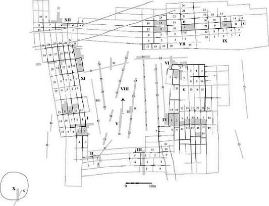 Plaza Montoya's layout comprises an almost fully enclosed main plaza, around which are grouped the 4 adobe room-blocks. An open eastern plaza was formed by a long eastern extension of the north room-block, and additional construction in the east room-block. Radiocarbon dates and diagnostic glaze-ware ceramics (belonging to three type complexes which archaeologists have separated on stylistic and stratigraphic grounds and labeled Glaze D, E, and F) indicate that Plaza Montoya was inhabited from the late 15th or early 16th century through the first half of the 17th century. Particularly interesting is the pueblo's occupation sequence after contact with the Spaniards in the late 16th century. Seventeenth-century documents tell us of declining native populations and disruptions of native settlement structures, processes that are also reflected in the archaeological records of many contemporary pueblos throughout New Mexico. A relevant pattern here is the decline of inhabited space per pueblo as indicated by the low ratio of historic (mainly E and F types) versus prehistoric (A through C/D) pottery. Precise absolute dates for these types are still debated, and there may be considerable temporal overlaps, but the general sequence of first appearances is well established.
Its size and a predominance of late glaze (primarily E) types on the surface suggested that Plaza Montoya might yield some new information on contact-period Piro population and settlement. Contrary to the prevailing regional pattern, we found late glaze ceramics in each of the pueblo's four room-blocks, as well as in the central plaza area, all of which pointed to an extensive post-contact occupation. With this, and with the possibility (based on contemporary documents) that a few settlements other than the 4 historically known mission pueblos may have been occupied well into the mid-1600s, work at Plaza Montoya began in June 2001. As the distribution of surface ceramics gave no hint of construction sequence and time depth, we decided early on to test as much of the pueblo as possible, and to try to outline the architectural history of each room-block.
In the following we will look at a few select areas that were excavated over the last 4 years. Each room-block will be introduced, as will be the central and east plaza areas. There will be a few room-block overviews, as well as some close-up looks at construction sequences and stratigraphies, especially in those places where we found metal and other non-native artifacts in situ. All this, however, presents only a small sample of the kind of information the site has yielded so far. Other topics, ranging from stylistic and petrographic analysis of diagnostic glaze-wares to faunal and floral analysis can only be touched upon in passing. All this will eventually be brought together in the form of a more comprehensive, more "traditional", treatise of both the site and the region at large.
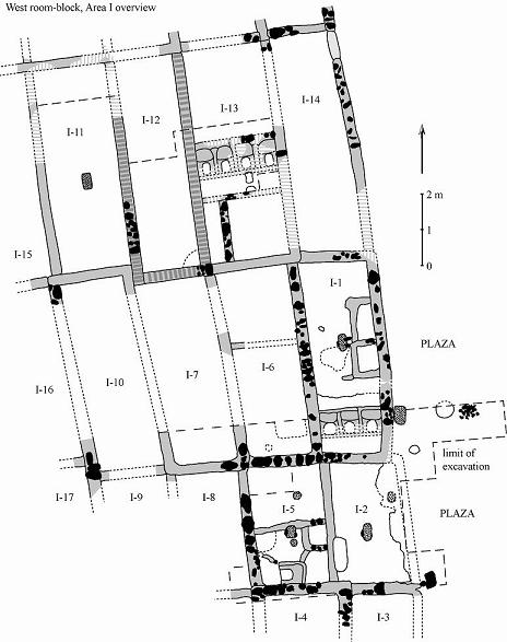
EXCAVATIONS IN THE WEST ROOM-BLOCK
The first 1x1m test units were placed in the central portion of the west room-block. This area was designated Area I; room numbers were assigned following the sequence of wall-scraping.
 TO BE CONTINUED
EXCAVATIONS IN THE EAST ROOM-BLOCK
Work in the east roomblock began in June 2001 with a line of sample units placed between the rooms labeled IV-1 and IV-14.
EXCAVATIONS IN THE NORTH ROOM-BLOCK
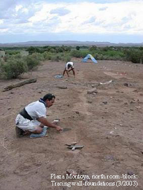 The north room-block, which is oriented east-west, measures some 80 to 90 m in length and 15 to 20 m in width. Estimated in ground-floor rooms it is about 15 to 20 rooms long and - at the widest spot - 7 to 8 rooms deep. The figures are approximations since the inner- and outermost rooms are on the whole not well preserved. In addition, the entire eastern third of the room-block was at one point subjected to grading and the installation of a drip system, as a result of which walls and features become increasingly invisible as one moves east and north toward the room-block's outer edge (which likewise cannot be clearly defined).
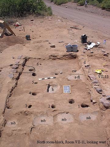
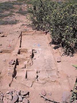
Overall, however, enough remains in the way of wall alignments to get a general idea of layout and construction sequence, especially in the room-block's central portion. Here the two adjoining Rooms VII-11 and VII-15 were completely and several others partly excavated. The photograph on the left (facing west) reveals the remains of three major construction/occupation phases in Room VII-11. Particularly conspicuous are the small circular to semi-circular holes in the lowermost surface, six of which (numbered 1 through 6) line up over a 90-degree corner. Most likely these six holes are from the posts of a ramada-like structure that was attached to Room VII-15 before VII-11 was built. No such holes were found in Room VII-15. More importantly, the cross walls of VII-11 abut VII-15. This indicates that the latter room was built first. As can be seen from the wall-bonding and abutment pattern shown in the floor plan on the right below (for Level 4, Floor 3; west is to the left!), Rooms VII-15, VII-16, and VII-23 formed part of the same early "core" room-block.
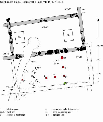
Of the features visible in the photo on the left, all those belonging to Level 4, Floor 3 are shown in the Room VII-11/15 floor plan. The possible post-holes 1 through 6 are in the plan filled in red and labeled p1, c1, p3, p5-6, and p8. Also part of the alignment may have been p4 (filled in green). The hole labeled c1 (#2 in the photo) turned out to be a bell-shaped pit, which contained a very thick, almost soot-like, concentration of ash and a large rim-sherd from a Glaze D/E redware bowl. We have already seen that several similar features in the east and west room-blocks contained cremation burials. The hole is therefore also addressed as a cremation, even though no larger bone fragments were found in the fill. But regardless of all this, c1 seems to have started out as a post-hole after all. Its upper wall was uniformly smooth and hard, just as one would expect when dirt is pushed against a wooden pole.
TO BE CONTINUED