|
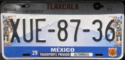
Placa gráfica de Tlaxcala
2006!
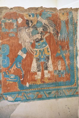
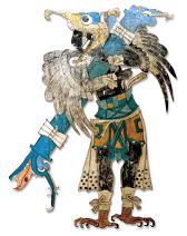
Números negros sobre gráfico reflejante. Fondo: al centro silueta del
volcán extinto La Malinche; a los extremos las imagenes original
y en espejo del Hombre-Ave (original,
restaurado), figura pintada hace alrededor de mil
años en Cacaxtla. Abajo: franja azul, der.- escudo del estado en
colores reales.
Sólo los números están realzados. Estas placas están en las
calles desde abril 2006. 2006 Graphic plate of
Tlaxcala! Black numbers over reflecting graphic. Background: at
center the outline of La Malinche extint volcano; at the extremes
the original and mirrored images of the Bird-Man (original,
restored), painting done
about one thousand years ago in Cacaxtla. Bottom: blue ribbon, right - state
seal in real colors. Only numbers are embossed. This
plates are on the streets since April 2006.
|
 |
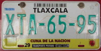
2002 - 2005.
Números verdes sobre blanco reflejante. Fondo: izq. a der. - torre de iglesia,
plaza de toros, silueta del volcán La Malinche, silueta de Xicoténcatl (rey
tlaxcalteca a la llegada de los españoles). Abajo: franja amarilla, centro -
eslogan Cuna de la Nación (ahí empezó el mestizaje), der.- escudo del estado.
Sólo los números están realzados. 2002
- 2005.
Green numbers over reflecting white. Background: left to right - church tower,
bullring, outline of La Malinche volcano, outline of Xicoténcatl (Tlaxcaltec
king when the Spaniards arrived). Bottom: yellow ribbon, center - slogan Cuna de
la Nación, Cradle of the Nation (there started the mestization), right - state
seal. Only numbers are embossed.
|
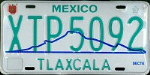 |
1999 -
2001. Verde sobre blanco reflejante. Arriba: izquierda - escudo
del estado. Fondo: silueta de la montaña La Malinche en azul.
Nombre y números realzados. Foto cortesía de Jim Moini.
1999 - 2001. Green on reflecting white. Top: left - state seal.
Background: outline of La Malinche mountain in blue.
Name and numbers embossed. Picture courtesy of Jim Moini. |
 |
1992 -
1998. Verde sobre blanco reflejante. Ultimo diseño general usado
durante 7 años. 1992
- 1998. Green
on reflecting white. Last general design used during 7 years.
|

TLAXCALA
© 2006 Raúl Conde
[email protected]
|