| Date |
Record |
Location |
Notes |
| May 2007 |
5.2�C |
St. John's UaDK |
It was the coldest month of May on record. The temperature did not rise above 10�C on 19 days during the month and eight days set new coldest daytime high records. The daily mean temperature was a chilly 5.2�C, over a full degree colder than the average mean of 6.5�C (set over seven years from 2000-2006). |
| 20 May 2007 |
11.7�C |
St. John's UaDK |
Finally, a warm record has been set. The overnight low only slipped to 11.7�C, which was the warmest overnight low ever recorded in the month of May going back to 2000. The high of 20.4�C was also a new warm record for May 20. However, despite this sudden warm weather, the month of May 2007 is still on track to be the coldest May on record, keeping in line with previous months so far this year. |
| April 2007 |
3.3�C |
St. John's UaDK |
Another cold weather record. Thanks to a cold north-easterly flow, the month of April was the coldest April recorded at the weather station. Only averaging 3.3�C this month, the temperature was a full 3.1�C below the average daytime high for the month of 6.4�C. |
| February 2007 |
-2.5�C |
St. John's UaDK |
After a fairly mild January, February turned much colder. It was the coldest month of February on record, a full 2.1�C below the normal February daytime average of -0.4�C. The temperature did not rise above 0�C for 283 consecutive hours between the 4th and 15th of the month. |
| August 2006 |
19.6�C |
St. John's UaDK |
After an early start to summer, the weather station recorded it's coolest August ever. The previous coolest August was in 2005 when the daytime highs averaged 21.4�C. This year, the daytime highs averaged a sad 19.6�C over the whole month, almost two degrees colder than last year. |
| June 2006 |
19.0�C |
St. John's UaDK |
It was the warmest month of June ever recorded at the weather station. The previous warmest June was in 2000 when the daytime highs averaged 17.7�C. This year, the daytime highs averaged a wonderful 19.0�C over the thirty days. |
| 24 June 2006 |
16.9�C |
St. John's UaDK |
A southwesterly flow did not allow the overnight low to drop below 16.9�C which made it the warmest overnight low ever observed in June since records began in 2000. However, by 23:59 NDT, the temperature had fallen to 16.1�C, and thus 16.9�C was not the official low temperature for the day. It was 11�C warmer than the average low temperature. |
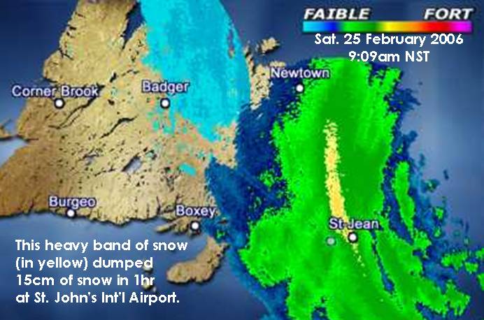
| 25 Feb. 2006 |
50-60cm
snow |
St. John's |
An intense low pressure system tracked further west than forecasted bringing intense snow and violent winds to much of eastern Newfoundland. Snowfall totals were close to 60cm and wind gusts were that of hurricane strength. The 57.9cm of snow that fell at St. John's UaDK was a record for a one-day snowfall. The 54.0cm that fell at the airport was 14cm shy of breaking the record set in April 1999. Click here for a snowfall comparison chart and here for a RADAR image of when the heaviest bands of snow passed over the northeast Avalon peninsula. |
| 16 Jan. 2006 |
10.4�C |
St. John's UaDK |
The same cold front did not reach the Avalon peninsula until 23:30. This kept St. John's in the warm sector of the low and the strong south-westerly winds kept the the temperature above 10�C overnight, only falling to 9�C at after 09:00. The overnight low temperature was 20�C above the normal low of -10�C. By 23:59, the temperature had fallen to 5.1�C and thus the 10.4�C was not the official low temperature for the day. |
| 15 Jan. 2006 |
15.0�C |
St. John's UaDK |
This same weather system resulted in a high of 15.0�C, making it the warmest January day since records began in 2000. The high temperature was 15�C above the normal high of 0�C. |
| 15 Jan. 2006 |
15.7�C |
St. John's Airport (YYT) |
Ahead of a sharp cold front, strong south-westerly winds helped to push a warm, tropical air mass ahead of the front. This resulted in a high of 15.7�C, making it the warmest January day since records began in 1942, beating the old record of 15.2�C set on 09 January 1979. |
| 08 Oct. 2005 |
16.8�C |
St. John's UaDK |
The overnight low dropped to 16.8�C making it the warmest overnight low temperature for October since records began in 2000. However the temperature plummeted to 6.6�C by 23:59 NDT and hence was not the official low for the day. |
| 02 Sep. 2005 |
19.5�C |
St. John's UaDK |
The overnight low dropped to 19.5�C making it the warmest overnight low of 2005 and the second warmest low temperature since records began in 2000. However the temperature fell to 17.5�C by 23:59 NDT and hence was not the official low for the day. |
| 23-26 Aug. 2005 |
130.0mm rain |
St. John's UaDK |
After a very dry month of August where only 23.1mm of rain fell in the first 22 days of the month, four days of heavy rain resulted in a deluge of 130.0mm. August 24 saw 55.6mm fall which was a record for the day and month for a one day rainfall total. |

