
It was late in July 2002 when I found myself looking forward to leaving Maui to travel to a reunion of my in-law's family. What? You say! Yes, I had ulterior motives. A few things came together to make this a truly exciting trip.
Over the previous few months I had been collecting / purchasing / borrowing backpacking gear in preparation for a trip planned for September. Along the way, as a byproduct of my on-line catalog shopping, I subscribed to a Trails.com newsletter. This service sends out teasers describing popular hiking, biking and skiing trails around the country, with the offer to sell a more complete description of the trail. Sometime in June, the newsletter featured hikes in the Pacific Northwest, showing beautiful pictures and enticing narrative about hikes in the cascade chain. Next, Ann's cousin planned a trip to attend a wedding in the Portland/Seattle area. Another cousin who lives in Portland agreed to host a 'reunion' and the plot was launched. Back to trails.com, I did a search of backpacking opportunities in the Portland area. I learned that there were many opportunities nearby Portland in the Mt. Hood Wilderness area. In fact, a trail claimed to be one of the most beautiful in the cascades is the Timberline Trail which circles Mt. Hood, roughly at the Timberline. As soon as I read the trail description, I knew that I wanted to hike this trail. The photos on the web showed pictures of snowy mountain peaks, brilliantly colored fields of wildflowers, flowing streams, cascading waterfalls and towering trees. Wow! I was hooked!
So next, I started researching the trail, reading all of the write-ups
available on the web. The basic Timberline trail is about 41 miles. There
are a number of opportunities for interesting side trips from the trail.
Guide books and other write ups suggested between a 3 and 6 day trip.
I planned a 4 day trip, and picked out three campsites and a side trip that
would give me average of 11 mile per day. (I figured that I would be pressing
my luck with Ann to spend more time on the trail). The variety of equipment
that I ordered started arriving in the mail, and I was able to borrow a tent
from Mark. When we found cheap air fare to Vancouver, the trip was on.
Soon some threatening clouds began to appear on the horizon. One trail narrative
that I read said that parts of the Timberline Trail would be covered with
snow until the Fall. These snow fields can be steep, and potentially dangerous
to cross as a slip could be fatal. The author warned that one should carry
an ice ax, and know how to use it. That was the first warning that I ignored
consciously, (but that my subconscious would nag me about later). The Park
Service also maintains a web page that describes the status of various trails
in the Wilderness, including the segments of the Timberline Trail. Indeed,
a week before we were to leave Maui, all segments of the trail were described
as having snow, and most segments of the trail were described as having
trees down. One section of the trail was describes as being in very bad
shape due to a recent mud slide. (an alternate routing was suggested). A
toll free Mt. Hood information number was listed, so I gave them a call.
"I am interested in learning about hiking the Timberline trail" I said.
"Well, you know the trail is closed", she said. "What?". You see, we had
an unusually large snowfall this winter, and a lot of the trail is still
covered with snow. Also, the trail maintenance crew has been busy fighting
forest fires, so there are a lot of trees down on the trail, and the bridges
are not in yet. So, the trail will probably stay closed until mid-September.
When were you planning to come out?", she said. "I will be there next week",
I said, "what does it mean that the trail is closed?". "Well, it is your
mountain, so you can do as you please, but the trail is closed. Why don't
you stop by before going to the mountain and review the latest reports."
"Great, I'll do that, thanks for your help", I said. "Oh shit" I thought.
This was the second warning that my conscious ignored, and my subconscious
tucked away for future nagging potential. So, before leaving Maui, I went
back to Trails.com and printed some info about other trails in the area as
a backup plan. Online info told that the Wonderland trail around Mt. Rainier
was in better shape. This is a longer trek, however, and I would not be
able to get all the way around. 
Armed with my pack full of mostly new equipment, untried meals, a subconscious
full of warnings (and the addresses of REI and the Mt. Hood info center)
, we set out for Portland and th e family reunion. Flying into Vancouver BC afforded a nice view of
the coast and the great expanses of forest land in the northwest, giving
me a taste of what I might see on the trail. One of our first stops was
the REI store in Portland. What an amazing selection. There I talked with
someone who had been on Mt. Hood a few weeks ago, and he told me that where
I might run into trouble. "The trail is pretty rough now", he said, "you
better give yourself an extra day to get around. It may be difficult to
find the trail in spots, use your compass and follow the contours". "An
ice ax would not be needed", he said, unless the night was very cold, the
snow fields would be soft enough to be able to dig in the side of a boot.
He pointed me to the right maps, and I bought fuel and a meal. I also made
a major find in a pair of used Vasque Zephyr hiking boots for $9.39! The
original owner complained that they leaked. To me, they were in new condition,
and quite a bargain as they sell for $145 new. I wore them to the family
reunion to break them in.
e family reunion. Flying into Vancouver BC afforded a nice view of
the coast and the great expanses of forest land in the northwest, giving
me a taste of what I might see on the trail. One of our first stops was
the REI store in Portland. What an amazing selection. There I talked with
someone who had been on Mt. Hood a few weeks ago, and he told me that where
I might run into trouble. "The trail is pretty rough now", he said, "you
better give yourself an extra day to get around. It may be difficult to
find the trail in spots, use your compass and follow the contours". "An
ice ax would not be needed", he said, unless the night was very cold, the
snow fields would be soft enough to be able to dig in the side of a boot.
He pointed me to the right maps, and I bought fuel and a meal. I also made
a major find in a pair of used Vasque Zephyr hiking boots for $9.39! The
original owner complained that they leaked. To me, they were in new condition,
and quite a bargain as they sell for $145 new. I wore them to the family
reunion to break them in.
I made a copy of my maps, listed each of my intended campsites and itinerary, and gave this along with phone numbers of the rangers station and visitor's centers to Ann. My plan was to be back at Timberline Lodge on Thursday afternoon for Ann to pick me up at 3:00. Ann is always early, and expected her to be doubly so for this pickup, so my goal would be to get to the lodge plenty early. I also planned to carry a cell phone, although I didn't know if it would work on the trail.
The next day, the three Hammond cousins drove me to Mt. Hood. As we got
close, the weather turned really ugly with thick clouds, fog and intermittent
rain. As we got closer, however, the clouds burned off, the sky turned blue,
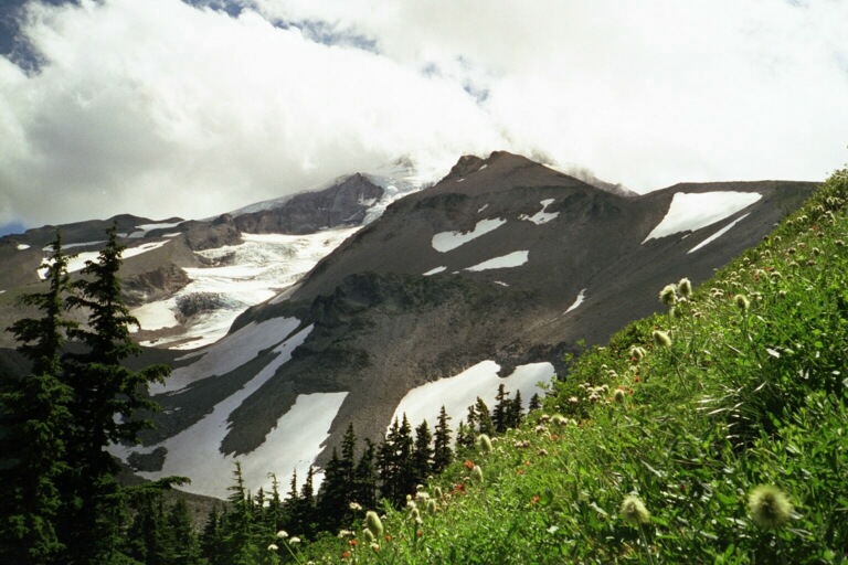
and Mt. Hood appeared in view. Indeed, it was covered in snow! (Oh no.)
Before going up the mountain, we stopped at the info center. While I used
the bathroom, Ann and cousin's went to the info desk. When I got there, Ann
and KR were shaking their heads, "It doesn't look good" they said. The rangers
confirmed that the trail was closed, and as far as they knew, no one had
made it around the mountain yet this season. The heavy snows covered the
trails, and a group got lost their last week. Also, in one place, about ½
way around, there was a snow ledge that presented a sheer cliff along the
trail that could not be crossed. They made some calls to see if anyone knew
more, and suggested taking a few wimpy day hikes. This  didn't do much to quell my subconscious, but by now I was getting
pretty good at ignoring warning, so off we went ut the mountain. I figured
that I would go as far as I could, and if I got stuck I would turn back,
or hike out on one of the side trails. I carried a cell phone, so eventually
I would get picked up. There are a couple of places to hop on the Timberline
trail. The one that I chose was Timberline lodge, which is a neat WPA built
ski lodge made of huge timbers. There were several more park rangers on
duty in the lodge, standing near a map of the Mt. Hood wilderness. I told
them I was interested in hiking the Timberline trail, and asked if they
knew anything about trail conditions. They mostly knew about the lodge,
and handed me a brochure about the trail, but no new info. One ranger standing
in the background, who looked like she actually spent some time out of doors,
overheard our conversation and looked at me and said "you'll have fun".
I think that this is as close to a go ahead as the Park Services liability
avoidance guidelines allow. Ann took all of this in, and with a measure
of trepidation wished me a safe journey as I put on my 40 lb. pack and started
west down the Timberline trail at 11:00 on Monday.
didn't do much to quell my subconscious, but by now I was getting
pretty good at ignoring warning, so off we went ut the mountain. I figured
that I would go as far as I could, and if I got stuck I would turn back,
or hike out on one of the side trails. I carried a cell phone, so eventually
I would get picked up. There are a couple of places to hop on the Timberline
trail. The one that I chose was Timberline lodge, which is a neat WPA built
ski lodge made of huge timbers. There were several more park rangers on
duty in the lodge, standing near a map of the Mt. Hood wilderness. I told
them I was interested in hiking the Timberline trail, and asked if they
knew anything about trail conditions. They mostly knew about the lodge,
and handed me a brochure about the trail, but no new info. One ranger standing
in the background, who looked like she actually spent some time out of doors,
overheard our conversation and looked at me and said "you'll have fun".
I think that this is as close to a go ahead as the Park Services liability
avoidance guidelines allow. Ann took all of this in, and with a measure
of trepidation wished me a safe journey as I put on my 40 lb. pack and started
west down the Timberline trail at 11:00 on Monday.
There are are several places along the trail where one can start. I chose
to start at the Timberline Lodge (which is easily accesible) and to hike
clockwise (which appears to be the most popular choice). There were a number
of day hikers on the trail near the lodge. Many of them were frequent visitors
along this trail, and good sources of information (they also made sure that
my nagging fears did not stop nagging). One couple told me that they had
hiked the south portion of the trail the last weekend, and there were a lot
of dangerous snow fields. The snow lingers in the runs and creates a slippery
slope that often ends either in big craggy rocks, or a cliff. I asked the
next guy that I met if there was any special technique involved in crossing
the snow fields. "Plant your poles" he told me, " and dig in with the edges
of your boots". This technique (along w ith going very slow) worked well for me. My heart rate still rose
every time I saw a big snow field, but I never slipped. (Well, at least
never fell) While the snow was deep and compacted in these runs, the weather
had been warm enough so that the surface was melting leaving a top layer
of soft crusty snow and ice that was easy to cut into with the edge of a
boot.
ith going very slow) worked well for me. My heart rate still rose
every time I saw a big snow field, but I never slipped. (Well, at least
never fell) While the snow was deep and compacted in these runs, the weather
had been warm enough so that the surface was melting leaving a top layer
of soft crusty snow and ice that was easy to cut into with the edge of a
boot.
The first day's hike went very well. My new Dana Designs Glacier pack
fit me well. I tried various combinations of strap adjustments, and found
one that worked well for me. This was also the first time hiking with two
hiking poles. These took a bit of getting used to, but once I got the
technique down, I found them to be very helpful, especially on both the
climbs and descents. For me, one of the tricks was to get the straps adjusted
correctly so that my wrist or palm would be supported by the strap so that
it was not necessary to grip the pole handle in order to gain support from
it. I found no use for the 'anti-shock' feature. The trail was in very
good condition, and as it was mostly downhill, I was able to make pretty good
time. I took the Paradise Park Loop, and in this area was treated to my
first views of the Cascades wildflowers. It is hard to describe the variety
and brilliance of the colors of the flowers that were in bloom. Many places
on the trail would open up into meadows that were covered with flowers of
all descriptions. After Paradise loop, the trail descended steadily on
the south side of Zigzag Canyon throug h mostly densely forested areas. By 4:30 I arrived at the Sandy River
crossing. This was my first major stream crossing, and the water was running
pretty strong. This is the spot that I intended to camp for the night, and
indeed I found a beautiful spot that was described in the trail book along
the Rushing Waters stream which joined Sandy River just west of the trail.
(According to the permit, one must camp at least 100 feet from the water,
so this site is not technically a legal one). Since it was still early,
I started looking for a dry stream crossing, and couldn't find one, so I
set up camp. Occasionally I would hear rocks in the stream roll down with
a deep 'thud' as the rushing waters pushed them along. I was not looking
forward to having one of those rocks hit my ankle! This portion of the Timberline
trail is also the Pacific Crest Trail which is also a horse trail. About
5:00 3 girls on horseback crossed the stream from the opposite direction to
my travel, about 30 minutes later they were back, and re-crossed. At about
6:00 a couple backpacking came by. One of them discovered two trees that
were across the stream, and with a delicate balance were able to get across
dry. Why didn't I see that??? Oh well, ... I had a relaxing evening.
Dinner was fair, ... Too much raw garlic which did not sit well with me that
night. Since I didn't have much experience with my stove or fuel, I conserved
it too aggressively. Most of my meals were undercooked, which was not good
for either their taste, or for my digestion. That night I slept in my tent,
but without the tarp. I had a hard time calming down, with my heart beating
quick and strong well into the night. I think that this was due to a combination
of excitement and fear. Even though the day went well, I was still afraid
of what was ahead.
h mostly densely forested areas. By 4:30 I arrived at the Sandy River
crossing. This was my first major stream crossing, and the water was running
pretty strong. This is the spot that I intended to camp for the night, and
indeed I found a beautiful spot that was described in the trail book along
the Rushing Waters stream which joined Sandy River just west of the trail.
(According to the permit, one must camp at least 100 feet from the water,
so this site is not technically a legal one). Since it was still early,
I started looking for a dry stream crossing, and couldn't find one, so I
set up camp. Occasionally I would hear rocks in the stream roll down with
a deep 'thud' as the rushing waters pushed them along. I was not looking
forward to having one of those rocks hit my ankle! This portion of the Timberline
trail is also the Pacific Crest Trail which is also a horse trail. About
5:00 3 girls on horseback crossed the stream from the opposite direction to
my travel, about 30 minutes later they were back, and re-crossed. At about
6:00 a couple backpacking came by. One of them discovered two trees that
were across the stream, and with a delicate balance were able to get across
dry. Why didn't I see that??? Oh well, ... I had a relaxing evening.
Dinner was fair, ... Too much raw garlic which did not sit well with me that
night. Since I didn't have much experience with my stove or fuel, I conserved
it too aggressively. Most of my meals were undercooked, which was not good
for either their taste, or for my digestion. That night I slept in my tent,
but without the tarp. I had a hard time calming down, with my heart beating
quick and strong well into the night. I think that this was due to a combination
of excitement and fear. Even though the day went well, I was still afraid
of what was ahead.
On Thursday I awoke at 5:45, ..., I can almost never sleep through first
light. I fixed a meal of  oatmeal and tea, broke camp and was on the trail by 7:00. After only
0.5miles I came to Ramona Falls. This is a very beautiful spot, which also
sports a large campsite. The falls are very broad, and form a picturesque
cascade over the rocks. The stream below was not wide or deep while I was
there, but after a rain or melt, could be difficult to cross. The forest
service was building a bridge out of a huge fallen tree. At Ramona Falls
I had a decision to make. The Timberline trail from here heads northeast,
up the muddy fork stream valley. However, there were notices on the park
service web page saying that this part of the trail was in bad shape due
to a recent mud flow. The trail was passable on foot, but was washed out
in many spots so caution was urged. Notices posted on the trail said that
this section of the trail had become impossible to maintain due to erosion,
so was being rerouted to the west. I let my fear get the best of me and decided
to take the 'safe' route, which followed trail 794 to the west, then 784
to the north where it met the Timberline trail again near Bald Mountain.
Trail 794 descended steadily, down, down, endlessly down, along a nice babbling
brook through a heavily forested area. The view of the mossy stream, fern
laden valley and adjacent rocky cliffs was enchanting. But I kept g
oatmeal and tea, broke camp and was on the trail by 7:00. After only
0.5miles I came to Ramona Falls. This is a very beautiful spot, which also
sports a large campsite. The falls are very broad, and form a picturesque
cascade over the rocks. The stream below was not wide or deep while I was
there, but after a rain or melt, could be difficult to cross. The forest
service was building a bridge out of a huge fallen tree. At Ramona Falls
I had a decision to make. The Timberline trail from here heads northeast,
up the muddy fork stream valley. However, there were notices on the park
service web page saying that this part of the trail was in bad shape due
to a recent mud flow. The trail was passable on foot, but was washed out
in many spots so caution was urged. Notices posted on the trail said that
this section of the trail had become impossible to maintain due to erosion,
so was being rerouted to the west. I let my fear get the best of me and decided
to take the 'safe' route, which followed trail 794 to the west, then 784
to the north where it met the Timberline trail again near Bald Mountain.
Trail 794 descended steadily, down, down, endlessly down, along a nice babbling
brook through a heavily forested area. The view of the mossy stream, fern
laden valley and adjacent rocky cliffs was enchanting. But I kept g oing down, and began thinking about the climb out. The intersection
of 794 and 784 was the lowest part of the trail, at 2800'. I would not stay
at that elevation for long. Trail 784 was steep! With many, many switchbacks.
As you know, most of my equipment was new, and I was experimenting a bit.
Well, one particular experiment, where I was trying to learn which socks
I liked best, did not work out so well. I usually hike in a pair of cotton
'sports' socks. Well I read that it is better to wear heavier socks, made
of something besides cotton that would help wick the water away from your
feet. So, I purchased two different types of hiking socks; Trekers from
Bridgdale of Ireland, and Trekers from Rohner of Switzerland. I wore the
Rohners the first day (sweet) and the Bridgedales the second (mistake).
My 'normal' shoe size is a 12. Ideally I would wear size 12 ½ boots,
to allow for sock room, but alas most hiking boots do not come in half sizes
once you cross the 'bigfoot' threshold (particularly not for $9.39) so I
was wearing size 13's. Going uphill, my heel was moving around more than
it should. Even though I knew to stop and 'do something' at the first sign
of a hot spot, I pushed on, climbing and cl
oing down, and began thinking about the climb out. The intersection
of 794 and 784 was the lowest part of the trail, at 2800'. I would not stay
at that elevation for long. Trail 784 was steep! With many, many switchbacks.
As you know, most of my equipment was new, and I was experimenting a bit.
Well, one particular experiment, where I was trying to learn which socks
I liked best, did not work out so well. I usually hike in a pair of cotton
'sports' socks. Well I read that it is better to wear heavier socks, made
of something besides cotton that would help wick the water away from your
feet. So, I purchased two different types of hiking socks; Trekers from
Bridgdale of Ireland, and Trekers from Rohner of Switzerland. I wore the
Rohners the first day (sweet) and the Bridgedales the second (mistake).
My 'normal' shoe size is a 12. Ideally I would wear size 12 ½ boots,
to allow for sock room, but alas most hiking boots do not come in half sizes
once you cross the 'bigfoot' threshold (particularly not for $9.39) so I
was wearing size 13's. Going uphill, my heel was moving around more than
it should. Even though I knew to stop and 'do something' at the first sign
of a hot spot, I pushed on, climbing and cl imbing. The trail was in good shape, with a few trees down and some
exposed roots, but nothing that slowed me down as much as the climb. A
trail crew was working this section of the trail, and I stopped and chatted.
They told me that a small group had backpacked the entire Timberline loop
a week ago. Yes! This was the first good news that I had heard! At this point,
I was confident that if I didn't slip and slide down an ice field, or drawn
in a stream crossing, or get eaten by a cougar, that I would probably complete
the trip! These guys had some nice trail building equipment. They were
using a small treaded backhoe that one would walk behind as well as a power
circular saw. At the top of trail 784, I rejoined the PCT, at elevation
4100' where the trail forms a loop around Bald Mountain. There is a beautiful
view from here down a wildflower covered slope to the valleys and distant
peaks to the south. Here I stopped to eat lunch and survey the 'hot spots'
on my heels. I learned that what I was feeling may have been 'hot spots'
at one time, but were now full blown blisters, one on each heel. My feet
were also pretty wet, ... So much for my wicking Bridgedales. On the up
side, I got practice in cutting and placing moleskin. A technique that worked
well for me was to pad the area around the blister by cutting a circle in
the moleskin, then filling the 'hole' with neosporin. This disinfected, and
lubricated the blister. From then on, I wore two pair of socks. (much better)
and tightened my boot laces (mistake). Later that day, when retying my boots,
I felt a sharp pain in my right shin bone. It seems that I tightened my
boot so much that when I flexed my foot it broosed my leg. This hurt more
than the blisters! What is important is that the bottom of the boots are
laced tightly. My boots have a 'clasp' at the bottom section which aids this.
Once I got this dialed in, I did much better. It was this stop where I
left my bandana. I asked other hikers if they found it, one said that they
left it assuming the owner was doing the Bald Mountain Loop. At Bald mountain
I came upon a guide who was showing a couple around. I would pass and be
passed by them several times through the afternoon. She told me of a short-cut
on the east side of Bald Mountain which connects back to the Timberline trail,
allowing me to enjoy the view, without retracing my path. Later that day
the weather started to look threatening. The winds came up and dark clouds
started streaking across the sky. The weather was coming from the East,
over the mountain from my location, so I could not tell what was in store.
The weather forecast was for dry conditions through the week, so I was
only mildly concerned. I knew, however, that if these conditions persisted
on the day that I was to cross the high exposed Lamberton Butte on the East
side of Mt. Hood, that I would not be so comfortable. Of course I remembered
the story that my cousin told me of being barely able to stand in the parking
lot one time during a wind storm.
imbing. The trail was in good shape, with a few trees down and some
exposed roots, but nothing that slowed me down as much as the climb. A
trail crew was working this section of the trail, and I stopped and chatted.
They told me that a small group had backpacked the entire Timberline loop
a week ago. Yes! This was the first good news that I had heard! At this point,
I was confident that if I didn't slip and slide down an ice field, or drawn
in a stream crossing, or get eaten by a cougar, that I would probably complete
the trip! These guys had some nice trail building equipment. They were
using a small treaded backhoe that one would walk behind as well as a power
circular saw. At the top of trail 784, I rejoined the PCT, at elevation
4100' where the trail forms a loop around Bald Mountain. There is a beautiful
view from here down a wildflower covered slope to the valleys and distant
peaks to the south. Here I stopped to eat lunch and survey the 'hot spots'
on my heels. I learned that what I was feeling may have been 'hot spots'
at one time, but were now full blown blisters, one on each heel. My feet
were also pretty wet, ... So much for my wicking Bridgedales. On the up
side, I got practice in cutting and placing moleskin. A technique that worked
well for me was to pad the area around the blister by cutting a circle in
the moleskin, then filling the 'hole' with neosporin. This disinfected, and
lubricated the blister. From then on, I wore two pair of socks. (much better)
and tightened my boot laces (mistake). Later that day, when retying my boots,
I felt a sharp pain in my right shin bone. It seems that I tightened my
boot so much that when I flexed my foot it broosed my leg. This hurt more
than the blisters! What is important is that the bottom of the boots are
laced tightly. My boots have a 'clasp' at the bottom section which aids this.
Once I got this dialed in, I did much better. It was this stop where I
left my bandana. I asked other hikers if they found it, one said that they
left it assuming the owner was doing the Bald Mountain Loop. At Bald mountain
I came upon a guide who was showing a couple around. I would pass and be
passed by them several times through the afternoon. She told me of a short-cut
on the east side of Bald Mountain which connects back to the Timberline trail,
allowing me to enjoy the view, without retracing my path. Later that day
the weather started to look threatening. The winds came up and dark clouds
started streaking across the sky. The weather was coming from the East,
over the mountain from my location, so I could not tell what was in store.
The weather forecast was for dry conditions through the week, so I was
only mildly concerned. I knew, however, that if these conditions persisted
on the day that I was to cross the high exposed Lamberton Butte on the East
side of Mt. Hood, that I would not be so comfortable. Of course I remembered
the story that my cousin told me of being barely able to stand in the parking
lot one time during a wind storm.
Soon I would come to Cairn Basin, which was the spot the rangers told me
was not passable due to a snow/ice ledge. There were a few snowy patches,
but nothing dangerous here. The warm weather the week before must have
melted out a lot of snow. Based on information from another hiker, I decided
to take the east fork of the Eden Park loop. Ladd Creek crosses the trail
in this section, and was supposedly very wet in the western leg. There were
a lot of trees down across the trail just after Cairn basin. In some places
the trail went around these. These obstacles slowed the pace, but not drastically.
Then I came to the Ladd Creek crossing. The creek was flowing very strongly,
and there was no way I was going to get across dry where the trail crossing
was marked. One of the biggest mistakes I made in preparing for this trip
was to not bring water shoes. I had a pair of rubber slippers, but these
were not reliable enough in running water. Other hikers carried either Teva's
or neoprene booties. At Coe Creek I found a snow bridge just upstream.
A snow bridge forms when the streams freeze in the winter, and heavy snowfall
is compacted in the stream bed. When the stream begins to flow in the Spring,
the snow is washed a way in the stream bed, leaving a bridge of compacted snow above.
Of course these snow bridges are not permanent, hence they are going to
collapse sometime. I poked at this one with my hiking poles, crossed my
fingers, and scampered across with my heart pounding. Keep in mind that I
had never seen, no less crossed a snow bridge, and had not yet seen the poster
that I would read later that day that described the dangers of crossing snow
bridges. But my feet were dry! (at least temporarily). This did nothing
to calm my fears of stream crossing, however.
way in the stream bed, leaving a bridge of compacted snow above.
Of course these snow bridges are not permanent, hence they are going to
collapse sometime. I poked at this one with my hiking poles, crossed my
fingers, and scampered across with my heart pounding. Keep in mind that I
had never seen, no less crossed a snow bridge, and had not yet seen the poster
that I would read later that day that described the dangers of crossing snow
bridges. But my feet were dry! (at least temporarily). This did nothing
to calm my fears of stream crossing, however.
I arrived at my intended destination, Elk Cove, at 2:30. This was a spectacularly
beautiful spot, with huge evergreens framing a meadow. It was so early,
however, that I decided to push on. The next campsite was Cloud Cap, which
was still a good 5 miles away, but I figured that if need be, I would be
able to find a place to camp along the trail. After about 30 minutes, I
started hearing rushing water, which kept getting louder, and louder, until
the forest opened into a big bolder strewn valley cut by Coe Creek. The
Trail notes say that Coe is "bridged from Approx. Mid July to Sept." Normally
the forest service flies in bridges after the last big melt, and before the
snow comes. However, this season it had snowed late, and the forest service
was busy fighting wildfires, so the bridges were not in, ..., but the water
was still flowing. Coe is primarily glacier fed, so it contains a lot of
gray pumice/ash. This means that even if there were not white water, you
cannot see the bottom of the stream. How deep is it? I spent 45 minutes
walking upstream looking for a dry crossing. The dry part of the valley
was strew with boulders ranging to 20 feet in diameter, so most of this time
was spent hopping 2-3 foot boulders. At one point I lost my balance and
went down. This is when I learned that if I put all of my weight (plus backpack)
on my hiking stick, that it collapses! This action was a surprise, but did
cushion my fall somewhat. Luckily my only injury was a nasty bang on my
right elbow, (which stayed quite sore for more than a month). As I was
poking around looking for a place to cross, another hiker came from the other
direction. He took off his boots, put on his neoprene booties, and started
throwing rocks in the stream. Later, after he crossed, leaning against a
heavy wooden stick that was left by the trail, he told me to throw rocks
in to gauge the depth and plot your path. Then lean hard against the current,
and cross walking at an angle, toward upstream. By now, my feet were wet,
so while he watched (to give me some false sense of security) I crossed the
stream, wearing my boots, with water rushing about over my knees. Exciting!
This section of trail was the first part that was significantly overgrown,
but still easy to follow. After Coe the trail became very rocky, with a
lot of trees down, and many spots washed out. Near Compass Creek Crossing
there were views of water falls in Compass Creek in the distance, as well
as long views down the mountain. At Compass I stopped and changed socks,
hanging my wet sock on the outside of my pack. By now the wind was really
howling overhead, and was getting a bit cool. I was still OK in just a short
and shorts, as I was still expending a lot of energy. As it turned out,
I was probably not drinking quite enough, and ended up making another 'mistake'.
At about 4:30, just after crossing the first of three branches of Compass
Creek there was a nice campsite in the trees. This campsite is at the base
of a climbing route that goes up Coe Glacier to Pulpit Rock. I was feeling
pretty tired by now, and a bit sore, bit since there was still another 3
hours to dark, I figured I would p ress on and get to Cloud Cap. This would put me on the bank of Eliot
Creek, which I knew to be another big stream. I would then cross it first
thing in the morning when it was running slower. .... Wrong .... At just
past 6:00, my feet were sore, and I was tired, when I was expecting to see
the sign for the trail to Cloud Cap campground, when instead I see a sign
describing a washout at the Elliot Creek Crossing, and pointing to a 1.5
mile detour with an alternate crossing of Elliot Creek. Cloud Cap Campground
was on the other side of Elliot Creek! How could I have misread the map
so badly??? There was not a lot I could do at that point but to push on.
The detour was steep! (my heels did not appreciate that) and the crossing
was wet, and the far side detour not so well marked, ... But it got me to
the campground at 7:00. Cloud Cap is one of the 'improved' campsites on
the trail, and is accessible by car. It was equipped with water, composting
toilet (which I made ample use of) and fire rings. Still, it was not so
crowded. There were a couple of day hikers that went through, and one other
camper who had driven in. The wind was really howling now. As we were
in the lee of the mountain, it was not so bad in the campsite, but still it
got cold and noisy. I was comfortable with my fleece, rain jacket, headband
and long pants. If I had been wet, I would have been very uncomfortable.
I had a quick Mountain House meal (yuck!), did some laundry, and hung my wet
things. I was able to get a cell connection from the camp, and talked to
Annie. That evening I enjoyed a beautiful sunset over the distant peak of
??? I got to bed at 9:00, but did not sleep well. My stomach was bothering
me, as were my heels. The howling of the wind made me anxious about the
next day's hike. This was my longest hiking day. In 12 hours, I traveled
18 miles.
ress on and get to Cloud Cap. This would put me on the bank of Eliot
Creek, which I knew to be another big stream. I would then cross it first
thing in the morning when it was running slower. .... Wrong .... At just
past 6:00, my feet were sore, and I was tired, when I was expecting to see
the sign for the trail to Cloud Cap campground, when instead I see a sign
describing a washout at the Elliot Creek Crossing, and pointing to a 1.5
mile detour with an alternate crossing of Elliot Creek. Cloud Cap Campground
was on the other side of Elliot Creek! How could I have misread the map
so badly??? There was not a lot I could do at that point but to push on.
The detour was steep! (my heels did not appreciate that) and the crossing
was wet, and the far side detour not so well marked, ... But it got me to
the campground at 7:00. Cloud Cap is one of the 'improved' campsites on
the trail, and is accessible by car. It was equipped with water, composting
toilet (which I made ample use of) and fire rings. Still, it was not so
crowded. There were a couple of day hikers that went through, and one other
camper who had driven in. The wind was really howling now. As we were
in the lee of the mountain, it was not so bad in the campsite, but still it
got cold and noisy. I was comfortable with my fleece, rain jacket, headband
and long pants. If I had been wet, I would have been very uncomfortable.
I had a quick Mountain House meal (yuck!), did some laundry, and hung my wet
things. I was able to get a cell connection from the camp, and talked to
Annie. That evening I enjoyed a beautiful sunset over the distant peak of
??? I got to bed at 9:00, but did not sleep well. My stomach was bothering
me, as were my heels. The howling of the wind made me anxious about the
next day's hike. This was my longest hiking day. In 12 hours, I traveled
18 miles.
The next morning I woke at 6:00AM to clear skies with the winds subsiding!
As I was ahead of schedule, I took time to start a fire to dry out my socks
and shoes, spending most of the morning in camp, drying out, eating, and
warming around the fire. What a treat! I got going on the trail at about
10:45 after a brief visit by a deer in camp. Cloud Camp is at about 5600
ft elevation. The next section of trail crosses the highest portion of the
Timberline trail at 7300 ft, so I knew I had a climb ahead of me. This section
was also described as 'more a route than a trail', and 'one that requires
a map and compass, and knowledge of how to use them'. AS it turns out, this
section of trail climbs well above the timberline, on mostly exposed rock.
If there had been much snow on the trail, it would have been quite difficult
to follow. However, it was mostly clear, so I had no trouble. To aid one
in finding the trail, particularly in the snow, there are huge cairns placed
along the trail made of piles of rocks about 3 feet high, each supporting
a tall thick wooden post that extends about 8 feet in the air. These are
pretty hard to miss. The views were great along this section with dry,
clear air, and the trail ab ove the trees. The trail was mostly loose rock and sand in this area,
which was not as friendly as the compressed cinders on the west sections
of trail. Finally I got the hang of crossing the snow fields, which were
large and frequent on this section of trail. Slow and careful! This was
also the 'driest' section of the trail, with no pumpable water for an ~ 5
mile section. I drank a lot at Cloud Cap, and carried 2 liters, ... No problem.
ove the trees. The trail was mostly loose rock and sand in this area,
which was not as friendly as the compressed cinders on the west sections
of trail. Finally I got the hang of crossing the snow fields, which were
large and frequent on this section of trail. Slow and careful! This was
also the 'driest' section of the trail, with no pumpable water for an ~ 5
mile section. I drank a lot at Cloud Cap, and carried 2 liters, ... No problem.
My destination for Wednesday night was Elk Meadows. This is an area that
is about a mile off the trail, and down slope, but described by the trail
guides as well worth the side trip, with beautiful views and great campsites.
I got to the Gnarl Ridge trail, which leads to Elk Meadows, and started
down the hill. Soon I heard water gurgling, and noticed that I was a bit
thirsty. Also my water bottles were empty. Elk Meadows was close, however,
and I was sure that there would b e water there. Continuing on, I heard the gurgle of water again,
but could see no stream. Looking down, I could see that the surface that
I was walking on, and near, was actually porous, and the water was flowing
just below the surface, maybe 1 foot below. After all, this is a volcano,
and many places still have a very porous structure. Interesting. On the
Gnarl Ridge Trail, I passed a family of 4 on a day hike. They told me that
the Meadows were beautiful, and deserted! Great! Elk Meadows is circled
by a trail of 1.1mile. The permits and the guides say that you are not
allowed to camp in the islands of trees in the meadow, but instead must
camp in the surrounding trees. So, I got to the circle route, and started
around it looking for a campsite. Well, after I got about 1 and ¼
way around (the junction was overgrown) I was seriously doubting the trail
guides. The guide did talk about a dilapidated shelter, and I could see
one in the distance. Often dilapidated shelters mean trash and rats, so
I was not so attracted to that, but decided to see how to get to the shelter,
hoping that the campsites might be near there. Am I glad that I did! Nearby
the shelter was a perfect campsite sporting nearby water, and a view of the
meadow with Mt. Hood beyond. What a beautiful place! And I had it all to
myself. (sorta). Walking into the camp I saw a lot of animal prints on the
trail. Most of these were deer, but there were also a large variety of paw
prints. Were they dogs, bear or cougar? I didn't know. In the mud, beside
the stream where I pumped water there were a lot of small prints, and one
huge paw print. It was scary when I thought about it. The only wildlife
that I actually saw in camp were a few chipmunks, and some rather aggressive
birds that wanted to share breakfast with me. That night I had plenty
of time to cook, and fixed a pelenta stew. That night I learned that dried
peas are not at all the same as freeze-dried peas. Also, when a recipe calls
for a small amount of ground sunflower seed, a handful of whole seeds is
not a good substitute. So my meal was a bit crunchy. Onion and garlic
need to be cooked more. The tapioca turned out well, however, but needs
cinnamon. I have not been so hungry, possibly because my cooking has been
so bad. I have a lot of leftover food, maybe 2-3 pounds. Tea and oatmeal
in the morning has tasted very good.
e water there. Continuing on, I heard the gurgle of water again,
but could see no stream. Looking down, I could see that the surface that
I was walking on, and near, was actually porous, and the water was flowing
just below the surface, maybe 1 foot below. After all, this is a volcano,
and many places still have a very porous structure. Interesting. On the
Gnarl Ridge Trail, I passed a family of 4 on a day hike. They told me that
the Meadows were beautiful, and deserted! Great! Elk Meadows is circled
by a trail of 1.1mile. The permits and the guides say that you are not
allowed to camp in the islands of trees in the meadow, but instead must
camp in the surrounding trees. So, I got to the circle route, and started
around it looking for a campsite. Well, after I got about 1 and ¼
way around (the junction was overgrown) I was seriously doubting the trail
guides. The guide did talk about a dilapidated shelter, and I could see
one in the distance. Often dilapidated shelters mean trash and rats, so
I was not so attracted to that, but decided to see how to get to the shelter,
hoping that the campsites might be near there. Am I glad that I did! Nearby
the shelter was a perfect campsite sporting nearby water, and a view of the
meadow with Mt. Hood beyond. What a beautiful place! And I had it all to
myself. (sorta). Walking into the camp I saw a lot of animal prints on the
trail. Most of these were deer, but there were also a large variety of paw
prints. Were they dogs, bear or cougar? I didn't know. In the mud, beside
the stream where I pumped water there were a lot of small prints, and one
huge paw print. It was scary when I thought about it. The only wildlife
that I actually saw in camp were a few chipmunks, and some rather aggressive
birds that wanted to share breakfast with me. That night I had plenty
of time to cook, and fixed a pelenta stew. That night I learned that dried
peas are not at all the same as freeze-dried peas. Also, when a recipe calls
for a small amount of ground sunflower seed, a handful of whole seeds is
not a good substitute. So my meal was a bit crunchy. Onion and garlic
need to be cooked more. The tapioca turned out well, however, but needs
cinnamon. I have not been so hungry, possibly because my cooking has been
so bad. I have a lot of leftover food, maybe 2-3 pounds. Tea and oatmeal
in the morning has tasted very good.
No cell contact in the meadows that night.
In most places the trail bed is a fine, gray pumice. Since it was dry,
there was a lot of this dust in the air. At times I would smell the finely
ground rock. This, along with all of the pollen from the 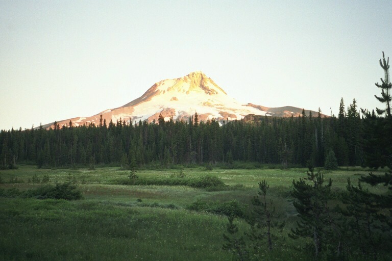 blooming flowers caused me some difficulty with nasal allergies, but
not so much. I've been taking 1 Ibuprofen each night, and sore muscles
have never been a problem. My knees did hurt a bit after long downhills.
blooming flowers caused me some difficulty with nasal allergies, but
not so much. I've been taking 1 Ibuprofen each night, and sore muscles
have never been a problem. My knees did hurt a bit after long downhills.
I slept in my tent, again, without pitching my fly. I woke up in the night, cold. After putting on my fleece jacket I was more comfortable, and able to sleep. The outside of the bag was wet, however, and I was sweaty. Not sure if the moisture was from me, or from the dew. I think that the tent is a lot warmer when I use the fly. That night I left my moleskin on, with bandages over the blisters. This helped me sleep. I woke at 5:45, just before dawn, to a clear, dark sky. I sat and watched the sun rise and illuminate Mt. Hood, striking the top of the mountain before illuminating the meadows below resulting in a spectacular view of the bright snow covered peak.
I wanted to make sure that I got back to the trailhead before my pick-up
time, and still had the White River Valley to cross. Some stories I read
or heard described the White River as sometimes being wide and deep, and
hence uncrossable. The streams are usually at their lowest flow in the morning,
so I wanted an early start. I had a quick breakfast of 4 cups of hot tea,
and packed up trail mix and bars and got going by 6:45. Pretty soon I came
to Newton Creek, which was another wide bolder strewn valley. The 'preferred'
crossing points for these streams often change with the seasons, and are
not always directly in front of where the trail comes to the stream. In
these sections, hikers have placed cairns, and sometimes flagging tape, which
lead to the preferred crossing point. At Newton Creek I started following
these markings upstream, to a point that may have been the preferred crossing,
but was far from dry. A bit upstream I say a tent, with a couple stirring
about. Figuring that they must be at the preferred crossing, I hiked up
to their campsite. The wife of the pair quickly dressed and came out of
the tent. She very cheerily directed me back down stream, pointing out the
area that they found to cross. They started out at Ramona Falls the day
that I hiked through there. I passed them briefly at Bald  Mountain and apparently was near them for most of the trail. My
side trip to Elk Meadows allowed them to pass me. The crossing was wet,
but not so deep, so I went across in my slippers. This was a good choice
as it allowed me to hike the rest of the day with dry socks and shoes. The
rest of the crossings that day were dry. White River has eroded a huge valley,
strew with bolder sized rocks. When full, the river is probably 200 yards
wide, but when I crossed, there were two tributaries, each about 10 feet wide,
and hopable. The White River Valley is notable for it's expansive stark landscape
made up of sand and boulders with no vegetation. The river banks were very
steep, and required a bit of a scramble up and down. As I was hiking down
into the valley, I could easily identify a faint rock lined trail through
the wash among the boulders. However, one I got to that area, it was very
difficult to follow the trail. Cairns marked the way, but seemed to mark
several ways. There was a sign that said that the trail on the other side
came out at a tree-covered ?? (a word that I cannot remember, and did not
know the meaning of, so much for my Doctorate in Engineering). Luckily,
as I was wandering around, trying to find my way, two hikers emerged from
the woods on the other side of the River. At least now I knew where I needed
to end up, even if I wasn't sure how to get there. Soon they came up to
me with dry feet, so I knew that there was an easy way across. They were
hiking the loop counter clockwise, and were carrying considerably less equipment
than I. Some of this is due to shared equipment (such as tent, filter, stove,
cook gear), but I suspect that they were following the 'lightweight' backpacking
philosophy. One of them was wearing a vest made out of mesh material,
full of pockets, all of which seemed to be full of stuff. Interesting.
The literature about hiking in the wilderness area repeatedly cautions hikers
to carry the 'ten essentials; whistle, map and compass, flashlight with extra
batteries, extra food and clothing, fire starter, first aid kit, pocket knife,
sunburn protection, and waterproof matches. I think that this hiker was
wearing his ten essentials (plus a few more) in his vest. After crossing
White River, I spied the couple that passed me the first night, just ahead
of me on the trail. I took a break, and gave them their privacy.
Mountain and apparently was near them for most of the trail. My
side trip to Elk Meadows allowed them to pass me. The crossing was wet,
but not so deep, so I went across in my slippers. This was a good choice
as it allowed me to hike the rest of the day with dry socks and shoes. The
rest of the crossings that day were dry. White River has eroded a huge valley,
strew with bolder sized rocks. When full, the river is probably 200 yards
wide, but when I crossed, there were two tributaries, each about 10 feet wide,
and hopable. The White River Valley is notable for it's expansive stark landscape
made up of sand and boulders with no vegetation. The river banks were very
steep, and required a bit of a scramble up and down. As I was hiking down
into the valley, I could easily identify a faint rock lined trail through
the wash among the boulders. However, one I got to that area, it was very
difficult to follow the trail. Cairns marked the way, but seemed to mark
several ways. There was a sign that said that the trail on the other side
came out at a tree-covered ?? (a word that I cannot remember, and did not
know the meaning of, so much for my Doctorate in Engineering). Luckily,
as I was wandering around, trying to find my way, two hikers emerged from
the woods on the other side of the River. At least now I knew where I needed
to end up, even if I wasn't sure how to get there. Soon they came up to
me with dry feet, so I knew that there was an easy way across. They were
hiking the loop counter clockwise, and were carrying considerably less equipment
than I. Some of this is due to shared equipment (such as tent, filter, stove,
cook gear), but I suspect that they were following the 'lightweight' backpacking
philosophy. One of them was wearing a vest made out of mesh material,
full of pockets, all of which seemed to be full of stuff. Interesting.
The literature about hiking in the wilderness area repeatedly cautions hikers
to carry the 'ten essentials; whistle, map and compass, flashlight with extra
batteries, extra food and clothing, fire starter, first aid kit, pocket knife,
sunburn protection, and waterproof matches. I think that this hiker was
wearing his ten essentials (plus a few more) in his vest. After crossing
White River, I spied the couple that passed me the first night, just ahead
of me on the trail. I took a break, and gave them their privacy.
The next section of the Timberline Trail goes through the Mt. Hood Ski
resort. This detracted some from the 'wilderness experience' but was not
so bad. This is the first section of the trail where I encountered a significant
amount of litter. The last couple of miles, east of the Timberline Lodge,
are again coincident with the Pacific Crest Trail. Here the trail is out
in the open again, and winds through some nice blue and purple meadows.
At that junction with the Pacific Crest Trail (PCT), I took a break, ate a
snack, and changed my socks. Just then a hiker named Brad came up the trail
and introduced himself and asked me where I had been hiking. At that point
I was just a couple of miles from the end of my 40-some mile trek around Mount
Hood, so I was feeling pretty puffed up and told him that I was on my fourth
day of a hike around the mountain. Brian told me that he was hiking the
Pacific Crest Trail. He has been on the trail for about a month now, starting
somewhere in California, and hoping to make it to Canada in another month
or so. He thought that the trail through Washington would slow him down.
Once that sunk in, my ego was deflated somewhat. Fascinating. S hortly after Brad hiked on, Trevor came by. He was another PCT hiker
who started at the northern California border, and was going to stop at the
Columbia River. Trevor told me that he and Brad hike together off and on,
as they had similar paces. Brad told me that a lot of the PCT was through
deep, dark forest, and hence was boring. Just before he joined me, the
trail opened into the sunlight, with great scenery, so Brad was in high spirits.
Both of them were looking forward to taking the afternoon off at the Timberline
lodge where they would eat, and resupply. Even after being on the trail
for a month, they looked better than I did. Compared to the day hikers,
both Brad and Trevor were chatty and suggested that we meet up at the lodge.
I guess that a month alone in the wilderness would do that. They scurried
on ahead of me, easily outpacing me. I noticed that Trevor carried his
duct tape wrapped around his hiking sticks, ... Nice hint.
hortly after Brad hiked on, Trevor came by. He was another PCT hiker
who started at the northern California border, and was going to stop at the
Columbia River. Trevor told me that he and Brad hike together off and on,
as they had similar paces. Brad told me that a lot of the PCT was through
deep, dark forest, and hence was boring. Just before he joined me, the
trail opened into the sunlight, with great scenery, so Brad was in high spirits.
Both of them were looking forward to taking the afternoon off at the Timberline
lodge where they would eat, and resupply. Even after being on the trail
for a month, they looked better than I did. Compared to the day hikers,
both Brad and Trevor were chatty and suggested that we meet up at the lodge.
I guess that a month alone in the wilderness would do that. They scurried
on ahead of me, easily outpacing me. I noticed that Trevor carried his
duct tape wrapped around his hiking sticks, ... Nice hint.
I finished my trip, arriving back at the Timberline lodge at about 1:00. The lodge was FULL of people. Two tour busses were in the parking lot, and there must have been another group of elderly guests and a bunch of independent tourists. By then I was pretty hot, sweaty, smelly, and quite thirsty. So, the first thing that I did was to take off my pack, grab my water bottle, and head for the water fountain. The lodge is a historic building, built of huge wooden timbers as a work project during the depression. It is owned and operated by the park service. At the center of the two-story lobby area is a huge stone fireplace with hearth on both floors outfitted with a gigantic iron grate. There are paintings and murals all around, including the wall just behind the hand made water fountain which is just inside the lobby. So I am standing at the water fountain, bent over drinking and filling my bottle, when I see, out of the corner of my eye, a tall blonde women in a park service outfit step up next to me at the water fountain facing the lobby. I thought that was a bit strange, but then I heard sounds of a number of people behind me. I stand up and turn around, and there must be 30 people standing there staring at me, some with cameras pointed. It turns out that the water fountain, and the mural behind it, is one of the stops on the tour of the lodge! Some return from the wilderness for me!
I then called Ann on the cell phone, and got the answer machine at the hotel. I figured that she was already on her way to the Lodge, but I left a message telling her that I was fine, and at the Lodge and would wait for her upstairs. I washed up a bit, and put on some clean-ish clothes and found a place to sit in the upstairs lobby. At about 2:45 the couple I met at Newton Creek showed up. They cleaned up much nicer than I, and headed for the restaurant. I never did find Brad or Trevor. Probably they went to the day lodge and ate. I get very reflective at the end of a trip, and wanted to be alone to think.
So, even after all the warnings and worry, I made it back just on schedule. Ann had a copy of the schedule, so I expected to see her walk into the lobby at any minute. Except, what Ann heard was that I intended to make it in 4 days, but would probably need extra times because of the poor trail conditions. Since she didn't hear from me on Wednesday night, she assumed that I would not complete the trail on Thursday. So, instead of being on her way to the Lodge, she was out shopping in Thursday! When she returned to the hotel and hear my message, she then realized that she didn't even know how to get to the Lodge from Portland! To compound the mixup, I turned the cell phone off after placing the call, so she had no way of calling me to let me know that she would be late. Well, she eventually found travel directions, and made it to the Lodge to pick me up. She was upset by the miscommunication, but we were both happy to be together again.
I greatly enjoyed this trip. Physically, this was a difficult trail, but I was well prepared, and the trip was well within my physical limits. My equipment, and equipment choices worked very well with a few exceptions. I was not so happy with my cooking, ..., there I need more practice. I was pretty hungry when I got off the trail. I should have also brought shoes for stream crossings. Otherwise, I was well equipped, although with the nice weather there was not so much stress on the choices I made for clothing and shelter.
The trip was a bit more challenging mentally. First, I was alone. One can argue that this was not so smart, going into the woods by myself. Certainly this added some danger and hence fear to the trip. The sense of fear and anticipation was pretty much a constant feeling throughout the trip. Most of this was a fear of the unknown, compounded with many dire warnings about how difficult or dangerous things could be. I was particularly afraid of the snow crossings, actually having nightmares about falling and sliding. In actuality, the snow turned out to be no problem at all, I just needed to take time, develop the proper technique, gain some confidence and stay focused. My next biggest fear was of the stream crossings. These also turned out to be easy. For me, I simply needed to be willing to get wet, and wade through the stream. This is easily the safest way to cross. If I had water shoes, I would have been much more willing to do this from the start. Another fear was of not reaching my destination in time. Here again I was always early. Some of this uncertainty was due to the dire warnings about the condition of the trail, and some was due to my lack of experience in backpacking. I didn't know what rate to expect. As it turned out, I averaged about 1 1/2 miles per hour, including lunch and all breaks. Remarkably, this did not vary so much even though the terrain did. Because of this uncertainty, I found myself rushing along the trail, seldom taking any of the side trails, or stopping to enjoy the view. I would do this differently next time. Even at night I would have trouble relaxing. Fear of animals, the dark, or anticipation of tomorrow's trail would creep in. Interestingly, on my next two backpacking trips, when I was with other people, I experienced none of these fears.
Even though there were other people on the trail, I was able to experience a strong sense of wilderness and isolation at some points on the trail. The splendor of the natural surroundings was magnified by beautiful weather which produced bright blue skies and crystal clear views of the mountain and its surroundings. This trip would be well worth doing again. Now that I know what to expect, I am sure that I would enjoy the trip even more than I did the first time. Additionally, there are several side trips that I would take. In particular, I would take the opportunity to hike up Yokum Ridge or Cooper Spur to see the glaciers up close.
I bought the e-book description of the Timberline trail from trails.com at http://www.trails.com/explore/Tcatalog_trail.asp?TrailID=HGW085-025
This was a very helpful guide, I should have taken the advice of the author and taken more of the side trips he suggested. I also stopped at Barnes and Noble in Portland and browsed a number of other trail guides before the hike. (more warnings ...)
I bought the Mount Hood Wilderness Map, 1:30,000, Mt. Hood / Columbia Gorge Recreation Map, published by Geo-Graphics, purchased at REI in Portland. This was a good map, I used it often. I also bought the two 'Green Trails' maps that covered the Timberline trail. I did not use these.
Timberline Trail #600, A brief guide. Available at the visitor's center is a helpful brochure. This one lists mileage between landmarks, some hints on water availability, and an elevation profile.
http://www.mthood.org Mt. Hood Info Center. On the way to Mt. Hood on Rt 26. (503) 622-7674 A good source of general information, but they were out-of date with trail status info. Particularly early, or late in the season, the trail conditions can change rapidly, and it is difficult for the info center to stay current. You need to talk to people who have been on the trail. Stop at REI and ask around. Call or write the info center, and they will send info including a Timberline Trail brochure.
http://www.fs.fed.us/r6/mthood Mt. Hood recreation web pages, trail status.
http://www.naturenw.org/ Link to info on many trails in the area
http://www.nwhiker.com/timberline600.html Link to online and interactive description of the trail, including photos. http://www.topozone.com/map.asp?lat=45.31170724860637&lon=-121.72497495535661&s=25&size=l&symshow=n online topo maps, pointed to a portion of the Timberline trail
http://gorp.com/gorp/location/or/ww_portland2.htm#top Online description of the Timberline Trail including a suggested 4 day itinerary.
http://www.seawfo.noaa.gov/products/OSOTIM Up-to-date weather observations on Mt. Hood above Timberline Lodge.
Hmmm,..., do you think that I over-researched this? ???
Part of the trail runs through a designated Wilderness Recreation Area. A self-issued permit is required to hike and camp there. Sign-in boxes were posted whenever the trail crossed this boundary. Take a card from the box, fill it out, leave one copy behind, and hang the other on your pack. I saw no enforcement officers on my trip. The permit is free.
A Wilderness area pass is necessary to park in the wilderness area, except at Timberline Lodge. These can be purchased at the info center, REI and other locations.
There are a lot of outdoor outfitters in the Portand area. Is shopped at the REI which is located in the shopping mall just over the bridge, north of Portland. It is a big store, and the employees were very helpful. They had a great selection of lightly used hiking boots which proved to be a gold mine for me.
4 pair of heavy socks
