![]()

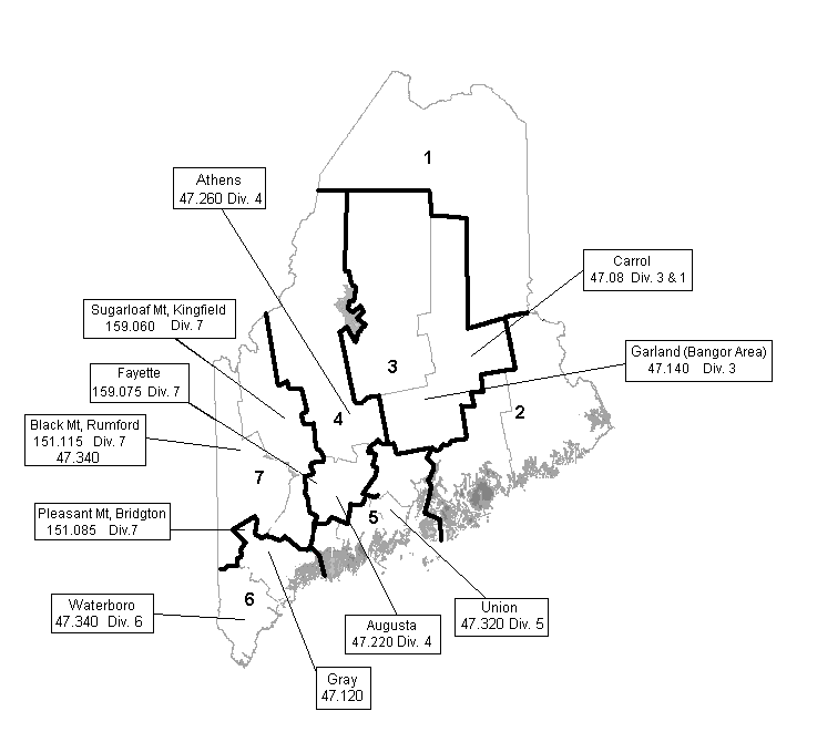
This is a map of the seven divisions of the Maine Department of Transportation. Currently, the MDOT uses a VHF Low-Band system, with a series of repeaters. The exception is Division 7, which currently utilizes a combination of VHF Hi-Band and Low-Band repeaters. *Note that two of the four Division 7 repeaters are not actually located within Division 7. I have listed only frequencies, locations, and designations that I have personally verified as correct.
47.040 (Truck-to-truck)
47.080
47.100 - Ch.10 (Usage?)
47.140 - Ch. 15 (Div. 3 Bangor)
47.220 - Ch.22 (Augusta Repeater)
47.320 - Ch. 26
47.120
47.260
47.340 - Ch. 29 (Waterboro Repeater)
Occasionally, especially during snowstorms, you will hear touch-tones (like somebody dialing a phone) on 47.220. These are the Bangor and Augusta offices turning on the "REDUCE SPEED 45 MPH" signs up and down the interstate. If you notice, the signs have an antenna on or right near them. They are activated using touch-tones on 47.220.
47.100 is used from about Pittsfield north up I-95 to the Bangor area. I have heard both dispatch-type communications on a repeater as well as truck-to-truck traffic simplex.
DISCLAIMER: The information provided within this web page and all information located within the sites linked to this page are for informational purposes only. The monitoring and/or publishing of contents heard on any of these frequencies could be in violation of local, state, or federal laws. The author of this page recommends that this information is used in a lawful manner. It is recommended that you should contact your local law enforcement agency before undertaking any activity related to the data provided here. The author of this page does not guarantee that the information here is accurate, correct, workable or factual. The author of this page does not assume any liability, nor is responsible for, any damages resulting from the information provided here.