Back to HomePage
Somaliland
Introduction
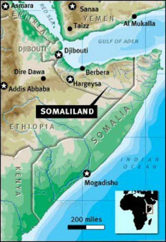
Somaliland is
situated on the eastern horn ofAnd lies between the 08�00' - 11�30' parallel north of the equator
And between 42�30' - 49�00' meridian east of the Greenwich.
It shares borders with Republic of Djibouti to the west,
Federal Republic of Ethiopia to the south and Somalia to the east. Somaliland has a coastal line to the north of the country which extends 460 miles along the Red Sea.
(Click map to see it in detail)
GEOGRAPHY
Somaliland is about the size of
England and Wales with an area of 137,600km� (68,000 sq. miles).
POPULATION
The population of Somaliland is
estimated at around 3.5 million. The average population growth rate is 3.1%.
Population density is estimated at approximately 25 persons per sq. kilometer.
Fifty-five percent of the population is either nomadic or semi-nomadic, while
45% live in urban centers or rural towns. The average life expectancy for the
male is 50 and for females it is 55.
LANGUAGES
Somali is the official language.
Arabic and English are the other official languages.
RELIGION
100% is Muslim and Sunni
particularly Shafi'i
TOPOGRAPHY
The major topography features are:
The low-lying coastal plains known as the Guban, running some 70 km inland with a very hot summer climate.
A high escarpment running east-west parallel to the coast and rising to over 2000m at Eri Gavo.
A plateau to the south of the mountains known as Ogo, extending to Ethiopia, with an average altitude of 1200m.
Further inland and to the south is the Haud, red sandy plains
stretching southwards into Ethiopia, where altitudes fall to some 500m.
CLIMATE
The country has a tropical monsoon type of climate. However, there are
four distinct seasons. A main rainy spring season from April to June,
followed by a dry summer season from July to September. Then there is a
short autumn rainy period from October to November, and finally a long
dry winter from December to March. The latter is the most difficult for
the animal herding rural population and to the farmers to a lesser
scale. If the April-June rains fail the result is a draught that could
kill most animals which have already been weakened by the December-March
dry season, which also severely hits the country's economy
Annual average precipitation ranges from less than 1000 mm on the coast
to 500 mm inland except for a limited areas where it may reach 900 mm.
Rain variability is very high. Hargeisa, the capital, for instance, with
a long term average of some 400 mm has recorded variations from 209 to
810 mm per annum.
Temperatures also show some seasonal variations. The winter months are
normally cool with average December temperatures in the range of 15 -
26�C, while the summer months are the hottest averaging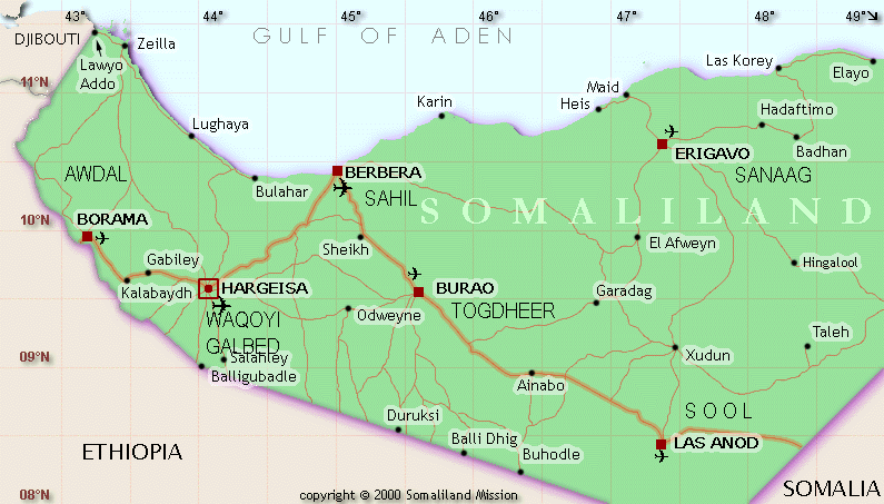 26 - 32�C in June
CAPITAL CITY & MAIN TOWNS
Hargeisa: Capital
Berbera : main port
Burao,Borama,Erigavi,Las'anod
See The map
POLITICAL
SYSTEM
The country has a republican form of government. The
legislative assembly is composed of two chambers - an elected elder's
chamber, and a house of representatives. An elected President and an
elected Vice-president head the government. The President nominates the
cabinet which is approved by the legislature. There is an independent
judiciary The country has three political parties. i.e UCID party and
UDUB Party, Kulmiye Party
ECONOMY
Currency: Somaliland shilling
The exchange rate the shilling against the US Dollar in end of April 2007 was
1$ = 6300 S/L shilling
IMPORTS & EXPORTS
The backbone of the
economy is livestock. The total livestock in the country is estimated at 24
million. In 1996, 3 million heads of livestock were exported to the Middle
Eastern countries. The country also exports Hides, Skins, Myrrh and Frankincense
in smaller scale
IMPORTS
Annual imports exceed US$200
million. Principal imports include food commodities, apparel and footwear, fuel,
building material, Machinery, vehicles, and chemicals
MINING
Mining is limited to quarrying at
the moment. There are, however, confirmed deposits of Oil, Gas, Gypsum, Lime,
Mica, Quartz, Lignite Coal, Lead, Gold, Sulphur .
FISHERY & MARINE RESOURCES:
The fishing industry is still
underdeveloped, but the country has 600 mile long coast with rich fishing
grounds. Somaliland is strategically located at cross roads between Africa,
Europe, The Middle East and South East Asia. In 1996 up to 846 vessels called on
Berbera port on the Red Sea which has the potential to develop into a major
commercial centre