SAN JOAQUIN RIVER CALIFORNIA |
BY MICHELLE TAN |
|
|
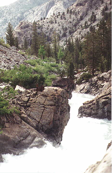
| THE SAN JOAQUIN RIVER flows through this narrow gorge in Goddard Canyon |
San Joaquin, California, surfaces in the Sierra Nevada. It generally flows towards the northwest through central California and confluences the Sacramento River shortly before entering the Suisun Bay, near Oakland. The river 560km in length, is part of an extensive irrigation and power project that has created a rich agricultural region in the semiarid San Joaquin Valley.
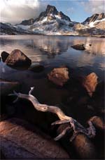 |
| HIGH SIERRA: The San Joaquin begins at pristine Thousand Island Lake, just west of Mammoth Lakes, with 13,157-foot Mount Ritter as its backdrop. |
|
|
| Some parts of the San Joaquin next to Fresno still has the natural charm of the unblemished river in the early part of the century. |
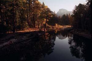 |
| Merced River begins in the pristine high country of the Sierra Nevada. It can be seen in Yosemite National Park with Half Dome in background. It flows into the San Joaquin River. |
Short summary of threat
Despite the record floods and the poor water quality, the construction of new homes and businesses on the San Joaquin river floodplain has been well underway as soon as the flood subsides. This poses a huge risk on more people and properties, eliminating the water's natural cleansing functions of the floodplain wetland and reducing the already limited habitat for the fish and wildlife.
The Risk
Heavy flooding recently damaged the vulnerability of homes, businesses, and farms in the San Joaquin Valley where thousands of residents make a living on the 100-year floodplain. Despite the billions of state and federal dollars spent on the most complex system available of structural flood control project, the flood losses continue to rise as the nation's richest agricultural valley continues to urbanize. The calculated flood losses to the 1997 flood, currently the costliest flood in the nation's history, tops $2 billion as flood waters submerged 250 square miles of the Central Valley, destroying 23,800 homes, and forced 120,000 people to be evacuated. the flood also caused the death of 9 people.
Despite the huge losses, development resumes in the river's floodplain. 58,000 new homes planned or are under construction in locations vulnerable to the floods. In fact, a number of these construction sites were under water for weeks even months in 1997.Just weeks after floodwaters dropped, the Fresno City Council approved the construction of 11 new homes next to the river. A builder in Sacramento was able to persuade its City Council to allow him to move a levee closer to the river to 'reclaim' the floodway-the land closes to the raging river-for homes and businesses.
Very few river have been altered as the San Joaquin. Approximately 98% of the river's natural flow is directed at the Friant Dam near Fresno to irrigate huge farmlands situated in the southern San Joaquin Valley. At least 100 miles of the river is left dry in the summer each year. The lower section of the river is polluted by excessive salt and selenium from the nearby farm fields, as well as the waste from hundreds of dairies and wastewater treatment plants, which is then pumped 130 south through the Delta-Mendota Canal.
A variety of sources drain their pollution into the San Joaquin River unchecked that the lower San Joaquin has been identified as one of the state's most polluted rivers. Irrigation run-off from the highly saline soils in the Central Valley's west side dumps tons of selenium into the river yearly. In the 1980s, selenium was identified as a health hazard when drainage water containing high amounts of selenium deformed and killed thousands of waterfowl in Kesterson National Wildlife Refuge near Merced, California.
Salt and boron, are drained off farm fields, making river water nearly unusable for both farming and drinking water and hampers the survival and reproduction of fishes and other aquatic species. Urban storm water run-off high in pesticides and other compounds is thought to be responsible for several fish kills in the river near Stockton and in tributaries such as Smith Canal and the Calaveras River.
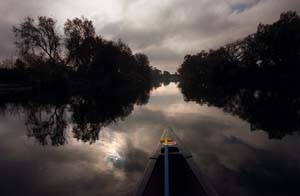
This is the San Joaquin River looking west at sunset near Mendota.