|
 |
PUERTO PRINCESA SUBTERRANEAN RIVER
NATIONAL PARK AND THE ANCESTRAL DOMAIN OF KAYASAN: A WORLD HERITAGE |
|
| SUMMARY |
| |
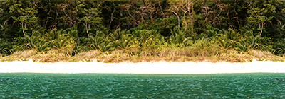
Conservation of a living heritage; is not an easy task. It poses a multitude of problems that is complex and interrelated. Economic progress, population growth, and unplanned tourism pose a great danger to our fragile nature. St. Paul Subterranean River otherwise known as Puerto Princesa Subterranean River National Park (PPSRNP) has long aroused curiosity and became an object of interest for most of the people. Limestone karst mountains shaped from delicate hands of nature have an appalling beauty that cradles much of our rich natural and cultural heritage. It features an eight-kilometer underground river that extends from the mountains and flows out to the sea. A distinguishing feature of the river is that it emerges directly into the sea thus the lower portion is subject to tidal influence that makes it a significant natural phenomena.
|
| |
St. Paul range has also an abundant tropical rainforest teeming with trees and marine ecosystem, a full "mountain-to-sea" ecosystem and protects some of the most significant forest in Asia. The park has a rich biodiversity with a high percentage (15-20%) of endemism. The remoteness of the area proved to be advantageous to the indigenous people, the Bataks and Tagbanuas, who find solace deep in the jungle. Basically hunters and gatherers, they find their means of livelihood from the forest which is far from encroachment of the lowlanders. They, however, still practice swidden farming. Having their own diverse cultural heritage, these indigenous people are in danger of losing it if not properly managed and preserved. The recently concluded international convention finally gave new direction to the conservation and preservation of Puerto Princesa Subterranean River National Park and to the ancestral domain that lies within this site. |
| |
| THE SITE |
| |
St. Paul Cave was known to people since ancient times, in their thoughts it was inhabited by a spirit that prevented them from entering the cave. The parks territory and surroundings are the ancestral lands of the Batak people, of whom only 200-250 survive, and Tagbanua communities which live around the boundaries, including the coast. The Tagbanuas unlike the Bataks are more acculturated to the Christian culture. (DENR, 1992 Nomination 1998) However, the tide is slowly changing, due to growing social awareness, the indigenous community are getting more contacts with the local people and getting more used to host tourist once in a while. |
|
St. Paul Park has a total area of 20,202 hectares that includes the land area of the national park, a core zone of 5,753 ha and a buffer zone of 14,449 ha. It was then suggested by PAMB to extend its area. Prior to the inscription, it was also recommended by the world heritage committee to include the adjoining catchment areas to assure the sustainability of its own biodiversity. Ownership of the core zone was officially transferred from the national government to the city government of Puerto Princesa in 1992. Part of buffer zone was awarded to the indigenous community in recognition to their ancestral domain claim. The CADC was awarded in February 28, 1996 covering 7,530 hectares bounded by Caloga range in the north, by Cleopatras needle in the east, by the Babuyan River in the west, by Barongbongan range and the ancestral domain at Barangay Maoyon in the south. Ownership of the buffer zone is mixed and includes private ownership. |
| |
|
The national park is home to Palawans rich and unique flora and fauna. A recent survey conducted by the National Museum and the Palawan Tropical forestry protection Programme recorded 149 vertebrate species including 12 species of mammals and nine species of amphibians that are endemic to the island. |
| |
The ancestral domains of Cabayugan and Kayasan on the parks periphery are home to about 1,000 indigenous people belonging to the Tagbanua and Batak tribes. Still, the few of the community members in their traditional ways of hunting, gathering and slash and burn agriculture in the great forests between the park and San Rafael on the east coast of Palawan. |
| |
| SITE MANAGEMENT |
| |
The national park was established in 26 March 1971 under the Presidential Proclamation No. 835 and managed by the Department of Environment and Natural Resources. The territory of the park forms the core zone of the Palawan Biosphere Reserve recognized by the UNESCOs Man and Nature Programme in 1990 and a core zone of the Environmentally Critical Area Network (ECAN), the central element of the Strategic Environmental Plan for Palawan. Under the Republic Act 7586 (NIPAS Act of 1992), the boundaries of the site was inscribed, and the management was officially transferred to the city government through a multi-sectoral represented protected area management board. The park is ultimately under the jurisdiction of DENR but has been devolved to the city government and being managed by a multi-sectoral represented protected Area Management board where the city mayor chairs the board and representative of the City Tourism Council, the DENR, the Palawan Council for Sustainable Development and the Palawan NGO Network, Inc. as members. |
| |
Since the site was inscribed to the world heritage list, the area was extended to include 20,202 hectares of rainforest, karst mountains, caves, and its marine ecosystem. This was prompted by the recommendation of the World Heritage Committee to increase it size to improve the sustainability of the subterranean river. The Puerto Princesa Subterranean River national Park was inscribed to the world heritage list in 1999 and passed the criteria I, ii, and iii of the natural heritage sites. |
| |
The Protected Area Management Board (PAMB) also encourages the participation of the local community in decision making by conducting consultations concerning plans and management strategies being employed. |
|
| |
| |
|
|
| reposted: april 26 2006 |
|
|
|
|