![]()
Regional Differentiation
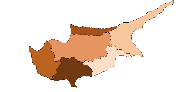
Politically Cyprus is divided into six districts including districts administrations, with limited competencies. Since 1974 only three, Lefkosia, Larnaca, Lemesos and Paphos are under complete control of the Greek-Cypriot government, the fourth, Amochostos, is divided, whereas Kyrinia is part of the occupied Turkish zone.
Concentrating on the agricultural performance of the districts with their in total 393 municipalities, they appear to be very heterogenous. For a more homogenous classification the island can be divided into four agricultural regions consisting of 24 sub-regions. This classification is mainly based on natural environmental resources, micro-/meso-climates, but also social- economic factors, which are interrelated with the environmental factors, such as agricultural growing patterns, agricultural incomes, etc. This regional classification provides a valuable overview over the regional structural development and development disparities. The agricultural economic regions are as follows:
![]()
Coastal Zone: This zone follows the coastline, starting in the North-west with Tylliria to the South-east with Parallimni. The entire coastal region contains of 87 villages including 37.5 % of agricultural holdings. Special characteristics are the mild and humid winters with an annual average precipitation of 335mm-560mm and an annual average temperature of 32 C.
![]()
Dryland Zone: The dryland zone is the biggest homogeneous region consisting of 163 villages and 41.5 % of total agricultural holdings. The region embraces the eastern and western Mesaoria plain and part of the mountainous areas around Nikosia and Lemesos.
![]()
Vine Zone: The vine areas a specifically found in the south-west of the Troodos mountains between 300-1200m. There are 77 villages found in the area and 8.3 % of agricultural holding, with a declining tendency.
![]()
Mountain Zone: This zone is the heart of the Troodos mountains, adjacent to the vine areas. There are still 66 villages comprising of 11.2 % of agricultural holdings. The area is characterised by ist steep slopes, which are a major obstacle for farmers, lowest average temperature and high annual precipitation.
![]()