 MAPS AND GLOBES:-
Maps and Globes are representations of the earth's surface in miniature.A globe represents the whole surface in its correct spherical form.A map is aconventional delineation of the earth's surface,or a portion thereof on a flat sheet.
Without the use of maps GEOGRAPHY cannot be made really interesting or practically useful. With complete and graphic maps,properly interpreted and accompanied with pictorial illustrations and descriptions,one should get almost as good an idea of a country as if one had actually visited and travelled over it.
CARTOGRAPHY :-
Cartography or map-making,is the art which has realised the representation of the world in miniature.With the assistance of astronomy,mathematics ,and the arts of drawing ,engraving and printing
it has gradually developed to its present stage of perfection and it may be said that there is almost no limit to the possible improvement of maps in conveying exact and graphic descriptive information.As year after year the civilisationof the world advances, and as the unknown is revealed and surveyed, as man alters the face of the earth with his new settlements, new states ,cities , railways, canals,
land reclamation and cultivation ,all these changes are depicted in the maps of the times.
PRACTICAL PROBLEMS :-
at the oyt-set map-making presents two problems --first,that of representing the curved surface of the earth on a flat surface, and second , that of representing the various surface features and other information which different
kinds of maps are intended to convey. When we see the earth from space it appears as a great globe ,surrounded by clouds .But
even though space flights are now a reality and we have birds-eye views of continents we still need to make our maps by marking down ascertained measurements and positions.
The problem of the Projection of Maps underlies any attempt at map-making.Having prepared the projection, we are furnished with the network of lines,the parallels of latitude and meridians of longitude, which form the basis of all maps ,and
on which all positions are laid down and features delineated according to scale. The second problem ,the REPRESENTAION of the various features can best be understood if we think of a map as a reduced facsimile of the features on the earth's surface.
In making a map,for e.g only a four-millionth of the scale of nature ,the reduction is so great that a town becomes a mere dot and can only be shown by a dot, a route becomes a mere hair-line and can only be shown by a hair-line, a mountain peak is a mere pimple and can only
be represented as a pimple. Thus all the many and varied features shown on maps are indicated by SYMBOLS or conventional equivalents.
The representation of special features must of course depend upon the scale of the map.In proportion as maps are larger and more elaborate ,the symbols are necessarily greatly multiplied, and map-making becomes more complicated; but in proportion as they are smaller they must be correspondingly
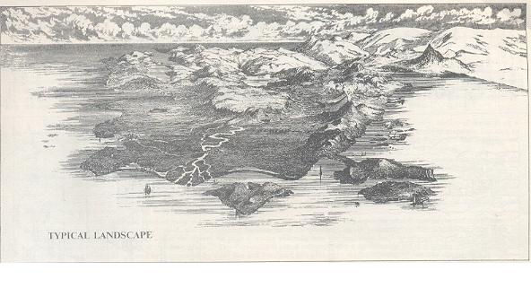
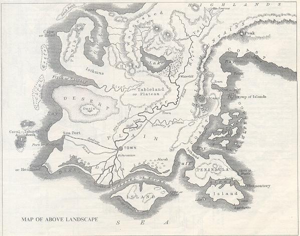
simplified. A comparison of the figure as shown below ,shows generally how the landscape features in a picture of an area are represented in the corresponding map of the same place. The conventional use of colors is also a considerable aid in
mapping--water is generally tinted blue, towns and buildings may be represented by a red tint and woodland by a green tint, whilst different colours may also be used to indicate different states or provinces , or to accentuate features of speacial interest.
PHYSICAL RELIEF :-
IN THE REPRESENTATION OF THE EARTH'S SURFACE, one of the most important and at the same time the most difficult feature to treat adequately is the phiscal relief of a country--the delineation of hills and plains , the distinguishing of high
grounds and low grounds.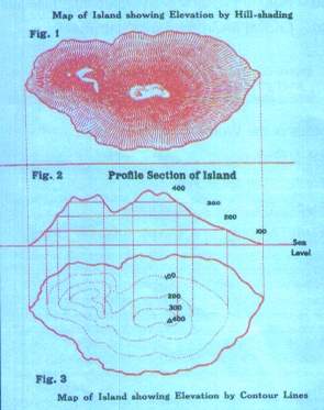 To do this clearly,effectively ,and correctly, enabling one at a glance to see shapes of surface relief and their comparative altitude, is one of the problems of map-making. The
two methods generally used are HILL-SHADING and CONTOUR lines , each of which may be treated in a variety of ways, and sometimes they are combined .The adjoining figure shows a mountains island with the hill slopes inclined by a method of HILL-SHADING called "hachures". These hachures are lines indicating the direction of the slope .Where the slopes are steep the lines are thick and close together
, making a dark shade;where the slopes are less steep the lines are finer and wider apart ,gradually tapering off and becoming lighter until they stop where the slope ends, so that there is no hill-shading on level country. Figure-3 shows the same island with the hills indicated by contour lines. The principle of showing elevation by CONTOUR LINES is illustrated by comparing fig. 3 with the profile section
in fig. 2. The coast line or sea-level line, where land and sea meet, is a natural contour line of uniform level. It is the first contour line, the zero, or base form which all height and depths are measured. Thus when we say that a hill is so many meters high or the sea is so many meters deep, we mean that number of meters above or below sea-level.If we imagine the sea rising 100 meters higher,it
would form another line of uniform level corresponding with the 100 meters contour line.The principle of showing relief by contours is thusto draw a number of lines of uniform level at different heights.On fig. 3 only a few liones are drawn ,merely to illustrate the principle of contouring, but to give an adequate representation of the relief they ought to be drawn at every e.g 50 meters or even closer intervals, according to the scale of the map. Contour lines are speacially well adapted for the represention of OCEAN DEPTHS, which are usually coloured with deepening shades of blue in proportion to depth.
To do this clearly,effectively ,and correctly, enabling one at a glance to see shapes of surface relief and their comparative altitude, is one of the problems of map-making. The
two methods generally used are HILL-SHADING and CONTOUR lines , each of which may be treated in a variety of ways, and sometimes they are combined .The adjoining figure shows a mountains island with the hill slopes inclined by a method of HILL-SHADING called "hachures". These hachures are lines indicating the direction of the slope .Where the slopes are steep the lines are thick and close together
, making a dark shade;where the slopes are less steep the lines are finer and wider apart ,gradually tapering off and becoming lighter until they stop where the slope ends, so that there is no hill-shading on level country. Figure-3 shows the same island with the hills indicated by contour lines. The principle of showing elevation by CONTOUR LINES is illustrated by comparing fig. 3 with the profile section
in fig. 2. The coast line or sea-level line, where land and sea meet, is a natural contour line of uniform level. It is the first contour line, the zero, or base form which all height and depths are measured. Thus when we say that a hill is so many meters high or the sea is so many meters deep, we mean that number of meters above or below sea-level.If we imagine the sea rising 100 meters higher,it
would form another line of uniform level corresponding with the 100 meters contour line.The principle of showing relief by contours is thusto draw a number of lines of uniform level at different heights.On fig. 3 only a few liones are drawn ,merely to illustrate the principle of contouring, but to give an adequate representation of the relief they ought to be drawn at every e.g 50 meters or even closer intervals, according to the scale of the map. Contour lines are speacially well adapted for the represention of OCEAN DEPTHS, which are usually coloured with deepening shades of blue in proportion to depth.
SCALES:-
maps reproduce great surfaces in little, and the relation of proportion which exists between the map and the actual surface it represents is called the scale. If the scale of the map is four-millionth of the scale of nature, then it is represented by 1:4,000,000. It may be expressed by stating that a centimeter on the map is equal to forty km .Topographical maps are usually named according to thier ratio scales; so we speak of the "fifty-thousand map" meaning the survey on the scale of one centimeter to five-hundred meters.
back to home page