| You can also click here to access our local streetdirectory: www.streetdirectory.com www.canfind.com.sg |
 |
| Elements of a Topographical Map |
 |
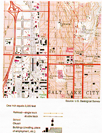
| Scales - line scale and RF (represenative fraction) Grid reference - Easting and Northings North arrow - directions and bearings Map symbols Contours - lines which join places of the same height above sea level - help us recognise the relief features on a topographical map - shows the steepness of slope closely spaced contour lines shows a steep slope and contour lines which are spaced far apart shows a gentle slope. - the gradient of the slope can be measured using the following formula: difference in height between 2 points distance between the 2 points Height can also be shown using spot heights, trigonometrical stations and bench marks. |
 |