Historical London
Underground Maps
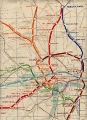
1907 Evening News Tube Map
Large copy of above portion | Full map: N.W. N.E. S.W. S.E.
Cover of folded map
This is a 22½ by 17½ inch map from 1907 (after the June 1907 opening of the Charing Cross, Euston & Hampstead Railway (CCEHR), but before Strand station was opened in November 1907). The map was produced by George Philip & Son Ltd and was sold for three (old) pence as the Evening News London Tube Map and Guide. Note that on the CCEHR what are now Goodge Street and Tottenham Court Road on the Northern Line were confusingly called Tottenham Court Road and Oxford Street, respectively. These names were changed to their current names (together with Euston Road to Warren Street) in 1908. Also note that this map calls the (now disused) South Kentish Town station Castle Road, which was the name originally proposed for the station.
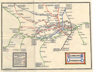
This is a beautiful 13¾ by 11 inch map designed by MacDonald Gill (younger brother of Eric Gill). It was printed by The Dangerfield Printing Company Limited, and is dated 1-3-22.
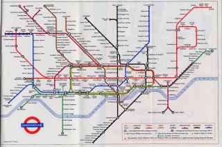
This is a 6½ by 5¾ inch folding card map from a series designed by F.H. Stingemore. The map dates from 1931/32, and certainly before the closure of Down Street Station in May 1932. Note the pencilled annotations of an early-1933 user of the map.
This is one of the early versions of the famous diagrammatic map invented and designed by H.C. Beck. The first Beck design was released to the public in January 1933. The map here is an 8 by 5¾ inch c.August 1933 version (after the opening of Cockfosters station at the very end of July 1933, and announcing the merging of Holborn and British Museum stations in September 1933). It is similar to the January 1933 design, but rings rather than diamonds are used to indicate interchange stations. Note that the Central (London) Line is orange and the Bakerloo Line is red. They received their present colours of red and brown, respectively, in 1934.
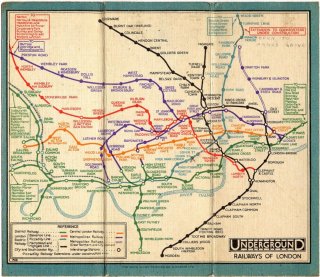
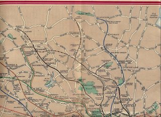
1939 Geographical Map
Large copy of above portion | Full map (excl. border): N.W. N.E. S.W. S.E.
Cover of folded map
This is the 1939 No. 2 (24 by 18 inch) geographical version of the Underground map issued by London Transport. This pre-war map shows many extensions planned before the start of the Second World War (some of which never happened) and gives details of the proposed opening dates of these extensions.
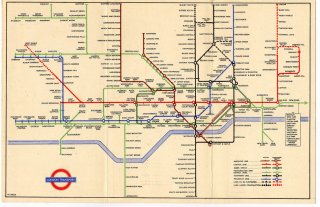
This is the 1948 No. 1 (9 by 5¾ inch) version of the map by H.C. Beck. For some reason, from 1937 until 1948, the Metropolitan Line was given the same colour (green) as the District Line. Note that this map shows "lines to be electrified" from Mill Hill East to Edgware and from Highgate to Alexandra Palace and to Finsbury Park, and a "line under construction" from Edgware to Bushey Heath. (See also the 1939 Geographical Map.) Unfortunately, these improvements to the Northern Line never happened.
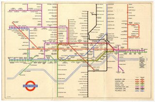
This is a 9 by 6 inch H.C. Beck map, dated January 1953. The back cover design is especially nice.
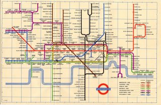
This is a 9 by 6 inch 1958 map, one of the later designs by H.C. Beck (the last design of his used by London Transport was issued in 1960).
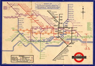
This is a 9 by 6 inch version of the map by Paul E. Garbutt. It was tipped in to a small book by Garbutt, called How the Underground Works, in a revised edition published by London Transport in 1968. I believe the map is from 1965/66, after the District Line stopped running in October 1964 from Acton Town to Hounslow West, but with no mention of the Victoria Line, part of which opened in September 1968.
References
- J.E. Connor, London's Disused Underground Stations, Connor & Butler Specialist Publishers, Colchester, 1999.
- K. Garland, Mr Beck's Underground Map, Capital Transport Publishing, Harrow Weald, 1994.
- D. Leboff & T. Demuth, No Need to Ask! Early Maps of London's Underground Railways, Capital Transport Publishing, Harrow Weald, 1999.
- Railway Clearing House, Atlas of London 1935, Reprinted by Ian Allan Publishing, Hersham, 2001.
- D. Rose, The London Underground: A Diagrammatic History (7th edition), Douglas Rose, London, 1999.
Links
- Clive Feather's Underground line guides Histories of individual lines, and lots more
- London's Transport Museum
All maps scanned from originals owned by the author.
[email protected] , 22 March 2026.
Top of page