
4.5 Nature
In this work, the Nature issue has been presented by two problems: biodiversity loss, which deals with threatened animal and plant species and protected areas, as well as forest degradation, which includes forestry and forest protection and improvement. This decision was made according to coverage of these problems in the examined SoE reports, where forests are in most cases treated separately.
In the OECD core set, this issue is divided into two; one is forests and the other biological diversity and landscape (OECD 1993). GEO-2 also treats them as two separate issues - forests and biodiversity (UNEP 1999). On the contrary, Dobris+3 deals only with biodiversity as an issue, and forestry is regarded as one of the driving forces which causes impacts on biodiversity (EEA 1998b).
The next two subsections show the most commonly used indicators connected to these two problems.
The main cause of biodiversity loss is habitat loss caused by land use changes; the major contributors to this are forestry and agriculture (EEA 1998b). Table A-8 in the Appendix shows the measured and proposed indicators for this problem in CEE countries, as well as in the Dobris+3 report (EEA 1998b), GEO-2 (UNEP 1999), and the OECD set of indicators (OECD 1993). Table 11 shows the coverage of selected indicators of biodiversity loss in CEE countries.
Pressure indicators in Table 11, described together as habitat alterations and land use changes, actually comprise different indicators: from road density to sown area to built-up area, because in CEE, there is no accepted common indicator which can show pressure on biodiversity caused by these factors. All these different indicators can show the situation on national levels, but, regional comparison is still not possible, because data on land cover and use is not available for most CEE countries. Figure 18 shows a possible way of presenting one of these indicators.
Threatened species, divided according to categories, are usually collected in red lists or red books on a national or regional level. This is a state indicator, also suggested by the OECD (1993) and included in the Dobris+3 (EEA 1998b) and GEO-2 (UNEP 1999).
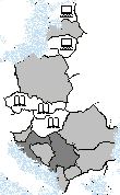
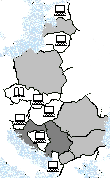
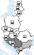
As opposed to many other issues and problems, response indicators are very well covered for this problem. One of them is the number and total surface of protected areas, which is covered in almost all SoE reports. A good way of presenting this information graphically is by using maps, as was done in the Norwegian SoE report (SoE Norway 1998) (see Figure 19).
|
|
|
|
|
|
|
|
|
|
 |
 |
 |
|
| Dobris+3 |
|
|
|
| GEO-2 |
|
|
|
| OECD 1993 |
|
|
|
|
|
Indicators present in the SoE reports on the Internet |
|
|
Indicators presented in the Dobris+3, GEO-2, and the OECD Core Set, or reported as measured in CEE countries, but not present on the Internet |
| Indicators not reported as measured in CEE countries, and not covered in the Dobris+3, GEO-2, and OECD Core Set |
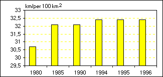
Figure 18. Road density in Lithuania as a way of presenting the pressure on biodiversity. The graph shows the differences between various years. It is easy to see a growth in road density since 1980, as well as predict the future trend. From: SoE Lithuania (1999) URL: http://nfp-lt.eionet.eu.int/nature.htm. Source: Lithuania Department of Statistics. Back
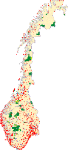
Figure 19. Protected areas in Norway. Different colors on the map show different categories of protected areas. It is also possible to see the size of protected areas in relation to the whole country area. From: SoE Norway (1998) URL: http://www.mistin.dep.no/biologisk_mangfold/Vernede_omrader-e.htm. Source: Directorate for Nature Management Back