Buffalo Lake Minnesota is a small commuity just 70 mile west from the cities of Minneapolis and St.Paul. In the afternoon and evening the town had seen it worst day in it history... A Torndado make a vitie that no one would like to have for company. Let's tell and show what happen there and around the region...
 |
The Fujita Scale is the show how stronge the strom is in terms to wind speed..
A word from the weather service.
The semi-stationary front that set up conditions for this week's weather is gradually moving east. But another contributing element may hover over Minnesota for some time.
The jet stream has parked farther south than usual for this time of year. This highway of air, which influences much of our weather, separates cold polar air from warmer air to the south, and it usually shifts north toward Canada in the summer.
Now, however, it has dipped deep into the United States, sweeping north over Minnesota, then returning to Canada. This week, its high-speed winds paralleled the storm front closer to the ground, Spoden said. "It creates a hole in the upper atmosphere," Spoden said. "Mother Nature doesn't like a hole, and she tries to fill it."
Nature's mechanism is to lift air from the lower atmosphere. So it became another force sucking muggy surface air to the level where it forms clouds - and trouble for people on the ground.
Supercells could form without help from the jet stream, but the stream adds to the weather's overall instability, said Edwards of the National Weather Service.
Latest Headline Page
Address:http://www.crh.noaa.gov/mpx/buffalo_lake.html
Changed:6:32 PM on Wednesday, June 25, 2003
 Twister cam destroyed by tornado | A tornado touchs down south of Kandiyohi, Minn., Tuesday, June 24. This tornado was one of several spotted within an hour of each other in the area.
Bill Zimmer Associated Press Published June 25, 2003 � Copyright 2003 Star Tribune. All rights reserved |
 | This was the office building for the town Grain elelvor.. This was a steel building. Not a wood frame building. |

What you can't see.
Is the roof on the right side of church is gone.

 The early evening was awash with rain. The weather forecaster have not seen strom out breaks like this before.
Yes they were in awl with the way the weather was working it way around the state.
And it was not doing what the through it would do. Or would go...
For they said that the Twin Towns wouldn't see any of this weather.
They were wrong..
 Metro Traffic |  |
Traffic was moving very slow in the morning. Well the freeway were flooded out. At I35 and I694 No traffic was moving because the road was closed because of water. Most of the hiways and freeways had water problem of some type...
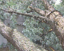
South Minneapolis was hit hard with down trees and power lines..
24 hours later there are still over 28,000 home and buisness with out power.
Crews Still Working To Restore Power
Jun 27, 2003 10:30 am US/Central
Minneapolis (AP)
Xcel Energy crews continue to restore power this
morning to homes in the Twin Cities.

As of 4:30 p.m. Friday, there were still over 1,000 power outages in
the
Twin Cities.
Xcel customers who are still without power should call the company's customer service center to make sure they're on the list for repairs. The number is 1-800-895-1999.
Denny Branca is the director of emergency response for Xcel. He says the company expects to have power restored to all of its customers by this evening. Nearly 250,000 Xcel customers in the Upper Midwest lost power in storms Monday and Tuesday -- including 200,000 in the Twin Cities region.
The company expects to work through the weekend in Buffalo Lake. A tornado struck the small city 70 miles west of Minneapolis on Tuesday, knocking out power to homes and businesses.
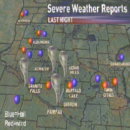
A Storm chaser was able to take photos of all Five (5) tornado in the state.
Plus there are more to see.
WCCO Slideshow
Address:Sorry this Slidshow has been close.
Changed:5:31 AM on Thursday, June 26, 2003
The view from Minnesota Public Radio..
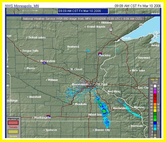
This the New look of the radar image of the National Weather Service. With this new look it will make it easy to find the area that need your attaition.
So feel free to learn more about this new tool. To keep you and your family out of harm way..
NWS Doppler on the web
Your tax dollar at work..