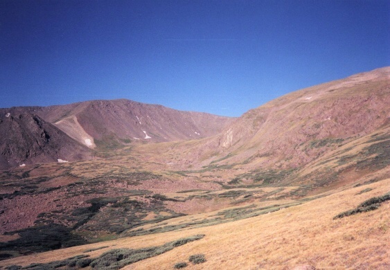
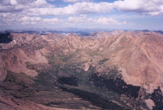
Mount Elbert (left), mostly bare of snow even though it was early July. View of Collegiate Peaks to the south (right).
Route: Started from lower parking lot near Elbert Forebay and followed 4-wheel drive road on foot to Mount Elbert Trail that we followed to summit.
Summit Elevation: 14,440 feet (highest point in Colorado)
Trailhead Elevation: 9,600 feet (lower parking lot)
Elevation Gain: 4,900 feet
Round-trip Length: 11.5 miles
Difficulty: Class 2
(Click here for discussion of Class System)
Pre-Climb: The alarm clock sounds at 3 in the morning. My Dad and I scramble out of Bed to get ready for the hike we had been preparing for, the last two years. We made plans, used hiking guides to plan out this climb.
We left the house at around 4 a.m. with plenty of supplies including food, water, warm clothing, and a camera. The drive is about 2 hours from Westcliffe. The scenary is spectacular and never gets boring as we drive along U.S. Highway 50 which runs parallel to the Arkansas River. The river was abnormally low due to the drought. As the sun began to rise it was wonderful watching it as it climbed over the Buffalo Peaks. I turned right on Colorado Highway 291 through Salida which cuts off a few miles and joined up with U.S. Highway 24.
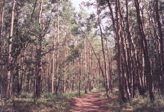
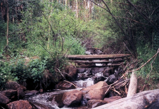
Aspen stands along the Mount Elbert Trail (left). Beautiful Elbert Creek along the Mount Elbert Trail (right).
The tops of the 14ers, Yale, Shavano, Antero, and Princeton, were now in the sun and were pretty, yet bare as there were only scattered patches of snow on their tops. Eventually, I reached Colorado Highway 82 where I took a left (West) towards Aspen. The turn-off for Elbert is confusing. Its opposite the pump station for the Twins Lakes Reservoir, which distracted all of us from seeing the turnoff. So we passed it up and circled once, wasting 15 minutes to find the turnoff. The road is paved and enters a sort of 3-way junction after a mile or so. There is a small parking lot here, which we chose to park at. The road continues as a 4-wheel drive road but I decided to hike it from here.
The Climb: We started at around 6:30 a.m. Most of the other climbers (especially the ones from Texas, no offense) decided not to get off their ultra-massive SUVs with no off-road ability and brave it to the end of the road. The road continues for another 2 miles, or so, over creeks and through tight forest spaces. I found it to be quite a nuisance stepping aside for every lazy tourist who was driving up the mountain. The hike is only a total of 5-6 miles so taking off another 2 miles just about kills the whole climbing experience. There are many lakes and huge beaver dams in them all over this mountain.
The sun was now up, and I looked out to see a cloudless sky. This is a good sign that weather problems are not likely. After the two miles the road enters a dead end and all the tourist vehicles were clumped tightly under the trees. The trail crosses a creek here and to my convenience there was a bridge with which to cross the creek. From here it�s about � of a mile to the junction with the Colorado Trail. The trail goes left up to the summit. Suddenly the trail turns vertical for the rest of the climb. You seriously climb like 1000 feet every mile from here.
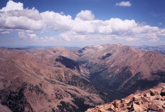
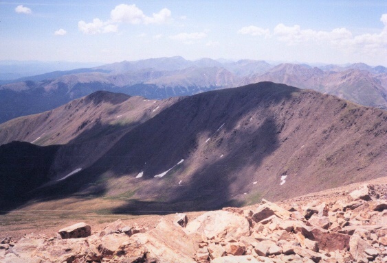
Casco Peak (13,908) and Independence Pass to the west (left). Mount Massive, the second highest in the state across Halfmoon Canyon (right).
After a few switchbacks and quite a bit of elevation gain, the forest begins to thin out. Then there are several open parks. I stopped at one of north-facing parks, which had a good view of Leadville. From here the trees disappear at around 11,500 feet and the tundra continues. I looked straight ahead to see Elbert some 3,000 feet above. I could see other climbers high up on the mountain, which gave me a good idea of the size of this monster. The tundra is beautiful yet there were only a few patches of snow and none of them were close to the trail. This was so surprising because it was only July at the time!
The climb doesn�t let up and continues to be exhausting from here but the majesty of Elbert beckons me to continue on. After a series of switchbacks the trail winds around the south face of Elbert and then makes another series of switchbacks when it is right below the summit. This is the last 400 feet or so from the top. This part is very exhausting as the lack of oxygen begins to catch up to you, even if you live at high altitude. I pushed myself to keep moving, but I did need to pause a few times to catch my breath. Passing climbers on the decent would say, �You are almost there.� I drug myself to the top and summited at around 12:00 p.m.
There was like five people on the top and only a few of them were actually from Colorado. The top was literally awesome. I looked off in every direction at a horizon that spanned more than a hundred miles. To the east I could see the Buffalo Peaks and Pikes Peak behind it in the distance. To the Northeast I could see Lincoln. To the Northwest I could see Massive, and Mount of the Holy Cross behind that. To the West I could see Maroon Bells, Castle Peak, and Sopris. To the South, I could see the collegiates; Harvard, Oxford, La Plata, and many others. I stayed on the summit for two hours, as there were only a few clouds and almost no wind, this doesn�t happen very often in Colorado�s high country. I ate Pringles and roasted peanuts and stuffed myself while enjoying the view. About 2:30, or so, my Dad and I started our decent. We made it down in about an hour and a half. The weather changed very quickly and began to build up as we closed in on the car. It rained on us for like the last � mile.
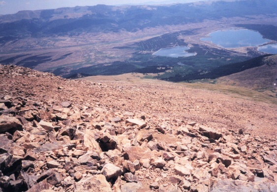
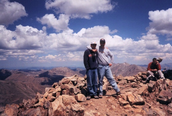
Twin Lakes Reservoir (left). We started from the road by the lake some 5,000 feet below. My dad (Dave) and I on top (right)
 Music Pass July, 2001
 Mount Elbert July, 2002
 Rito Alto Peak July, 2002
 Humphreys Peak June, 2003
 Lakes of the Clouds June, 2003
 Gibbs & De Anza July, 2003
|
 Mount Antero July, 2003
 Comanche & Venable Aug, 2003
 Horn Peak Aug, 2003
 Santiago Peak Feb, 2004
 Agua Tibia Mountain Mar, 2004
 Mount Adams July, 2004
 Shavano/Tabeguache Aug, 2004
|
 Mt Princeton July, 2006
 Engineer Pass Aug, 2006
 Schofield Pass Aug, 2006
 Trail Ridge Road RMNP Sep, 2006
 Torrey Pines SR Dec, 2006
 Mt San Jacinto May, 2007
|
Fill free to email me at [email protected] for questions, comments, suggestions or whatever else you can think of.
Homepage Trip Reports Summit List
