In 1796 Hamilton Kerr and his family from Virginia bought land near the mouth of Leading Creek and started a settlement. The next year, James Smith and family from Massachussets joined them. John Smith was then born in the settlement to Benjamin and Alma Smith, the first recorded caucasian child born in what would become Meigs County.
If you could walk the Leading Creek Watershed with those first settlers, you would observe a totally different watershed than we have today. Based on general stream descriptions of the time, Leading Creek and its tributaries would have flowed clear and clean over sand, gravel, cobble and bedrock in a stream deeply cut into the valley floor. Trees and brush grew right up to the edge and shaded the streams while downed and submerged trees provided cover for fish, which were plentiful, so much so that the riffles seemed alive during spawning.
The first town in the watershed was originally called the Leading Creek Settlement. Its first business was a tavern that opened in 1816. The first brick house in Meigs County was built in settlement in the same year. In 1825 the town got a post office and changed its name to Sheffield. In 1857 the town was incorporated as the town of Middleport.
In 1801 the first school in Meigs County was built on the third branch of Leading Creek by Samuel Denny, a Massachusetts school teacher. The first court was held in a log school at the mouth of Leading Creek.
The first water-powered grist mill in the watershed was constructed in 1805. Damming of the creeks for mills, bridges and the construction of roads formed barriers to fish migration and served to "lock" the creeks in place instead of allowing them to meander.
The practice of dumping sawdust from sawmills into the creek contributed to the asphyxiation of fish and other aquatic species.
In 1820 salt was discovered on Leading Creek. Two years later the first salt well and furnace in Meigs County was opened on Leading Creek. Eight other wells and furnaces soon opened.
Leading Creek and its tribs had a more uniform and sustained flow in the early to mid 1800's due to an abundance of springs that flowed sufficiently to ensure year-round flow in the smallest streams even during dry summers, but more diminished flow was reported as drainage patterns were altered for settlements and agriculture.
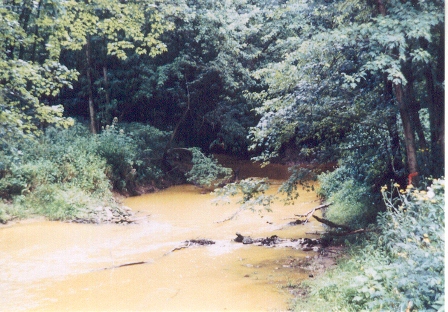
Large scale mining for coal began around 1833 as the forest began to decline and coal was needed for fuel for salt boilers, blacksmiths and later steam engines. The earliest mines were dug in a manner so water would flow away from the working face by gravity, saving the cost of pumping water. This water flowed directly into adjacent streams without treatment. This practice resulted in continuous flow that still impacts the Leading Creek watershed to this day.
By 1900 many of the springs that sustained year-round flows dried up or diminished causing many streams to become intermittent and prone to flash flooding. As a result, many of the mills were abandoned due to insufficient flow. However coal mining, both above and underground continued on, and by this time streams like Thomas Fork were heavily impacted by mining.
Throughout the years, Leading Creek and its tributary streams have been heavily impacted by coal mining with acid-mine drainage from underground mines and sediment from strip mines that poisoned or clogged streams with sand.
Leading Creek was further impacted by the Ohio River when the Gallipolis Locks and Dam caused the Ohio River to back up into Leading Creek, affecting the first nine miles of the stream.
In 1993 an underground mine owned by the Southern Ohio Coal Company (SOCCO) flooded and the partially treated mine water was discharged into Parker Run, killing all aquatic life downstream of that point, a distance of 15.5. miles. The company agreed to a settlement with the federal government which required it to pay damages to the U.S. Department of the Interior. The U.S. Fish and Wildlife Service was put in charge of those funds, referred to as the Leading Creek Improvement Account.
The Leading Creek Improvement Account has provided financial support for projects conducted within the watershed, such as riparian protection and public education. SOCCO also created a 993-acre conservation easement in the name of the Meigs Soil and Water Conservation District. The easement protects land along Leading Creek and its tributaries Parker Run and Malloons Run from development and provides a continuous tract of wildlife habitat.
In 2000, the USFWS and Meigs SWCD established the Leading Creek Improvement Committee (consisting of representatives from state and federal agencies) to provide technical advice on project selection.