 |
|||||||||||||||||||||||||||||||||||||||||||||||
PREDICTING EARTHQUAKES |
|||||||||||||||||||||||||||||||||||||||||||||||
Many of the world's major cities---Los Angeles, Mexico City, Tokyo, Ahmedabad, Shrinagar(Uttranchal) , Kathmandu--are located in earthquake zones. People living there have learned to live with minor tremors. But sooner or later, all of these cities will be hit by a "Big One"----a devastating quake that may claim millions of lives. Seismologists--the scientistswhoise job is to predict earthquakes-now face a race against time. In their quest to find a way to give atleastsome warning, the seismologists are looking to space for help. |
NO CHANCE There is no chance of running away from earthquake. The fastest waves, called P waves, roar along at 3 miles per second. |
||||||||||||||||||||||||||||||||||||||||||||||
PS..... The P(primary) waves arrive first.The slower S(secondary) waves strike seconds later, shaking down already weakened buildings. |
|||||||||||||||||||||||||||||||||||||||||||||||
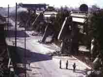
QUAKEPROOF? When an earthquake hit Mexico City in 1985, it was the so called "earthquake-proof" buildings that suffered the worst damage by far! |
|||||||||||||||||||||||||||||||||||||||||||||||
Almost everyday, there is an earthquake somewhere in the world. Most of them occur in an areas known as earthquake zones. Earthquake happen because the Earth's solid outer crust, or lithosphere, is broken into giant fragments called tectonic plates that float on the molten rock below. Earthquake zones lie along the cracks betwen these plates, and earthquakes are triggered by the plates moving past each other. As the plates grind together, the rock on either side of the crack bends, streches and then snaps. This sudden jolts sends shock, or seismic, waves shuddering through the ground to cause earthquakes. The problem with the earthquake prediction is knowing just when the rock is going to snap. In fact, if you live in an earthquake zone and you have not had an earthquake for sometime, expect one soon. The longer the time since the last quake, the bigger the next quake will be. This is because there has been more time for the strain in the rocks to build up. Big quake might occur every century or so, smaller ones every few decades. Scientists now get help from space in making high precision surveys that monitor the risk areas for signs of slight horizontal and vertical movement. The margin for error is still wide, but even a slight increase in accuracy could save millions of lives. UNDER STRESS
One sign of tectonic plates on the move nay be changes in ground water levels, because the stress in the rock squeezes the water upward. A group of Chinese seismologists claim success with predictions based on water levels in wells and boreholes. Another sign may be increased level of radon gas in the ground, forced upward by built-up pressure. Changes in the electrical resistance of the ground, or in its magnetism, may also hold clues. BUILT TO LAST
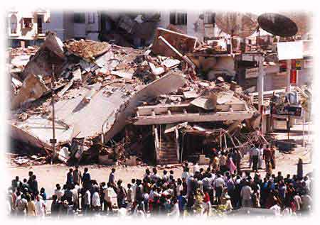
Most deaths in earthquakes are caused by collapsing buildings and roadways. So in earthquake-prone San Francisco and in many Japanese cities, all new buildings must be build to particular safety guidelines. Ideas on the best construction for earthquake resistance differ, but regulations insist on deep, firm foundations of steel and concrete. Wide-based pyramid structures are also encouraged. But even such buildings do not come with guarantee. EARTH MOVEMENT
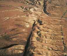
On average, plates slip past each otheran inch or so in an year.In a slip tht triggers a major quake, the plates may move a few yards or more.A major earthquake can easily lift an entire mountain yards in the air. Shallow earthquake originate 0-40 miles below ground. These are the ones that do the most damage. Intermediate earthquake originate 40--180 miles below ground. Deep ones originate 180 miles below. The deepest recorded quake started 450 miles down. HIDDEN FAULT
The worst earthquake disaster to hit America in recent years was the deadly quake that struckwithout warning in Los Angeles suburb of Northridge on january 19, 1994. In just 30 seconds of total mayhem, 11,000 homes were destroyed, dozens of freeways reduced to rubble and and scores of people killed or injured. Yet before the fatal disaster, no one knew of the existence of the branch of the fault line whose suddenly shifting tectonic plates triggered the devastation.
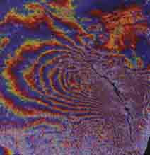
Hard evidence MONITORING THE FAULT
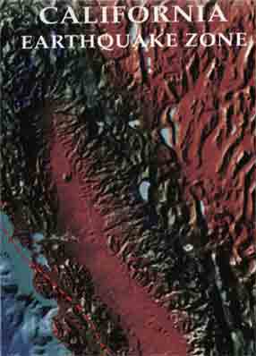
ALONG CALIFORNI'S SAN ANDREAS FAULT, TWO GIANT TECTONIC PLATES ARE SLIPPING PAST EACH OTHER. SINCE THE GREAT SAN FRANCISCO EARTHQUAKE OF 1906, MOVEMENT ALONG THIS FAULT HAS BEEN MONITERED. SOME SECTIONS SHOW ALMOST CONTINUOUS MICROEARTHQUAKES, WHICH RELEASE TENSION. OTHR SECTIONS, SEISMIC GAPS, SHOW NO GAPS OF ACTIVITY. THIS IS WHERE THE BIG ONE WILL OCCUR, AS THE PRESSURE BUILDS UP TO A POINT WHERE IT CAN ONLY BE RELEASED BY A MASSIVE SHIFT. BUT WHEN?
..........Data...........MEASURING EARTHQUAKES There are 2 scales for measuring earthquakes: the Richter and the Mercalli. For the Richter scale, the magnitude of the waves generated by an earthquake are measured precisely using an instrument called seismograph. The scale is logarithmic, which means that an earthquke of 3 on the Richter scale is 10 times as big as one of 2. The biggest Riechert reading yet recorded was 8.9 from the Chilean earthquake of 1960. The Mercolli scale is used to compare modern earthquake with those that ocured before the seismograph was discovered. The intensity of the quake is estimated according to its effects on a scale of 1--12 in Roman numerals. A Mercolli III quake rattles windows; a Mercolli XII brings total destruction.
|
|||||||||||||||||||||||||||||||||||||||||||||||
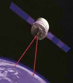
...WE
USED SATELLITES TO DETECT GROUND MEASUREMENTS?
Most seismologists pin their hopes for the future of the earthquake prediction on accurate measurement of ground movements using space technology.There are already 45 observatories in more than 30 countries using lasers and satellites to make amazingly accurate measurements---so precise that they can pick up movements of a fraction of an inch over thousands of miles. These systems work by bouncing laser beams off reflectors on satellites orbiting the Earth and measuring how long they take to return. Toward the end of the century, a linked network of four laser satellite stations called Keystone will come into operation around Tokyo Bay in Japan. A fifth linked station will be airborne. This linked network will be able to track satellite passes and make measurements in earthquake zones over 700 times a month. The system will provide seismologists with more accurate information about ground movements almost instantly. Armed with new technology, the scientists hope to be able to map the slight, but telltale, shifts that indicate an earthquake is on its way. It may not be the best answer, but it is better than nothing.
...WE COULD LUBRICATE THE CRACKS IN THE EARTH'S CRUST? Earthquakes are set off by friction between the rocks on either side of a fault line. Some people argue that we might be able to reduce the severity of an earthquake by injecting lubricating fluids into the fault so that the rock plates slide past each other more smoothly. This could possibly avert the build-up of tension that results in major quakes. In the past, attempts have been made to lubricate fault lines with water and mud. More recently, it has been suggested that the tension could be reduced by forcing the sides of the cracks apart using high- pressure steam.
This is educational material can be distributed for the same purpose. If you have any suggestions / information to share can get in touch with: [email protected] |
|||||||||||||||||||||||||||||||||||||||||||||||
 QUAKE
WATCH
QUAKE
WATCH 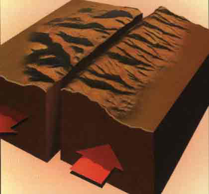

 TRUE STORY