
Last updated: 04/18/07
TRAIL CLOSED!!
|
I went there alone last summer, the trail was in pretty good shape
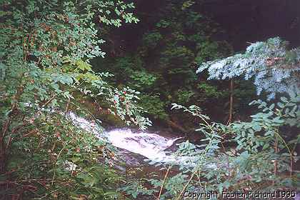
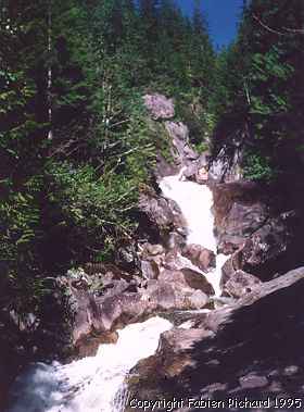
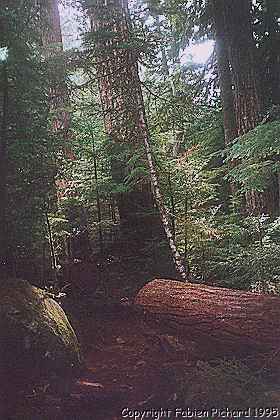
and dry, it was fun. This year, I decided to go there with some friends. I was not disappointed. The trail is fun, challenging because it's very slippery and technical. The MAIN fun was to cross all the creeks! Yes, in the book it's written that you should try it during summer or early fall. We understand now. The creeks were high, very powerful and coooollld... that was Adventure! Trying to find a place to cross the creeks where it was not too deep and not too powerful. At this time of the year, it's not possible to do it alone. We had to help each other to carry the bikes on the top of our heads! Then you realize that having a light bike it a good thing. Right before arriving to the hot springs, there was a pretty wide river to cross. Basically, we had cross where there where trees because it cuts a bit the power of the stream and you can grab a branch to keep your balance. When we passed to the hot springs, we arrived to the Snowqwalmie river... BIIIIGGG river and VERY POWERFUL! we went up stream to try to find a passage where we could cross... NO WAY! So we went downstream, and we found a tree that we could use as a bridge. Unfortunately, we could not walk on it, so we decided to cross it seated and pushing the bike (the chainring helped us a lot to block the bike). That was fun! After, the way back to the car was a piece of cake. I recommend it for everybody! BUT (because there is a but) be ready to 1) Have fun, 2) get wet 3) get tired because it took us 3 hours effective riding to do it. We started a 1:00PM and finished at 5:00PM. 4) have a 4X4, The road to the trail is more for ORV's than for normal passenger cars. If you want to see more pictures of this area, (Jpeg 160k) Burnt boot creek. (Jpeg 116k) Dingford creek 1995. (Jpeg 156k) The path ont he way down from the hot springs. The ride is in Kissing the trail from John Zilly. |
Back to Western Washington's best trails.
|
Here's a description of the Weyerhaueser Tree Farm. This is also the place where the Annual National Multiple
Sclerosis Society Mountain bike ride occurs. The even it well
organized and fun. |
Back to Western Washington's best trails.
|
The place: Elbe - Elbe Hills from
Washington's South Cascade Tom Kirkendall Elevation gain: 800feet Remember how much fun you had when as a child your parents took you to the city park? Well, Elbe Hills area has many of the same elements you enjoyed at the park, only here you take the slides, monkey bars, obstacle courses, and bridges on your mountain bike (Sorry, no ice cream vendor). That's it, it's a plain fun tour! 13 and some miles of rolling hills roots, rocks, steep uphills and downhills and deers will keep you entertained. There is everything on this ride. Even the most technical riders will find some challenges and will have fun! Ok, you will tell me, it's only 13 miles... Well, the last ascent... you will feel it! If you are like me, waiting for the snow to melt and enjoy the looong climbs and the wonderful views, this is the ride to test your technical capabilities and your fitness level. Elbe is located close to Mont. Rainier (paradise). It's about 2 hours driving from Seattle and it worth going. Allow from 3-4 hours to do the trip. Here is a group picture I took... Here is the ride description. |
Back to Western Washington's best trails.
|
Frailey Mountain, Darrington WA.
Washington North Cascade from Tom Kirkendall Elevation gain 2,026 feet, duration 5 hours. The only thing that is required for this ride is stamina. You just climb, and climb and climb for a long time, until you arrive to the top of the mountain, where they launch Hang gliders. It's a beautiful ride on the side of Failey mountain, in fact you go on both side of the mountain, the land is owned by Weyerhauser and so you go through clear-cut. At some points it looks like a war zone. On the other side, you'll have to do some bushbiking through dense vegetation and luckily not too much blackberry bushes, in fact there are enough blackberry bushes to make you bleed like a pig, both arms and legs are scratched. I went there 2 years ago and it was not that dense. If I go back there in two years, I will take a machete to clean up the blackberry bushes... The trip was 1/2 on logging road and the other half on single track. All the logging road part is pretty steep. I mean it's the only part that I would rate skilled. The trick on that ride is that when you think you are done climbing, there is another part to climb, it just never stops. Even the last three miles are rolling hills on pavement (yeah, on pavement...) This ride is a good training if you plan on doing some long one, more than 6 hours. |
Back to Western Washington's best trails.
Kachess Ridge
From John Zilly's Kissing the trail
|
**It's the most beautiful ride I've been**. It was also the hardest
to me. TIP #1: never choose the hard trail with a new bike, ride it
at Novelty hill, adjust everything and let your body getting use to
it. The hike on the first uphill is really hard because you have to carry the bike for 1.5 miles. After that, you will be able to ride the bike. Actually we calculated that on the uphill part, we've been on the bike approximately 60% of the trail. The other 40% was hiking! The last mile uphill, I had to stop 3 time because my legs started cramping. That was awful! TIP #2: NEVER go with new bike on a hard trail!!. The downhill (~ 5 miles) part is excellent, it's on a clear logging road we could go fast (35Mph max speed). At this moment I feel the difference with the shocks, it's really good. In the book it says that it's possible to do it in 4-7 hours. We did it in 5:30 hours (3:10 effective). It's really worth doing it. Even if there is pain. NO PAIN, NO GAIN! |
Back to Western Washington's best trails.
Snoqualmie Tunnel/Iron Horse Trail
|
From: Jonathan A couple of days ago there was a question about the Snoqualmie Tunnel (not to be confused with the caves on Cave Ridge!). The tunnel is on the Iron Horse Trail, part of Iron Horse State Park which was created from the route of the old electrified Milwaukee Railroad. The trail runs from Rattlesnake Lake near North Bend, and then joins up and follows the South Fork of the Snoqualmie. After emerging from the Snoqualmie Tunnel at Hyak, the route runs out to the Columbia River at Beverly. East of that point, the trail stretches on to the Idaho border near Tekoa, south of Spokane. 70% of the route east of the Columbia is in public hands, although I don't recall at the moment under whose jurisdiction. Mileage from North Bend to Rattlesnake Lake is about seven on an abandoned railway bed. Mileage from Rattlesnake Lake to the western portal of the tunnel on the Iron Horse is just under twenty, if I remember correctly. Somewhere around Ellensburg the right-of-way is dubbed the John Wayne Trail. Iron Horse State Park is popular with bikers, walkers, equestrians, cross country skiers and even dog-sledders! The railroad was last used in the 1970s, then abandoned and the rails and ties removed. A few years ago they fenced off the tunnel. One could still slip past the fence at the western end, but if the eastern doors were shut, you had to walk back the length of the nearly 2 1/2 miles to the western portal. Now it's open and graded, ez walkin' or bikin'. It's dark and chilly, but quite an experience! The quickest walking access to the Snoqualmie Tunnel is from the Annette Lake Trail, a few miles west of Snoqualmie Pass, I believe that's exit 47. From the Annette Lake Trailhead, the tunnel is about 2 1/4 miles, a nice walk through second growth forest, rising to the unpaved railroad right-of-way, which yields great views up and down the South Fork of the Snoqualmie River. Check out John Zilly's description of the route in "Kissing the Trail," a popular mountain biking book available at REI and other outdoor gear stores. Permits are required to use the section called the John Wayne Trail, but I don't know at what point along the right-of-way permits become necessary. It's east of Easton in any case. There are phone numbers in Zilly's book you can call for information and permits. Fred Wert's "Guide to the Rails-to-Trails of Washington State" provides a more extensive list of phone numbers and addresses for trail information, as well as an interesting primer on the rails-to-trails conversion process. One more thing, clear cutting the slopes of Hall Creek, about 10 miles west of the tunnel, let loose landslides that destroyed one of the trestles a few years ago. It's necessary to leave the trail via a wide gravel road about seven miles east of Rattlesnake Lake, ride a section of old US 10 and then take a right at the end of this section and ascend to the Iron Horse again. There are a couple of other routes back up again, peruse the description in Zilly. The Iron Horse, like the Snoqualmie Valley Trail and the Burke-Gilman are rail-trails, multi-use public rights of way that are created when a railroad is abandoned and the land is rail-banked or otherwise turned over to the public trust. The non-profit Rail-to-Trails Conservancy has been instrumental in creating over two thousand miles of trail in the United States along abandoned railway. These corridors might have been otherwise lost to a few adjacent land owners and corporations, depriving us and future generations of Americans of linear parks hundreds of miles of long. The conservancy's goal is " . . . to enhance America's communities and countrysides by converting thousands of miles of abandoned rail corridors, and connecting open space, into a nationwide network of public trails." Rails-to-Trails Conservancy 1400 Sixteenth Ave, NW Suite 300 Washington, DC 20036 Phone: (202) 797-5400 Fax: (202) 797-5411 |
Back to Western Washington's best trails.
|
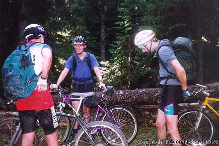
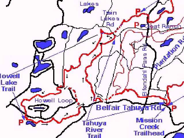
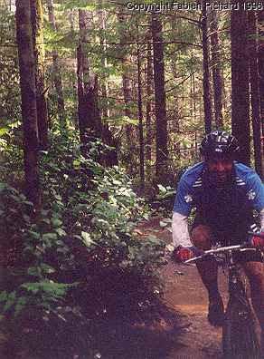
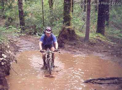
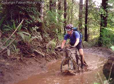
From: Fabien, Alan, Peter, Xavier Sent: Monday, May 20, 1996 1:21 PM Fun, water and mud! 3 words to describe a super ride, "But we are in Washington state, what's different?" you will say. Well, not so many roots and a LOT of water!!! I thought I needed fins. Long, large and deep mud puddles, nice short ascents and quick technical descents make this ride really worth doing. It has only 250 feet of elevation gain for 12.5 miles, but make you wonder when it stop. Your legs will be wasted anyway... This is a good ride to get in shape for later SERIOUS ride during the season. It is a fun ride for spring or fall season, it will be hell on water during the winter and too crowded during the summer. Yes this is an ORV trail, so watch out for the motorcycles and ATV's... Bummer! Too many of them! Interested? print out is the map (PDF format). Access: Drive to the town of Belfair at the tip of Hood canal an follow the signs towards Belfair State Park. Take the North Shore road (hwy 300) west for 1.1 miles. Turn right on Sand Hill rd. Take a left at 2.8 miles on Goat ranch Road at a large gravel pit. Follow the road until you cross a paved road (Elfendal Pass road). Continue straight and pass a camp on your right. Pass Twin lake road and turn right in the direction of the Tahuya campground. Park in the campground. Our ride was this one, I modified the original map to be able to see where we went. What we did in Tahuya. Do you want to see some pictures? (155k) Alan smiling on the Trail. (162k) PeterW and Xaviers crossing a lake. (163k) PeterW crossing a mud puddle (162k) and a series of XavierS pictures crossing various mud puddles. |
Back to Western Washington's best trails.