| Goin' Down the Delta |
 |
 |
 |
 |
 |
 |
 |
 |
 |
 |
 |
| "Hey, I'm going down to the end of the road, you want to come?" Without asking which road I agreed it would be a good idea. Then, I hit "reset" realizing who I was talking to, and asked, "which road"? Ray Fagon, Mississippi and Alabama micro-tourer* was presenting a plan for us to meet east of the Rigolets** and ride down to the end of the legal road following the levee down the east side of the Mississippi River. The River is not just a stream of water in Louisiana and Mississippi. It is the axis of so much history and the center of much of our commerce as well as that of much of the country. It is also a very powerful natural force. Awing in appearance and magitude. It is magnetic for those who enjoy being around power. Pure undiluted power. Seeing it where it worked and was its most powerful could not be passed up. So. I agreed. |
| The Ridgolets |
| The following is a brief discription of my ride to meet Ray. I got lost in Abita Springs. I got lost in Slidell. I looked for a road I thought existed. I could not find it. I found out it did exist. I back tracked through Slidell traffic. I got on the hated I-10 in a metropolitan area. Am I crazy? I arrived exactly on time, 9:30 AM, at Mc Donalds, Slidell, Louisiana. I did not sit down with a gestering Ray. I was frustrated and wanted the trip to get fun. I'd been riding since 7:45 and had logged 65 miles on a trip that should have been 45 or 50, and that many minutes. The site moto contains "Lost and Loving It". I'm thinking that one over. |
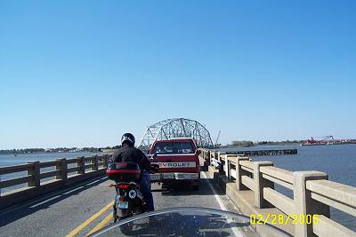
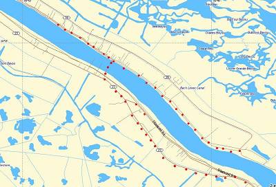
| Above, the red dots trace our trip. No way to get lost here. Good thing. We rode out of Slidell on US 90, that proud old road. Below, we are on the Rigolets Bridge waiting for the the turntable, ahead, to get back into position after letting a boat through. Notice how narrow the bridge is. You do not want to drive your RV across it. The speed limit is 25 miles an hour and for once in Louisiana, a speed limit is obeyed. The story on the bridge is this, I think. It was built by Huey Long who wanted to put a political enemy out of business. The enemy had built a Toll Bridge across Lake Pontchartrain a little further east. Huey put him out of business. Huey put a lot of enemies out of business. |
| Above is Ray on his scooter. |
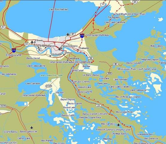
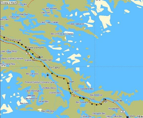
| We rode past Fort Pike on the Rigolets** and past all the camps that line US 90 heading into New Orleans. When we got to I-510 we turned and crossed the Intracoastal Canal on its high bridge. I would have loved to have gotten a shot from its heights, but I was busy putting indentions into my hand grips. The wind always blows on top of that thing. We rode 510 to its end and then into Chalmette and tuned east when it ended, meeting La.39 shortly. We rode 39 until we could get onto the levee road and then rode it to its uncelebrated end south of Pointe a la Hache. I went up on the levee to see a glorious vision. There was Nothing Special. Just more levee. It took off down the river. I don't think that levee had much more work to do and does end pretty quickly. We headed back to Pointe a la Hache***.. |
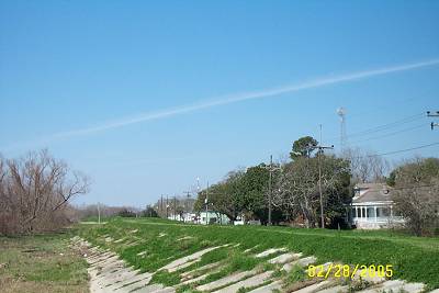
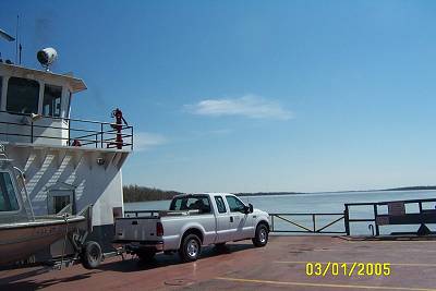
| We climbed the Levee to catch the ferry. Of course it was on the other side of the river. I turned and looked down the levee. What I saw is why I'm coming back. There is so much great architecture on this side of the levee. I think I could spend a whole day seeking it out and shooting what's left down here. This was a recon mission and I wouldn't do that to a co-rider. Photography is a lone sport. |
| End of the line. |
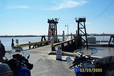
| Ferry |
| The Old Man awaits us. Hope he's in the mood for company. |
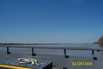
| The natural weekend appendage to any Louisiana car/truck is a boat. |
| The ferry man directed us to bow parking, a pretigious appointment. With the wind in our faces we departed the landing and made for the West Bank. By the way, we were given complimentary boarding passes. OK, its free. Both ways. |
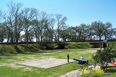
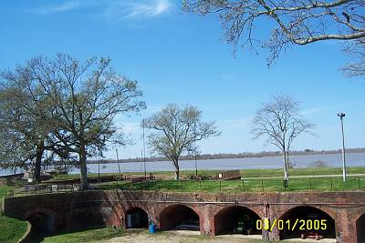
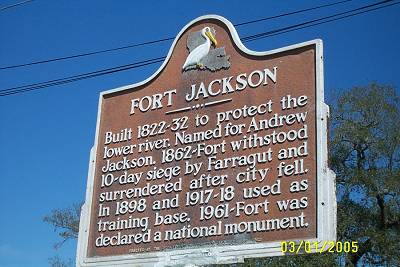
| Disembarking the ferry, we joined La.23 and rode and rode and rode. It is not good riding. This is the road to Venice. The end of the line and jumping off location for a lot of oilfield workers for many years. It is sometimes four lane, sometimes two, going through a few towns. Oranges are grown down here, also. At Buras I was getting Sore Butt anticipation. Not that I had SB but knew it would be a factor if we prolonged this search for The End of the 'World on this side of The River. I wanted to see something and at about that point, shortly after Buras, Fort Jackson presented itself. I thought the entrance was to a football field, It was, my heart sank. I thought they had plowed down the fort for a highschool football field. There the field was. But, the road continued, and behind the field, there stood the mighty defender in all its glory. If you have been to Fort Pike on the Rigolets, the constuction is very simular. The fall of this fort and her sister fort across the river, spelled the beginning of the end for the South's South during the Civil War, allowing the Cofederacy to be split in two. New Orleans fell shortly afterwards. It cost nothing to enter the fort and there are friendly people there to assist you in your visit. Unfortuately the museum was not open. |
| Above is the center of the fort. |
| Best shot of the trip. Standing in the exact same place where so much history occurred does bring on reflection. Then you reflect on where you are and how tentative this place is in modern times and how much more tentative it was in the past. What was not tentative was our distance home unless we got on the road. It was after one o'clock and we were getting a bit hungry. Ray likes restaurants, so I forsook my usual peanut butter sandwitch and joined him at the trough, I mean cafe. About 4 o'clock we left and got some some gas. For the bikes. We crossed the ferry, again receiving our complimentary parking. We exhited behind a diesel school bus and followed it for thirty miles until somewhere in Chalmette. The ride was trying. I learned that if I wanted those pictures of the old architecture it would take a commitment. I get committed often so no problem there. Below is a little history on the Fort. I'll find some links and place them below the picture. It is worth the ride. Like Ray said, "We can check that one off". Checking stuff off is important, do it. |
| There's a lot more information out there, but these sites should give you an idea of the importance of that old fort behind the football field. More Louisiana, Mississippi and Arkansas can be seen by hitting that "Next" button. |
| * Micro-tourer, tourers who look closer over a smaller area. Fagan mentioned the term so I'm not accepting responcibility for any copyright violations. |
| Fort Jaskson |
| This one was interesting to me in that the area you guys rode from the Rigolets to the Intercoastal Waterway high rise bridge and out to I-10, US 11/Irish Bayou area was my police beat at one time! The word **"Rigolets" comes from a corruption of the French word "rigole" meaning "trench" or "gutter". The Rigolets is a deep, swift channel between the Gulf of Mexico and Lake Pontchartrain with a tidal curent that rushes in and out each day. Jayne Mansfield died in a fatal vehicular accident along this stretch of U. S. 90 at a spot near Lake St. Catherine known as "Dead Man's Turn" (Also called Green's Ditch). ) I don't know if you guys noticed it, but at Pointe a la Hache there's a sort of primitive camping area at the very end of Highway 39 near the Beschel Hoist/Marina and a canal leading back to Breton Sound. ***Pointe a la Hache means "Point of the Hatchet" or tomahawk. Word on the street is that explorers found an Indian tomahawk embedded in a tree there marking some sort of boundary way back during the LeMoyne Brothers' day. |
| Henry from New Orleans, aka "copcop", has again added to one of my loosely organized and researched articles. Thanks, Henry. If you are wonder about "The Rigolets" and the meaning of Pointe a la Hache, he covers that plus more. His note is below. |
|
|
