|
Tourist Locations in West Bengal |
| Digha | Diamond Harbour | Sunderban Wildlife Sanctuary | Piyali Bakkhali | Krishnanagar | Murshidabad | Bagnan | Dooars | Gadiara | Mirik Haldia | Barrackpore | Chandannagar | Bandel | Darjeeling | Jaldapara Wildlife Sanctuary | Kalimpong | |||||||||||||||
|
|||||||||||||||
51 Km from the city is the old port of Kolkata (Calcutta). From here Hooghly turns south to merge into the sea. From here one can take launches to Sagar island for the famous Ganga Sagar Fair. |
|||||||||||||||
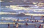
Bakkhali possesses a beautiful beach lined with Casuarina groves. At Bakkhali, the beach is long and sandy, the waves twinkling in the sunlight. Dense casuarina groves drape the beach. Red fiddler crabs march in line on the beach. It is so near Kolkata (Calcutta) and yet so very different from the bustling metropolis that is Kolkata. Bakkhali is only 132 km from Kolkata. From Kolkata to Namkhana by bus (105 km), then a short diversion by the ferry across the Hatania Doania river, and then another hour and a half bus journey to Bakkhali. En route, there is Diamond Harbour (48 km from Kolkata) where there is a comfortable Tourist Lodge for accommodation. |
|||||||||||||||
Krishnanagar is famous for its toy and clay models. Ghurni, on the banks of river Jalangi is where the clay modelers produce and sell their artistry. The Krishnanagar Palace is also famous. The Roman Catholic Church at Krishnanagar is another attraction. Sweets like Sarpuriya and Sarbhaja are Krishnanagar specialties and are no less famous than the clay images. Krishnanagar is conveniently connected with Kolkata both by rail and road. By rail it is 100 km. The town is 3 km From the railway station. By bus it is 118 km On NH 34. Within the town, city buses as well as cycle rickshaws are available for transportation. For accommodation there is the Krishnanagar Municipal Tourist Lodge. There are a number of private hotels also near the bus stand. During April every year, Barodol is celebrated in the premises of the Krishnanagar Palace. From Krishnanagar one can easily visit Nabadwip, Mayapur, Santipur, Fulia, and Bethuadahari. |
|||||||||||||||
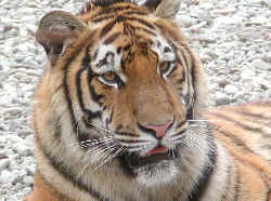
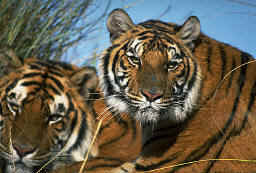
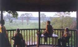
Sundarbans is a vast tract of forest and saltwater swamp forming the lower part of the Ganges Delta, extending about 160 miles (260 km) along the Bay of Bengal from the Hooghly River Estuary (India) to the Meghna River Estuary in Bangladesh. The whole tract reaches inland for 60-80 miles (100-130 km). A network of estuaries, tidal rivers, and creeks intersected by numerous channels, it encloses flat, marshy islands covered with dense forests. The name Sundarbans is perhaps derived from the term meaning “Forest of Sundari”, a reference to the large mangrove tree that provides valuable fuel. Along the coast the forest passes into a mangrove swamp; the southern region, with numerous wild animals and Crocodile infested estuaries, is virtually uninhabited. It is one of the last preserves of the Bengal tiger and the site of a tiger preservation project. For six thousand years the rivers Ganga and Brahmaputra, carrying millions of tonnes of silt, gifted the world this unique mosaic of 54 islands. In the early 16th century the Ganga changed its course eastwards; taking with it the fresh-water flow. The western Sundarbans became vulnerable to the back-lash of the Bay of Bengal, coverting the rivers of this area into a labyrinth of tidal channels and creeks. The face of Sundarbans changes dramatically with the diurnal tides. The forests are in perpetual flux. At peak high tide, more than half the land is submerged. The forests float. Life is sustained by a dynamic cycle which begins with the waxy mangrove leaves. These fall into the water and are the base of the ecological pyramid with the mighty tiger at its apex. As the water recedes, the forest floor reveals the many mysteries of this precious biosphere. The multilayered mud banks unfold their strange and bizarre beauty. Pneumatophores (breathing roots) stand bayonet-like. The arched and tangled stilt roots sometimes present a grotesque picture. Foreshore grasslands of wild rice (Oryza coarctata) are uncovered. Beyond, hang the dense tidal swamp forests defying penetration. Here nature red in tooth and claw is both wild and wonderful. The evergreen abode of the world's most luxuriant mangrove vegetation in the Sundarbans is also the home of the biggest colony of Royal Bengal Tigers (Panthera tigris). His ferocious majesty has left tracks even on Himalayan snows at 10,000 ft. Here, below sea level, one may see fresh pug-marks on the glistening mud flats of the largest global estuarine delta. But it is difficult to spot the ever elusive undisputed mighty monarch of the jungle. Somewhere in the elegant clumps of green and yellow Hental Palm (Phoenix paludosa), the tiger, as the saying of the Sundarbans goes, is always watching you. The mangrove eco-system is an aquaterrestrial system where food chains of both land and water are interlinked. Tigers (Royal Bengal Tigers) are the biggest predators of the Sundarbans, occupying the foodweb pinnacle of both the aquatic as well as terrestrial eco-systems. The cat fish, predatean scally fish are preferred food for Crocodiles and Water Monitors (salvator lizard) and palatable food for tigers. Tigers also feed on fish, crabs and turtles, apart from it major terrestrial prey animals like wild boar, spotted deer and monkeys. Thus, the preservation of tigers in the Sundarbans could take care of the entire gamut of plant and animal life of both the forests as well as the creeks. The pristine beauty of nature is made alive by the variety of the flora and fauna. It is one of the world's prized wetlands. The Keora (Sonneratia apetola) occupies pride of place and is easily identified by its stately height. The increased salinity of the water has reduced the great Sundari to a mere shadow of its former glory. In April-May, the flaming red leaves of the Genwa (Excoecaria agallochia) edge the emerald islands. The single crab like red flowers of the Kankra (Bruguiera gymnorhiza) and the yellow blooms of the Khalsi (Aequiceras corniculate) add to the dazzling display. The Garan (Ceriops decandra), the Garjan (Rhizopora mucronata), the Dhundul (Xylocarpus granatum), the Baen (Avicennia marina) etc. make up the littoral forest. The short stemmed Nipa Palm (Nipa fruticans) bears one of the few edible fruits. Viviparous germination ensures that life continues in this fragile eco-system. All around a myriad fascinating life forms awaits in this vast alluvial archipelago. The Royal Bengal Tiger once ruled this special ambience and the Sundarbans, and this area was a paradise for tiger hunters. But the rapid fall in the Royal Bengal Tiger population forced the government to declare tiger poaching as illegal and the area came under the Project Tiger. The Sundarbans Tiger Reserve in West Bengal, demarcated over 2585 sq kms, stretches a little south of the Tropic of Cancer. The reclaimed populated islands of Gosaba, Hingalganj, Sandeshkhali and Basanti form the northern boundry; on the south, the sea; to the west, the Matla and Bidya rivers and to the east, the international boundaries of Bangladesh. The core area of 1330 sq kms has been declared a National Park and has been chosen as a world heritage site. The tiger in the Sundarbans is the only one of its kind to live in mangrove swamps. This magnificent beast has adapted to the inhospitable habitat. Tigers in Sunderbans are known to swim a record distance of 10 kms. On the treacherous pneumatophore spiked quick-sand-like bank, it covers 24 kms an hour. They also hunt fish if hungry or steal honey from the bee hives. Though Sunderban tigers are described as man-eaters, specialists say they rarely attack human beings. Tigers are not the only attraction in Sunderbans, there are estuarine crocodiles and shy jungle cats or the fishing cats. The reptiles found in the forest includes the King Cobra, Rock Python and Water Monitor. During the winters the Olive Ridley Turtles descend to nest the shores of Kanak island. The tigers can be easily spotted at the water holes at Sajnekhali, Sudhanyakhali, Netidhopani and Haldi. No permission is required for a general river cruise outside the core area and sanctuary. But there are particular places where permission will be required. The annual congregation of nesting birds from July to September makes Sajnekhali Bird Sanctuary an orthologists paradise. It is then that besides the residents, waders like Plovers, Lapwings, Curlews, Whimbrels, Sandpipers etc. and occasional Pelican appear. Moreover there are large Egrets, Lesser Adjutants, Kingfishers, Cormorants, Brahminy Kites etc. Besides birds there are Red Fiddler Crabs, MudSkipper Fish, Hermit Crab, and the Estuarine Crocodile. There are the rare Horseshoe Crab and Gangetic Dolphins and the Black finless Porpoise. There are Fishing Cats, Jungle Cats, Wild Boars, and Spotted Chital Deer. There is an innumerable variety of reptiles including the king Cobra, the Rock Python and the very rare Olive Ridley Turtles on Mechua Beach. The best time to visit Sunderbans is during winters between September and March. There are regular bus services from Kolkata (Calcutta) to this place. But the main areas of the sanctuary can only be accessed only by riverine waterways. The best and the safest way to visit Sunderbans is on conducted tours. One can also avail the services of the private vessels from Canning, Gosaba or Basanti. Accommodation in the sanctuary is available, in the comfortable tourist lodges. Sajnekahli has a 60 bed tourist lodge. Overnight facilities are also available at Bakkhali and Piyali. Some of the places of interest are: Gosaba - Sir David Hamilton’s settlement, Sajnekhali - Bird sanctuary, Bhagabatpur - a crocodile hatchery cum sanctuary, Netidhopani - the ruins of a 400-year-old temple and legends lend mystery to the atmosphere, Haliday Island - last retreat of the Barking Deer (Muntiacus muntjak), Kanak - nesting place of Olive Ridley Turtles. |
|||||||||||||||
Gateway to the Sundarbans. 72 kms from Kolkata (Calcutta) by road and close to Sajnekhali, Netidhopani through waterways. A small river Piyali flows through green paddy fields and mingles with the river Matla. Picturesque Piyali delta is ideal for a quite romantic holiday. A beautiful tourist complex with accommodation and recreational facilities is coming up shortly on 100 acres of velvet green. |
|||||||||||||||
This is the new port of Kolkata (Calcutta) and is 96 km south of the city. This place was developed as port to avoid the silting problem in the Diamond Harbour. Today the Haldia Refinery has added value to the place. There are regular bus services to both the ports from Kolkata (Calcutta). |
|||||||||||||||
25 kms from Kolkata (Calcutta) is a place which was the cantonment of the East India company. Today not much is left of that cantonment but the place has acquired a historical significance. The gardens along the river bank are very nicely laid and are very charming. The Gandhi memorial attracts a large number of tourists. Barrackpore was one of the places which was transferred by the Danish settlement to the East India in 1845. |
|||||||||||||||
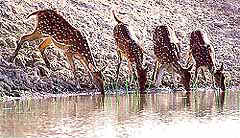
Lying in the Himalayan foothills, Dooars has great natural beauty. The wildlife-rich tropical forests, innumerable hill streams cutting across the green carpet of tea gardens and undulating plains, low hills rising up from the rivers. A drive through the Dooars plains, the gateway of Bhutan, can be a lifetime experience. The Dooars valley stretching from River Teesta on the west to River Sankosh on the east, an area coving roughly 130 km by 40 km, the Dooars forms major part of the Jalpaiguri district. The name Dooars is derived from the ‘doors’ as the region is the gateway to the entire north-east India and Bhutan. Dooars is also the gateway to the hill stations of Darjeeling Sikkim region. Dooars is famous for its rich biodiversity and forests. The most notable of which are Gorumara National Park, Jaldapara Wild Life Sanctuary and Buxa Tiger Reserve. |
|||||||||||||||
The French trading post was handed over to India along with Pondicherry in 1951. The French settled here in 1673 and made it their trade center. But they lost this place to the British in a conflict. Today this place along the river Hooghly has some buildings of the French era and is now famous for the artisans who make clay figurines. Chandernagore is 39 kms from Kolkata (Calcutta). |
|||||||||||||||
43 kms from Kolkata (Calcutta) is a site of Portuguese church and monasteries which were built in 1599 and were destroyed in 1640 by Shah Jahan and were rebuilt. |
|||||||||||||||
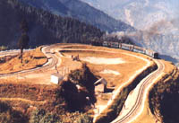
Darjeeling the Queen of the Hills has the highest Race Course in the World. Darjeeling the Dream Land of the East, it has been a popular hill station since the British period. The tourist flow to this place has been increasing day by day. Due to the proximity with three international borders, this place is strategically very important. Darjeeling is surrounded by lofty mountains. Except for the monsoon months and if weather is clear then the Kanchenjunga peak can be seen. Down below in the valley flow the rivers swollen by rain water or melting snow. Darjeeling is a fascinating place rich in natural beauty and surrounded by the Buddhist monasteries. Its beauty surpasses any other hill station. Darjeeling has some of the lovely tea plantations (estates) in the country. One can visit these plantations and watch tea being processed. Darjeeling is a place where one feels as if being in the lap of mother nature. Due to the vast and abundance of natural splendor, Darjeeling is called Queen of Hill Stations. Darjeeling is also a trekkers paradise and the Gorkha hill council has provided ample trekking facilities for the adventure loving people. Situated at an altitude of 2590 m (8,482 ft) and 11 km from the town, the Tiger Hill has earned international fame for the fabulous view of the Sunrise over “Kanchenjunga” and the great Eastern Himalayan peaks that can be seen from here. On a clear day even Mt. Everest is visible. The golden glow of the rising Sun changes the colour of the snow capped peaks to crimson, pink and shining gold as one watches from the observation desk. Like many places in the Himalaya, half the fun is in getting there and Darjeeling has the unique attraction of the famous Toy Train. Commissioned way back in 1881 this quaint narrow gauge Darjeeling Himalayan Railway, affectionately called the ‘Toy Train’, is definitely the first choice of all nature lovers visiting Darjeeling. The toy train coming from New Jalpaiguri is some thing which is liked by the elders and the children equally. The real fun in coming to Darjeeling is on the toy train. It takes six to seven hours to cover a distance of 82 kms and the slow speed gives you enough time to watch and appreciate the beauty which nature has provided it. This miniture train loops and switchbacks its way up the steep mountainsides from New Jalpaiguri to Darjeeling. This train passes through the forests, waterfalls, over deep valleys and through the mountains and tunnels. The Batasia Loop is about 5 km from Darjeeling and 3 km from Ghoom. This railway loop is a marvellous feet of engineering. It is delightful to see the trains as it winds it away round the loop. It is a pleasant and delightful descent from Ghoom - highest railway station in the world. The Mall is an important meeting point for all tourists. Restaurants, Cafetarias, and shops full of woolen goods and curious are main attraction. The view of Kanchenjunga from here is marvellous. The Darjeeling - Rangeet Valley Passenger Ropeway is situated at North Point which is 3 km from the town. This is the first passenger Ropeway in India. It is 8 km long and connects Darjeeling and Singla Bazar. Some must see places in Darjeeling are Jawhar Parbat (formerly Birds Hill), Padmaja Naidu Himalayan Zoological Park, Lloyds Botanical Garden, Rock Garden, Ghoom Buddhist Monastry, Observatory Hill, Dhirdam Temple, Japanese Pagoda, Dali Monastry, Aloobari Monastry, Bhutia Busty Monastry, Himalayan Mountaineering Institute, Tenzing’s House, Tiger Hill, Batasia Loop, The Ropeway, The Mall. For mountain views, the best time to visit Darjeeling is from mid-September to mid-December, although it gets pretty cold by December. The season resumes around mid-March and continues to mid-June. |
|||||||||||||||
A small but bustling town in the Himalaya foothills of West Bengal- Kalimpong is at an altitude of 1250 meters. This bazaar town was originally a part of Bhutan but later it was taken over by the British and finally it became a part of West Bengal. Kalimpong is famous for its monasteries, Churches and a private library for the study of Tibetan and Himalayan languages, culture etc.. This place also has the Sericulture centre and the orchid nurseries and of course the place provides some beautiful sights of the Himalayan range. Though not all travelers visit this place which demands some attention. The journey from Darjeeling along the Teesta River is very interesting. |
|||||||||||||||
Murshidabad named after Nawab Murshid Quli Khan, the Dewan of Bengal, Bihar and Orissa under Emperor Aurangzeb, is intimately related to events that ultimately changed the history of India. At Plassey near Murshidabad was fought the historic battle between Nawab Siraj-ud-Daula and Lord Clive. The relics strewn today speak of those times. But the history of this region dates back perhaps a little further. The travelogue describes Karnasubarna near Murshidabad as the first capital of ancient Bengal. Murshidabad silks are still famous. Ivory carvings of Murshidabad are the pride of Bengal’s handicrafts. |
|||||||||||||||
Mirik, a new hill station near Darjeeling, has a 1.25 km long lake, the Sumendu Lake, the major attraction of Mirik, at the bottom of Mirik spur. There is a floating fountain in the middle of the lake and a quaint little footbridge connects the flower garden on the eastern bank to the heavily forested ridge on the west. The lake is provided with boating facilities. The arch bridge across the lake is 80 ft long. Rameetay Dara is a viewpoint from where one can get a sweeping view of the plains and the mountains. Sunrise and sunset seen from this point are unforgettable sights. Deosi Dara is another observation point offering a panoramic view of the plains, the hills and the peaks. Rai Dhap is an ideal picnic spot. It is the source of drinking water for the whole of Mirik. |
|||||||||||||||
The Temple of Madangopaljiu in the Mellak village is of considerable archaeological interest. Built in 1651 AD, the temple contains early specimens of terracotta art. |
|||||||||||||||
Away on the banks of the River Hooghly, this small village is located near the confluence of the Damodar, the Rupnarayan and the Hooghly rivers. Gadiara commands a magnificent view of the three mighty rivers. Here the combined body of water is so vast that it looks like a miniature sea. Nature at Gadiara, despite its lack of variety, is quietly beautiful. |
|||||||||||||||
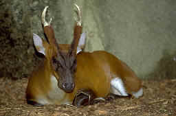
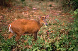
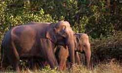
The main attraction in Jaldapara apart form its exquisite natural beauty, is the Asiatic one horned rhino. The Jaldapara sanctuary holds the maximum number of rhino population in India after Kajiranga National Park in Assam. Among other major attractions, the elephant, Indian bison, Royal Bengal Tiger, leopard, spotted deer and hog deer can be seen here in plenty. Jaldapara is a paradise for bird watchers. It is one of the very few places in India, where the Bengal Florican can be sighted. Set out with a binocular and see the majestic flight of lesser Pied hornbill, racket-tailed drongo, paradise flycatcher, Crested Eagle, Pallas's Fishing Eagle, shikra, Jungle fowl, peafowl, partridges and many other bird species. An adventurous elephant ride in the morning will take you deep inside the grassland for the real excitement. The sights of rhino in a muddy pond, the herd of elephants or the running deer are the thrilling experiences in Jaldapara. Jeep safari insight the forest is also organised on a regular basis. Totopara, adjacent to the Jaldapara sanctuary is a major attraction for those interested in ethnic tourism. Totopara is the only settlement for the Totos, one of the most endangered ethnic communities in the world. Their numbers are now reduced to mere a thousand. Lot of initiatives has been taken by the governmental and non-governmental agencies for the uplifting their living condition. However, to live with them and to observe their traditional cultures can still be a precious experience. Hidden deep inside the Chilapata Forests the ruins of a thousand yeas old fort of Nal King has a tremendous historical and archeological importance. Built in the 5th century during the Gupta Empire the ruins still recall the memories of the Golden Age. Because the site is not maintained properly, it has now become the playground for leopards, snakes and other animals. Other destinations of Dooars like Gorumara, Mahananda, Neora, Buxa, Chapramari, Murti, can also be visited from Jaldapara on a day trip. During the rainy season the sanctuary remains closed to tourists. Time - June 15 to September 15. Outsiders can visit the forest only during visiting hours from 9 AM till 4 PM. |
|||||||||||||||