This pamphlet is the first in a series answering agricultural question.
What is the true cost of production
?The accurate value of the land must be determined in order to find the cost of production. Determining the accurate value requires a system that deals only with the relative land value. This system requires understanding three points,the soil type, Corn Suitability Rating, and interpreting the information. Agronomy 2000 puts this information into a productive format.
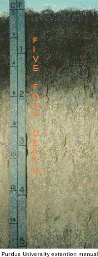 |
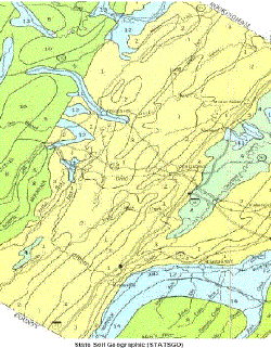
The soil type is determined by the U.S. Department of Agriculture’s (USDA) Natural Resources Conservation Service (NRCS), formerly Soil Conservation Service (SCS). This agency is responsible for collecting, storing, and distributing soil survey information for privately owned lands in the United States. The picture to the left shows the five-foot depth of the soil survey samples. The Natural Resources Conservation Service (NRCS) has three soil geographic databases. The geographic databases are the Soil Survey (SSURGO) database, the State Soil Geographic (STATSGO) database, and the National Soil Geographic (NATSGO) database. Components of map units in each database are generally a soil series that enables the most precise interpretation. Interpretations are displayed differently for each geographic database to be consistent with differing levels of detail. The database contains physical and chemical soil properties for approximately 18,000 soil series recognized in the United States. The State Soil Geographic (STATSGO) database for agriculture further divides different conditions in each soil series.
|
Data for each soil series include:
Particle size |
Soil reaction |
Soil subsidence |
Site development |
Crops |
Salinity |
Water table depth |
Water table depth |
Depth to bedrock |
Organic matter |
Water capacity |
Management |
Agricultural Soil survey publications are widely distributed. Soil publications cover the local area intended. A county area for agriculture is the normal extent of a publication. Published soil surveys are available in libraries of most universities and colleges in the United States and in libraries of many towns and cities. In addition, agricultural colleges, ministries of agriculture, and libraries in many other countries have the complete State Soil Geographic (STATSGO).
Finally, a soil series history provides an insight to the soil’s fragility. The history enables the Natural Resources Conservation Service (NRCS) a scientific basis to analyze management techniques. The nature and detail of the maps make it feasible to repeat the soil series every fifty years, an unprecedented short time to in geological terms.
Interpreting the information requires a detailed location of recently sold land in the area and the land in question. Establish the corn suitability rating of land recently sold in your area. Obtain the value of one corn suitability rating by dividing the price per acre by the corn suitability rating of the recently sold land. Apply the new value to the corn suitability rating to the land in question. The accurate value of the questioned land is the calculated amount.
The intention of the Department of Agriculture is to make this precise information affordable and practical to the general public. Computer software developed by the Natural Resources Conservation Service (NRCS) to achieve the intended task has only a narrow application. Most counties’ Farm Service Agency uses the software to facilitate federal farm programs. The public can purchase the computerized Natural Resources Conservation Service (NRCS) database maps by county at a cost of fifty dollars each county. There also is the initial cost of purchasing the interpreting software, and special hardware.
Agronomy 2000 developed a simple inexpensive solution to this situation. Soil survey maps and corresponding corn suitability ratings are available in the Iowa State Library. Agronomy 2000 has developed a computer system to analyze the land in question.
Provide Agronomy 2000 with the exact location of the land in question. In addition, the location of land recently sold in your area is required. The locations need to have the State, County, Township, township section and the out lined property. Agronomy 2000 can find the accurate value of the land or help with other management needs.
56A Schilletter Village
Ames, Iowa 50010
515-572-4101
Last update 01/04/04
![]()