
William Austin Burt, of Mt. Vernon, Michigan, had been appointed a Deputy Land Surveyor for the Federal Government in 1833. In 1834, he surveyed an area north of Milwaukee in Wisconsin Territory. The area had local magnetic attraction causing great difficulty in surveying for Burt and other surveyors. In 1835, he worked on a model of his solar compass, then referred to as a "variation apparatus" or "variation compass." Variation referred to the amount of difference in degrees between true north and magnetic north. On February 26, 1836, he received patent number 9428X for his invention. It was first used that year by him and by his son Alvin, also a surveyor. Here was his original device attached to the standard field compass of the day.
To understand how Burt's Solar Compass works, it is helpful to think of the sun dial, which most people have seen. The sun dial is an ancient device and has many forms. But the simple garden variety has a dial with the hours marked on it and an arm (called a "gnomon," from the Greek, meaning one who knows or indicates) that casts a shadow read on the hour circle. If the sun dial has been correctly made and correctly oriented, the shadow will tell the time. At noon, the sun is in a true north-south line called the "meridian." So, if one had a portable instrument and knew the time, it could be oriented to indicate the meridian (provided the sun is shining or at least hazy enough to create shadows). This was the heart of Burt's genius.
Later, after extensive use by Burt and other government surveyors, the Honorable John Williams, Commissioner of the U.S. General Land Office, wrote in 1850: "William A. Burt seized upon a sunbeam as it fell, and compelled it to point out the magnetism and the poles of the earth and thus determine the latitude and the true meridian, azimuth, variation of the compass needle and local time, a mode of surveying independent of the magnetic needle."
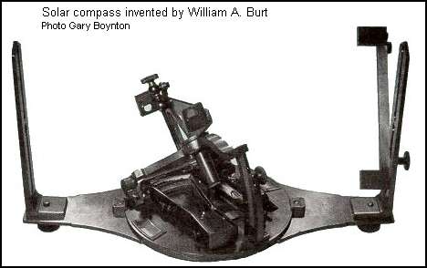
Burt continued to improve on his solar compass. The illustration above shows his "Improved Solar." The important parts of the instrument consist of a tripod to support the instrument, the plate body of the instrument with leveling screws and an arm that can be adjusted to the "latitude" (the position in degrees for the local location measured between the equator and the poles). Since the altitude of the sun varies from a high in summer to a low in winter, this position each day is known as the "declination," and can be found from tables; so, there is a setting for the declination of that day. There is an hour circle and a device to note the sun's image on a "tic-tac-toe" plate. The plate, or movable portion of the compass, can be clamped at 0�, or the meridian, and the whole instrument rotated until the image of the sun falls upon the plate when the indicator has been placed on the hour circle at the "local apparent time." When the image of the sun falls within the grid of the tic-tac-toe, the surveyor clamps the instrument and the sight arms now point north and south.
To arrive at "local apparent time," some effort is required. First, one must consider that the earth's globe is divided into 360 degrees of "longitude." The earth's rotation is 24 hours; so each 15 degrees of longitude is one hour, one degree is four minutes of time and one minute of longitude is four seconds of time. Time is measured from 0 degrees longitude (Greenwich, England). In the United States, for example, Eastern Standard Time is related to the 75� longitude and Central Standard Time to the 90� longitude. Care must be taken to consider Daylight Saving Time. [Adapted from an article by B. H. Boyum]