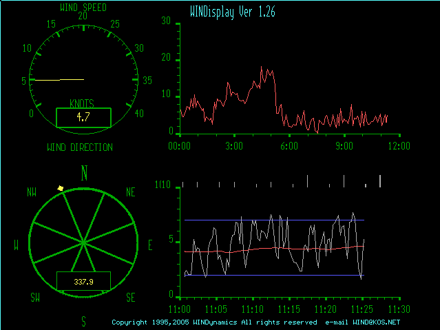
Note, in bottom right graph:
Blue lines represent the range in wind speed 90% of the time over the last half hour.
Red line is the average wind speed over the last half hour.
The Grey line is the instantaneous wind speed.
Note, in bottom right graph:
Blue lines represent the range in wind speed 90% of the time over the last half hour.
Red line is the average wind speed over the last half hour.
The Grey line is the instantaneous wind speed.
|
|
Buoy Data (water temp, wind speeds etc.) |
|
Wind Forecast by the WIND Guru
![]()
JETSTREAM DATA
Jet Stream Forecast (at the (x) hours in the future):
| TIME | Initial | 12hr | 24hr | 36hr | 48hr |
Wind Contour Plot for North America
This graph shows wind speed in a 'topograhical' type format.

Current Radar around Lake Ontario
Ottawa/Kingston RADAR (Environment Canada)
Western Lake Ontario RADAR (updated every 6 to 10 minutes)
Eastern Lake Ontario RADAR (updated every 6 to 10 minutes)
FAQ and Info on how to read the radar
Check the date on these plots. Sometimes the servers are down.
SYMBOLS for maps below

more symbols
if you want to read the rest of the graphs.
The length of the vectors in this image represent wind speed, their direction
indicate wind direction

For Long Term Weather look for iso bars close together on this graph
NOTE:
Image is now "clickable" for zoomed images. See links below for forecasts.

Click for
Satellite &
Surface (radar, anemometers etc.) all in one image!
Unisys Models - tricky to read but very good!
48 hour Forecast (NGM) for High's Lows and Isobars:
| TIME | Initial | 6hr | 12hr | 18hr | 24hr | 30hr | 36hr | 42hr | 48hr | 4panel | Loop |
10 day Forecast (MRF = Medium Range Forecast) for High's Lows and Isobars:
| TIME | Init | 12h | 24h | 36h | 48h | 60h | 3d | 3.5d | 4d | 4.5d | 5d | 5.5d | 6d | 6.5d | 7d | 7.5d | 8d | 8.5d | 9d | 9.5d | 10d | 9panel | Loop |
Surface Wind Speed Forecast (MOS):
| TIME | 12 hr | 24 hr | 36 hr | 48 hr | 60 hr |
Copyright © 2006
Kingston Boardsailing Association
updated: May18 2006