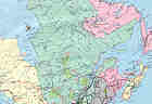
New Brunswick, Canada

Main Page

Back to Gallery


Eastern Canada
 

New Brunswick is Canada's western-most Atlantic  Province. Bounded by balmy ocean waters to the northeast and frigid sea water to the southeast, it offers a wide diversity of seaside personalities.

New Brunswick


The Bay of Fundy funnels the tidal waters into the gap between New Brunswick and Nova Scotia. It is this funneling effect which drives the dramatic tides in the area.
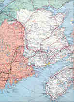
The West Isles


The West Isles of the Bay of Fundy block the flow of the tide waters from entering and exiting Passamaquoddy Bay. This results in very few exits for the water in the bay when the tide is ebbing in vice versa when it is flooding. Very strong currents are created by the channeling of such huge volumes of water through such narrow gaps.


To get there from the States, take I95 to Bangor, ME, then follow the sinuous, scenic # 9 to Calais,ME. Cross into Canada at St. Stephen, then follow NB # 1 to St.George. Follow the sign to the Deer Island Ferry down narrow route 766. You can put in here, around the corner at Greens Point Lighthouse or take the ferry over to Deer Island (best) and put in at the countless possible places on the island.

To get there from Canadian points west of New Brunswick, follow Route 20 through Quebec to Riviere du Loup. Follow #2, the Trans Canada Highway south through Edmunston to Prince William. Take the St. Stephen exit south on #3 then at St Stephen follow #1 east to St George. Follow the above directions to the Deer Island Ferry.

To get to Limekiln Bay, follow route 766 to Boarding House Road. a busy government dock is at the end. You could also continue further out 766 to Back Bay and put in at the Government dock there.

Hosted by www.Geocities.ws

1