|
|

|
|
Hello welcome to my "Fraser Island Information Page", this page was constructed to provide additional information about the World Heritage listed largest Sand Island in the World, Fraser Island. When you have finished checking out the details of "Fraser island", please check out the "links" to my other Hervey Bay web sites, which are linked below. I am proud to be associated with the many Web Services Listed on the various Sites that have been chosen by me. If time permits, check out the many FREE Web Services offered by me through my Internet Associates World Wide, "Click" on any of the "Links" at the bottom of this page. I am the ONLY FREE online independent Hervey Bay Booking & Marketing Service for Fraser Island and Hervey Bay Tourism Operators! |
|||
| Special Web Graphics by: |  |
 |
 |
|
 |
||||
| I have arranged lots of FREE Web Services, please fell free to make good use of them! | ||||
|
I was born at Howard (near Hervey Bay in 1938) and now reside permanently at Unit 2, Pauline Place, 16 Campbell Street, Torquay (right in the heart) of the Backpacker Resort area of Hervey Bay, Queensland, Australia. I have a small Email facility where Backpackers and International Tourists can come to do their email, and use my "Hear Me" Web based Telephone Service world wide FREE OF CHARGE! Over the years I have assisted many Backpackers, International Tourists and Visitors to Wide Bay district, and those especially wishing to visit the
I have received many requests from visitors to Fraser Island, to build web sites with pictures of Fraser Island, the World's Largest Sand Island, with Rain Forests, Beautiful Beaches, Pristine Clear Fresh Water Creeks, Springs and excellent Clear Lakes for swimming etc. Fraser Island is such a natural pristine place to visit, you will need at least 3 days to see it at it's best. We proudly boast that some 300,000 tourists visit the World Famous Fraser Island annually. The only way I can show you the beauty of Fraser Island, is to ask you to view the Pictures I have up-loaded to the Fraser Island site. "Banners" from the various companies that have assisted me to put these sites together, and provided pictures have been included on the Fraser Island Web Site, if you click on any "banner" of your choice it will take you to their web site in a new window! Check out the
Please feel free to download any of the pictures that you like, and please
sign my Guest Book, letting me know that you have visited the
sites and send an e-mail, with any comments or suggestions for changes to
the sites.
|
|||||
|
|
|||||
|
|
|
|
|||
|
The Fraser Coast is one of
Queensland's most attractive holiday destinations and is only a 3� hour drive north of Brisbane or a one hour flight
It has a remarkable diversity of experiences to offer, from World Heritage Listed Fraser Island itself; to the sheltered waters of Hervey Bay visited each winter by the
Humpback Whales; and the living history of Maryborough or the majestic Bunya Mountains. The unique environment which is Fraser Island is impressive in its sheer size and beauty. Its colourful history and Aboriginal heritage have made it a popular place for visitors to explore. For the naturalist, it is a rare and special garden. To the Aboriginal tribe which lived there for generations, it was paradise. To the angler, it means a full creel. To the 4WD enthusiasts, it is the ultimate off-road experience. To everyone who visits Fraser - it is the largest sand island in the world and one of Australia's World Heritage sites. |
|||||
| FRASER ISLAND INTRODUCTION | |||||
|
Fraser is the largest sand island in the world being 124km. long and covering an area of 163,000 hectares. It encompasses an amazing variety of landscapes, long surf beaches, cliffs and gorges in shades of orange, red, yellow and pure white sand, dense rainforests, vast, desert-like sand blows, freshwater lakes perched high up in the dunes, winding streams, great basalt headlands and salt pans with eerie mangrove forests. Scientists believe Fraser Island has developed over a period of approximately 800,000 years. Its sand comes from the tablelands of Northern New South Wales, washed into the sea by the big rivers of that area, and strong sea currents carry it north. Sand is the island's foundation, but water is its life force, giving rise to the island's vast tracts of forest. Fraser Island has an abundance of freshwater in its many lakes and crystal clear creeks and streams. Pristine clear mirror lakes and the peat-coloured perched lakes, are some of the largest of their kind in the world. Across the broad stretches of the ocean beach and running through the cool shady havens of the rainforests, comes the flow of the island's many creeks and streams. Water has meant the creation of exceptional rainforests, growing in sand and surviving on nutrients from the breakdown of other plants. Towering satinay and brush box are among the forest giants, some over a thousand years old. The variety of vegetation on Fraser is exceptional, ranging from mangroves to kauri forests and wallum heath lands that fill with wildflowers in the early Spring. The beaches and forests are the habitat of more than 230 species of birds - one of the largest and most varied bird communities in Australia. Isolation from the mainland has also ensured the purity of the island's dingo population. Now listed as a World Heritage site, Fraser joins the ranks of the Great Barrier Reef, Uluru and Kakadu National Parks as being of universal significance as the largest coastal dune system and sand island in the world and for its special environments. As a precious part of Queensland's natural and cultural heritage, it is protected for all to appreciate, enjoy and respect. |
|||||
| FRASER ISLAND NATIONAL PARKS, FOREST AND SAND | |||||
|
Fraser Island is part of the Great Sandy Region, the section of coastline stretching from the north shore of the Noosa River below lake Cooroibah and Cooloola National Park, to Sandy Cape at the northern tip of Fraser. About half of Fraser Island is currently national park. The Great Sandy National Park occupies the northern half of the island. The southern half is almost entirely crown land and state forests, proposed for national park, subject to resolution of Aboriginal land interests. Fraser has various centres providing information about the island and Great Sandy National Park. Information Centres can be found at Eurong National Parks and Wildlife Office, Central Station, Dundubara and Waddy Point. |
|||||
| FORESTS | |||||
|
Fraser's forests are one of the island's most remarkable and controversial features. Though the island was heavily logged, large stands of
satinay and brush box still remain. Pile Valley, between Central Station and Lake McKenzie, where much of the logging took place, has the tallest of the towering satinay and brush box. Satinay and brush box form part of the island's sub-tropical rainforests together with piccabeen palms and kauri pines. Fraser's rainforest are home to rare and ancient species including the angiopteris fern, which has the largest fern fronds in the world. The angiopteris fern is notable due to its use of water pressure rather than structural tissue to keep its fronds erect. The walkways along Wanggoolba Creek and Central Station, inland from Eurong, pass several of the magnificent ferns. Further north and inland from Happy Valley, the Yidney Scrub is home to a forest of 200-year old kauri pines. Fraser's vegetation is not all tall forest. Wallum heath lands occupy much of the lowlands. They consist of shrublands, scribbly gum trees and wallum Banksia. The heath lands spring to colour during August and September with a profusion of wildflowers. The western coastline of the island is fringed with mangroves backed by areas of cypress pine. |
|||||
| SAND FORMATIONS | |||||
|
The dune systems of the Great Sandy Region, which include Fraser Island, are the largest and oldest in the world dating back more than 30,000 years. Fraser is the world's largest sand island. Along the ocean coastline, the dunes take on at times sculptured shapes, giving rise to the names "The Cathedrals" and "The Pinnacles". There are 72 different coloured sands that occur on the island. The best coloured sands can be seen along a 35km stretch of the ocean beach north of Happy Valley. Sand blows are the other major sand formation, caused through the gradual action of shifting sand across the island. The Knife blade, just north of the wreck of the "Maheno", is the largest of the island's sand blows. A lookout provides an excellent lookout onto the beaches and dunes. Further north, Middle Rocks' Champagne Pools are deep natural rock pools, ideal for swimming Waddy Point is a popular base for anglers and provides good views from atop the lookout. |
|||||
| FRASER ISLAND WORLD HERITAGE LISTING | |||||
|
Fraser Island attained its World Heritage Listing in December 1992 in recognition of the island's exceptional sand dune systems, its rainforests on sand and its pristine freshwater lakes. Fraser Island is the tenth World Heritage listed site in Australia. The listing recognises Fraser's combination of environments as having outstanding universal value and its protection for future generations as a global responsibility. World Heritage Listings began almost twenty years ago under the auspices of the United Nations with establishment of the World Heritage Convention to which Australia is a signatory. 127 countries are party to the convention, established to identify, protect and preserve properties which qualify for World Heritage Listing. The two criteria against which Fraser Island was judged eligible for listing as a natural site were as follows: if it was an outstanding example representing significant on-going geological processes, biological evolution and man's interaction with the natural environment; and if it has superlative natural phenomena, formations or features. While the World Heritage Committee does not have the power to dictate how the listed site is managed, signatories to the convention, such as Australia, have an obligation to observe the ethic of the listing. The purpose of the World Heritage Listing is to recognise Fraser Island as having unique and precious natural environments of universal value that should be protected. Fraser Island has merged from a century of exploitation of its rich sources - timber, sand minerals and fish. Logging and sand mining have ceased after many years of campaigning by environmental groups. The challenge for the island in the future will be in managing the growth in tourism. A detailed management plan has been developed by the Fraser Implementation Unit, part of the Queensland Department of Environment and Heritage, for Fraser Island and Great Sandy Region which sets a strategy to the year 2010. The responsibility of protecting Fraser for future generations, however, belongs to all visitors in respecting the island's environments. |
|||||
| FRASER ISLAND WALKING | |||||
|
Leaving behind the 4WD and taking to the walking tracks is one of the best ways of appreciating Fraser Island's natural
splendour. Without the rumble of engines, the bird life can be seen and heard and the beauty of Fraser's wildflowers, its forests, lakes, creeks and sand formations seem all the richer. Walking tracks vary from a mere few hundred meters along some of the creek walkways, up to 13km. treks, such as that between Lake McKenzie and Lake Wabby. Before setting out ensure you have good, comfortable walking shoes, a broad-brimmed hat, sunscreen lotion, water, a good map and a compass is also advisable. Terrain on Fraser is generally easy, but walking on sand can be tiring and slow when the sand is soft. Avoid walking in the hottest part of the day and allow plenty of time to reach your destination before dark. Walking tracks in the southern half of the island: Dilli Village to Lake Boomanjin 7km. Lake Boomanjin Circuit 4km. Lake Boomanjin to Lake Birrabeen 10km. Lake Birrabeen to Central Station 5km. Central Station to Pile Valley 2km. Central Station to Lake McKenzie 6km. Lake McKenzie to Lake Wabby 13km. Lake Wabby to Ocean beach 3km. Walking tracks in the northern half: Ocean Lake Circuit 5km. Dundubara Creek to Wungul 3km. Dundubara to Lake Bowarrady 12km. The series of walks, particularly in the south of the island, can be combined for a trekking holiday over a few days. It's advisable to go in a group, preferably with experienced bush walkers and always advise park rangers of your itinerary before setting out. Maps and a compass are essential. Constructed walking tracks and old forestry roads make the easiest walking. Taking to the bush, off the beaten tracks is inadvisable and can be dangerous, particularly for the inexperienced bush walker, as swamps and thick heath land vegetation make many parts of the island difficult to traverse. The southern part of the island is well provided with water sources, but the northern half is dry in parts and freshwater is harder to locate. Consequently, hikers should always carry ample water supplies and food. Fraser is not snake free and care should be taken. However, mosquitoes and midges are the greatest wildlife threat, so it is advisable to apply insect repellent in the hotter months and after rain.
|
|||||
| FRASER ISLAND WILDLIFE | |||||
|
Fraser boasts around 230 species of birds, that flock to its beaches, rainforests,
heath lands, wildflowers and to its many lakes. Along the beaches, you can see dotterels, pied oyster - catchers, pelicans, terns and gulls while overhead the skies are prowled by
magnificent birds of prey - brahminy kites, white- breasted sea eagles, ospreys and peregrine falcons. The island's
heath lands are home to one of Australia's rarest birds - the ground parrot, as well as honey- eaters, kingfishers and cockatoos. The lakes and wetlands are the habitat of curlews, jabirus and brolgas. The separation from the mainland and the lack of grazing fields has meant that Fraser's land and water animals do not compare in numbers or variety to the island's exceptional diversity in vegetation. Nevertheless, Fraser's wildlife is exceptional in its own way. There are 25 species of mammal present on the island. Isolation has ensured that Fraser's dingoes are the purest breed in Eastern Australia and consequently no domestic dogs are permitted on the island. Visitors are advised not to encourage or feed the dingoes. Wallabies, possums, flying foxes and echidnas are some of the other native mammals, but there are no kangaroos. Dugong feed on the sea grass beds, turtles breed on some island beaches as well as the mainland and each year tailor make their annual migration to Fraser's rocky headlands to spawn. The annual migration of humpback whales from Antarctica to the warm waters of Queensland bring many of the magnificent whales into the sheltered waters of Platypus Bay, on the western side of Fraser Island. After calving in the waters further north, many of the whales retreat to Platypus Bay with their new offspring before returning to the rich feeding grounds of the Antarctic. During the weeks from August to October, licensed tour boats operate from Hervey Bay's Urangan Boat Harbour for visitors to watch the antics of the whales. Whale watching now attracts over 45,000 people per annum to what is a special part of the region's natural wonders. |
|||||
| TIPS FOR CAMPERS | |||||
|
Do not camp within 100 meters of a lake or 50 meters of a creek. Avoid digging trenches around your tent. Use fuel stoves in preference to wood fires. If using BBQ's, use wood provided. Do not feed or encourage the dingoes, goannas or other wildlife. Do not bury rubbish. Dispose of it in the proper bins or remove it from the island when you leave. Do not use detergents, soaps, toothpaste or shampoos in the lakes or waterways, it encourages damaging algal growth. Observe hygiene standards when camping without toilet facilities and bury human waste. Respect the peace of other campers. Do not create noise or play loud music. Boil water taken from natural sources. Leave the campsite tidy for other campers. |
|||||
| FACILITIES ON FRASER | |||||
|
Fraser Island has no towns but the resorts at
Eurong Beach and Happy Valley, both on the surf beach and
Kingfisher Bay Resort and Village on the western beach provide facilities for touring visitors. General stores, fuel and ice are available at some other locations. FUEL: Eurong Beach Resort, Happy Valley Resort, Kingfisher Bay Resort and Village and Cathedral Beach Camping Park.
|
|||||
| LIST OF QUEENSLAND NATIONAL PARKS |
|
||||
|
ABOUT QUEENSLAND Queensland is Australia's Sunshine and Holiday State |
|
||||
| MAPS: "Click" on the "Links" button |
|
||||
|
|
|||||
|
Please click on the Fraser Island logo above to go to the site! |
|||||
|
I now have an Online Web Photo Album, if you would like to view it, "click" on the "My Photo Album" button below, this album includes pictures of many interesting local district subjects! |
|||||
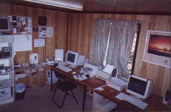 |
Left: This is a picture of my Email and work room. Click on "images" to view all of the full size thumbnails! |
||||
|
|||||
| PLEASE NOTE: Most of the images on this site have "mouse over" text for your convenience! | |||||
|
Click to subscribe to Fraser Island Group
|
|||||
| This web site was constructed by George Burnett | |||||
 |
|||||
� George Burnett 5th November 2000 |
|||||