Home | Personal | Academics | Fieldwork

7-1-96 First day of work at the site for us
volunteers. Poles
for shade and grid are already up. First we are given an
introduction/orientation to the site.
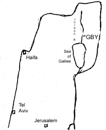 Location The GBY
Site is located on the east bank of the Jordan
River in
Upper Galilee, Israel, at the base of the Golan Heights. It is
situated on a level terrace right next to the river and the nearest
settlement is Kibbutz Gadot to the west. The bridge (gesher) for
which the site is named crosses the river just north of the site.
Location The GBY
Site is located on the east bank of the Jordan
River in
Upper Galilee, Israel, at the base of the Golan Heights. It is
situated on a level terrace right next to the river and the nearest
settlement is Kibbutz Gadot to the west. The bridge (gesher) for
which the site is named crosses the river just north of the site.
History The site was first excavated in the 1930's by Stekelis and
Garrod
(seperately) at locations nearer to the bridge and on the west bank of
the river. They found numerous handaxes and cleavers from the
Acheulian Era along with elephant, deer, and other mammal bones.
Excavations continued on and off until the 1950's. Gilead conducted a
small excavation in 67-68. In 1988, Naama Goren-Inbar, who runs the
present excavation, was made aware of the fact that outcrops of the
formation in which the site was located occurred much further south
than was previously thought. A geological survey was done to assess
the extent of the GBY formation and to pick a promising spot for
excavation. The first field season was in 1989 and work has continued
since then every summer except for the years 91-94 during which the
site was flooded by the Jordan River
Geology The GBY site is located in the northern most extension of
the
Great African Rift System, in the southern end of the Hula Basin. The
GBY formation consists of a series of fluvial/limnic deposits that are
clays with coarser clastics interbedded. The formation has been
tilted by tectonic activity, varying from 20° to 45°
depending on the location. It contains at least two distinct
archaeological horizons that are also marked by heavy concentrations
of the gastropod Viviparus apameae. The artifacts are concentrated
at the bases of these mollusc-rich layers. The entire formation is
approximately 25 meters thick and overlays unconformably a basalt
formation dated by K-Ar to between 800,000 and 880,000 years BP and is
overlain unconformably by recent floodplain deposits of the Jordan.
Paleomagnatism is normal throughout the sequence. ESR dates on tooth
enamel have come out between 500,000 and 600,000 years BP.
Artifacts Lithics- The majority of the worked pieces are bifaces
made from
basalt, which is the dominant material across the site as a whole.
flint and limestone are much less abundant. Tool types are the usual
ones found in the Acheulian. Features that give the assemblage an
African cast include; preference for basalt as a raw material, high
proportions of cleavers to handaxes, and the use of the Kombewa
Technique to produce bifaces. Most bifaces are not retouched
extensively, and show no signs of standardization. There seems to be
no correlation between material and tool type. The site itself is
waterlogged, which has caused an in-situ weathering of the basalt,
making it friable when it dries out and requiring special procedures
in order to stabilize it. When excavated, the pieces are placed in
plastic bags with water to keep them moist, and then are impregnanted
with a fixative in the lab.
Faunal- Animal bones from the site are well-preserved and include
types such as elephant, deer, bovids, rodents, and turtles. One
complete elephant skull that showed signs of butchering was found.
Other Organic- The water-logging of the site has caused excellent
preservation of organic materials such as seeds and wood. Several
fairly large pieces of wood have been found associated with the
archaeological horizons, including one plank that shows polishing.
7-3-96
Our days start early so as to avoid the hottest part of the day. We
try to be at the site by 5:00 AM- first light. The excavation areas
are shaded to help us stay cooler. We break for breakfast at about
9:00 and have a mid-day break between 11 & 12. At 1:00 we go back to
the kibbutz for lunch. Later on we'll use the afternoons for
lab work, but right now it's free time. There are 11 of us on the crew at
the moment, with 3 more coming on the seventh (I don't know everyone's
last names yet).
| Israeli | American | British |
| Na'ama Goren-Inbar | Graciela Cabana | Nicola Rousseau |
| Idit Saragusti | Kendra L. Malm | |
| Gonen Sharon | Jessica Murer | |
| Yoel Melamed | Emily Williams | |
| Nira Alperson | ||
| Eli |
7-4-96 Yesterday we began excavating. Procedures are as follows;
7-5-96 Today I finished 234/123a and 234/122d. Will complete this level when 234/122b is done. Uncovered more basalt flakes and cobbles, plus one limestone cobble and three retouched flint flakes. We need to keep the basalt damp, so it is sprayed with water and covered with cloth.
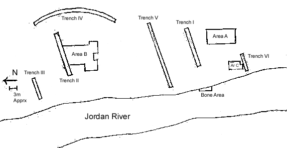
7-6-96 Finished 234/122b; uncovered two small bifaces just below central rock. To draw the plan map of the living floor, a grid was placed over the area at a precise location and angle, then Nira drew in the location and shape of each artifact on the master map. Each one was then given a number for identification and on Monday we'll "peel" the surface, recording location, elevation and angle. Even in this small of an area, the artifacts tend to cluster, but if this is due to pre- or post- depositional forces I can't tell. The matrix is cemented sand with large amounts of shell, which I would attribute to a lakeshore depositional environment. Emily, who is working on the remains of the other baulk (Graciela Baulk), found a flint handaxe, the first of the season and one of the few found so far at this site. Judging by the numbers of bifaces we've uncovered so far, the ratio of basalt to flint is about 6 to 1.
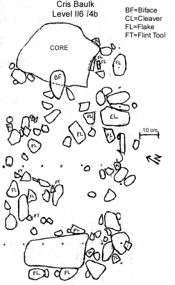
7-8-96 Nira is still working on the plan map, so we'll peel the surface tomorrow or the next day. To the right is a sketch copy of the plan map, which I'll add to as it's finished. I don't have time during the day to do one myself, just to copy it in the lab in the evenings. I've been shifted over to the center of the excavation area for awhile in an area that's down one level (II6l5). The artifacts are sparser and the matrix is a bit sandier. Overall, the density of the artifacts increases as one moves to the right (SSE), though this is not dramatic. The large rock at the top of the area is actually a core; it has four large flake scars concentrated on the downslope side, which couldn't be seen until it had been cleaned off. the basalt bifaces are practically all made on large flakes. This does seem more efficient; there would be much less retouch and thinning needed to create the tool. The one flint biface we've found shows much more extensive retouch. Three more crew members started work this week; Mikal, Mikal and Yulia.
7-9-96 Continued to work on the central area for awhile, uncovered some more cobbles and large flakes near the bottom (downslope) edge. Also found my first bits of wood and bone longer than 2cm. The bone has been fossilized, and it's a shaft fragment from a small animal. The wood is fairly soft and needs to be kept damp. After breakfast we began to "peel" the surface of the baulk area. Yoel is writing information on the bags and the map while I am taking coordinates and elevations, as well as angles for the flakes and tools. We have a stick contraption that hangs from the grid lines to make taking coordinates easier. It takes a little practice to use, but it's easier to use than rulers and more consistent. Both upper and lower elevations are for each artifact are taken, that is, before and after it's removed. The two small bifaces turned out to be pointed flakes with no retouch; sometimes it's hard to tell what an object is until it's removed from the ground. The whole procedure takes a fair amount of time, even with two people doing it. Taphonomically, these layers show little signs of disturbance; we're finding quite small flint flakes and bits of bone. The flints' edges have been worn somewhat smooth, which I would think would be consistent with a lakeshore environment of deposition. Other layers are mostly clay whereas the artifact-bearing layers are mostly sand. I've also been helping wash stuff in the lab during the afternoons; flint, bone and basalt pebbles from the general bags. We do a preliminary sort here, both in the field and in the lab, and all the natural pebbles get measured before they're boxed up. The cool stuff will get taken to Jerusalem for more extensive work at the end of the season.
7-10-96 We finished the peel of the baulk area, removing 94 numbered artifacts in all from an area 70cm X 130cm. Of that total we had 1 handaxe, 1 cleaver, 3 retouched flint flakes, and 17 large baslt flakes. The rest were basalt & flint pebbles and cobbles of probable natural origin. We're leaving the large core in place for now because its base is deeper than the present level. My next task will be to work some more on the downslope edge of the baulk because it wasn't excavated as far as the other areas & it leaves a small blank spot on the map. (Not really my fault; when the rest of the baulk had been previously removed a hump was left on the floor of the excavation & I only dug down to that level.)
7-11-96 Last night we had a demonstration by an Israeli flint knapper, Dodi Ben Ami. He made a range of tools from Lower to Upper Paeleolithic using hard hammer, soft hammer, punch techniques, & pressure flaking. He stated that Levallois was a concept where the idea was to remove a specific shaped flake and was done using several techniques, including indirect percussion. I'm not really convinced on this point, but he is a skillful knapper. He also said that he doesn't think much of the typologists who don't know anything about technology, on which point I do agree with him.
I excavated the bottom edge of the baulk & uncovered about a dozen more pieces, mostly basalt, one of which appears to be a biface. They're having me draw the plan map this time because Nira has been working on the other baulk. It's important to have the grid aligned properly and to keep the perspective perpendicular to the surface of the living floor to keep the plan map accurate.
7-12-96 We peeled the lower area of the baulk & found 2 handaxes & 2 cleavers. The cleavers in particular were in very good shape, probably due to the fact that they had been more continually kept wet over the years by being lower than the water table
7-16-96 Spent the last two days excavating the next layer of the baulk area, II6l5, and the finds have been fairly sparse. Most of them appear to be pebbles and cobbles, with just a couple of basalt flakes. One thing that I've just thought of is that we haven't found anything that is clearly a hammer-stone, though we've certainly found lots of rounded basalt cobbles. I'll have to look more carefully at what we're pulling up to see if I can see any signs of battering. I also haven't noticed any choppers or chopping tools. An interseting dichotomy if this is true; bifaces vs choppers. As I seem to recall, people usually only talk of a site as having one or the other & calling them Olduwan & Achuelian. Do most Achuelian sites contain choppers as well as bifaces, but get overshadowed by the more glamourous handaxes and cleavers?
Craig Feibel, our geologist, joined us this week. He's from Rutgers University.
7-17-96 I drew the plan map for Level II6l5 for my area today. The drawing tends to be a bottleneck because it takes time to do it accurately. Naama and Idit seem pleased to have another person with drafting skills to help out and keep the job moving along. I also numbered the artifacts on the map, using the next avalable from the bank.
7-18-96 Peeled Chris Baulk, Level II6l5; pebbles, cobbles, flakes and 1 handaxe. Density much less than II6l4b.
7-19-96 Drew plan map for level II6l5 of the other baulk area where Emily's been working. You need to be careful to keep your perspective perpendicular to the surface so that the relationships between objects don't get distorted.
7-20-96 Continued excavating II6l5, 2 to 3cm layers, and am now at about the same depth as the people in the center are. They've been working larger areas than I up until now. So I've expanded my area ever further toward them. Practically zilch in this level now; approximately 12cm until we hit Level II6l6.
7-22-96 Still at II6l5, and have connected with Nicola on my right. Spent the afternoon sieving; we dump a half-bucket's worth of sediment into the sieve then swish it in the river. We use a 2mm mesh so that there's lots of stuff left; mostly gastropod shells but also a lot of pebbles and a fair number of flakes. Then we place the remains in newspaper-lined cardboard trays to dry. When dried they are placed in heavy plastic bags with two tags, one inside and one outside.
7-23-96 Still working on II6l5. The actual digging is pretty easy; the matrix is a pebbly sand which isn't heavily cemented. We keep on going down without finding much of anything. During the breakfast break some of us ended up chasing a frisbee down the Jordon River, and while we were wading in the bar area south of the excavation, I looked down & spotted a handaxe among the cobbles. Picking it up revealed it to be a beautifully made chert handaxe. I noted several landmarks so as to pin-point its exact location, then took it back to the excavation. The area in which I found it turned out to be an area that was surface collected in 1989 when the water level was unusually low and the "Bar" exposed. Parts of the Benot Ya'aqov formation are being erode in this area and both surface & in situ finds were present. The assemblage of the Bar differs from the rest of the site by containing higher proportions of of chert bifaces and lower proportions of cleavers. Not unexpectedly, it had also been winnowed; very few flakes were found (Goren-Inbar, et al 1992). I believe this area is higher in the sequence than the levels we've been working on, but I'll have to ask Naama to make sure. The differences between the assemblages could be due to cultural change but taphonomic processes linked to erosion could also be playing a part (if the basalt artifacts are less sturdy). Nicola also found a handaxe along with two chert cores while we were wading, after I found mine.
7-24-96 The entire area except for the right-hand baulk (which is a little deeper than the rest now) is at one level. There are two clusters of artifacts along the lower edge plus a scattering of isolated ones. Therefore, we are now drawing a plan map, the second one, for Level II6l5. Nira and I are working on the left and right sides of the area respectively. We are trying to be quick about it as three people are left without employment while we are doing this. There is a backlog of sieving for them to do, but we want to get as much excavated as possible before we close up next week. I enjoy doing this drafting, it makes me feel as if I have a unique contribution to make to the dig.
I have found a couple of hammerstones while washing artifacts last week, after asking Naama about them. It's often hard to tell with basalt if there is any battering on an artifact or not. Only if a piece has been used repeatedly so that a flattened battered area has been created can one be sure that it's a hammerstone. Naama called this area "muller", a term I hadn't heard used before. Interestingly, when I picked up the hammerstones, they felt like hammerstones, fitting into my hand nicely & providing a striking area right where the battering was.
We also took a few minutes today to shoot in the locations of the artifacts Nicola & I found in the Bar yesterday with the laser transit.
7-26-96 Yesterday we took the entire day to finish drawing the plan map. We had spent only 2 hours or so the day previous drawing. It still takes a lot of time to get it accurate. There is a very large concretion just to the right of Graciela Baulk, where the strike of the layers changes. This causes problems when drawing both because of the fact that the orientation changes (and how to represent that on paper) and because the damn thing's in the way when you try to place the drawing grid.
All images and text Copyright 1998, 1999, 2000, 2005, 2008 by Kendra L. Malm, All Rights Reserved.
Any comments? E-mail me!
[email protected]
Return to my Home Page