Raleigh West, North Carolina Quadrangle
John Taber
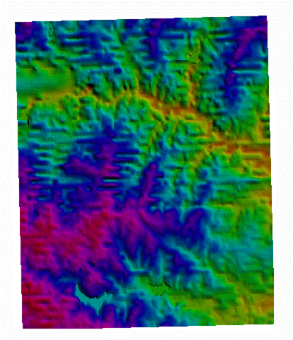
Figure 1: Digital Elevation Model
This image shows the elevation in the Raleigh
West, North Carolina
7.5-minute quadrangle (35.75 to 35.875 degrees
North, 78.625 to 78.75 degrees
West). It was derived from data downloaded
from the USGS Global Land
Information System (WebGLIS)
and processed in DLG Viewer version 3.7 using the
HSV shader. UTM
projection datum is NAD27 in zone 17.
Elevation ranges from 51 to
159 meters.
The red valley across the north is Crabtree
Valley, formed by Crabtree
Creek. The turqoise lake near the southwest
corner is Lake Johnson;
less apparent, a bit to the east (in green) is
Lake Raleigh. Lynn
Lake is in the northwest corner, and Shelley Lake
near the northeast corner.
The latter can be found by following major
tributary (Big Branch Creek)
from Crabtree Creek Now that this area has
been (largely) paved over,
the differences in elevation shown by this image
are not readily apparent
from the ground.
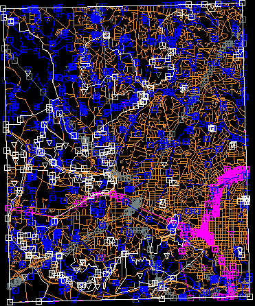
Figure 2: Digital Line Graph
This image shows five layers of vector data
derived from USGS topographic maps for the same
study area. It, too,
was processed in DLG Viewer from data downloaded
from WebGLIS. Boundaries are in white,
hydrology is blue,
pipelines are gray railroads
are pink, and roads are orange. Areas are
represented by triangles,
and nodes with squares. (These have been
removed from the roads layer
for clarity.) The less built-up area in the
northwest is part of
Umstead State Park, now surrounded by
development. Interstate 40
begins with the interchange on the western edge,
and arcs south across
to the southern part of the map. Interstate
440 begins at the southwest
corner, heading northeast across the center of the
map before turning east.
The railroad yards in the old industrial area of
Raleigh are near the eastern
edge.
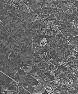
Figure 3: Digital Orthophoto Quadrangle
This image shows an orthophoto, or digitally
reconciled aerial view,
of the northwest part of the study area. It
was downloaded from WebGLIS
as a TIFF file and converted for this
project. (Cost was $7.50.)
This image was created in 1995, and unlike Figures
1 and 2, uses the 1983
projection of the North American Datum. The
interchange where Interstate
40 enters Figure 2 on the western edge is
prominently shown on the southwest
corner of this image. Umstead Park takes up
the western part of the
image. Lynn Lake can be seen at the
northwest corner.
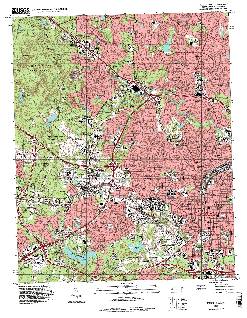
Figure 4: Digital Raster Graphic
This image shows the information found on the
USGS topographic map for the study area, in raster
form. This file was download from WebGLIS
for the cost of $1.00, and converted from TIFF
format. This image
was created in 1999, and also uses NAD83.
Urbanized areas are in
pink, forests in green. The four lakes noted
in Figure 1 can all
be easily seen here, as well as others.