| Map Reading |
Fig 3.2 illustrate a number of features as shown by contours and in elevation Contours are continuous. However far they run, they must in the end return to their starting points. The only exception is when a contour runs into a cliff where the slope is so vertical that there is no room in plane view to show the contours separately. In such a case, the cliff is usually shown by a symbol, and the contours run into it on either side where the slopes permit them to be shown. When the spacing of contours down a slope gets closer together at the bottom, the slope is convex. Convex slope means short visibility and field of fire: dead ground comes close. When the spacing if contours get further apart at the bottom the slope is concave. This gives long visibility. Irregular and closely spaced contours indicates rugged and broken slopes. Smooth contours indicate smooth slopes. Contours always run up rivers and streams. The sharper the angle at which the contours turns on the stream, the steeper the slopes on the sides. The correct interpretation of the shapes of the ground from the contours requires practices and experience on the ground. It is essential to study the various features, comparing the map and the ground in each case. First concentrate on the major features (ridges, valleys etc) and then study the minor features (variation of slopes, etc). With practice it should be possible to build up a mental picture of the shape of the ground from the study of the map only, and then to prove it by checking the ground. 4. Map References Grid Reference General Principle A grid is a rectangle system if lines superimposed on a map, within which any point can be defined and located by reference to the lines enclosing the squares within which the points falls. Each grid has a number at the edge of the map. The vertical lines numbering from west to east are known as �easting� and the horizontal lines numbering from the south to north are known as �northings�. |
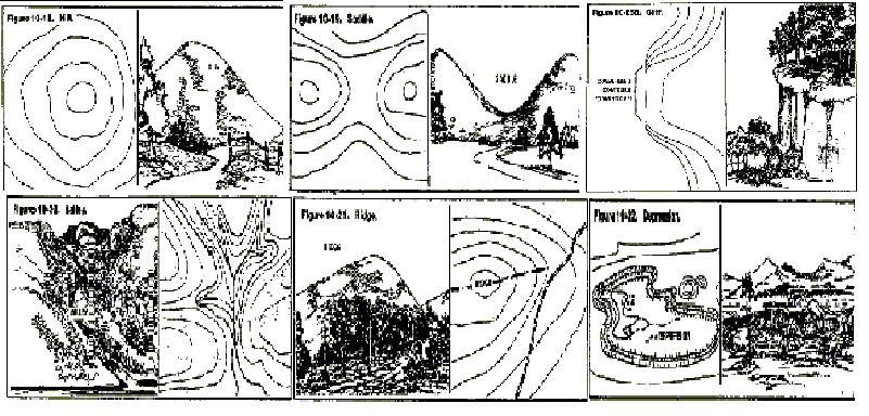 |
| Fig 3.2 Contour Shapes and Features |