The University
of Tulsa
Mountain Cedar Pollen Forecast
Metropolitan Area
|
Exposure Risk
|
|
Oklahoma City
|
Low
|
|
Tulsa
|
Low
|
|
St. Louis
MO
|
Low
|
Date Issued: 23
January 2009
Mountain Cedar Location(s): Arbuckle Mountains, OK
Regional Weather: Friday, January 23
– TX/OK: A cold front has entered the region this morning bringing
colder temperatures to Oklahoma today, but in Texas the warm
conditions will continue today. Skies will be partly to mostly cloudy in the
north to mostly sunny to the south. Temperatures across the region will
be variable as the cold front moves through Oklahoma
and into north Texas.
In central and southern Texas
it will remain unseasonably warm today but will then drop significantly
overnight and tomorrow. Winds will be moderate to strong today primarily
from the north, northeast in Oklahoma and the
south in Texas
switching late today and overnight to northerly winds as cold air moves in from
the north. In Oklahoma, high
temperatures will range from the 50s in the north to the low 60s in the south.
Winds will start light and variable but then become increasingly strong and
from the north during the day and into the evening. Tonight temperatures
will be in the lower 30s with partly cloudy skies then partly cloudy skies
tomorrow. Temperatures will only reach into the 40s on Saturday.
Winds will maintain moderate conditions and from the north to northeast.
Tomorrow night skies will remain partly cloudy with temperatures dropping into
the upper 20’s. In Texas, today’s
temperatures will warm into the 80s but with sunny to partly cloudy
conditions. Winds will be moderate from the south gaining in
strength this afternoon. Tonight temperatures will be in the lower 50s
across the region. Winds will remain strong (15-20
mph) across the region from the south but switch overnight
blowing from the north. Tomorrow skies will become partly cloudy across the
region. Significant cooling will result in high temperatures in the 50s
and low 60s tomorrow. Moderate to strong winds will continue from the
north eventually switching from a more easterly direction overnight.
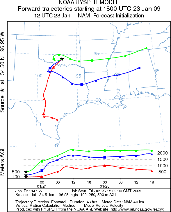
Trajectory weather: Air mass trajectories from the Arbuckle Mountains
are variable. At the lower altitudes the trajectories move to the south,
southwest along with the cold air moving into the region, but the upper
atmosphere trajectories first move west then circle back to the east. Partly
cloudy skies with temperatures in the low 60s will occur where the Juniperus
asheii population grows. Winds will be moderate to strong from the
north. Pollen entrained into the atmosphere will have its greatest impact
in communities southwest of the population. Tomorrow winds will relax a bit
then increase again with a slight shift to an easterly direction.
Conditions in the tree population in the Arbuckle
Mountains
will be good for pollen release today because of warm conditions and moderate winds.
Atmospheric conditions will result in moderate to good conditions for travel of
pollen entrained in the atmosphere.
OUTLOOK: *** High Threat *** mostly
favorable conditions for pollen release along with fairly good conditions for
entrainment and transport. Warm conditions with moderate to strong winds
will present favorable conditions for pollen release, and good conditions for
entrainment and travel. Winds today will be primarily from the north,
northeast. Atmospheric conditions across the region will result in good
conditions for the dissemination of pollen.
Trajectory Start (s) (shown by black star on map): Sulfur, OK.
Prepared by: Peter K. Van de Water (Department of Earth
andEnvironmental Science, California State
UniversityFresno), and Estelle Levetin (Faculty of
Biological Science, The University of Tulsa, 800
S. Tucker Dr., Tulsa, OK74104). This forecast gives the anticipated future
track of released MountainCedar pollen, weather conditions over the region and
along the forecastpathway, and an estimated time of arrival for various
metropolitan areas.
Questions: Aerobiology Lab e-mail: [email protected]
Return to ForecastingHome
Page