 The reality of standing at Gospel Pass and looking
out over England and Wales had started with a search of the internet. I
wanted to do a bicycle tour in Great Britian that included a rural setting,
camping opportunities, and few tourists. In addition to probing the internet
with search engines I sought advice and counsel from the listserv [email protected]
as well as the newsgroups rec.bicycles.rides and uk.rec.cycles. I joined
the Cyclist's Touring Club- Britain's largest cycling organization (www.ctc.org.uk)
whose bimonthly magazine is a wealth of information. What evolved over the
next ten months was a plan to tour along the border of England and Wales.
The reality of standing at Gospel Pass and looking
out over England and Wales had started with a search of the internet. I
wanted to do a bicycle tour in Great Britian that included a rural setting,
camping opportunities, and few tourists. In addition to probing the internet
with search engines I sought advice and counsel from the listserv [email protected]
as well as the newsgroups rec.bicycles.rides and uk.rec.cycles. I joined
the Cyclist's Touring Club- Britain's largest cycling organization (www.ctc.org.uk)
whose bimonthly magazine is a wealth of information. What evolved over the
next ten months was a plan to tour along the border of England and Wales.
The solo unsupported tour began at the end of a family vacation that included
a week in the Cotswolds and ten days in London. We used Delta's nonstop
service to Gatwick from Cincinnati. I took my Specialized Sequoia touring
bike and a duffel containing associated gear. A rack to transport the bike
to our rental cottage in Chipping Campden fit in a suitcase. Since we didn't
exceed the limit of two pieces of luggage per passenger the bike flew free
in a box provided by Delta at the airport. I took off the pedals, removed
the stem/handlebars and taped them to the top tube which was protected with
a length of foam pipe insulation.
The bike was sitting at the baggage claim area when we arrived. I removed
it from the box and wheeled it across the street to our waiting rental car.
The rack was assembled and fitted to the car. After arriving in Chipping
Campden I assembled the bike and took several rides before doing a day trip
by car to Hereford. I had made arrangements by phone to store my bike at
Coomb's Cyclery in Hereford while we were in London. We located the bike
shop and dropped the bike and gear off before returning to Chipping Campden
and then moving on to London.
Day 1 Thursday, July 1
We arrived at the airport about 9:00 AM. My wife and sons were schduled
to leave at 11:00 AM. The previous day I had purchased a ticket to Hereford
(with return) for 33 B.P. An additional 1 B.P. secured a reservation for
my bicycle on the return. I said goodbye to my family and made my way to
the Gatwick train station. The trains are comfortable, smooth, and swift.
I had to make changes at Reading and Newport. I arrived in Hereford in about
four hours. I walked to Coombs Cyclery to collect my bike and gear. I repacked
my panniers and changed into cycle clothing. I had a bicycle specific map
for Herefordshire (The "Hereford Hundred" map and guide available
from the Hereford Cycle Users Group for $10.00. E-mail: [email protected]).
A little after 4:00 PM I pushed off into traffic and reaquainted myself
with the slow heavy feeling of loaded touring. I headed northwest for Woebly
under overcast skys. I was soon on country lanes with no traffic. The terrain
was rolling with a couple of steep climbs. Self doubt was pervasive! The
bike was heavy. I was feeling weak. Was I up to the demands of touring in
this area or was it just the fatigue of a hectic day of travel? At some
point I settled into a rhythm and relaxed. I had ten days of solo touring
ahead of me. If I didn't have a good time I had no one to blame but myself.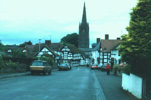 I rolled into the village of Weobly a little over an hour later. I
visited the church and took photos of the "Black and White" houses
the area is noted for. I went to the local store for a yogurt and a can
of Guinness. I was pleased to see that the large cans were only 85p. Some
of the old advertising pieces for Guinness include the line "Guinness
for Strength". Obviously I could use some of that. I continued on towards
Broxwood and before long a young orchard behind a tall hedgerow presented
itself. I decided to make camp there for the night as the overcast was getting
heavier and I wanted to set up and eat before it rained. It did drizzle
a couple of times but not enough for raingear. The entire area around the
orchard was populated with sheep and cows. As I settled in to read I realized
they seemed to have a lot to talk about. I was tired and didn't have to
resort to counting the nearby inhabitants before quickly falling asleep.
Mileage today- 18
I rolled into the village of Weobly a little over an hour later. I
visited the church and took photos of the "Black and White" houses
the area is noted for. I went to the local store for a yogurt and a can
of Guinness. I was pleased to see that the large cans were only 85p. Some
of the old advertising pieces for Guinness include the line "Guinness
for Strength". Obviously I could use some of that. I continued on towards
Broxwood and before long a young orchard behind a tall hedgerow presented
itself. I decided to make camp there for the night as the overcast was getting
heavier and I wanted to set up and eat before it rained. It did drizzle
a couple of times but not enough for raingear. The entire area around the
orchard was populated with sheep and cows. As I settled in to read I realized
they seemed to have a lot to talk about. I was tired and didn't have to
resort to counting the nearby inhabitants before quickly falling asleep.
Mileage today- 18
Day 2 Friday, July 2
I awoke to heavy overcast and 65 degrees. I was packed and on my way by
7:00 AM. I had chosen the route from Hereford because of its obvious "back
road" presentation on the map and I continued on the same type route
headed north towards Pembridge. It was a one lane hard surface road whose
occasional high hedgerow blocked the surrounding view. I passed many farms
obviously engaged in raising sheep and cattle. I passed Dunkerton Cider
Works, but they weren't scheduled to open for another 3 hours. I turned
northeast just beyond Pembridge onto route B 4362. There was some light
traffic with an occasional lorry (heavy truck). No shoulder to ride on but
the English have a way of demanding their share of the middle of the road
when it becomes necessary to pass cyclists and the oncoming traffic gives
it to them. They are very good at dealing with bicycles on the road, my
assumption being that they encounter them more often than drivers in the
US. When I had been operating an auto in the Cotswolds in June I noticed
that the cyclists I came across were courteous and predictable. Mutal respect
goes a long way in shaping a good relationship.
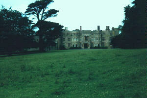 I turned off of the road to visit Croft Castle,
but it also was still closed. The terrain had been fairly flat this morning,
but that was changing. Near Orleton I turned north towards Ludlow. I decided
to follow the signs to Richard's Castle. Very little remains of the castle,
but it was one of just several pre-Norman castles in all of England. Ludlow
has a large castle that was producing its annual Shakespeare Festival. The
stage was set up in the inner courtyard and used the castle extensively
as part of the performance. It was market day and that plus the clearing
skies imparted a party atmosphere to the town. I celebrated by treating
myself to a 1/2 roast chicken lunch prior to visiting the castle. People
at the pub and the castle were conscious of my concerns regarding my bike
and panniers. Both establishments allowed me to push the bike into courtyard
areas that provided more security.
I turned off of the road to visit Croft Castle,
but it also was still closed. The terrain had been fairly flat this morning,
but that was changing. Near Orleton I turned north towards Ludlow. I decided
to follow the signs to Richard's Castle. Very little remains of the castle,
but it was one of just several pre-Norman castles in all of England. Ludlow
has a large castle that was producing its annual Shakespeare Festival. The
stage was set up in the inner courtyard and used the castle extensively
as part of the performance. It was market day and that plus the clearing
skies imparted a party atmosphere to the town. I celebrated by treating
myself to a 1/2 roast chicken lunch prior to visiting the castle. People
at the pub and the castle were conscious of my concerns regarding my bike
and panniers. Both establishments allowed me to push the bike into courtyard
areas that provided more security. 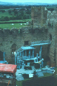 I found people
to be reserved but their reservations melted away quickly given the opportunity
to engage in conversation. Their first questions were usually an effort
to find out where I was from and where I was going. I always wear a helmet
and over time I found that for the most part only children wear helmets
in England and Wales. Even other bicycle tourists would ask me what that
device on my helmet was about. When I explained that it was a mirror, they
thought that was very "clever" indeed.
I found people
to be reserved but their reservations melted away quickly given the opportunity
to engage in conversation. Their first questions were usually an effort
to find out where I was from and where I was going. I always wear a helmet
and over time I found that for the most part only children wear helmets
in England and Wales. Even other bicycle tourists would ask me what that
device on my helmet was about. When I explained that it was a mirror, they
thought that was very "clever" indeed.
The climb out of Ludlow to Haze Coppice was 2 1/2 miles. I used most of
that 1/2 chicken lunch making that climb. It climbed through forest land
and I contiuned on into the forest on a side dirt road for a mile or so
before breaking out of the tree cover and getting a spectacular view of
the valley I would be entering once I made my way back to the main road.
I encountered three mountain bikers whose safety equipment made them look
like a cross between Darth Vader and the 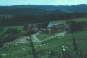 Power Rangers.
The descent into the valley was swift and soon I was in Elton. The map showed
a cycle faciltiy so I continued on to Wheely Wonderful Cycling. I met the
owner Chris Dartnell who runs the business of renting cycles by the hour
or by the day. (Wheely Wonderful Cycling; Petchfield Farm; Elton, Nr. Ludlow;
SY8 2HJ Phone 01 568 770755) Chris was kind enough to sit down with me and
look over my route layout and make suggestions for additions and changes.
I continued west on the route he suggested which resulted in low traffic
and good scenery all the way to Knighton. I purchased food there and noted
the opening hours for the bookstore where I planned to obtain a map that
included nearby Wales. I backtracked to a field with a million dollar view
and pitched the tent. The skys were clear as I prepared dinner. The surrounding
hills were inhabited by sheep. Around midnight a heavy thunderstorm came
through showing me I would have profited by waterproofing the tent's fly
before leaving home. Mileage today- 51.
Power Rangers.
The descent into the valley was swift and soon I was in Elton. The map showed
a cycle faciltiy so I continued on to Wheely Wonderful Cycling. I met the
owner Chris Dartnell who runs the business of renting cycles by the hour
or by the day. (Wheely Wonderful Cycling; Petchfield Farm; Elton, Nr. Ludlow;
SY8 2HJ Phone 01 568 770755) Chris was kind enough to sit down with me and
look over my route layout and make suggestions for additions and changes.
I continued west on the route he suggested which resulted in low traffic
and good scenery all the way to Knighton. I purchased food there and noted
the opening hours for the bookstore where I planned to obtain a map that
included nearby Wales. I backtracked to a field with a million dollar view
and pitched the tent. The skys were clear as I prepared dinner. The surrounding
hills were inhabited by sheep. Around midnight a heavy thunderstorm came
through showing me I would have profited by waterproofing the tent's fly
before leaving home. Mileage today- 51.
Day 3 Saturday, July 3
The morning sky was still threatening rain which caused me to linger in
the tent. In my opinion the worst rains are those that come when you are
trying to set up for the night or when you are trying to get packed up and
underway in the morning. I had found out yesterday that England has an abundant
supply of stinging nettles that grow along the hedgerows and fences. Occasionally
one will be in your line of travel and whip your leg as you go by. It only
takes about 20 seconds to find out if it was nettles or some benign weed.
This particular field had an oversupply of them. I finally convinced myself
that the sky was brightening so I packed up and returned to Knighton. 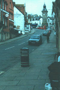 I went to the bookstore and purchased an Ordinance Survey Map that included
the area west and south of Knighton. (Landranger series #148, Presteigne
and Hay-on-Wye area). I talked maps with the shop owner and he pointed out
that in his opinion the Ordinance Survey Maps were probably the best maps
in the world. He was quick to add that the best comes at a corresponding
high price. He was probably correct on both points, most certainly on the
second as they are 5.25 B.P. (about $9.00) I planned a route that swung
west into Wales through Knucklas, Heyop and Dolyfelin before turning south
towards Llangunllo and Monaughty. I would then turn east towards Presteigne.
I went to the bookstore and purchased an Ordinance Survey Map that included
the area west and south of Knighton. (Landranger series #148, Presteigne
and Hay-on-Wye area). I talked maps with the shop owner and he pointed out
that in his opinion the Ordinance Survey Maps were probably the best maps
in the world. He was quick to add that the best comes at a corresponding
high price. He was probably correct on both points, most certainly on the
second as they are 5.25 B.P. (about $9.00) I planned a route that swung
west into Wales through Knucklas, Heyop and Dolyfelin before turning south
towards Llangunllo and Monaughty. I would then turn east towards Presteigne.
By avoiding the contour lines on the map I was able to stay off of some
the roads that would have had the steepest hills, but I still had some climbing
to do. The bike was just too heavy and my left knee was bothering me. I
stopped in a pub of the very small village of Llangunllo and purchased a
half pint of Guinness to chase the lunch of bread and cheese I had enjoyed
just around the corner at the memorial to the local men killed in the "Great
War". I enjoyed conversation with the only other patron concerning
the size of the US and the great travel distances we incurred as a routine.
He had moved to the area from England because of what he described as its
"roughness" which I soon realized meant because of its rural setting.
I continued on to the churchyard where a man was trimming the trees. He
told me he had been a farmer all of his life just a mile outside the community
but had "moved into town" (!) when he retired. A little further
down the road I stopped to check my map and a farmer asked me where I was
going. I told him I was headed for Presteigne to which he replied, "Well
then, you'd be lost!" I laughed and explained I wasn't necessarily
looking for the shortest route while his look told me that was good because
I wasn't on it. When I asked if he raised sheep and cattle he stared at
me as though I was a little short on intellect. "Raising stock is all
we can do around here", he said while indicating with his thumb and
forefinger a distance of about four inches, "We've only got this much
soil to work with. We raise a little bit of hay and get along the best we
can."
Even though I had what was generally a downhill run from Llangunllo to Presteigne
I had a brisk headwind that was aggravated by the panniers acting to catch
it. On the west side of Presteigne I came to Rockbridge Park, a campground/caravan
park run by Roy Deakins. I have been camping all of my life but Rockbridge
Park is the nicest facility I've ever encountered. Spotlessly clean hot
water showers, sinks, and toilets. Facilities for washing dishes as well
as a washer and dryer. There was also a refrigerator for the campers use.
Huge, open, nicely mowed (and swept!) areas for tents. No evidence of overuse
and in fact I shared the facilities with only one other tent on each of
the two nights I spent there. The River Lugg was at my back and a huge hillside
covered with fields of sheep lay before me. This beautiful little piece
of real estate was only 4.00 B.P. a night. After I set up my tent Roy came
by and told me that there was a local town council barbeque that evening
which I would be welcome to attend. For 5.00 B.P. I would get a meal and
afterwards there would be a local band playing. It was less than 2 miles
away and it sounded like fun. It was held on the lawn of a local businessman's
18th century home. The meal was good, but the five piece band was outstanding.
Guitar, bass and drums along with a fiddle/squeezebox man and a saxaphone
player. Local guys in the 35-50 age group that were outstanding muscians
(the fiddle player was a concert violinist). They called themselves the
Tango Band and played a great range of music. Mileage today 33.
Day 4 Sunday, July 4
I was awakened by the sound of frantic sheep. Opening the tent I saw that
a farmer seated on a tractor was working one particular pasture with five
sheepdogs. The dogs were gathering the several hundred sheep into a group.
Occasionally the farmer would admonish them by shouting "Dogs, Dogs..."
and apparently they would mend the error of their ways. Once the sheep were
grouped he drove through the open gate to the next section of pasture and
the dogs followed to repeat the process on the next several hundred sheep.
Meanwhile the previous group began to scatter and resume normal sheep behavior.
I can only assume it was a series of practice sessions, perhaps designed
to give some experience to a younger dog. I found it to be great Saturday
morning entertainment and the sheep seemed to accept it as their burden
to bear.
I decided to remain at Rockbridge Park for another night and do a day ride
from here. I was tired of carrying the household with me. It was 65 degrees
and overcast. There had been a line of light showers pass through during
the night. It had been cyrstal clear at 11:00 PM.
I headed south towards Kington. I rode through
Discoed (I could have dance all night?), Beggar's Bush, Evenjobb, Lower
Harpton, and Walton before a shower caused me to stop and begin to dig out
the raingear. As soon as I stopped the shower had passed and I continued
on to Kington where I had a sandwich and a "fizzy drink" (carbonated
soft drink). I was enjoying the ride even though it was overcast and the
scenery wasn't spectacular. It was great to be riding without the panniers
for a change. I turned northeast and took a quick detour to Staunton on
Arrow to visit a church I could see from my route. I stopped in Shobdon
to watch the traffic at the air park. The local soaring club was apparently
able to find some thermals in the clearing skies while helicopter and small
plane traffic kept the runways active. I soon realized that I was retracing
some of the 2nd day's route. I had failed to notice this immediately because
I was now working off of the Ordinance Survey map. I turned northwest just
before reaching Mortimer's Cross and passed through Upper Lye, Upper Kinsham,
and Lower Kinsham before returning to Presteigne. Mileage today 46.
I rode through
Discoed (I could have dance all night?), Beggar's Bush, Evenjobb, Lower
Harpton, and Walton before a shower caused me to stop and begin to dig out
the raingear. As soon as I stopped the shower had passed and I continued
on to Kington where I had a sandwich and a "fizzy drink" (carbonated
soft drink). I was enjoying the ride even though it was overcast and the
scenery wasn't spectacular. It was great to be riding without the panniers
for a change. I turned northeast and took a quick detour to Staunton on
Arrow to visit a church I could see from my route. I stopped in Shobdon
to watch the traffic at the air park. The local soaring club was apparently
able to find some thermals in the clearing skies while helicopter and small
plane traffic kept the runways active. I soon realized that I was retracing
some of the 2nd day's route. I had failed to notice this immediately because
I was now working off of the Ordinance Survey map. I turned northwest just
before reaching Mortimer's Cross and passed through Upper Lye, Upper Kinsham,
and Lower Kinsham before returning to Presteigne. Mileage today 46.
Day 5 Monday, July 5
It was a beautiful morning and after packing up I pedaled into Presteigne
to purchase something for breakfast. An elderly gentleman approached me
on the street and asked me about my bicycle. It turned out that he was a
bicyclist. He told me that he was 87 years old and traveled to South Carolina
each summer to ride with an 84 year old American friend. In turn during
the summer his friend would travel to Presteigne to spend time riding with
him. They had met 20 years ago on a bicycle trip and had been getting together
ever since. He glanced at his watch and said that he had to be getting along
as he was the bellringer at his church which was several miles away. He
told me that the congregation was very small now and everyone who attended
church there was over 80 years of age. He smiled as he explained that he
was the only one left who was capable of ringing the bell. When I asked
he told me that he had been ringing the bell for the past 51 years. He tucked
his trousers into his socks and pedaled off to his bellringing.
I stopped on the edge of town to check my map and another bicyclist stopped
to ask me if I needed help. I explained I was headed to Hay-on-Wye and showed
him the route I had planned. He proposed a more westerly route and when
I told him it looked like a lot of hills he suggested the whole map looked
like a lot of hills! I agreed that it did promise a more rural setting,
while he guarenteed outstanding scenery. His name was Andrew and he had
a shop in Hay-on-Wye where he sold antique rugs and textiles. He said the
shop wouldn't be open until Wednesday, but if I was still there I should
stop in.
I rode southwest along the B 4362 until I reached Walton and then started
climbing a short section of country lane towards Old Radnor. I stopped at
the church at the top of the hill. A lady was sweeping the walkway into
the church in preparation for a funeral that day. She told me there had
been a church there since the 14th century. At the bottom of the hill I
reached Dolyhir and continued on the B 4594. I continued the southwesterly
direction and started climbing again before descending into Gladestry. The
tiny store/post office was attached to a residence and couldn't provide
any cold drinks. The small assortment of drinks was sitting on an open shelf
along the wall. They did, however, have an assortment of ice creams snacks
and the mint chocolate drumstick was delicious. Another long climb up and
a swift descent into Newchurch. The bottom of the hill had a sign declaring
it to be a 14% grade, but it seemd much steeper as I was on the brakes a
lot.
Andrew had been correct in declaring the route to have outstanding scenery.
I began the climb out of Newchurch and as I reached the top I took a lane
that climbed higher still to Bryngwyn. I swear I saw a mailbox in this area
that listed the pick up time as "Tuesday". I came to another beautiful
old church (St. Michaels) beside a farm that advertised pony trekking. A
short distance further on and I was entering the Common. Areas along the
ridge line were common grazing areas that went for great distances without
fences. The Common itself was fenced along the edge and entrance was achieved
by driving over "stock guards" which were usually pieces of 6"
wide steel that were seperated by a 6" space. Animals avoided these.
I found them intimidating enough to cause me to walk my bike over them whenever
I encountered them on the lanes I traveled. I didn't spend much time on
the Common as the signage forbid any camping and asked that you stay on
the roadway. I'm sure it would have been a glorious ride.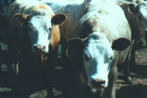 I didn't see
many signs restricting entrance to places during my tour and the few I did
see I honored. I found very few locked gates. Two signs that I remember
were "Bull in Field" and "Our Dogs BITE !"
I didn't see
many signs restricting entrance to places during my tour and the few I did
see I honored. I found very few locked gates. Two signs that I remember
were "Bull in Field" and "Our Dogs BITE !"
I rode down to the B 4594 and rode through Rhos-goch and on into Paincastle.
I left the B road and turned southeast out of Paincastle and started another
climb. On the way up a sign declared it to be "1:8". The other
side was a real screamer down towards Clyro. I was becoming accustomed to
the bike's handling with the added weight, but was still surpirsed when
I realized I had reached a speed of 40 mph on the descent.
I rode on B 4351 out of Clyro and just before dropping down the hill into
Hay-on-Wye I stopped and set up at a campgrounds (3.00 B.P.) overlooking
the valley with the town centerstage. There were several tents set up along
the hedge. I added my tent to the row and pedaled on into town. Hay-on-Wye
advertises itself as the book capital of England as it has a large number
of bookstores. It was probably the most tourist oriented town I had biked
through but it was still a very pleasant place and definitely was not crowded
or overused. It ended up being one of my favorite towns. I stopped to pick
up some food at one of the stores and generally looked the town over. Before
going back to the campsite I went to the Tourist Information Center on the
edge of town and purchased the ajoining Landranger map (#161).
While I was preparing my dinner a hiker walked in. Offa's Dyke Path skirted
the edge of Hay-on-Wye and several of the people in camp were walking the
path. It runs from Chepstow up to the Irish Sea. The new arrival was Cameron,
an Austrailian in his late 20's, who had taken a six month leave from his
job with a law firm. He had been walking in the rain most of the day. He
had walked 28 km. and the skin on his wet feet had gone soft and blistered.
He seemed to have brought the rain with him as thunder showers rolled in
and turned into an all night rain. Mileage today 28.
Day 6 Tuesday, July 6
I left the campsite about 8:00 AM. Cameron said he was taking a day to allow
his feet to recover and to explore Hay. I had decided to do a day ride in
the Golden Valley. This valley runs southeast from Hay-on-Wye following
River Dore. I rode in the valley as far as Dorstone on the B 4348 before
turning south towards Snodhill. The lane began to climb immediately and
the stretch between Snodhill and Snodhill Park was a real lung cleaner.
I managed to misread the map and turned up another lane and put in another
half mile of climbing before I realized I had pedaled up a hard surfaced
private lane to a farm. I couldn't figure out where I was on the map so
I knocked on the door of one of the houses on the property. An older woman
came to the door and when I told her I was lost she told me that occasionally
she had lost hikers come to her door. When I told her I wasn't a hiker but
in fact was a bicyclist she laughed in surprise and exclaimed, "Well,
I'd have to say you are the first lost bicycle rider to knock on my door!!"
The Landranger maps have many of the isolated farms identified by name.
When she told me the name of the farm I was immediately able to find it
and my position on the map. I thanked her and enjoyed the half mile run
down to the proper lane.
 Luckily the majority of the climbing was behind
me and I was able to savor the view from the ridge. It was a beautiful sunny
day with a nice breeze. Several farmers were working their hay fields, but
I encountered only two cars along this route. Occasional farm houses and
lots of sheep and cattle. On my left was the Golden Valley while to my right
was the Olchon Valley. Beyond the Olchon Valley were the Black Mountains.
I rode along this ridge for about 8 miles before turning and heading down
to Ewyas Harold and then turning northwest to follow the
Luckily the majority of the climbing was behind
me and I was able to savor the view from the ridge. It was a beautiful sunny
day with a nice breeze. Several farmers were working their hay fields, but
I encountered only two cars along this route. Occasional farm houses and
lots of sheep and cattle. On my left was the Golden Valley while to my right
was the Olchon Valley. Beyond the Olchon Valley were the Black Mountains.
I rode along this ridge for about 8 miles before turning and heading down
to Ewyas Harold and then turning northwest to follow the
B 4347 back up the Golden Valley towards Hay-on-Wye. The ride in
the valley was a hot one and there wasn't the breeze I had enjoyed on the
ridge. There was some traffic, but it wasn't bad. I visited about four churches
including Dore Abbey. An amazing building started in 1147. Services are
still held there.
The ride in
the valley was a hot one and there wasn't the breeze I had enjoyed on the
ridge. There was some traffic, but it wasn't bad. I visited about four churches
including Dore Abbey. An amazing building started in 1147. Services are
still held there.
Further up the valley at Dorstone I turned northeast to visit Arthur's Stone.
It was a climb of one mile and the first section was advertised as a 25%
incline. Arthur's Stone is a late Neo Lithic (3500-2500 BC) burial chamber.
It was a nice place to rest and enjoy the view across the valley. The route
down was fast and at the bottom it was signed as being 20%.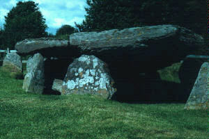
I rode back into Hay-on-Wye and visited some of the bookstores as well as
a number of other shops. I was safe from making any large purchases at the
bookstores as I couldn't imagine carrying more than my current reading book
in my panniers. Mileage today 42.
Day 7 Wednesday, July 7
The day started with an overcast sky and a temperature of 63 degrees.
I debated how I would spend the remaining time. I had four full days left.
The agent who had sold me my train ticket had explained that I had options
on the return. While it was a ticket to Hereford with a return I wasn't
commited to getting the train in Hereford. The first segment of my return
to Gatwick would be from Hereford to Newport on the Wales Western line.
I could board the train anywhere along that line. That meant I could catch
the train in Hereford, Abergavenny, Ponty Pool, Cwmbran, or just board the
train in Newport that went to Reading. I had already decided that I didn't
want to return to Hereford. While I didn't make a decision on how I would
use the four remaining days I did decide to spend another night in Hay-on-Wye.
A number of people had told me what a great view was available from Hay
Bluff. Hay-on-Wye has an elevation of about 85 m. (280 ft). Hay Bluff was
about 5 miles by road from Hay-on-Wye and was 677 m. (2220 ft) at the summit.
The road skirted Hay Bluff and then passed between it and Lord Hereford's
Knob (690 m.) at Gospel Pass before dropping down on the other side into
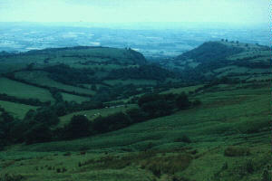
the Vale of Ewyas. I decided to try the climb to Gospel Pass. The pass was
542 m. (1778 ft). The map showed a section of the road to be between 1:7
and 1:5.
Cameron's feet had recovered enough that he packed up and was continuing
his walk to the Irish Sea. I left the campground and stopped in Hay-on-Wye
to purchase some food for the day. It was about two miles of easy climbing
before coming to the steep section that was probably less than a mile, followed
by another two miles of relatively easy ascent. The last two miles is open
pasture for sheep and horses. 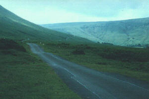 On the steep
section I met a bicycle tourist from Canada traveling in the opposite direction.
He cycled up from Abergavenny the previous day and had spent the night at
the hostel on the other side of the pass.
On the steep
section I met a bicycle tourist from Canada traveling in the opposite direction.
He cycled up from Abergavenny the previous day and had spent the night at
the hostel on the other side of the pass.
There is a parking area before the pass. There were several cars there.
Some people hike to the top of Hay Bluff while others hike up and jump off
with their parasails. There were two parasails flying this morning. They
must have been finding some thermals as they were obviously higher than
the summit. I continued on to the pass and started down the other side.
The Vale of Ewyas side of the pass is not as steep as the Hay-on-Wye side.
I rode about two and one half miles before coming to Capel-y-ffin. The map
showed a monastery on a side road here and indeed there was but the ruins
were on private property. I took a few photographs and started back for
Gospel Pass.
The ride back up to the pass was definitely easier from this side. I stopped
at the pass and had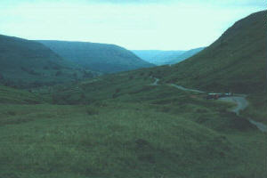 the lunch items I had purchased
earlier. A very nice place for lunch- breezy and cool with a tremendous
view of the border lands. From the pass I was able to roll the five miles
into Hay-on-Wye with less than twenty pedal strokes.
the lunch items I had purchased
earlier. A very nice place for lunch- breezy and cool with a tremendous
view of the border lands. From the pass I was able to roll the five miles
into Hay-on-Wye with less than twenty pedal strokes.
I stopped at the Tourist Information Center when I saw a loaded bike leaning
against the building. A short time later the rider appeared. Lee was in
his twenties. He had been born in Wales, but his parents then moved to Austrailia.
He enjoyed dual citizenship. He was able to take employment in Great Britian.
Lee would work two jobs for six months and then take four or five months
off and bicycle tour. He was on his way back to London. I returned to the
campgrounds and a short time later Lee pedaled in and set up. I enjoyed
hearing the accounts of the many tours he had done on the continent. Mileage
today 21
Day 8 Thursday, July 8
The morning was cool and the low clouds made it feel earlier than it
was. I was heading towards Abergavenny today. Lee planned to go through
there as well, but his plans were to use the route through Gospel Pass that
I had ridden yesterday. I had looked at the map and had chosen a route that
swung west and had fewer contour lines to cross.
I chose a road that followed the Brecon Beacons National Park Boundry and
ended at the A 4078 just outside Talgarth. From Talgarth I followed the
B 4560 through Llangorse. The low morning clouds had burned off and it turned
sunny and warm. Right before Bwich the B 4560 runs with the A 40(T) for
a short distance. Upon leaving the A 40(T) it drops down a steep hill, crosses
the River Usk as well as the Monmouthshire and Brecon Canal just outside
Llangynidr. I turned east on the B 4558 which ran along the canal for about
5 miles before ending at Ffawyddog.
 I probably would have been wise to cross the
river again at Ffawyddog and make my way through Crickhowell and follow
the unnumbered lane that ran around the north side of Sugar Loaf (596m).
I didn't, however, and instead chose to ride the A 4077. The A 4077 itself
wasn't bad but after about 3 1/2 miles it ended at Gilwern and the A 465(T).
It had heavy traffic including a high volume of lorries (trucks). I didn't
feel as though I was in danger so much as it was just uncomfortable. I had
to ride it for about 4 miles before turning onto the A 4042(T) and made
my way into Abergavenny. I had ridden the 30 miles from Hay-on-Wye in three
hours.
I probably would have been wise to cross the
river again at Ffawyddog and make my way through Crickhowell and follow
the unnumbered lane that ran around the north side of Sugar Loaf (596m).
I didn't, however, and instead chose to ride the A 4077. The A 4077 itself
wasn't bad but after about 3 1/2 miles it ended at Gilwern and the A 465(T).
It had heavy traffic including a high volume of lorries (trucks). I didn't
feel as though I was in danger so much as it was just uncomfortable. I had
to ride it for about 4 miles before turning onto the A 4042(T) and made
my way into Abergavenny. I had ridden the 30 miles from Hay-on-Wye in three
hours.
I stopped at the Tourist Information Center to ask about campgrounds further
down the road. I then made my way to the town center and looked for something
to eat. About three blocks of the main street through the central business
had been turned into a pedestrian mall. I was able to get a tuna baguette
at a bakery and two large bottles of Coke for 99p at the Woolworth store.
The Woolworth stores had provided the best prices on chocolate bars and
"fizzy drinks" during the whole trip.
I felt much better after having something to eat and drink, but was too
full to set off again. I also was enjoying Abergavenny
too much to leave just yet. I had read that a church in this town had some
of the best memorials (statuary) in this part of Great Britian. I was directed
to St. Mary's Church. As I walked in I was greeted by Miss Pauline Sheen
and she immediately started to tell me all about the church. I interupted
her long enough to tell her that I needed to secure my bike which was just
outside the door. She insisted I bring it into the church and told a gentleman
who was working with her to watch it while she took me around the church.
It was interesting to hear the detailed history of the church and its role
in the community as well as view the numerous memorials. She was a sweet
lady of about 80 and when I told her that her name didn't sound Welsh she
laughed and said she wasn't Welsh- she was Irish. She explained, "the
Welsh aren't seamstresses and the Irish are, I came here as a girl to work
as a seamstress."
was enjoying Abergavenny
too much to leave just yet. I had read that a church in this town had some
of the best memorials (statuary) in this part of Great Britian. I was directed
to St. Mary's Church. As I walked in I was greeted by Miss Pauline Sheen
and she immediately started to tell me all about the church. I interupted
her long enough to tell her that I needed to secure my bike which was just
outside the door. She insisted I bring it into the church and told a gentleman
who was working with her to watch it while she took me around the church.
It was interesting to hear the detailed history of the church and its role
in the community as well as view the numerous memorials. She was a sweet
lady of about 80 and when I told her that her name didn't sound Welsh she
laughed and said she wasn't Welsh- she was Irish. She explained, "the
Welsh aren't seamstresses and the Irish are, I came here as a girl to work
as a seamstress."
By the time I had gotten the grand tour I was ready to hit the road again.
I left Abergavenny
on the same road I had entered and was planning on riding to Monmouth and
down the Wye Valley to Chepstow. Several of the hikers had told me it was
a beautiful area. Outside of Abergavenny I got on the B 4598 which ran along
side the A 40(T) which was four lanes now.
There was a bike lane along this route and it was the only one I came across
during the entire trip. Even after the B 4598 turned south to head towards
Usk the bike lane carried on along the unnumerbered road that I took towards
Raglan. I don't know how this particular stretch of road rated a bike lane
as it didn't have much traffic which was probably due to the A 40(T) being
nearby. The bike lane continued all the way to Dingestow. 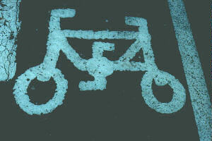 The great thing
about the bike lane is that it was marked with hand drawn sketches of bicycles.
Some of them seemed to have been drawn by persons who were unfamiliar with
what bicycles looked like!
The great thing
about the bike lane is that it was marked with hand drawn sketches of bicycles.
Some of them seemed to have been drawn by persons who were unfamiliar with
what bicycles looked like!
The route was fairly flat, and truthfully a little boring. The B roads tend
to be a little less interesting for me. It skirted close to a service plaza
on the A 40(T) which had a BurgerKing so I stopped and had something to
eat. It was getting hot and it was nice to get into the air conditioned
building. It was a little odd being a bicycle tourist in the service plaza
of a four lane highway.
I rode on to Raglan and bought food for my evening meal and asked about
campgrounds. I was given directions to one in Dingestow about six miles
down the road. I wasn't ready to stop for the day but I was trying to look
for a place I might stay Saturday night. If I caught the train in Abergavenny
at noon on Sunday a ride from this area was reasonable. I checked out the
campgrounds and while it seemed to have a large number of caravans (travel
trailers) and few tents it was clean.
From the campgrounds I got on a lane that climbed towards Worthbrook. I
was at 47 miles for the day and I realized I was running out of steam. I
was also running out of water and stopped to ask for some at a house where
I saw someone in the yard. As I waited for her to return with the water
I realized how good it felt to rest in the shade. I rode another five miles
into Monmouth where I checked out another campground. The owner said they
get very busy on weekends and usually fill up. He didn't seem like he would
be inclined to find room for a bicycle tourist with a small tent if I didn't
get there early.
I stopped at the Tourist Information Center to try to get some information
on the Wye Valley. I was interested in seeing the Tintern Abbey which was
about 10 miles down the valley from Monmouth. My map had run out just before
reaching Monmouth and I wanted to take a look at the OS Landranger for this
area and they always seemed to be available at the information centers.
I wasn't interested in spending 5.25 B.P. for a map that I wouldn't be getting
too much use out of. The people at the information center allowed me to
look at it and make additions from it to a map that was part of a handout
for tourists. They told me there was a B&B on the ridge above Tintern
that also had camping space. They gave me directions to the road leading
to the top of the ridge and I set off with my map and its hand drawn additions.
I had no trouble finding the B 4293 that lead to the ridge and I began the
climb. It was hot and the road had a lot of traffic. It was twisting with
a poor field of vision so I had a number of tense moments with cars approaching
rapidly from behind. I was slow and in the 2 1/2 mile climb I had to stop
to rest three times and I felt nauseated. I had failed to fill my water
bottles before setting out from Monmouth and I ran out of water. Once on
the top I got off of the B road and was able to ask directions to the B&B.
I am still amazed that unless a road has an A or B designation it doesn't
have a name or number. It might be the "Road to Whitebrook" when
given in directions on how to get somewhere. Also the houses along a lane
don't have numbers like I am used to. The houses have names. So you might
be looking for Heather Cottage on the road to Whitebrook. But perhaps not
everyone knows where Heather Cottage is! You hope you find someone who does
and usually as you get closer to Heather Cottage the people you ask know
where it is. I would bet that it is a difficult job to be a substitute mail
delivery person in rural Great Britian.
I finally found the B&B and they did indeed have a campground. I was
the only camper there and after paying the 3 B.P. fee began to set up camp.
I was very tired. I actually had a difficult time getting the tent up and
locating things in my panniers. I took a shower and after washing out the
cycling clothes I realized that I had put on my dirty shorts and washed
my clean ones. I wasn't functioning at a very high level. It wasn't until
the next day that I realized that I was probably dehydrated. It had been
a very hot day and I wasn't drinking enough. The long hard climb shouldn't
have been that hard and the nausea should have been a warning flag if my
mind had been sharper.
After eatting, drinking, and resting I began to feel better. I decided to
take advantage of the opportunity to wash my bike up. I had a week's accumulation
of dirt and sheep droppings on the tires and frame. I had heard stories
of airlines personel refusing to accept bikes that were not reasonably clean.
I carry Woolite for most of my soap needs, although I don't like to use
it as a shampoo unless it becomes necessary. The Woolite worked wonders
on those sheep droppings. In a short time all traces were removed from tires
and frame. I hope to find the time to write to the good people at Reckitt
& Colman and sing the praises of Original Woolite Fabric Wash. How fitting
that it not only does a good job of cleaning wool, but it also does a great
job of cleaning up after the animals as well!
Feeling in need of a little strength I made my way to the local pub. While
indulging myself I checked out an OS map that was kept behind the bar. I
assume it was kept there for bicycle tourists such as myself who were too
cheap to buy them at the Tourist Information Center. Thanks to the map and
the interested patrons I left the pub with precise directions on how to
descend from the ridge into Tintern the next morning. Mileage today 59.
Day 9 Friday, July 9
I realized this morning that last night was the first night that I hadn't
gone to sleep to the sounds of sheep. I had seen large numbers of cows in
the ride up to the ridge, but no sheep. I washed the shorts that I thought
I had washed out yesterday so now I had one pair of wet shorts and another
pair that was damp. I killed a little time by laying in the tent and reading.
I had some breakfast and read a little more. I finally decided it was time
to pack up and hit the road. I pulled on the damp shorts and rode out about
10:30.
The ride to Tintern was a diagonal route down the side of the valley wall.
It was easy to see why the hikers liked the trail along the Wye Valley so
much. It was mostly woods and while there weren't grand vistas to gaze out
over it was certainly beautiful in a "Sherwood Forest" sort of
way. The 7 mile ride into Tintern was a quick one. It was a short ride south
along the A 466 to the abbey.
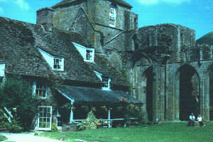
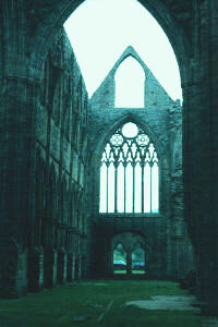 Tintern Abbey was founded in 1131. The Cistercian
Monks existed for 400 years before Henry VIII's dissolution of the monastery
in 1536. The ruins are of a magnificient collection of buildings whose preservation
continues today.
Tintern Abbey was founded in 1131. The Cistercian
Monks existed for 400 years before Henry VIII's dissolution of the monastery
in 1536. The ruins are of a magnificient collection of buildings whose preservation
continues today.
Rather than climb the distance back to the top of the ridge I decided to
return to Monmouth using the A 466. Yesterday's ride was still fresh in
my mind and even though it was cooler and overcast this morning I wasn't
up to a hard climb. It was a 10 mile ride along the Wye River back into
Monmouth.
Even though it appeared to be slightly inclined in my favor it wasn't an
easy ride. The traffic wasn't as heavy as I would have anticipated for the
main road between Chepstow and Monmouth. I decided that perhaps the extra
effort that seemed to be needed this morning was due to low tire pressure.
They didn't look or feel low under the thumb, but at the edge of Monmouth
I saw an auto service facility with an air hose outside. Of course I carry
a pump, but a compressor makes a quick and easy job of it. When I asked
the manager told me to go right ahead and help myself. I had tried to air
up my tires at a service station in Presteigne and had only managed to flatten
the tire as I applied the air chuck. The Schrader adapter that I normally
used wouldn't seal up with the air chuck and simply let the air out of the
tire. I solved that problem by asking to borrow a replacement valve stem
and pressing the Schrader adapter into the end that normally attaches to
the wheel of the car. I then screwed those assembled pieces onto the Presta
stem on the bike. I could then apply the air chuck to the valve stem and
inflate the bike tire. As I examined the air chuck at this particular facility
I found it to be just like the one I had encountered in Presteigne. I explained
the problem to the service manager and he gave me a replacement valve stem
and told me to put it in my tool kit. In Presteigne I assumed that the air
chuck was in need of a new seal or perhaps replacement. After the second
experience I had to assume that is just the design of some of the air chucks.
After maximizing the tire pressure the bike seemed to roll a lot easier,
but whether it actually did or not is debatable.
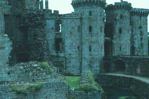 I stopped long enough in Monmouth to purchase
a bunch of bananas at one of the market stalls and rode on towards Raglan
on the same road that I had ridden down the day before. I stopped at Raglan
Castle which dates from 1435- almost 200 years after the fortresses built
further north. It was built more as a statement of wealth than as a military
installation. In 1646 it did, however, endure one of the longest seiges
in the Civil War. It finally fell to Cromwell's forces and suffered from
the acts of his demolition teams. Even in ruin its beauty is evident.
I stopped long enough in Monmouth to purchase
a bunch of bananas at one of the market stalls and rode on towards Raglan
on the same road that I had ridden down the day before. I stopped at Raglan
Castle which dates from 1435- almost 200 years after the fortresses built
further north. It was built more as a statement of wealth than as a military
installation. In 1646 it did, however, endure one of the longest seiges
in the Civil War. It finally fell to Cromwell's forces and suffered from
the acts of his demolition teams. Even in ruin its beauty is evident.
When I stopped in Raglan I had a conversation with a gentleman concerning
my route. He told me I had missed a beautiful area when I had turned around
and headed back to Hay-on-Wye after going over Gospel Pass. I looked at
the map and saw that the Vale of Ewyas was the name of the valley and it
would be a good ride for the next day from Abergavenny.
I rode back to Abergavenny and stopped at the Woolworth store to take advantage
of the two Cokes for 99p sale. I rested in the shade at the pedestrian mall
area and engaged in some people watching before heading for the campgrounds
about 2 miles west of town.
The campgrounds were nearly full and most of the campers were in caravans
rather than tents. I paid for two nights (2.50 B.P./night) and found a site
beside two Dutch bicycle tourists. It was only their second day on the road
after leaving Holland on a bus and being dropped off somewhere near Chepstow.
They were using automobile maps and soon were won over to the Ordinance
Survey Maps. I went back into Abergavenny and enjoyed some take away Indian
food in the now deserted pedestrian mall. I rode back to the campgrounds
and realized how quiet it was for the number of people who were calling
it home for the night. Mileage today 43.
Day 10 Saturday, July 10
This was to be my last full day of riding. I would catch the train at
the Abergavenny station just after noon tomorrow. The weather was beautiful.
I was still planning on riding up the Vale of Ewyas to Capel-y-ffin which
had been my turn around point when I had ridden over Gospel Pass.
On the way into Abergavenny I had to ride a short distance on the A 40(T).
The lane that intersected the A road did so at a diagonal. As I left the
lane and was crossing to the other side of the A road I turned to the sound
of a lorrie approaching to my left. The lorrie was still quite a ways down
the road (out of sight around a curve in fact). When I looked back I realized
I was traveling faster than I thought I had been and I was quickly approaching
the curb at an impossible angle. Jumping it didn't seem to be an option
and hitting it was going to damage the equipment. I turned the wheel to
minimize the angle with the curb and prepared to go down. I didn't hit very
hard, but the solid contact with the curb stopped the forward motion of
the bike and did little to slow mine. The sidewalk had a tar and chip type
of surface and the initial glimpse of it caused all the bells and whistles
in the self preservation center to go off. I had to make every effort to
keep my skin from coming into contact with that sidewalk. My gloved hands
made contact first and then my feet. Without realizing it my feet had cleared
the toe clips and I was scrambling across the sidewalk on all fours. If
anyone witnessed my crab dance across the sidewalk it must have been very
entertaining for them. I had managed to keep my body up and off of the sidewalk.
I straightened up and ran back to grab my bike and pulled it onto the sidewalk.
I gave it a quick onceover and then continued on my way only to realize
that I was no longer wearing my sunglasses. I turned around and pedaled
back to find them on the roadway undamaged. I had dodged a bullet in what
could have spoiled my last day of riding.
In Abergavenny I found the road north and began a 3/4 mile climb. I was
able to avoid the main road traffic by weaving my way along various narrow
lanes and after a few miles was headed up the valley. The road was narrow
and went through farmland. The traffic was very light. It was an absolutely
glorious day in rural Wales.
 Lantonney Priory has a beautiful location in
the valley. There is a pub housed in a portion of the priory while the rest
is in ruins. There were people camped nearby but it wasn't marked on the
map as a campground. I had seen a place further down the valley that had
camping and it wasn't marked on the map either. Further up the valley towards
Gospel Pass was the hostel so finding a place to stay wouldn't be a problem.
I passed a large group of pony trekkers on the road and many hikers could
be seen on the trail leading up to the ridge high above the priory.
Lantonney Priory has a beautiful location in
the valley. There is a pub housed in a portion of the priory while the rest
is in ruins. There were people camped nearby but it wasn't marked on the
map as a campground. I had seen a place further down the valley that had
camping and it wasn't marked on the map either. Further up the valley towards
Gospel Pass was the hostel so finding a place to stay wouldn't be a problem.
I passed a large group of pony trekkers on the road and many hikers could
be seen on the trail leading up to the ridge high above the priory.
Just beyond the priory I stopped and placed a Guinness in a stream to be
chilled for my lunch on my way back down the valley. I continued on to Capel-y-ffin
before turning around to retrace my route.
I stopped to pick up the Guinness and rode back to a shaded spot along the
lane. I sat on some stone ruins and enjoyed my lunch. Another group of pony
trekkers rode past and then a woman leading a mare approached along the
lane. 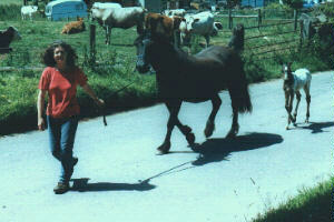 Following the mare was a very young colt- handsome
as all week old colts seem to be. After finishing my lunch I explored the
area just behind my location and found a small fenced field with two more
mares with their colts. The woman there to check on them told me that the
youngest colt was less than a day old.
Following the mare was a very young colt- handsome
as all week old colts seem to be. After finishing my lunch I explored the
area just behind my location and found a small fenced field with two more
mares with their colts. The woman there to check on them told me that the
youngest colt was less than a day old.
I stopped at the pub in the priory and they were kind enough to fill a water
bottle for me. I rode back to Abergavenny and stopped at Woolworth yet again
for their Cokes. I found a take away fish and chips place at the edge of
the pedestrian mall and enjoyed my dinner on a bench in the still busy area.
The campgrounds were full when I returned. Lots of activity but once again
the noise level was much lower than one would have expected for a site as
full as this one was. A group of youngsters in an adjacent field was playing
a game that appeared to be baseball. The more I watched the more I was convinced
that it was in fact baseball. When I walked over and asked they said it
was a game called "Rounder" (which appears to be very much like
baseball). Mileage today 34.
Day 11 Sunday, July11
Another bright and sunny morning. I packed up the panniers at a leisurely
pace and bid the Dutch couple farewell. I had almost four hours before I
had to catch my train. I rode into Abergavenny and had coffee and a muffin
at the local Sunday morning hang out. Many roadies were meeting there for
the day's ride as well as a large number of motorcyclists. I didn't want
to get too far away from town because of the possibility of a mechanical
problem causing me to miss the train. I hadn't really ridden that much in
town so I decided to check out some of the residential areas. After coming
to the edge of town I continued on and rode up a hill that was over a mile
long. It gave me a great view of the valley that Abergavenny lies in with
Sugar Loaf mountain (596 m.) at her back. I took advantage of the opportunity
to take a few pictures before turning around and riding back into town. I continued this meandering until about 11:40 when I decided to make
my way to the train station. I moved to the platform and after packing up
the duffel spent the time reading.
I continued this meandering until about 11:40 when I decided to make
my way to the train station. I moved to the platform and after packing up
the duffel spent the time reading.
The train arrived about four minutes early and I walked my bike to the car
at the end marked with the bicycle symbol. I was told by the conductor that
the car was a "bit crowded". I asked what I should do with my
bike as I had reserved a place for it on the train. He spent a moment rearranging
some of the other "cargo" before deciding there was enough room
after all and asked me to push the bike into him.
When we arrived at Newport I found that my connecting train to Reading was
delayed. The delay ended up being 25 minutes which was too late to make
the train to Gatwick. A quick check in the office resulted in being assured
that there was another train to Gatwick an hour after my original schedule.
The train from Newport to Reading had a car at the end that had a bike rack
with room for four bicycles. I strapped it in and found a seat forward.
In Reading the arrangement was to push the bike into my passenger compartment
and prop it near the door. This was a bit of a problem in that when we arrived
at Gatwick the passengers had to exit the train on the side I had placed
my bike. I became a bit anxious at the delay of exiting the train only to
finally realize it was because my bicycle was blocking the way!
I walked the bike up to the South Terminal and stood in line at the information
booth. My questions resulted in being given a map of the footpath from the
airport to Horley. I went outside the terminal and packed my things on the
racks and pedaled the footpath which enters Horley in a residential area.
I asked for and was given directions to the part of town that had a number
of B&B's. I was a bit put off by the cost of the rooms at several places-
40 BP. Still others couldn't provide any security for the bike. I was finally
able to find a place that was able to give me a place at the back that was
in an enclosed yard and had a decorative iron railing that I could lock
my bike to for 25 BP. I walked up town and found a Chinese take away restaurant.
As I sat in my room eatting I realized that I hadn't watched TV for eleven
days and that this would be the first night in that length of time that
I had slept in a bed. Mileage today 14.
Day 12 Monday, July 12
 I awoke not to the sound of sheep or early morning
campground movements, but to the sound of an alarm clock. I went down to
the breakfast room which I would have to label as meager- obviously 25 BP
doesn't get you a full English breakfast. I retrieved my bike after eatting
and packed up for my ride to the airport.
I awoke not to the sound of sheep or early morning
campground movements, but to the sound of an alarm clock. I went down to
the breakfast room which I would have to label as meager- obviously 25 BP
doesn't get you a full English breakfast. I retrieved my bike after eatting
and packed up for my ride to the airport.
I retraced my ride along the footpath and made my way to the busy North
Terminal. I found a spot beside a vending machine and proceeded to prepare
the bike for boxing up. I packed my duffel and made up a carryon bag. I
pushed my bike to Delta's area and asked that the bike box that I had reserved
on July 1 be brought up. It had only been by chance that I had asked about
a box when I was at the airport to see my family off. They said I would
be welcome to a box if in fact they had any when I needed it! Apparently
they sometimes have boxes while other times they don't. I asked them to
check on the availability of a box and when the man returned he informed
me that they had in fact had just one box available. He had put my name
on the box and I was to ask for it when I checked in. The box was still
there and quickly brought to me. It is my understanding that there is a
place in the airport that sells bike boxes for 17 BP, but I wasn't eager
to pay for something that is normally provided free.
Two airline employees assembled the box, and after inserting the bike, taped
it shut for me. They told me to proceed to the Business Class check in which
was a real bonus this morning because there were a minimum of 200 people
ahead of me in line for Coach. I was immediately checked in and once again
there was no charge for the bicycle. I went to the gate and as I watched
the people waiting to board I knew that many of them were returning home
after a vacation holiday in Great Britain. I was sure that I would have
had a hard time believing that anyone of them had had a vacation as enjoyable
as the one I had in the preceeding ten days. Mileage today 2 (which brought
me to 400 for the tour).
Back to Homepage