July 1997
I've recently returned from a month in Hawaii that included time on a
bicycle. The trip was a three week family vacation that I was able to extend
for an additional week for myself to bicycle, camp, and visit friends. We
spent two weeks on Maui before going to the Island of Hawaii for a week.
I then returned to Maui for a week after my wife and sons flew home.
I lived on Maui for a year in the 70's. I taught school in Hana on the windward
(East) side of the island. We were last on Maui three years ago at which
time I did my first bicycling there. At that time I took an older three
chainring Trek that I set up for touring and while it was up to the task
there were some areas that I avoided because I couldn't get anything larger
than 700 x 32 tires to fit. Shortly after our return Nashbar had a clearance
on mountain bikes and I was able to ship one to a friend for a total cost
of $265.00. The idea was that each time I used the mountain bike I saved
$100 by not having to travel with my touring bike on the airline (there
is no such thing as ground shipping on UPS to Hawaii- round trip shipping
would exceed the $100 the airlines charge). So I have a mountain bike at
my disposal whenever I can make it to Maui.
I still had a rather large amount of equipment to transport as baggage. I took my helmet, a Brooks saddle, pedals, a rear rack, front lowrider pannier rack, barends, computer, handlebar bag, pump, and four Nashbar front/rear panniers. I also took a pair of Nimbus 1 1/2 x 26 tires.
We spent the majority of time in a condo in Kihei. Kihei has a lot of condos and resort hotels because of its dry sunny climate (due to its leeward position). I would ride early in the morning- temperatures were usually 70 degrees at 5:30 AM, in the low 80's by 8:30 and ranged 85 to 90 by 10:30. Early morning rides also don't have to contend with the tradewinds of late morning and afternoon. The trades were gusting to 30 mph the whole time we were there while 10 - 15 mph would be considered normal. Riding in a northeasterly direction after 10:30, especially in the central plain between the two mountain groups (one could hardly call them ranges) can be difficult.
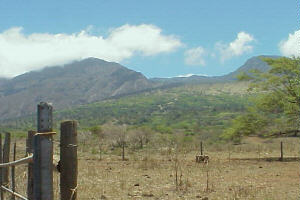
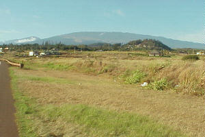 Maui has a population of 105,000 and has an area
of 728 square miles. East Maui consists of about 4/5's of that area and
is dominated by Haleakala (House of the Sun) a dormant volcano that rises
to 10,025 feet at its summit. It is 38 miles to the ocean from the summit-
the shortest distance anywhere in the world to go from sea level to that
elevation. Numerous outfitters use that downhill run to provide thousands
of tourists the opportunity to coast 38 miles and say they biked a volcano.
There is also an annual race UP Haleakala called Race to the Sun. It goes
from Paia on the north shore to the summit. The record is 2 hours and 38
minutes held by a professional racer whose name escapes me. Competitive
times for mere mortals is in the 4 hour range.
Maui has a population of 105,000 and has an area
of 728 square miles. East Maui consists of about 4/5's of that area and
is dominated by Haleakala (House of the Sun) a dormant volcano that rises
to 10,025 feet at its summit. It is 38 miles to the ocean from the summit-
the shortest distance anywhere in the world to go from sea level to that
elevation. Numerous outfitters use that downhill run to provide thousands
of tourists the opportunity to coast 38 miles and say they biked a volcano.
There is also an annual race UP Haleakala called Race to the Sun. It goes
from Paia on the north shore to the summit. The record is 2 hours and 38
minutes held by a professional racer whose name escapes me. Competitive
times for mere mortals is in the 4 hour range.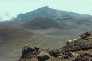
I had decided I wanted to bike around East Maui. In a trip to a LBS (Extreme Sports Maui) in Kahului I met Ron Mayle. Ron is the mechanic there and used to have his own bikeshop in Paia. He has ridden around East Maui 54 times. 52 of those were done counterclockwise and he said it is the only way to go. The total distance is 107 miles. The ride represents a total gain of 8340 feet in elevation. All 54 rides were solo and on Sunday- his day off from running his bikeshop.
I left Maui for six days to fly to the Big Island (Hawaii) with my family and returned to spend the week after they went home. I had to leave my bike and gear someplace secure and that happened to be in Kula about 18 miles up Haleakala at about 3000 feet elevation. My ride began there at about 6:00 PM. one early evening. In order that anyone who might be interested in duplicating my route beginning at the airport in Kahului will have complete directions I will begin at the airport in describing the ride and giving mileage.
It should be noted that Maui is not particularly interested in "visitors" who aren't spending big bucks for a resort hotel or vacation condo, and a rental car. This is apparent in the limited number of campgrounds available on the island. Some areas are prime for guerilla camping while others would be dangerous or provoke arrest. There are three different agencies responsible for administering campgrounds on Maui. They are the County of Maui, the State of Hawaii, and the National Park Service. Both the county and the state require permits for campsights, however, those permits are not available at any of the campsights!! They must be obtained from the appropriate offices in Wailuku prior to your intended camping. The best way is to apply to the correct office via mail prior to arriving on the island. If anyone needs information on how to do that email me and I will provide the correct addresses to obtain your application. The county currently has only one campground in use, but it is an important one because it is less than a mile from the airport. The cost is $3.00 a day per person with a three consecutive day limit. The state has two campgrounds, one at a beautiful location just outside of Hana (Waianapanapa) and another 6000 feet up the slopes of Haleakala (Poli Poli Springs). State permits are free. The National Park Service has two sites; one at Hosmer Grove (elevation 6500 feet), another at Oheo Gulch, located (at sea level) 10 miles from Hana. No permit or charge for camping in the National Park.
Riding East Maui
Kahului Airport is only about a mile from town, so any equipment or supplies
you might need to pick up there will not be out of your way. Making your
way to Kanaha Beach Park (with the camping permit you obtained before arrival)
is as easy as pedaling on the one way terminal loop until you see the sign
for rental car returns (Koeheke St.). Proceed beyond the return area to
the stop sign and turn right (Amala St.) and then left into the parking
area of Kanaha Park. 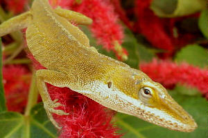 The camping area is between
the parking lot and the beach. Most beaches with facilities have outdoor
freshwater showers, but you may have to look up or down the beach for them.
The camping area is between
the parking lot and the beach. Most beaches with facilities have outdoor
freshwater showers, but you may have to look up or down the beach for them.
From Kanaha Beach retrace your route to the terminal loop and head towards town. Mileage begins at the airport loop. Turn left at KMart onto the Hana Hwy. (Route 360) which has a very wide shoulder/bike lane.
Mile 3.5 Turn right onto Haleakala Hwy. You are beginning a 15 mile ascent that will climb 3000 feet. Good shoulder and road surface. The next 6 miles will be through sugar cane fields.
9 Pukalani turn off. Pukalani is a small town that has a Foodland, MacDonalds, one or two diners, and a gas station. While you won't need any of the $1.79 a gallon gas; perhaps a bit of air? Diminished shoulder until returning to the highway.
11.5 Turn right at the light and you continue your climb towards Kula San.
15.5 Turning left will quickly bring you to a gas station/store, back out on the highway the Kula Post Office is just ahead.
18 The last of the steady climbing is behind you and the ride becomes much more interesting. The next 80 miles will range 3000 feet in elevation and take you through desert and rain forest. You owe it to yourself to kick back and soak it in. Ron Mayle's day ride deserves a week of your life.
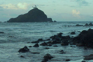
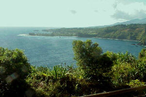
21 Keokea- this area has a gallery, gas station, store, and Grandma's. Grandma's is one of the nicest coffee shops on Maui. They grow and roast their own coffee and the baked goods are outstanding. Very casual relaxed atmosphere enjoyed by locals. Several turnouts on the road after Keokea give you a view of the coastline at Kihei as well as West Maui beyond. Kahoolawe is the island off of the coast of Maui to the west. For years the US Navy used it for bombing practice, it currently has no human inhabitants (but many goats) and the Hawaiians want it back. From Keokea a beautiful twisting 5 mile descent through pastureland to 2000 feet. Road surface is still excellent but the nice wide shoulder is shrinking, very light traffic.
26 Ulapalakua- Last chance for food and water for 20 miles. This is the headquarters for the Ulapalakua Ranch. The store also has a deli and serves light lunches (I believe it closes by 5:00) Just beyond is the Tedeschi Winery and its tasting room. Shortly after leaving Ulapalakua you enter the driest part of the island. You will also be riding into the tradewinds but they are offset by the mostly downhill ride to the ocean for the next 16 miles. Very few houses will be along the next 30 miles. Very little opportunity to camp along the stretch between Ulapalakua and 14 miles beyond. The road is through vast stretches of lava flows with short brush and grasses. Its surface has taken on the appearance of a patch work quilt. There are very few potholes, but the road appears to have been layed down a few shovelfuls at a time. Cattle graze here and wander the road on yet another ranch (Kaupo Ranch). To your left the slopes of Haleakala rise to 10,000 feet with (depending on the weather) the white buildings of Science City clearly visible. To your right 30 miles south is the island of Hawaii with its two 13,000 foot volcanos usually visible above the clouds gathered at their bases. I rode this stretch after sunset- which means in the dark. There is very little twilight in Hawaii. Unable to find a campsight I rode along using my mini-mag for illumination. I saw six barn owls in a short period of time. I was able to find a camping spot between mileposts 25 and 26.
37 There was room to push my bike between the gate and fence. The sign declared this area to be Hawaiian Homestead Lands. There was a Jeep trail leading down towards the ocean and I followed it down far enough to make sure that my tent's yellow and blue rainfly wasn't visible in the lights of any latenight traffic on the road. I didn't want to spend any vacation time debating a truckload of cowboys about the merits of my camping on what was essentially private land. It was 8:15 and I had traveled 24.5 miles since 6:00. It was in the low 70's under crystal clear skies, the lights of the Big Island clearly visible as was the beacon at Upolu Point. An occasional gecko interupted the faint sound of the surf about a mile away and 500 feet below my position. I was up by 5:30 and quickly packed up and made my way to the road and reached the ocean shortly thereafter.
42 I reached a stone beach and the surrounding area was covered with the first vegetation that was over 30 inches in height since leaving Ulapalakua. A grove of trees 20 feet tall ran along a wide gulch all the way to the beach. While gathering sticks for a fire to cook some breakfast I marveled at the thorns some of them displayed. This area was probably used a lot for weekend camping by the locals and in fact was large enough to host a goodly number of campers without invading anyones space.
 43 I encountered a short but very stiff climb.
I had to WALK it. I consoled myself by telling myself no one had seen me
do it. The stock mountain bike gearing is a bit higher than my Sequoia,
but I feel I would have walked this one and a couple to follow with the
Sequoia as well. I had a pickup truck slow down as it passed me and the
driver offered to give me a ride. I politely declined and quickly explained
that I was there for the bicycle ride. I could see the explanation delighted
the passenger who was an older Hawaiian gentleman.
43 I encountered a short but very stiff climb.
I had to WALK it. I consoled myself by telling myself no one had seen me
do it. The stock mountain bike gearing is a bit higher than my Sequoia,
but I feel I would have walked this one and a couple to follow with the
Sequoia as well. I had a pickup truck slow down as it passed me and the
driver offered to give me a ride. I politely declined and quickly explained
that I was there for the bicycle ride. I could see the explanation delighted
the passenger who was an older Hawaiian gentleman.
45.5 The pavement ends here and the road becomes a varying dirt/cinder/stone surface for about five miles. Several places in that five miles reverts back to hard surface in areas that would be subject to washing during heavy rain.
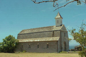 46 St. Joseph's Catholic Church- built in 1862
and most recently restored in the early 1990's.
46 St. Joseph's Catholic Church- built in 1862
and most recently restored in the early 1990's.
46.5 Kaupo Store- I'm sorry I don't know when the Kaupo Store was established, but it has been around for quite some time. I had intended to get a little of the history of the place when I stopped here to get water and purchase the first cold drink of the day. I arrived at 9:00 AM and wasn't surprised to find it closed. Any traffic that was on this portion of the road probably wouldn't amount to much until late morning. I settled in on the front porch to wait. I had started from Keokea with 2 1/2 liters of water and I was now down to about a 1/4 liter. The morning was beautiful and I didn't mind sitting on the porch waiting for the store to open. I found a papaya tree with a ripe fruit and enjoyed it while I waited. By 10:00 the novelty of sitting on the porch was wearing thin and by 10:30 I had had enough. I began poking around for a source of water. I found a spigot on some nearby property and filled my bottles. I treated it with the tablets I was carrying because it obviously wasn't "city water" on this part of the island. You only ever have to get sick from bad water once in your life to become very particular about unknown water sources. Iodine tablets aren't a guarantee, but provide some measure of effectiveness in an emergency. I had planned to stash water in this area before leaving for the Big Island, but the road had been closed between here and Hana due to high water from runoff caused by heavy rains in the mountains. As I prepared to leave the Kaupo Store I realized I had flatted. The first and only flat of the ride. I had whiled away an hour and a half only to find that one of those thorns that had so intrigued me at mile 42 had hitched a ride in my front tire.
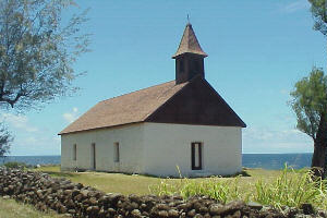 47.5 Hui Aloha Church built in 1859. This stretch
of road has sections that are perched on the side of the cliff with sheer
drops into the ocean. Prudent drivers sound their horns before entering
the steep bends and curves. Seals can sometimes be seen lounging on the
beach of the bay below the overlook, however, today I didn't see any.
47.5 Hui Aloha Church built in 1859. This stretch
of road has sections that are perched on the side of the cliff with sheer
drops into the ocean. Prudent drivers sound their horns before entering
the steep bends and curves. Seals can sometimes be seen lounging on the
beach of the bay below the overlook, however, today I didn't see any.
50 The pavement starts again and I reach my first fruit stand. People who have extra fruit sometimes have stands along the road. Most often they are run on the honor system or by children. Bananas (apple variety: smaller, firmer, tastier), passion fruit, and papaya are common offerings.
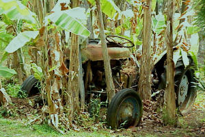
51 This area is called Kipahulu. Sugar production was the draw here between 1890 and 1922. When sugarcane harvesting become mechanized production ceased in Kipahulu because of the machinery's inability to work in the local terrain. The mill ruins can be seen on the left at about mile 52.
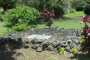 53 Palapala Church- the sign is small and is
difficult to see when riding this direction. The church sits well off of
the road. It's a beautiful little church built in 1857. The quiet little
cemetery contains the grave of Charles A. Lindbergh. Lindbergh loved Hana
and spent a considerable amount of time there in the 1970's. When he realized
his life was nearing its end he chose to spend the last of his days in Hana.
The carpenters at the Hana Ranch (per his instructions) assembled a simple
coffin made from local eucalyptus. He asked to be buried in a set of work
clothes and he was layed to rest after a small ceremony in the church.
53 Palapala Church- the sign is small and is
difficult to see when riding this direction. The church sits well off of
the road. It's a beautiful little church built in 1857. The quiet little
cemetery contains the grave of Charles A. Lindbergh. Lindbergh loved Hana
and spent a considerable amount of time there in the 1970's. When he realized
his life was nearing its end he chose to spend the last of his days in Hana.
The carpenters at the Hana Ranch (per his instructions) assembled a simple
coffin made from local eucalyptus. He asked to be buried in a set of work
clothes and he was layed to rest after a small ceremony in the church.
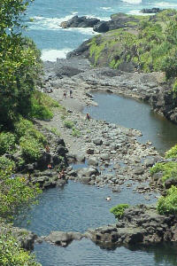 54 Oheo Gulch- This area was once called the
Seven Sacred Pools, but people came to realize that name and the associated
story was nothing more than someone's attempt to fabricate an interesting
story. This is an over used area on Maui during the summer months. By late
morning the parking lot is full and the overflow area begins to fill. It
has become a ritual for tourists to drive to Oheo Gulch from the resort
areas on the western sides of the island and return to their hotels and
condos the evening of the same day. From Kahului to Hana the Hana Highway
travels 52 miles. In that stretch there are 56 one lane bridges and a reported
617 curves. The distance from Hana to Oheo Gulch is another 10 miles with
numerous bridges and many more curves. It is a very beautiful area. The
stream flows down from the rainforest in the Kipahulu Valley. It creates
a series of natural rock pools of freshwater before flowing into the ocean.
The lower pools are packed with people in the afternoon.
54 Oheo Gulch- This area was once called the
Seven Sacred Pools, but people came to realize that name and the associated
story was nothing more than someone's attempt to fabricate an interesting
story. This is an over used area on Maui during the summer months. By late
morning the parking lot is full and the overflow area begins to fill. It
has become a ritual for tourists to drive to Oheo Gulch from the resort
areas on the western sides of the island and return to their hotels and
condos the evening of the same day. From Kahului to Hana the Hana Highway
travels 52 miles. In that stretch there are 56 one lane bridges and a reported
617 curves. The distance from Hana to Oheo Gulch is another 10 miles with
numerous bridges and many more curves. It is a very beautiful area. The
stream flows down from the rainforest in the Kipahulu Valley. It creates
a series of natural rock pools of freshwater before flowing into the ocean.
The lower pools are packed with people in the afternoon. 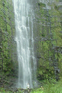 There is a nice
hike from the parking lot that will take you to Waimoku Falls. It is about
2 miles to the falls and takes about an hour. It is about a 900' gain in
elevation. The trail can be muddy in places. My favorite stretch is the
section that goes through the bamboo forest.
There is a nice
hike from the parking lot that will take you to Waimoku Falls. It is about
2 miles to the falls and takes about an hour. It is about a 900' gain in
elevation. The trail can be muddy in places. My favorite stretch is the
section that goes through the bamboo forest.
While a lot of people come here each day not many of them enter the campgrounds. The campground is reached by turning off of the road at the entrance to the overflow parking lot and continuing through the parking lot , following the dirt road down the hill. It is a primitive site - modern pit toilets and no water. Seems unbelievable that the National Park Service would have a campground with no water. They have had the wells drilled for some time (years!) but are just this summer piping the water to the site. Something to do will land acquisition and right of ways (i.e. politics). I had water stashed here for my use but in the past have obtained water at the stables you passed just prior to arriving at Oheo Gulch (and, yes, I treated it). The campgrounds are not over used, but weekends are busier. Should you need it there is a public telephone in the main parking lot.
 The reason this area is so green and lush (beginning
in Kipahulu) is because of its location in relation to the prevailing tradewinds.
As the trades reach land and start up the cooler slopes of Haleakala their
moisture falls out. This is the windward side of the island and you will
continue to ride through a tropical landscape for the next 50 miles or so.
Normal summer weather patterns in this area would be for morning and evening
showers with beautiful, breezy, sunny days (although humidity can be high).
This summer, however, has not been typical. It has been a wet summer. Showers
every few hours are not uncommon- depending on where you are. I never used
my rainjacket- the temperatures will range from 75 to 85 degrees- you can
get wet from the rain or from wearing a jacket in those temeratures. The
rain comes with the territory; cover your Brooks and enjoy it. No rain,
no rainbows.
The reason this area is so green and lush (beginning
in Kipahulu) is because of its location in relation to the prevailing tradewinds.
As the trades reach land and start up the cooler slopes of Haleakala their
moisture falls out. This is the windward side of the island and you will
continue to ride through a tropical landscape for the next 50 miles or so.
Normal summer weather patterns in this area would be for morning and evening
showers with beautiful, breezy, sunny days (although humidity can be high).
This summer, however, has not been typical. It has been a wet summer. Showers
every few hours are not uncommon- depending on where you are. I never used
my rainjacket- the temperatures will range from 75 to 85 degrees- you can
get wet from the rain or from wearing a jacket in those temeratures. The
rain comes with the territory; cover your Brooks and enjoy it. No rain,
no rainbows.
A fairly strong band of showers came through as I was packing up after my night at Oheo Gulch making it difficult to get things ready to go. I use a Eureka two man tent with a very small vestibule, but no tent is large enough when it's raining. I keep my panniers in a large heavy plastic garbage bag outside of my tent at night.
 The crush of cars doesn't really come until
late morning so if you get up and hit the road reasonably early the numerous
cars that come later in the day won't spoil the beautiful 10 mile ride into
Hana. The closer you get to Hana the more houses you will pass. There will
be more fruit and flower stands and perhaps several vendors set up at some
of the larger turnouts along the way. A mile or two from Hana the road splits
and going right will take you on a loop through Hamoa past Hamoa Beach (adding
only a mile or two). It's a very beautiful beach and like all the beaches
in Hawaii- public. There is no such thing as a private beach in Hawaii.
Even the exclusive hotels can not deny access to the beach.
The crush of cars doesn't really come until
late morning so if you get up and hit the road reasonably early the numerous
cars that come later in the day won't spoil the beautiful 10 mile ride into
Hana. The closer you get to Hana the more houses you will pass. There will
be more fruit and flower stands and perhaps several vendors set up at some
of the larger turnouts along the way. A mile or two from Hana the road splits
and going right will take you on a loop through Hamoa past Hamoa Beach (adding
only a mile or two). It's a very beautiful beach and like all the beaches
in Hawaii- public. There is no such thing as a private beach in Hawaii.
Even the exclusive hotels can not deny access to the beach.
 64 Hana- Hana is an old ranch town whose economy
still revolves around the Hana Ranch and Hana Hotel. You have access to
two stores, two gas stations, a post office, a bank branch that is open
for 1 1/2 hours in the afternoon (3:00 until 4:30 ??), several places to
eat, and a small museum/cultural center.
64 Hana- Hana is an old ranch town whose economy
still revolves around the Hana Ranch and Hana Hotel. You have access to
two stores, two gas stations, a post office, a bank branch that is open
for 1 1/2 hours in the afternoon (3:00 until 4:30 ??), several places to
eat, and a small museum/cultural center.
Don't miss stopping at the Hasegawa General Store. The original building burned down in the late 80's so Harry set up business in the old theater. The local joke is that if Harry doesn't have it you don't really need it. The Ranch store is across the street and up the hill. They serve a chili and rice to take away and hot dogs. The Ranch has a restaurant near here serving plate lunches and a limited menu for dinner. The hotel serves meals but I don't know the price range- I always got the feeling if you had to ask you couldn't afford it. Tutu's is down at Hana Bay and serves sandwiches and plate lunches at lunchtime. The memorial cross on the hill above town is a nice spot to spend some quiet time- it is accessed from the hotel parking lot.
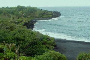 67 Waianapanapa State Park- turn off of the
Hana Highway at the sign for Waianapanapa and proceed towards the ocean
to the park. Bear left at the manager's residence and the campground will
be on your right (remember you need to get your permit prior to arriving
here in case someone asks to see it). Waianapanapa has a beautiful black
sand beach and a series of caves. It gets a lot of day use but things quiet
down in the evening and it makes a very nice place to stay. There are also
twelve cabins here that can be rented for about $50 a night. The trick is
to make your reservations about one year in advance of your intended stay.
The reservations are made through the office you use to obtain your camping
permit. We've stayed in them and I find them adequate- my wife draws the
line at two nights. They have kitchen facilities (including frig), hot showers,
flush toilets, and room for six. A group of bicycle tourists would find
them very comfortable as compared to tent camping. There is some very beautiful
hiking along the rocky coastline in this area. There is in fact an old Hawaiian
trail that leads back into Hana from here. It is easy to spend several days
in the Hana area and Waianapanapa is a reasonable place to stay.
67 Waianapanapa State Park- turn off of the
Hana Highway at the sign for Waianapanapa and proceed towards the ocean
to the park. Bear left at the manager's residence and the campground will
be on your right (remember you need to get your permit prior to arriving
here in case someone asks to see it). Waianapanapa has a beautiful black
sand beach and a series of caves. It gets a lot of day use but things quiet
down in the evening and it makes a very nice place to stay. There are also
twelve cabins here that can be rented for about $50 a night. The trick is
to make your reservations about one year in advance of your intended stay.
The reservations are made through the office you use to obtain your camping
permit. We've stayed in them and I find them adequate- my wife draws the
line at two nights. They have kitchen facilities (including frig), hot showers,
flush toilets, and room for six. A group of bicycle tourists would find
them very comfortable as compared to tent camping. There is some very beautiful
hiking along the rocky coastline in this area. There is in fact an old Hawaiian
trail that leads back into Hana from here. It is easy to spend several days
in the Hana area and Waianapanapa is a reasonable place to stay.
I stayed with some friends and spent a day working with them on a house they are constructing before riding back to Kahului the following day. I didn't get a particularly early start, but after waiting and realizing the morning was going to serve up showers I headed up the Hana Highway.
74 It has been a steady climb from Waianapanapa to the turn off for Nahiku. It would be a swift 2 1/2 mile run down this hard surface road to the ocean and a difficult 1000 foot climb back out although the view up the coastline is beautiful. There are a number of residences along the road and no stores or services.
There are in fact no stores or services along the Hana Highway between Hana and Haiku a distance of about 40 miles. There are a couple of small scale commercial enterprises in Keanae (mile 82) selling softdrinks, hotdogs, and snacks. As was described earlier the road is narrow with many one lane bridges (56) and lots of curves. This stretch is very lush due to lots of rainfall. This morning is very overcast and showers are numerous. It is warm and the rain isn't uncomfortable. It's a beautiful ride.
76.5 Puaa Kaa Park is a state roadside park with restrooms and water. Later in the morning it will have a parking lot full of rental cars, but at 9:00 I have it to myself. From Hana to here has been an 1100 foot climb with only occasional glimpses of the ocean.
78 After leveling off at Puaa Kaa the road begins its descent. There is a turn out that gives you a beautiful overlook of the village of Wailua. Those water filled gardens are taro patches. The taro root is used to make the Hawaiian food staple poi.
81 The turnoff to ride out to Wailua is a sharp right turn here. You have made a descent of about 1000 feet in the last 3 miles of highway. A new experience for me through this stretch was zipping through a sharp curve and dragging the bottom of a front pannier on the roadsurface. I hadn't used Lowrider racks before-my Sequoia front rack carries the panniers rather high.
82 First chance for cold drinks and snacks since leaving Hana. You are nearing the Keanae Peninsula.
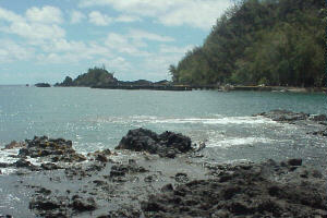
 82.5 The Keanae Peninsula was formed when lava
flowed out of the Koolau Gap in Haleakala and made its way to the ocean.
As in Wailua they grow a lot of taro here. Taking the turnoff here will
put you beside the ocean once again. Wonderful views up and down the coast,
waves crashing on a shoreline of lava formations. Don't pass up Keanae.
You will probably find a fruit vendor or two set up on the peninsula.
82.5 The Keanae Peninsula was formed when lava
flowed out of the Koolau Gap in Haleakala and made its way to the ocean.
As in Wailua they grow a lot of taro here. Taking the turnoff here will
put you beside the ocean once again. Wonderful views up and down the coast,
waves crashing on a shoreline of lava formations. Don't pass up Keanae.
You will probably find a fruit vendor or two set up on the peninsula.
83 Back out on the highway at the first bend in the road will be Keanae Aboritum. A hardsurface walkway through tropical vegatation, nicely maintained and it's free.
83.5 Keanae YMCA- I had heard that camping was available at this location but didn't have any first hand knowledge so I decided to check it out. I found the caretaker and he told me that indeed camping was available as well as cabin accommodations. Resevations have to be made in advance with the Y in Kahului. The cost for tent camping or staying in one of the cabins is the same- $10/person/night. They have an 8 person cabin and a 14 person cabin . I forgot to ask if there was a minimum number of people required for the cabins.
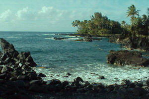
 85 There is an overlook that is easily missed
here. Because there isn't really a turnout for cars you might miss this
great view of Honomanu Bay. There are several rough benches set off the
roadway and walking past them will bring the bay into view 400 feet below.
This coastline has very few bays of any size and none that are accessable
by road other than Hanamanu. You can camp here and in fact it gets some
heavy use by locals on the weekends. From the overlook you can view the
road ahead across the bay as it climbs up the cliff face. To gain access
to the beach take the first turnoff at milepost 14. Taking the second turnoff
further on puts you on the other side of a fresh water stream that flows
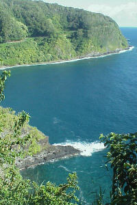
into the bay making beach access more difficult. As you make your way down
the roadway from the overlook you will notice that portions of the highway
are slipping into the ocean below, rendering the road to one lane in places.
This is evident in several other stretches as well. The Hana Highway has
never been what could be described as a "good" road. It wasn't
even paved all the way to Hana until 1970. The worst thing that happened
to the highway was when Federal regulations were brought to bear upon it.
Seems the Feds were upset by the lack of signage describing the road conditions,
but even more concerned about the lack of guard rails along the narrow,
twisting, sheer dropoff edges of the highway. To bring it into compliance
required drilling a series of 10 inch holes 4 feet apart along the edge
of the cliff and installing steel I beams to which they bolted steel guard
rail. These closely spaced holes provide a perfect place for nature to "tear
along the dotted line". It is not unusual to see
85 There is an overlook that is easily missed
here. Because there isn't really a turnout for cars you might miss this
great view of Honomanu Bay. There are several rough benches set off the
roadway and walking past them will bring the bay into view 400 feet below.
This coastline has very few bays of any size and none that are accessable
by road other than Hanamanu. You can camp here and in fact it gets some
heavy use by locals on the weekends. From the overlook you can view the
road ahead across the bay as it climbs up the cliff face. To gain access
to the beach take the first turnoff at milepost 14. Taking the second turnoff
further on puts you on the other side of a fresh water stream that flows
into the bay making beach access more difficult. As you make your way down
the roadway from the overlook you will notice that portions of the highway
are slipping into the ocean below, rendering the road to one lane in places.
This is evident in several other stretches as well. The Hana Highway has
never been what could be described as a "good" road. It wasn't
even paved all the way to Hana until 1970. The worst thing that happened
to the highway was when Federal regulations were brought to bear upon it.
Seems the Feds were upset by the lack of signage describing the road conditions,
but even more concerned about the lack of guard rails along the narrow,
twisting, sheer dropoff edges of the highway. To bring it into compliance
required drilling a series of 10 inch holes 4 feet apart along the edge
of the cliff and installing steel I beams to which they bolted steel guard
rail. These closely spaced holes provide a perfect place for nature to "tear
along the dotted line". It is not unusual to see 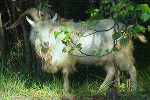 portions of the
guard rail hanging in the air after the surrounding cliff face has fallen
away. The real condition of the road is more visible from a bicycle than
from a motorized vehicle. The bridges are in remarkably good condition considering
the majority of them were constructed around 1910. They are some of the
early forms of steel reinforced concrete bridges. I noticed that several
of them had been built over falls in the streambeds they cross; looking
over one side of the bridge will show a stream 10 feet below the roadbed
while looking over the other side will reveal a pool almost 100 feet below.
portions of the
guard rail hanging in the air after the surrounding cliff face has fallen
away. The real condition of the road is more visible from a bicycle than
from a motorized vehicle. The bridges are in remarkably good condition considering
the majority of them were constructed around 1910. They are some of the
early forms of steel reinforced concrete bridges. I noticed that several
of them had been built over falls in the streambeds they cross; looking
over one side of the bridge will show a stream 10 feet below the roadbed
while looking over the other side will reveal a pool almost 100 feet below.
 87.5 Kaumahina State Wayside- Restrooms
and associated running water. Reaching this wayside later in the morning
means the traffic is getting heavier and usage increases. Walking up the
incline at the end of the parking lot reveals picnic tables and a spectacular
view down the coast to the Keanae Peninsula.
87.5 Kaumahina State Wayside- Restrooms
and associated running water. Reaching this wayside later in the morning
means the traffic is getting heavier and usage increases. Walking up the
incline at the end of the parking lot reveals picnic tables and a spectacular
view down the coast to the Keanae Peninsula.
92 You will notice that the vegetation is changing from the lush tropical variety to more of a temperate variety. As the average annual rainfall changes so will the flora.
96 You have been riding without a bike lane for about 70 miles, but that changes now. In fact the beautiful, twisting, climbing, descending road loses all of its charactor. The bike lane is new within the last 3 years. The traffic here increases its speed and having a bike lane to retreat to is welcome. It has a lot of stones/pebbles/cinders on its surface so riding exclusively in the bike lane isn't recommended.
102 A store/deli on the left side of the road will provide cold drinks and sandwiches.
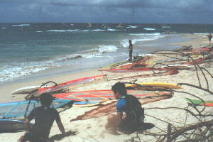 106 Hookipa Beach Park- After passing through
the pineapple fields you will once again be nearing the ocean and should
stop at Hookipa. If the conditions are right you will see some worldclass
windsurfing. A lot of Europeans come here for the great combination of surf
and wind.
106 Hookipa Beach Park- After passing through
the pineapple fields you will once again be nearing the ocean and should
stop at Hookipa. If the conditions are right you will see some worldclass
windsurfing. A lot of Europeans come here for the great combination of surf
and wind.
109 Paia- first town since Hana. A hippie haven in the 70's with a few hanger-ons today. Postoffice, stores, restaurants, gas stations, galleries, giftshops, etc.
110 Baldwin Beach Park- A good place to stop and clean up (outdoor freshwater showers) and prepare to leave the island if that is what you must do at this point. The last decent place to hang out before the airport if you have some time to kill.
112 This unmarked one way road is the best way to make your way back to the airport. The main terminal is on the other side of the runway, so proceed beyond the heliport on this side of the runway and peddle along the main runway until you can cross to the other side turn right and make your way to the terminal.
115 Kahului Airport