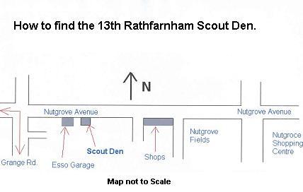
Alternatively, the 16, 15, 15A, 15C, 14 and 48 (A) all stop near the Nutgrove Avenue.
A map of the area (with buslines on it) can be obtained from the Ordnance Survey (http://www.osi.ie/)
Rathfarnham is on the southside of Dublin.
Rathfarnham (Irish: Rath Fearnain), on Dublin's Southside is home to Rathfarnham Castle, Loreto Abbey, Marlay Park, the Sarah Curran and the landmark Yellow House pubs. Padraig Pearse set up and ran St Enda's School for Boys in Rathfarnham, which is now a museum in his honour situated in St Enda's Park.
Rathfarnham is located at 53� 18′ 2″ N 6� 16′ 58″ W (http://kvaleberg.com/extensions/mapsources/index.php?params=53_18_2_N_6_16_58_W_).
Rthfarnham is easily reached via the M50A. According to the Irish Central Statistics Office (http://www.cso.ie/census.html), the town has a total area of around 4.02 square kilometres. According to the 2002 census, the population of Rathfarnham is 17,717, a decrease of 2.78% (493 people) since the 1996 census.