Below are links with which you can find out anything about the weather, from what it's going to be like today, to actually tracking a storm that is exhibiting strong rotation on the National Weather Service Doppler Radar.
February 16, 2006 TORNADO WARNING
Click Here For New Christmas Animation
![]()


National Weather Service Warning Decision Simulator
Storm Prediction Center Hourly Mesoscale Analysis
GOES-E Conus Infared Weather Satellite Imagery
National Centers For Environmental Prediction
Tomorrows National Severe Weather Forecast
Weather Underground Nexrad Doppler Radar
Current National Severe Weather Forecast
National Severe Storm Laboratory (NSSL)
Live Doppler Radar of Illinois and Indiana
National Weather Service Doppler Radar
Automated Surface Observing System
WxChat.com's Virtual Storm Chase
World Meteorological Organization
Storm Spotter Guides BY SkyWarn
Live Doppler Radar of the Midwest
American Meteorological Society
National Severe Weather Alerts
Live Doppler Radar of the U.S.
Local Severe Weather Alerts
Hazardous Weather Outlook
Cloud Chart by Weatherbuff
Current Hammond Weather
National Data Buoy Center
Midwest Lightning Strikes
Fox Live Power Doppler
Current Wind Chill Map
Current Wind Currents
Enhanced Fujita Scale
Illinois Storm Chasers
Nexrad Doppler Radar
Current Snow Depths
Current U.V. Forecast
The Green Sky Effect
Current Jet Stream
Current Heat Index
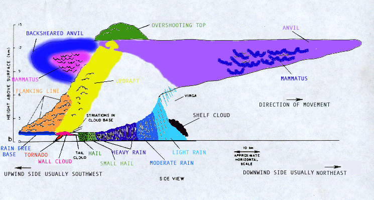
Supercell Diagram
Weather Pictures
Live Doppler 5
NOAA Chicago
Accuweather
SkyWarn
You are number
� 2009 [email protected]