ARCHAEOLOGICAL DISCOVERIES
BUNDORAN-BALLYSHANNON BYPASS
ACKNOWLEDGEMENTS
This report was compiled by Donegal NRRDO archaeologists based partly on information derived from Post-Excavation Assessment Reports and from field observation during the course of the excavations. Thanks to IAC Ltd and it’s directors who worked on the scheme and who compiled the assessment reports (S.Delaney, F.Walsh, B.O’Donoghue -special thanks for historical context of Ballyhanna church-and others)
The full 18 page report can be found at this website CLICK HERE . It a 2 Mb PDF File
Below is a short extract. Be sure to download the full Report
INTRODUCTION
In the summer of 2003 a programme of archaeological works connected with the construction of the N15 Bundoran-Ballyshannon commenced with test excavations along the entire 10.5km length of the route. These test excavations were targeted at a number of potential archaeological features that had been identified in 2001 from desktop research and field walkovers connected with the EIS. About 22,200 linear metres of additional test trenches were also dug along the entire length of the development, the purpose being to identify any other archaeological features or complexes of which there was no trace visible above ground (Figure 1).
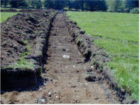 Fig 1: archaeological test trenching along the route of the N15 Bundoran-Ballyshannon Bypass
SUMMARY OF ARCHAEOLOGICAL DISCOVERIES
A number of archaeological discoveries were made along the route, dating from the Neolithic (4000BC-2500BC) up to the more recent post-medieval period (post 1700 AD). Representing settlement and ritual activity dating to some of the earliest periods of human settlement in Ireland, the exciting discoveries ranged from one of the frequently found fulachta fiadh, or burnt mounds, dating predominantly from the Bronze Age, to a possible brushwood trackway perhaps dating to an even earlier Neolithic period, from a probable Iron Age linear earthwork, to the discovery of a forgotten medieval cemetery and church, as well as a number of other sites from varying periods.®
Townland Archaeological Discoveries
Ballyhanna Medieval church & cemetery
Sminver See Full Report . . Click here
Ballynacarrick See Full Report . . Click here
Rathmore and Finner See Full Report . . Click here
Magheracar See Full Report . . Click here
Table 1
List of archaeological sites excavated along the route of the N15 Bundoran-Ballyshannon Bypass
BALLYHANNA MEDIEVAL CHURCH & CEMETERY
The discovery of human skeletal remains in a green field on the outskirts of Ballyshannon during the 2003 test excavations made it immediately clear that this was an area of formal burial. The subsequent 7 month excavation that took place on the site in Ballyhanna townland revealed the exciting discovery of the foundations of a medieval church building and associated cemetery on the S bank of the River Erne. Thought to date from between 1 100AD-1400AD the presence of a church and graveyard in this location was not known before its discovery by the bypass archaeological works.
The Church
Measuring about 14m x 7m the low foundations of a building were uncovered in early 2004 along the edge of the East Port road. While the northern wall of the building had been removed through later road building the other sides of the structure were clear. Since the burials respected the foundations (a number of burials were placed with their heads resting directly against the wall foundation), it was clear that the building had already been standing when the burials were placed in the ground. That, along with the E-W orientation of the structure suggested it was the remains of a church building. Test excavations within the interior of the church revealed a clay floor surface beneath the rubble collapse of the wall. A handle of a shallow bowl was uncovered from the foundation trench of the S wall, decorated with a crude cross-perhaps belonging to a vessel used in the Eucharist?
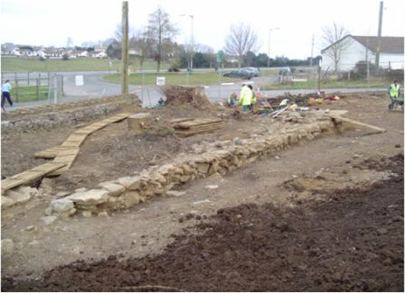 Fig 2: Foundations of Ballyhanna Medieval Church
Following discovery of the church Donegal County council was able to reconfigure the junction layout in this area, keeping within the lands purchased for the construction of the bypass. With the junction redesigned the church foundations and an area around it have been preserved in situ. With funding made available by the National Roads Authority, Donegal County Council is working with the Department of Environment, Heritage & Local Government and interested local groups and schools to present the church as a small heritage park able to be enjoyed by the people of Ballyshannon and the visitors to the town.
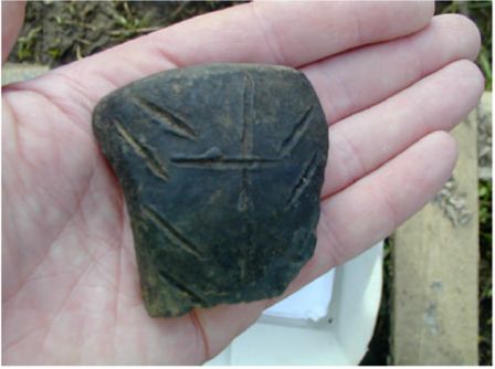 Fig 3 : Cross decorated medieval bowl handle from church at Ballyhanna
The Cemetery
To the E, S and W of the church building, within a relatively small area, the skeletal remains of approximately 1200 human individuals were excavated. Ranging in degrees of intactness, the bones were well preserved due to the nature of the soil conditions in this area, though many of the burials had suffered disturbance caused by the digging of later burials. Men, women and children were present within the skeletal assemblage, signifying that this was a communal graveyard for use by all members of society and not just clergymen. Principle dating evidence for the burials came from a number of coins found associated with some of the burials, notably, three silver long cross pennies and halfpennies dating from the reign of Henry III (1251AD-1276AD) and Edward I (c.1280AD-1302AD) while other artefacts found within the graves included a number of bone beads belonging to pieces of jewellery, shroud pins used to help wrap the dead, and many pieces of quartz, found often placed in the hands of the burials. The significance of the quartz is not certain, but clearly from its high levels of occurrence, the placing of quartz in the hands was a widespread burial rite at this time, in the medieval period, in Ballyshannon.
Most of the burials were placed in the traditional Christian manner on their back and laid out prone E-W, with the head at the W. Some, however were not, evoking the burial rites of earlier pre-Christian times, crouched in foetal-like positions.
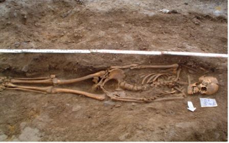 Fig 4: Ballyhanna (SK545) typical E-W extended inhumation . . . .Photo: IAC Ltd.
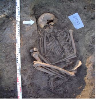 Fig 5 : Ballyhanna (SK543) crouched Inhumation . . Photo: IAC Ltd.
Just E of the church at the lowest level of the graveyard, on undisturbed natural soil, a stone-lined hearth-like pit was discovered- perhaps to light the Pascal fire. Another cist-like, stone lined “box” found S of the church contained a quantity of quartz pebbles, the remains of a medieval shrine, the quartz being votive deposits.
The Skeletal Remains
The potential of the Ballyhanna skeletal assemblage in being able to throw light on medieval Ballyshannon cannot be overstated. The post-excavation process involving the bones will start with the careful cleaning of the assemblage, overseen by a qualified osteoarchaeologist, a specialist in analysing skeletal material. The second phase of post-excavation works will comprise an analysis of the material itself. This comprehensive study will yield data on the age at time of death of each of the burials, the sex of each, and will examine the skeletons for any signs of pathology, illnesses that may have displayed themselves in the skeletons, ranging from everyday caries, or tooth decay to common ailments such or arthritis to rarer more historical illnesses caused by dietary deficiencies such as rickets. Traumatic episodes are often also visible on bones and can tell us much about how the people lived and often how they died. Broken and healed bones can tell us of everyday mishaps, while healed sword marks, for instance indicate turbulent times. Such an example is known from the Ballyhanna burial ground where one unfortunate gentleman was found with an iron projectile, probably an arrowhead, embedded deep in one of his vertebrae, which led most likely to his death.
The collection of Ballyhanna skeletal material, clearly representing a large portion of the population of medieval Ballyshannon will yield much information on the diet of the times, the lifestyle and also on mortality rates and frequency of illnesses and disease. Such a detailed osteoarchaeological analysis takes time and full information will not be known for some time yet, but it is hoped that the study will provide much understanding of life, and death, in an Irish medieval town.
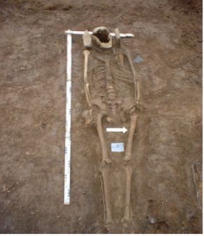 Fig 6: Ballyhanna (SK1239) with “Ear Muff” stones . .
Ballyhanna Church- the historical context
By the 6th century the northern Ui Neill dominated the whole of the Donegal. The rivalry between the O'Neills and the O’Donnells had its origins in the medieval period and power struggles between Cenel Conaill and Cenel Eogain. The area between the Rivers Drowes and the Erne was controlled by Cenel Conaill and was known as Magh Eine (Simms 1995, 187). By the 1100’s, new Gaelic families came to power throughout Ireland, and few grew as powerful or renowned as the O’Donnell’s of Tir Conaill, and the O’Connor’s of Connacht. A power struggle instantly developed between these families, and the plain of Maigh Eine, between the Erne and the Drowes became their battleground. Sometime around 1180, O’Donnell, in a move designed to safeguard the western route into Ulster, invited the Cistercian monastery in Boyle to establish a daughter house on lands that he would donate to them (It must be remembered that the first castle built by the O’Donnell Clan to serve this purpose was not constructed until the mid-1400’s). And so, the abbey of Assaroe came to be built on the N side of the Erne River, and the monks were given an estate of 16,000 acres both north and south of the Erne. It was no coincidence that this land was located in such a turbulent political border area as it was a common tactic at the time to place a church and church lands along a kingdom’s border. Serving as notification that you were now entering the lands of someone wealthy and powerful enough to support a monastery, warriors would also have been slow to fight or shed blood on holy land- ecclesiastical lands on borders offered certain protection. To maintain a 16,000-acre estate, communities of lay people were taken on as tenants farming the land for the Cistercians, who would in turn administer to the tenants spiritual needs. These tenants however could not attend mass in the Abbey church, or be buried in the cemetery; the Cistercians reserving this right for the monks alone. Instead, small Chapels of Ease were built and it was in these satellite churches the tenants would come to receive the sacraments, or to be buried.
Around 1250, two new political entities appeared on the scene. After the Synod of Rathbrassil, the Church established diocesan boundaries for the first time, in an attempt to move power away from the monastic settlements, and towards a more centralised and unified church. This saw the establishment of the Diocese of Clogher and Raphoe. Under canon law, each diocese was entitled to access to the sea, to enable each to have direct communication with Rome. As the Diocese of Clogher was focused around Fermanagh, South Armagh and Louth it had no access to the sea. To solve this, it was granted land that stretched out from the diocesan heartland in Fermanagh, along the Erne to Ballyshannon and the Atlantic. These borders have remained practically unchanged right up to the present day.
By 1250 then, there were two religious powers active in Ballyshannon, both capable of building and maintaining a church and cemetery in the townland of Ballyhanna: the Cistercians at Assaroe, and the Diocese of Clogher. Interestingly, the Irish for Ballyhanna is Baile na Mainigh, or “the Town of the Monks”, even more curiously, in old Irish, Mainigh was a word used to describe tenant farmers on monastic estates. Could it be then, that the church and cemetery in Ballyhanna is a Chapel of Ease built by the Cistercians to cater to the spiritual needs of their tenants? The only problem with this theory is the fact that the townland of Ballyhanna was the only townland on the southern bank of the Erne not actually given to the monks by O’Donnell and it remained the property of the Diocese of Clogher, and served as their access to the sea. So was this church, located, as it is right on the site of the ford across the Erne, on the border between O’Donnell and O’Connor, Connacht and Ulster, Raphoe and Clogher, built by the diocese of Clogher designed to act as a border marker between all these great powers?
It is anticipated that further research and post-excavation works may shed further light on the date and historical context of the church.
Click here to see the full report