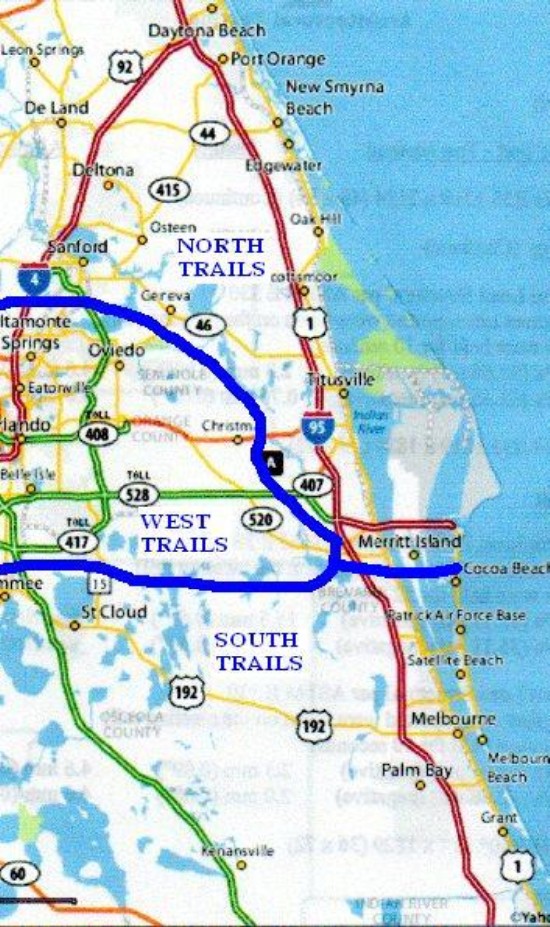
North trails are those North of Hwy 520 in Brevard County, Florida. Most Hikes to the North meet at the Lowe's parking lot on Hwy 50 in Titusville near I-95. at 8:30 AM. Four of these trails; Ulumay, Viera Wetlands, Moccasin Island, and Cruickshank Sanctuary, will still meet at McDonalds at I-95 and Hwy 520 in Cocoa at 8:30 AM. Click on schedule link for our next Wednesday Hike destination or on the trail name for more information on that trail.
DIRECTIONS TO BULOW CREEK TRAIL
From Lowe's Parking lot at Hwy 50 and I-95, take I-95 north to the Old Dixie Highway Exit (exit 278, one exit past the US-1 exit.) Take Old Dixie Highway south (right) about two miles to Bulow Creek State Park / Fairchild Oaks parking lot. We park there but take a few cars to the trail end at the Bulow Plantation Ruins State Historic Site to use to shuttle back to the starting point at Fairchild Oaks. To get to the Historic site, backtrack on Old Dixie Highway to the intersection with Hwy 2001. Turn right on 2001 and drive about two miles to the Historic site entrance road, the trail crossing is about a mile down the road on the right. The trail is about seven miles long one way. Scenery is worth whatever it takes to get there.
for more info, goto http://funandsun.com/parks/BulowCreek/bulowcreek.html
GPS for meetingplace is N28 33.294' W80 50.958', for the trailhead is N29 23.289' W81 7.879'
DIRECTIONS TO ST. FRANCIS TRAIL
From Lowe's Parking lot at Hwy 50 and I-95 take I-95 north to the Deland/New Smyrna Beach exit (Hwy 44.) Take Hwy 44 west through the town of Deland to the St. Johns River. Immediately after crossing the river, take Hwy 42 north a few hundred feet to the road marked River Forest Group Campground. Turn right on that road, proceed another few feet to a road marked "St. Francis Trail parking." Follow arrow to parking lot. The trail is about three miles to the St. Johns River on one leg and four miles on the other. We can do the complete trip of seven miles or return on the three mile leg for a six mile hike. Trail is of flagship quality, good wildlife, wildflowers, birds etc.
for more info, goto http://www.outintheboonies.com/st_francis
GPS for meetingplace is N28 33.294' W80 50.958', for the trailhead is N29 0.748' W81 23.511'
DIRECTIONS TO BLUE SPRINGS TRAIL
From Lowe's Parking lot at Hwy 50 and I-95, take I-95 north to the hwy 46 exit. Take hwy 46 to Sanford, turn right on hwy 17 - 92 in downtown Sanford. Proceed north on 17 - 92 to the town of Orange City (about twelve miles.) Turn left at the Blue Springs State Park sign in Orange City and drive about three miles to the park. Park at the end of the road in the parking area. The trail is on the left (south) and is about three and a half miles to the river, you return on the same trail for a total of seven miles. Scenery is great but trail can be sandy and there is a wet area which can shorten the trail a by a mile or so.
for more info, goto http://funandsun.com/parks/Bluespring/Bluespring.html
GPS for meetingplace is N28 33.294' W80 50.958', for the trailhead is N28 56.548' W81 20.437'
DIRECTIONS TO THE PINE ISLAND TRAIL
From Lowe's Parking lot at hwy 50 and I-95, take 50 East a short distance to the Hwy 405 intersection. Take 405 East to the Kennedy Space Center bypass and take the bypass to State Road 3. (Courtney Parkway.) Take SR 3 South about two miles to Pine Island Road (look for the sign on the right side of SR 3, the road on the left side has another name, Judson Road) Take Pine Island Road about three miles to the Pine Island Conservation Area entrance. Park just inside the gate and the trail starts down the road toward the Power Plant. Total distance is about four miles. Great birding and wildflowering.
for more info, goto http://pica.eelbrevard.com/
GPS for meetingplace is N28 33.294' W80 50.958', for the trailhead is N28 29.549' W80 43.301'
DIRECTIONS TO THE ENCHANTED FOREST TRAILS
From Lowe's Parking lot at Hwy 50 and I-95, take 50 East a short distance to the Hwy 405 intersection. Take 405 East about two miles to the Enchanted Forest entrance on the left. Drive to the hike desk and obtain a trail map. There are several trails available all worth whatever it takes.
for more info, goto http://www.nbbd.com/godo/ef/index.html
GPS for meetingplace is N28 33.294' W80 50.958', for the trailhead is N29 31.972' W80 45.150'
DIRECTIONS TO LAKE PROCTOR WILDERNESS TRAIL
From Lowe's Parking lot at hwy 50 and I-95, take I-95 north to The Sanford / Mims exit. (Hwy 46) Take hwy 46 west about fifteen miles to the Lake Proctor Trail entrance. (look for sign on right after passing large power lines crossing highway). There are several variations to the trail, get a map at the kiosk. Several ecosystems are represented.
for more info, goto http://www.outintheboonies.com/lake_procto
GPS for meetingplace is N28 33.294' W80 50.958', for the trailhead is N28 43.585' W81 5.938'
DIRECTIONS TO THE FLAGLER TRAIL
From Lowe's Parking lot at hwy 50 and I-95, take I-95 north to The Sanford / Mims exit. (Hwy 46) Take hwy 46 west about seventeen miles to the town of Geneva. Turn right at First Street (at traffic light, the continuation of First Street South is Snowhill Road) Take First a few blocks to Avenue C. Turn left on Avenue C and proceed a couple blocks to Old Geneva Road. Turn right on Old Geneva and follow it to Osceola Road in about a mile. Turn right on Osceola Road (marked East Osceola Road) for about six miles to Fish Camp Road. The trailhead is a few feet into Fish Camp Road, look for parking lot and "King Phillipstown" historical marker. The trail leaves the parking lot along Fish Camp Road and follows Osceola Road for several miles until it terminates in the town of Geneva. There is no parking on that end so all hiking must be from the Fish Camp Road parking lot.
for more info, goto http://www.visitseminole.com/pw/trails/trails_flagler.asp
GPS for meetingplace is N28 33.294' W80 50.958', for the trailhead is N28 47.276' W81 4.099'
DIRECTIONS TO CANAVERAL MARSHES TRAIL
From Lowe's Parking lot at hwy 50 and I-95, go west on 50 about three miles to a road on the South (left) side of the highway with a white Canaveral Marshes Conservation Area sign. There is a gate about 100 yds in with a kiosk, the trail terminus is on the left. The trail is about two miles along a dike to the Addison Canal, about a mile along the canal, and a four mile loop through a wooded area.
for more info, goto http://www.outintheboonies.com/canaveral_marshes
GPS for meetingplace is N28 33.294' W80 50.958', for the trailhead is N28 32.664' W80 53.791'
DIRECTIONS TO THE MERRITT ISLAND WILDLIFE PRESERVE TRAILS
From Lowe's Parking lot at Hwy 50 and I-95, take I-95 North to the hwy 406 exit (Garden St.) at Titusville. Take 406 East past hwy US 1 and across the Indian River. About two miles past the Coast Guard Station just across the Indian River Bridge, the road separates. Take the right fork (hwy 402) about three miles to the Oak Hammock Trail on the North side of the road. (You pass a visitors center just before the trailhead, stop in for more information.) Go back to the intersection of hwys 406 and 402 and take 406 for about a mile and turn on the Black Point Wildlife Drive. About a mile later, at stop 4, find the Wild Birds Unlimited Trail. In another two miles, find the parking lot for the Cruickshank Trail. Again, from the intersection of hwys 406 and 402, take 406 about six miles to State Road 3. Turn left on SR 3 and drive about a mile and a half. Look for a sign saying "public access" on the left side of the road next to a dirt road. If you get to a building marked "Bio Lab" on the right side of the road, you have gone too far. There is a small parking lot inside leading to an unnamed dike trail. Just before the building on the right side of the road is another trail named the Scrub Ridge Trail. The last one is several miles further, North of Haulover Canal. Look for a Pine Flatwoods Trail sign. The Cruickshank Trail is five miles long as is the unnamed dike trail. The others are about half a mile to two miles each. See also the Shiloh Marsh Trail below. World class birding on all of them.
for more info, goto http://www.nbbd.com/godo/minwr/index.html
GPS for meetingplace is N28 33.294' W80 50.958', for the trailhead is N28 38.510' W80 44.158'
DIRECTIONS TO THE SHILOH MARSH TRAIL
From Lowe's Parking lot at Hwy 50 and I-95, take I-95 North to the Hwy 5-A exit. Take 5-A to US Hwy 1 and turn left (north) and drive about 4.5 miles to SR-3 (Kennedy Boundary Parkway). Turn right on SR-3 about 4.1 miles to Shiloh 3 road on the right. There are several parking areas along Shiloh 3 Rd. to choose. Park and hike to a gate at the intersection with Shiloh Marsh Road. Turn left on Shiloh Marsh Road and hike to the next intersection. Take the intersecting road (Weathertower Road), In about a mile, you hit SR-3 again. Look for Weathertower Road sign, hike SR-3 north (left turn) back to Shiloh 3 Road to complete 4.25 mile hike.
for more info, goto http://www.nbbd.com/godo/minwr/index.html
GPS for meetingplace is N28 33.294' W80 50.958', for the trailhead is N28 47.344' W80 48.223'
DIRECTIONS TO BLUE HERON WETLANDS PARK
From Lowe's Parking lot at hwy 50 and I-95, drive about half a mile West on 50 to the Blue Heron Water Treatment Plant, turn in and after a short drive stop at the first building and sign in. Proceed to the end of the road. The trail is on the dike and is a couple of miles long.
for more info, goto http://www.cfbw.com/blueheron.shtml
GPS for meetingplace is N28 33.294' W80 50.958', for the trailhead is N28 32.596' W80 51.608'
DIRECTIONS TO THE DORIS LEEPER SPRUCE CREEK BLUFFS TRAIL
From Lowe's Parking lot at Hwy 50 and I-95, take I-95 North to the New Smyrna Beach/ Deland exit (Hwy 44). Take Hwy 44 East about half a mile to Sugar Mill Drive. Turn left (North) on Sugar Mill and drive about a mile and a half to Pioneer Trail. Turn left (West) on Pioneer Trail or about a mile to Turnbull Bay Road. Take Turnbull a short way to Martins Dairy Road. Turn left on Martins Dairy and drive to end of road about a mile) The trailhead is on the West side of the parking lot where there is a large kiosk with trail maps and info. The main blue marked trail is six and a half miles around but there are many bailouts which can be used to shorten the loop. There are maps along the way at each intersection to guide you.
for more info, goto http://www.volusia.com/sprucecreek/
GPS for meetingplace is N28 33.294' W80 50.958', for the trailhead is N29 4.025' W81 0.087'
DIRECTIONS TO THE LAKE WOODRUFF WILDERNESS TRAILS
From Lowe's Parking lot at Hwy 50 and I-95, take I-95 North to the New Smyrna Beach/ Deland exit (Hwy 44). Take Hwy 44 West through Deland to Hwy 4053 (the street signs say Glenwood Road and Grand Av.). Turn right on Hwy 4053 and proceed about seven miles to the Lake Woodruff sign and turn left. The parking lot is across the railroad tracks at the end of the road. There are several miles of dikes surrounding ponds that are open for hiking. super birding and wildflowering.
for more info, goto http://www.fws.gov/lakewoodruff/
GPS for meetingplace is N28 33.294' W80 50.958', for the trailhead is N29 6.410' W81 22.262'
DIRECTIONS TO ULUMAY PRESERVE TRAIL
From McDonalds parking lot at Hwy 520 and I-95, take Hwy 520 East through Merritt Island to Sykes Creek Parkway across Hwy 520 from Merritt Square Mall. Take Sykes Creek Parkway North across the Sykes Creek Bridge, turn left almost immediately across the bridge into the Ulumay Preserve. Park by the first entrance into the preserve, the trail is along Sykes Creek heading North and is about 3.5 miles one way.
for more info, goto http://www.brevardparks.com/historic/hist_ulumay.php
GPS for meetingplace is N28 21.552' W80 47.855', for the trailhead is N28 22.256' W80 41.014'
DIRECTIONS TO BUCK LAKE TRAILS
From Lowe's Parking lot at Hwy 50 and I-95, take I-95 North to the Hwy 46 exit (Mims / Sanford exit). Take 46 West about one mile to the Buck Lake Conservation Area entrance. Drive North a few hundred feet to the parking lot by the gate. The trail starts on the entrance road and shortly crosses a canal. Across the canal, there is a yellow blazed trail which is 1.2 miles long. A white blazed trail continues on the road making an 8.4 mile loop. There is a red blazed trail starting at the West Entrance which is about five miles west on Hwy 46 from the East entrance. It forms an 8.6 mile loop. The red and white trails intersect to form a 7.6 mile one way hike from the East to West trailheads.A third trail starts off of Hyw 46 about 10 miles from I-95. It is a half mile road trail ending at one of the St. John's river braids. The trailhead is just off of Hwy 46 on the East side of Morgan Alderman Road. The trails are all on roads but cover a variety of habitats.
for more info, goto http://www.outintheboonies.com/buck_lake/
GPS for meetingplace is N28 33.294' W80 50.958', for the trailhead is N28 40.234' W80 53.423' OR N28 40.329' W80 58.311'
DIRECTIONS TO KRATZERT CONSERVATION AREA TRAILS
From Lowe's Parking lot at Hwy 50 and I-95, take I-95 North to the Hwy 46 exit (Mims / Sanford exit). Take 46 West about twenty miles to Hwy 415 at Midway. Take Hwy 415 North across the St. Johns River Bridge. Turn left on Reed Ellis Road about a hundred yards and park in the Kratzert Conservation Area Parking lot. The trails consist of a two mile loop to the North and a short trail West to the river.
for more info, goto http://www.outintheboonies.com/kratzert/
GPS for meetingplace is N28 33.294' W80 50.958', for the trailhead is N28 49.913 W81 11.479'
DIRECTIONS TO LAKE MONROE / BRICKYARD SLOUGH AREA
From Lowe's Parking lot at Hwy 50 and I-95, take I-95 North to the Hwy 46 exit (Mims / Sanford exit). Take 46 West about twenty miles to Hwy 415 at Midway. Take Hwy 415 North across the St. Johns River Bridge about a half mile to the Lake Monroe / Brickyard Slough parking area. There are two trails on the property, a red blazed trail of about four and a half miles mostly through pasture but also a couple of oak hammocks and a walk along the St. Johns River marsh. The yellow blazed trail is about six miles through similar ecosystems. Both could be
wet in the rainy season. Good birding and wildflowers.
for more info, goto http://www.outintheboonies.com/lake_monroe/
GPS for meetingplace is N28 33.294' W80 50.958', for the trailhead is N28 49.207' W81 11.062'
DIRECTIONS TO ROCK SPRINGS RUN STATE RESERVE
From Lowe's Parking lot at Hwy 50 and I-95, take I-95 North to the Hwy 46 exit (Mims / Sanford exit). Take 46 West through Sanford and across the Wekiva River. About 2.5 miles past the river, turn left on Hwy 433. Drive in about a half mile to the entrance kiosk and obtain a trail map. There are several trails in the area ranging from short to very long. They are not well maintained so be careful.
for more info, goto http://www.outintheboonies.com/rock_springs_run/
GPS for meetingplace is N28 33.294' W80 50.958', for the trailhead is N28 48.526' W81 27.384'
DIRECTIONS TO THE VIERA WETLANDS TRAILS
From McDonalds Parking lot at Hwy 520 and I-95, Take I-95 South to the Viera exit (Hwy 509 or Wickham Road) drive in straight about two miles to the Waste Management buildings. The trails are a few hundred feet ahead on dikes around ponds. There are several routes to take varying from a mile or so to several miles. World class birding.
for more info, goto http://www.brevardcounty.us/environmental_management/VieraWetlands-Home.cfm
GPS for meetingplace is N28 21.552' W80 47.855', for the trailhead is N28 13.701' W80 45.598'
DIRECTIONS TO THE MOCCASIN ISLAND TRAIL
From McDonalds Parking lot at Hwy 520 and I-95, Take I-95 South to the Viera exit (Hwy 509 or Wickham Road) drive in straight about two miles toward the Waste Management buildings. Just before entering the Waste Management area, take the gravel road on the right, cross the canal, and turn left passing in front of the Duda office building. Continue another three or four miles until the road ends at the River Lakes Conservation Area. The trail runs along the dikes in both directions ending at a forested loop on the South leg and an observation platform on the North loop. The South loop is about seven miles and the North one about five.
for more info, goto http://www.sjrwmd.com/upperstjohnsriver/es/moccasinMRA.html
GPS for meetingplace is N28 21.552' W80 47.855', for the trailhead is N28 13.783' W80 48.665'
DIRECTIONS TO LAKE ASHBY TRAILS
From Lowe's Parking lot at Hwy 50 and I-95, take I-95 North to the Sanford exit (Hwy 46). Take Hwy 46 about twenty five miles to the Hwy 415 intersection. Take Hwy 415 north about fifteen miles to Lake Ashby road. Follow Lake Ashby road to Boy Scout Camp road and turn left. Follow Boy Scout Camp road to the Lake Ashby County Park entrance, turn right into the park. There are two trails, one is a two mile mostly boardwalk trail and the other is a short forest trail.
for more info, goto http://volusia.org/parks/ashbypark.htm
GPS for meetingplace is N28 33.294' W80 50.958', for the trailhead is N28 56.266' W81 5.014'
DIRECTIONS TO THE LAKE JESSUP TRAIL
From Lowe's Parking lot at Hwy 50 and I-95, take I-95 North to the Sanford exit (Hwy 46). Take Hwy 46 about thirty miles to Sanford Avenue in Sanford. Take Sanford Avenue South to Lake Jessup County Park. Be careful around Lake Mary Boulevard, its easy to get off track. The trail is a couple miles long and tends to be wet so don't bother in the wet season.
for more info, goto http://www.seminolecountyfl.gov/leisure/natland/jesup.asp
GPS for meetingplace is N28 33.294' W80 50.958', for the trailhead is N28 43.622' W81 15.843'
DIRECTIONS TO TURNBULL HAMMOCK \ SCOTTSMOOR LANDING
From Lowe's Parking lot at Hwy 50 and I-95, take I-95 North to the Hwy 5-A exit. Take 5-A to US Hwy 1 and turn right (South). Drive about a mile south to Huntington Ave. Take Huntington East all the way to the end and find Scottsmoor Landing park. The trail is on the gated dike immediately outside the park sign on the South side of the road. It loops to the West before returning at another gate a few hundred feet further West on the road. It is about two miles long all on dikes surrounded by brackish ponds. Great birding in the Fall.
GPS for meetingplace is N28 33.294' W80 50.958', for the trailhead is N28 46.239' W80 50.755'
DIRECTIONS TO THE KABBOORD SANCTUARY TRAIL
From Lowe's Parking lot at hwy 50 and I-95, take 50 East a short distance to the Hwy 405 intersection. Take 405 East to the Kennedy Space Center bypass and take the bypass to State Road 3. (Courtney Parkway.) Take SR 3 South about five miles to Hall Road. Take Hall Road East about a mile to a pump house and gate on the right (south) side of the road. The trail starts here and is on a semi-abandoned road which continues through varying stages of overgrowth to the barge canal. There turn left (east) about 2/3 of a mile to a more maintained road which will take you back to Hall Road, the parking area is about a third of a mile west. Total length is about five miles. Good wildflowers and birding in season.
GPS for meetingplace is N28 33.294' W80 50.958', for the trailhead is N28 26.055' W80 41.781'
DIRECTIONS TO THE DeLEON SPRINGS TRAIL
From Lowe's Parking lot at Hwy 50 and I-95 take I-95 north to the Deland/New Smyrna Beach exit (Hwy 44.) Take Hwy 44 about 17 miles to County Hwy 4101, take 4101 North (turn right) about three miles to Hwy 92, Take 92 West (turn left) about two miles to Hwy 17, take 17 North (turn right) about six miles to the town of DeLeon Springs. Most of the way through town, find a sign on the left side of the road directing you to the DeLeon Springs State Park. After paying the five dollar fee at the gate, drive into the park bearing right following the signs to the trail parking area. You will pass the trail on the way to the parking area on the right side of the road.
for more info, goto http://funandsun.com/parks/DeLeonSprings/deleon.html
GPS for meetingplace is N28 33.294' W80 50.958', for the trailhead is N29 7.926' W81 21.638'
DIRECTIONS TO SALT LAKE WMA TRAIL
From Lowe's parking lot at Hwy 50 and I-95, take I-95 North to the Hwy 46 exit North of Titusville. Take Hwy 46 West about half a mile to Turpentine Road, take Turpentine Road South about a mile and a half to Panther Road. Turn right on Panther Road and follow it around to Arch Road, at the end of Arch Road find the Salt Lake Wildlife Management Area. Get a map at the kiosk detailing the access areas. There are several miles of roads to hike. All of the trails are on roads but there is no vehicular traffic. This area can be very wet in rainy seasons.
for more info, goto http://www.sjrwmd.com/recreationguide/sc08/
GPS for meetingplace is N28 33.294' W80 50.958', for the trailhead is N28 38.397' W80 53.408'
DIRECTIONS TO THE FAY LAKE WILDERNESS AREA TRAIL
From Lowe's Parking lot at hwy 50 and I-95, take 50 East a short distance to the Hwy 405 intersection. Take 405 East to Grissom Blvd. Turn right on Grissom and drive about four miles to Fay Blvd. Turn left on Fay and drive to the very end which will be Fay Lake Wilderness Park. There is a 1.5 mile trail going clockwise around the property line starting fron the northwest corner of the lake and a somewhat shorter one going counter clockwise starting at the northeast corner of the lake. More trails are planned for the future.
GPS for meetingplace is N28 33.294' W80 50.958', for the trailhead is N28 27.706' W80 50.067'
DIRECTIONS TO THE CRUICKSHANK SANCTUARY TRAIL
From McDonalds parking lot at Hwy 520 and I-95, take I-95 South to exit 195 (Hwy 519), exit, loop over I-95, and turn right (East) on Barnes Blvd. Take Barnes east for 2.2 miles and the Sanctuary entrance is on the left. There is a kiosk with a trail map at the entrance. The trail is only about a one mile loop but it is a good place to observe scrub jays.
for more info, goto http://www.eelbrevard.com/eel/ep_recreation.php?pnl=1_7
GPS for meetingplace is N28 21.552' W80 47.855', for the trailhead is N28 17.635' W80 42.435'
DIRECTIONS TO SEMINOLE RANCH NORTH TRAILS
From Lowe's Parking lot at hwy 50 and I-95, take I-95 North to the Hwy 46 exit North of Titusville. Take Hwy 46 West about 4.5 miles to Hatbill Road (look for Loughman Lake Lodge sign) and take Hatbill Road South about three miles to a parking area on the left. There is a trail going East with an observation tower along a dike road. Continuing South on Hatbill Road another half mile or so there is another trailhead on the right side of the road leading to a trail again along dike roads. Both trails are excellent wildflower and birding trails but are open and will be wet during the rainy season.
for more info, goto http://www.outintheboonies.com/seminole_ranch
GPS for meetingplace is N28 33.294' W80 50.958', for the trailhead is N28 37.862' W80 56.843'
DIRECTIONS TO THE CHAIN OF LAKES TRAILS
From Lowe's parking lot at Hwy 50 and I-95, take I-95 North to Hwy 46 (Exit 223) and go east on W. Main Street (FL-46) 1.5 miles. Turn RIGHT onto US Hwy 1, go 1.5 miles then left on Jay Jay Road. The entrance to Chain of Lakes Recreation Area is on the right. There is a series of two or three miles of trail around the lake with an observation tower and several bridges. The trails are open and mostly paved.
GPS for meetingplace is N28 33.294' W80 50.958', for the trailhead is N28 38.677' W80 49.630'
DIRECTIONS TO THE CANAVERAL NATIONAL SEASHORE TRAILS
From Lowe's Parking lot at Hwy 50 and I-95 take I-95 north to the Deland/New Smyrna Beach exit (Hwy 44.) Take Hwy 44 about six miles East through New Smyrna Beach to Hwy A1A. Take A1A South about seven miles to the Canaveral National Seashore Ranger Station. Maps and information is available there.
for more info, goto http://www.nbbd.com/godo/cns/index.html
GPS for meetingplace is N28 33.294' W80 50.958', for the trailhead is N28 56.180' W80 49.754'
TURTLE MOUND TRAIL
About one mile past the park entrance, there is a parking area on the right for the Turtle Mound Trail, it is about a 0.3 mile boardwalk to the top of Turtle Mound, a 35 foot high Native American lookout mound.
CASTLE WINDY TRAIL
Across from parking area 3 is the Castle Windy Trail. It is about one mile long and accesses coastal scrub and a Native American midden.
ELDORA TRAIL
The ElDora Trail starts at parking area 8 and is about a half mile long ending at a restored house from the Pioneer village of ElDora. Tours of the house are available.
ELDORA HAMMOCK TRAIL
The ElDora Hammock Trail starts at parking area 9 and is a one mile loop through a coastal hammock.
All of the trails offer excellent wildlife and wildflower viewing.
DIRECTIONS TO THE NORTH BREVARD WALKING TRAIL
From Lowe's Parking lot at Hwy 50 and I-95 take I-95 north to the next exit (Hwy 406,) cross I-95 and turn right on Carpenter St. Take Carpenter a couple of miles to Dairy Road. Cross I-95 again and turn left on Holder Road. Immediately on the North-east corner there is a small parking area and a trailhead. The trail is a pleasant 0.3 mile wooded loop squeezed between a sub-division and I-95.
for more info, goto http://www.abouttitusville.com/outdoors/hiking/index.html
GPS for meetingplace is N28 33.294' W80 50.958', for the trailhead is N28 38.426' W80 51.393'
DIRECTIONS TO THE WUESTHOFF NATURE TRAIL
From Lowe's Parking lot at Hwy 50 and I-95, take 50 East a short distance to Barna Avenue, turn right on Barna and in a couple of blocks find the sign to the trail in the median. Turn on Wuesthoff St. and the park is at the end of the street. There is an exercise course and a short nature trail. Look for a boardwalk on the left side of the paved trail just past the turn.
for more info, goto http://www.abouttitusville.com/outdoors/hiking/index.html
GPS for meetingplace is N28 33.294' W80 50.958', for the trailhead is N28 33.349' W80 49.569'
DIRECTIONS TO RIVERBREEZE PARK TRAIL
From Lowe's Parking lot at Hwy 50 and I-95, take I-95 North to the Hwy 5-A exit. Take 5-A to US Hwy 1 and turn left (North) about 12 miles to H.H. Burch Road, look for the Riverbreeze Park sign on the right. Take H.H. Burch Road a mile or so to the park entrance on the left. The trail starts near the left end of the parking lot and is about a two mile loop around a small lake and through a wooded area and a garden.
for more info, goto http://volusia.org/parks/riverbreeze.htm
GPS for meetingplace is N28 33.294' W80 50.958', for the trailhead is N28 53.877' W80 51.150'
DIRECTIONS TO THE SEMINOLE REST TRAIL
From Lowe's Parking lot at Hwy 50 and I-95, take I-95 North to the Hwy 5-A exit. Take 5-A to US Hwy 1 and turn left (North) about 14 miles to the traffic light in Oak Hill. Turn right and drive about two miles to the Seminole Rest Historic Park on the right. There is a short trail looping around the Plantation home which has been recently restored.
for more info, goto http://www.nbbd.com/godo/cns/Brochures/SeminoleRest/index.html
GPS for meetingplace is N28 33.294' W80 50.958', for the trailhead is N28 52.154' W80 50.257'
DIRECTIONS TO LYONIA PRESERVE TRAILS
From Lowe's parking lot at Hwy 50 and I-95, take I-95 North to Hwy 46 (Exit 223) and go east on W. Main Street (FL-46) 23.7 miles to Hwy 415. Take 415 North 7.1 miles to Howland Blvd. in Osteen. Take Howland 6.6 miles to Providence Ave. (Hwy 4145), turn left on Providence and go 0.7 miles to Eustace St. Turn into the Deltona Public Library parking lot immediately inside Eustace St. The trails start on the West side of the building and form three loops through scrub habitat. There is a short half mile loop leading to a 1.5 mile loop and continues to a 2.2 mile loop.
for more info, goto http://www.vcpl.lib.fl.us/pdf/Guide-2001.PDF
GPS for meetingplace is N28 33.294' W80 50.958', for the trailhead is N28 55.818' W81 13.509'
DIRECTIONS TO THE LONGLEAF PINE PRESERVE TRAILS
From Lowe's parking lot at Hwy 50 and I-95, take I-95 North 33 miles to the Hwy 44 (New Smyrna) exit. Take 44 West about 9 miles to Hwy 4118 (Pioneer Trail.) Take 4118 about half a mile to the Longleaf Pine Preserve East parking lot. There is a 7 mile linear trail to the West entrance. The West entrance is about 15 miles from I-95 on the North side of the hwy. There is a five mile loop from the parking lot with a connection to the East trail. These trails are on forest roads through pine uplands but with seasonally wet spots.
GPS for meetingplace is N28 33.294' W80 50.958', for the trailhead is N29 1.565' W81 7.230'
DIRECTIONS TO THE HICKORY BLUFF PRESERVE TRAIL
From Lowe's parking lot at Hwy 50 and I-95, take I-95 North to Hwy 46 (Exit 223) and go east on W. Main Street (FL-46) 23.7 miles to Hwy 415. Take 415 North 6 miles to Hwy 4164 (Osteen/Maytown road) in Osteen. Take 4164 East about 3 miles to Guise Rd. Take Guise to it's end and find the Hickory Bluff parking lot. The trail is about 2 or 3 miles one way through palmetto scrub ending at the St. Johns River and is very sandy.
for more info, goto http://www.volusia.org/growth/hickory.htm
GPS for meetingplace is N28 33.294' W80 50.958', for the trailhead is N28 49.967' W81 7.127'